Showing posts with label Roma. Show all posts

Tuesday, February 14, 2017

Original Villages | Delegación Cuauhtemoc: La Romita/Aztacalco, Maintaining Ancient Roots Thru Art

Island of the Herons

Semi-secluded in what is now the northeast corner of Colonia Roma, in the southwest corner of Delegación Cuauhtémoc, is a barrio that, when the Spanish arrived, was a fishing village on an island in Lake Texcoco. Now known as La Romita, Little Rome, it was originally the pueblo of Aztacalco, House of the Herons in Nahuatl.

About halfway between Tenochtitlan and Chapultepec on the western lakeshore, Aztacalco was just south of the aqueduct built by the Mexicas in the 15th century, later rebuilt by the Spanish, to bring fresh water from the springs of Chapultepec to their island city. Avenida Chapultepec now follows the path of the former aqueduct.

Aztacalco
(orange star)
was an island in Lake Texcoco
southwest of Tenochtitlan

 Aztacalco appears on this map west of the original islands (yellow)
incorporated into Tenochtitlan via landfill, 
cimentación, (light orange) and enlarged via chinampas, man-made islands for growing produce. (dark orange).

Características edáficas y ecológicas presentes en la isla de Tenochtitlan-Tlatelolco.
Soil and ecological characteristics of the Island of Tenochtitlan-Tlatelolco


(based on data from Calnek 1972, 1976; González Aparicio 1980,
Reyes García et al. [eds.] 1996, Filsinger 2005, Sánchez Vázquez et al. 2007)

from:
SAN PABLO TEOPAN: PERVIVENCIA Y METAMORFOSIS VIRREINAL 
DE UNA PARCIALIDAD INDÍGENA DE LA CIUDAD DE MÉXICO
by ROSSEND ROVIRA MORGADO

San Pablo Teopan: Survival and Metamorphosis 
of an Indigenous Quarter of Mexico City
During the Viceroy Period
by Rossend Rovira Morgado

Following the Conquest led by Hernán Cortés came the process known now as the Spiritual Conquest, the conversion of the indigenous to Catholicism and Spanish European culture. So that meant, of course, the building of a church on the island of Aztacalco (not to be confused with either the Indian quarter in Tenochtitlan, San Sebastián Atazacoalco, or the altepetl, city-state of Azcapotzalco, which the Mexicas of Tenochtitlan defeated in 1428).

Santa Maria de la Natividad de Aztacalco,
St. Mary of the Nativity
1530

Now the Parish Church 
of San Francisco Javier

In front of the church is a traditional Mexican plaza that could be in any traditional provincial pueblo anywhere in Mexico—and culturally far from cosmopolitan Roma.


Aztacalco kept its name and retained relative social and cultural autonomy, even after Lake Texcoco was drained and it was no longer an island. Up to the beginning of the 20th century, the area—like most of that outside what is now Mexico City's Centro Histórico—remained rural. Then, with the development of new upper class subdivisions during and after the Porfiriato, Aztacalco was incorporated into La Roma and became known as La Romita.

As a "popular", i.e., working class, indigenously-based barrio, it kept itself apart from the new La Roma of los de arriba (those from above)—as those from above stayed away from La Romita. The delightfully independent and keenly observant pubescent boy hero of José Emilio Pacheco's “Las batallas en el desierto” (The Battles in the Desert), who lives with his upper middle class family in La Roma, speaks of the danger of entering La Romita

To distinguish their ancient, but now otherwise anonymous barrio, the residents have turned to a long-standing tradition in Mexican art.


Ancient Roots of Mural Art

The pueblo, the people of this place, have transformed the featureless walls of their houses with paint. Wall painting, mural art, is an ancient Mexican means of cultural expression and continuity going back to the indigeous civilizations of such cities as Teotihuacán, Cacaxtla, Bonampak and Tenochtitlán

Bird god of Teotihuacan
1st century C.E.

Battle Scene, Cacaxtla
7th century C.E.

Lords of Bonampak
8th century C.E.

Tenochtitlan
15th century C.E.


From Ancient Cities to Modern Streets via a Revolution

The vital link between the indigenous past and this contemporary urban street art is, of course, the Mexican Mural Movement, triggered in the context of the Mexican Revolution (1910-1917). In exploring the work of that Movement around Mexico City, including in its Metro stations, we have seen how these revolutionary artists sought to break through the bounds of European classic art in which they had been trained and find native Mexican roots for their work. They sought to create large scale, public art. Murals gave them the medium. To learn how to do frescos, painting on wet plaster, they had to turn to indigenous artists in rural Mexico who still knew the technique.

Diego Rivera deliberately chose to portray traditional customs. 

Viernes de Dolores en el Canal de Santa Anita
Friday of Sorrows (prior to Palm Sunday)
on the Santa Anita (aka La Viga) Canal, Mexico City
on a wall in the Secretariat of Education, Centro Histórico

David Alfaro Siqueiros commited himself to taking murals into the streets, where el pueblo, the common people, could experience them as part of their everyday life. In Mexico City his work is present inside famous historical buildings, but his only outdoor composition is on the University City campus of the National Autonomous University of Mexico (UNAM), not exactly an ordinary urban street.

The People to the University, The University to the People
From the rear: el Pueblo, the People, offer the tools of learning to students
who, in turn, offer the results of their education to the People.
On the Rectory (Administration) building, UNAM

As we noted in our final post on the Mural Movement, it is in the Street Art of the City, such as that of La Romita, the ancient pueblo of Aztacalco, that this ancient tradition continues to be vitally present.

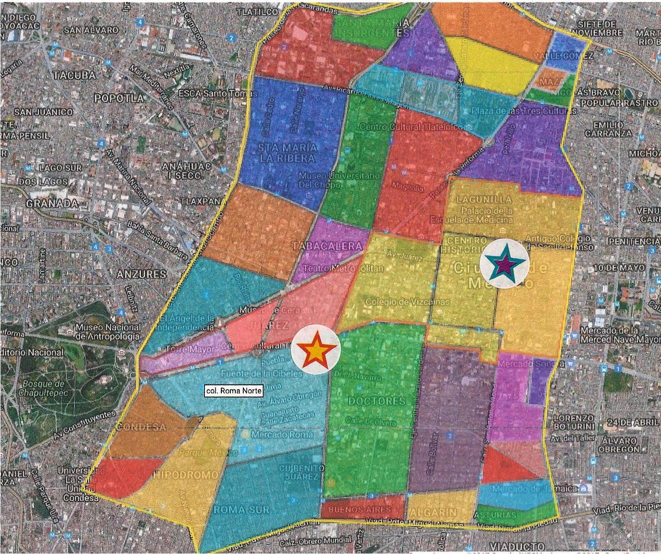
Delegación Cuauhtémoc
(light tan area)
was the site of ancient Tenochtitlan, 

now Centro Histórico,
in north central Mexico City

Delegación Cuauhtémoc

Aztacalco, now "La Romita", (red and orange star)
is a little less than two miles southwest
of the Templo Mayor of Tenochtitlan (green and purple star).

Another two miles further west is Chapultepec Woods, (dark green area)
The Mexicas built an aqueduct from the springs of Chapultepec
to Tenochtitlan.
Its pathway is now Avenida Chapultepec,
which passes along the north side of Aztacalco/La Romita.
See also:

Tuesday, September 15, 2015

Colonia Condesa and Its Sisters - From Past to Present, Part I: Transition to the 1920's

In our last post, Seeking Restored Vitality, we reviewed the colonias, neighborhoods, established at the end of the Porfiriato, at the turn of the 19th to the 20th century. Our focus was on the question of what made for the varying degrees of success we have observed in restoring their century-old, shared heritage of stylish homes and in integrating them with all the changes they underwent in that one hundred-plus years. 

Our answer was that two things seem to have made the difference. First is their proximity to the major axis of Paseo de la Reforma with its dynamic fusion of the Mexican version of a 19th century European boulevard and pedestrian promenade with the skyscrapers of the contemporary global economy. Second is their having "good bones," public streets and parks inviting people to walk, sit and enjoy what is around them. We concluded that, among the colonias we have explored, Colonia Roma Norte, with its relative proximity to Reforma and its "good bones," was most successful in this endeavor.

End of the Porfiriato, Transition to a New Epoch


With that perspective, following the (mostly) charming Álvaro Óbregon Avenue west from Roma Norte, we cross Insurgentes Avenue and begin our amble through the last of the Porfirian colonias, the one known as Condesa. Actually, the area is comprised of four colonias, or parts thereof:
  • Condesa, 
  • Condesa Hipódromo (Condesa Racetrack), 
  • Hipódromo, and 
  • One part of Roma Norte that—located on the west side of Insurgentes—is physically more connected to Condesa than to its eastern side.
Gathering this group into one neighborhood are the major thoroughfares that mark its boundaries on four sides:
  • Chapúltepec Avenue to the north,
  • Insurgentes to the east,
  • Benjamin Franklin to the south, and 
  • José Vasconcelos to the west. 
Chapúltepec Woods is just to the northwest. We refer to all of them as "Condesa."

CLICK to enlarge any photo.
A gallery of all photos will appear below it.

During the Colonial period, the land was a hacienda, a large estate, owned by a series of countesses, hence the name. The original mansion still stands on José Vasconcelos Avenue, in the southwest corner of Condesa Hipódromo. The U.S.S.R. Embassy throughout much of the 20th century, it is today the Russian Embassy surrounded by a high wall, which makes picture-taking a problem, even worse than the modern U.S. Embassy on Reforma.

In 1902, the owners decided to subdivide the hacienda into residential properties. The northern section was developed first as part of Roma. To the south, the Mexican Jockey Club opened a racetrack in 1910. In the 1920's, after the Revolution, it was closed, and the land was divided into residential lots.

destacada
Hipódromo of JockeyClub of Mexico as it was being converted into residential buildings in 1920s.
Larger, outer ring is Amsterdam Ave.
Photo: MXCity

The shape of the racetrack, however, was preserved, which accounts for the oval shape of Parque México and Amsterdam Avenue, which circles it, and for the name of that colonia, Hipódromo. We will find that this difference between pre- and post-Revolution origins in development of the colonias is reflected in their architecture.

The Two Hearts of Condesa

So let's begin with Condesa's "bones" and, extending the metaphor, its vital organs. Álvaro Óbregon leads us to a lovely, tranquil park virtually at the colonia's heart, Parque España.

Parque España 


From this serene core, wide spokes of tree-lined streets with shaded camellones, medians, spread out to the north, west and south.

Two short blocks to the southeast is Condesa's larger, and more active heart, Parque México. 

Art Deco clock points to the new architectural era in which the colonia developed

We will come back to Parque México, but first, let's stroll out some of the spokes, the "bones" radiating from Parque España.

The Bones of Condesa


Tuning north from where Avenida Álvaro Óbergon touches the park, we walk up Avenida Oaxaca. through what is actually part of Roma Norte.


Avenida Oaxaca is one of the few avenues in Mexico City with a row of palm trees

Along the way, we pass some old acquaintances:

Neocolonial home, now a restaurant


Amidst admittedly non-descript contemporary buildings, we have our first ecounter with a new, post-Revolution esthetic:

1930s-40s Art Deco

Oaxaca leads to a large traffic circle with a monumental statue at its center:

Fountain of Cibeles 

The Neoclassic Fountain of Cibeles [Anatolian earth goddess adopted by the Greeks and Romans] is an exact replica of one erected in Madrid, Spain, in the late 18th century. The copy, a gift of friendship from Spanish residents in Mexico City, but echoing the Colonial past, was installed here in 1980. The plaza around the statue was recently renovated and replanted with flowering plants.

Around the outside of the traffic circle are more Neocolonial and Neoclassic buildings. Housing cafes, restaurants and other shops preserve the Porfirian European ambience.


Continuing up Oaxaca to where it meets Insurgentes and Chapúltepec Avenues at the huge glorieta, traffic circle, we encounter other vestiges of the Porfiriato. They are, however, rather more down-on-their-luck than those around the Fountain of the Cibeles.


Second French Empire buildings on Insurgentes


Neoclassic mansion
(Sign indicates that current commercial tenant uses side entrance)

Reversing direction and heading back to the Cibeles Fountain, we angle southwest from Oaxaca and enter Calle [Street] Durango, the first of a chain of broad, shaded boulevards forming a semi-circle along the west side of Condesa, a kind of "ribcage" around the colonia's double hearts.

Camellón, pedestrian meridian down Calle Durango

And running north and south of Durango, on side streets named after Mexican cities such as Valladolid and Salamanca ...


...a quiet blend of tradition and definitely upscale, contemporary urban life.

Crossing Another Threshold

When Durango intersects with the wide Calle Veracruz, it bends more to the south and becomes Avenida Mazatlán. 

Neoclassic mansion at intersection of Durango, Veracruz and Tampico

Here we say goodbye to Roma Norte and enter Colonia Condesa proper.  We also find that we have crossed another threshhold, leaving behind the Neoclassic and Neocolonial of the earlier established La Roma for ...


... that nostalgic, eclectic hybrid we have met in other Porfirian colonias, California Colonial, with its spiral columns and ornate dooways. The architecture tells us that we have entered a neighborhood established in the 1920's and 30's.


But then there appears a 1930's apartment building adopting formal Neoclassic elements. 


Followed by more 1920's fantasy:

Medieval mixed with California Colonial, and
Moorish Revival


As Mazatlán approaches the southern limit of Colonia Condesa at Avenida Michoacán, we find ouselves moving into an area of predominately utilitarian, unimaginative Post-World War II construction, where the ornamentations of pre-war fantasies are left behind.

Seeking to uncover more of the early 20th century "dreamed city" in Condesa, we turn northeast, up Michoacán, and walk towards its heart, Parque México, and our next post.

Other Posts on the Porfiriato Era


Delegación Cuauhtémoc
The "Porfirian" colonias line the west side of Delegación Cuauhtémoc
From north to south they are:
Santa Maria la Ribera (violet)
San Rafael (medium pink)
Cuauhtémoc, (medium blue triangle)

South of Paseo de la Reforma
Benito Juárez (horizontal triangle of three adjacent pink sections)
Roma Norte (light blue) (Doctores, to the east, is a separate colonia)
Roma Sur (darker blue)

And to the southwest (lower left):
Condesa (medium pink)
Condesa Hípódromo (dark pink)
Hípódromo (pale pink)

Centro, and its five sub-divisions (Historico, north, east, south, west)
 is to the right center (almost white)

Monday, May 18, 2015

The Porfiriato: French Culture Conquers Mexico City

Porfirio Díaz

French Aesthetics Come to Mexico

After the Spanish Colonial period, and until the current era of global-style, post-modern construction, the architectural heritage of the Porfiriato, the thirty-five year period of the dictatorial presidency of Porfiro Díaz, (1877-1911), is the second most important era for shaping the look and ambience of the center of Mexico City.

Díaz undertook to turn the City into one modeled after Paris. He turned Paseo de la Reforma into a French-style boulevard, with monumental statues at major intersections, and he ordered the construction of many major government and civic buildings in the Historic Center. Wealthy Mexican and foreign businessmen built luxurious homes, which mimicked the styles of European royalty and the wealthy bourgeoisie, along Reforma and in new colonias, neighborhoods, to the north and south of it.

Angel of Independence,
Neo-classic momument modeled after Nike, the Greek goddess of Victory,
erected on Refoma by Porfirio Díaz
to commemorate the 100th anniversary of the initiation of
the War of Independence in 1910.

Former mansion on Reforma
 is now a bank branch
Photo: JRB

(left click to enlarge any photo)


Mini-"castle" on Reforma being demolished
for replacement by a skyscraper
Photo: JRB


It is another one of those curious, seemingly paradoxical Mexican stories how European esthetics, and particularly that of the French Second Empire of Napoleon III (1852-1870), came to be recreated in Mexico under Díaz' leadership. He was a mestizo (mixed, Spanish and indigenous) who, like Benito Juárez, came from the southern state of Oaxaca. Even more paradoxically, he had been a leading general in the War of Reform and the war against the French Intervention, instigated by that very Napoleon, a president who had turned himself into an emperor.   

From Humble, Provincial Beginnings

Porfirio Díaz was born Sept. 15, 1830 in Oaxaca City, Oaxaca. His mother, Petrona Mori, was the daughter of a Spanish immigrant and Tecla Cortés, an indigenous woman. Díaz's father, José de la Cruz Díaz was a criollo [pure Spanish, born in New Spain] and a modest innkeeper who died of cholera when his son was three.

Despite the family's difficult circumstances following the death of his father, Díaz was sent to school at age 6. The Díaz family was devoutly religious and, at the age of fifteen, Díaz began training for the priesthood at the Colegio Seminario Conciliar de Oaxaca, but important national events intervened. During the Mexican American War/U.S. Invasion of Mexico (1846-47), seminary students volunteered as soldiers to repel the U.S. invasion. Although he did not see action, Díaz realized that his true vocation was not the priesthood, but the military.

Díaz Joins Liberal Democrats

Also in 1846, Díaz came into contact with Marcos Pérez, a leading Oaxaca liberal, who taught at the secular Institute of Arts and Sciences in Oaxaca. Benito Juárez, who became governor of Oaxaca in 1847, had been a student there. Díaz met Juárez that same year. In 1849, over family objections Díaz abandoned his ecclesiastical career and entered the Institute to study law. 

When Antonio López de Santa Anna returned to power via a coup d'état in 1853, he suspended the 1824 Constitution and persecuted liberals seeking to re-establish the Constitution and democratic government. At this point, Díaz had aligned himself with radical liberals (rojos), such as Juárez, who was forced into exile in New Orleans. Díaz supported the liberal Plan of Ayutla that called for Santa Anna's ouster. Evading arrest, he fled to the mountains of northern Oaxaca, where he joined the rebellion of Juan Álvarez. 

During the War of Reform, the civil war of autocratic conservatives against the liberal, democratic government of Benito Juárez, Díaz became a colonel. In the subsequent War of the French Intervention, he participated in or led several crucial battles and was promoted to general. After the defeat of the French, the execution of Emperor Maximilian I and the return of the Juárez goverment to Mexico City in 1867, Díaz returned to private life in Oaxaca.

Díaz Switches Sides

In 1870, Díaz ran as a presidential candidate against President Juárez and Vice President Sebastián Lerdo de Tejada. He claimed fraud in the elections won by Juárez, and, in typical caudillo, military strongman, style, he announced a rebellion, the Plan de la Noria on November 8,1871, but this rebellion failed. Following the death of Juárez in 1872, Vice President Lerdo became president. Lerdo offered amnesty to rebels, which Díaz accepted and took up residency in Veracruz. In 1874, Díaz served in the federal legislature, representing Veracruz.

In 1875, Díaz left Mexico and went to New Orleans and then to Brownsville, Texas, to plot a rebellion. In 1876, he announced the Plan of Tuxtepec (a town in Oaxaca) as a call to arms against Lerdo, who was running for another presidential term. Lerdo was re-elected in July 1876, but the rebellion forced Lerdo from office. In November 1876, Díaz occupied Mexico City, and Lerdo went into exile in New York City. Díaz did not take formal control of the presidency until the beginning of 1877, placing General Juan Méndez as provisional president, until new presidential elections in 1877 officially gave Díaz the presidency.

The Thirty-Five Year Porfiriato

Diáz got himself "re-elected" president of Mexico over a thirty year period (1877-1911). For the upper-class, it was an era of political stability, industrialization and economic growth. For lower classes, it was a time of exclusion and suppression of protests. Díaz maintained control through "Pan o palo", "bread or a stick"an informal system based on personal loyalty using patronage and repression. His motto was "little politics and plenty of administration." The epoch was to end suddenly with the outbreak of the Mexican Revolution in 1910, when various forces of social, political and economic opposition exploded.

A Francophile City

Our focus is on the architectural identity Díaz and his supporters brought to the center of Mexico City. Perhaps most emblematic of this, Chapultepec Castle, with its Napoleonic ghosts of Emperor Maximilian, was, itself, transformed by Díaz into his summer palace, with the addition of such improvements as ornate Art Nouveau stained glass windows.

Diana, the Huntress
Photo: JRB


Strolling through the colonias built during the Porfiriato you almost feel that you are in some arrondissement of Paris, or, at least, in a tropical replica of the French capital. In subsequent posts, we will visit several of them: Santa Maria Ribera, San Rafael, Roma and Condesa

Entrance to mansion in Roma,
now University de Londres


Mansion in Benito Juárez,
now the Wax Museum
Photo: JRB

Houses in Santa Maria de Ribera
Photo: JRB

Window of apartment in San Rafael
Foto: JRB


But first, we will return to the Centro Histórico to explore the Neo-classic, Beaux Arts and Art Nouveau aesthetics of such Porfiriato constructions as the Museo Nacional de Arte (National Museum of Art), the Palacio de Correos (yes, a post office that is a palace), the Alameda Central park, the Palacio de Bellas Artes (yet another palace) and commercial buildings of the epoch.