Showing posts with label pueblos originarios. Show all posts

Friday, July 7, 2017

Original Villages | Tláhuac: Crossroads Between Two Lakes and Two Cultures

The Outer Boroughs


Since the spring of 2016, we have been ambling through several of Mexico City's sixteen delegaciones, or boroughs, seeking out the indigenous pueblos that existed around the lakes and on their islands in the Valley of Anahuac (now the Valley of Mexico) before the Spanish arrived and subjugated them. In doing so, we have discovered that there is a definite geographic difference in their distribution among the delegaciones and in the degree of their continuing vitality and conscious identity as original villages.

Delegaciónes (boroughs) of Mexico City
Cuauhtémoc, in north center, now Centro Histórico,
is the site of Mexico-Tenochtitlan


In the north of the City, Delegación Cuauhtémoc, site of  the Zócalo, the "Heart of the City" and the original Mexica city of Tenochtitlan, and adjacent delegaciones such as Benito Juárez and Miguel Hidalgo, are some such pueblos, or at least vestiges of them in the form of Catholic churches built by the Franciscans and other religious orders in the 16th century.

In Cuauhtémoc, around the Centro Histórico, which the Spanish took over for themselves, there were four indigenous barrios carried over by Cortés from Tenochtitlan, as the Republic de San Juan Tenochtitlan, whose original churches (or later replacements), plazas and mercados, markets, remain. Tacubaya and Tacuba in Miguel Hidalgo, are two examples of pueblos in adjacent delegaciones where churches, plazas and a few other vestiges of the transition from the indigenous to the Spanish Catholic world remain.

In the western, rural, mountainous delegaciones of Cuaujimalpa and Magdelena Contreras, vital original pueblos exist, but getting there is a challenge we still seek to overcome. However, the largest concentrations of original pueblos lie in the southern delegaciones. Our own Coyoacán contains at least a dozen. In neighboring Iztapalapa, Xochimilco and Tlalpan are many more. The far southeastern delegations of Tláhuac and Milpa Alta are, or have been until recently, rural areas consisting totally of traditional pueblos.

Traveling around Coyoacán is easy for us; however, traveling into the "outer boroughs" of Iztapalapa, Xochimilco, Tlalpan, Tláhuac and Milpa Alta is more of a challenge. They require longer rides on the Metro, if a line even exists, or extensive taxi trips. Tlalpan and Milpa Alta have no Metro; Tláhuac has only recently become reachable with Line 12. 

Probably more a factor is that most of their pueblos, barrios and newer post-WW II colonias (except for Tlalpan) are barrios populares, working-class neighborhoods with reputations for being unsafe. Many chilangos (Mexico City residents) from the central delegaciones consider them "dangerous"  and won't go there. Nevertheless, with the help of our friend and guide, Alejandro, who lived in Iztapalapa, we made initial forays into some of these outer boroughs. However, Alejandro recently moved to Guadalajara, far to the west, so we have been left on our own. 

As we have commented in other posts on these boroughs, we have found that it is perfectly safe to visit them when there is a fiesta being celebrated that brings el pueblo, the people as a community, into the streets, along with the community leaders who have organized the celebrations through their centuries-old system of mayordomos and their supporting committees. These committee members are almost always identifiable by their colorful shirts with the fiesta name written on them or by wearing ID tags.

Our consistent experience has been that members of el pueblo always warmly welcome us and our interest in their customs. Our visit to the old center of Iztapalapa for its Passion Play is, perhaps, the most outstanding example. But every Amble to these fiestas in the "outer boroughs" has been a wonderful experience of the ánimo, spirit, of el pueblo, expressing and celebrating its primary identity, and of its amabilidad, kindness to fuereños, outsiders who show respect for their traditions and treat them comfortably as prójimos, fellow human beings.

On to Tláhuac


We have made progress in fulfilling our goal of becoming acquainted with some pueblos in Iztapalapa and Xochimilco, but except for an initial, exploratory visit with Alejandro some months ago, we had not gotten to Tláhuac (the reddish-brown area on the lower east side of the City map above). A couple of weeks ago we learned, via our new "guide", the Facebook page of the Fiestas Mágicas de los Pueblos y Barrios Originarios del Valle de México (Magical Festivals of the Original Pueblos and Barrios of the Valley of Mexico) that the patron saint day of San Pedro, St. Peter, was going to be celebrated in Tláhuac for the entire last week of June. What appeared to be the high point of the fiesta, a procession, was scheduled for late afternoon on Wednesday.

So on that Wednesday afternoon, we head off east, first via taxi across eastern Coyoacán to Culhuacán in Iztapalapa, then southeast via the Metro's new Line 12 to its final stop, Tlálhuac, or more precisely, San Pedro Tlálhuac. Traveling above ground, we get a good,closeup view of la Sierra Santa Catarina, a row of ancient, extinct cinder cone volcanos that forms the border between Iztapalapa and Tláhuac.

Tecuauhtzin and Guadalupe,
the two easternmost volcanoes in the Santa Catarina chain
marking the boundary between Iztapalapa and Tláhuac.
Cerro de las Estrellas, Hill of the Star in Iztapalapa, is the most western volcano.

Ancient Roots in Lake Waters


Cuitláhuac (circled in blue), shortened by the Spanish to Tláhuac,
was situated on an island between Lake Xochimilco (to the west)
and Lake Chalco (to the east).


The area of what is now the Delegación of Tláhuac, in southeast Mexico City, shows signs of human occupation at least from the Preclassic period of Mesoamerica (1800 BCE–200 CE). The island of Cuitláhuac and the Tlaltenco riverbank (on the Iztapalapa peninsula, north of Lake Xochimilco) were occupied by agricultural villages at a time contemporaneous with the development of Cuicuilco (c. 700 BCE – 150 CE, west of Lake Xochimilco and buried when Xitle volcano erupted).

In the environs of Tlaltenco remains of ceramics have been found that date to the year 1500 BCE and correspond to a village located on land what is known as Terremote Tlaltenco. Equally old vestiges of human occupation have been found in San Juan Ixtayopan, located in the southeast of Tláhuac on the slope of the volcano Teuhtli. Both the Tlaltenco and Ixtayopan sites were abandoned by the end of the Late Preclassic period, when Teotihuacan became the main political and urban center of the Mexican basin.

In 1222 CE, a Nahua group founded Cuitláhuac—the present San Pedro Tláhuac—on a small island between lakes Xochimilco and Chalco. It is thought they came from nearby Xochimilco, founded three hundred years earlier. Around the island, they created chinampas—man-made islands like those first invented in Xochimilco for growing produce.

Models of chinampas at the San Pedro fiesta,
Created by a community group seeking to preserve this ancient form of horticulture
that is quite modern in its use of "all natural" techniques.

Cuitláhuac did not remain an independent altepetl, city-state, for long. In 1230, the altepetl of Chalco-Atenco (to the east, today in the State of Mexico) conquered Cuitláhuac, Míxquic and other lakeside pueblos that are now part of the borough. In 1393, Azcapotzalco (on the west shore of Lake Texcoco) subjugated the Cuitlahuacas, as it had most of the Valley.

In 1428, the Triple Alliance of Tenochtitlan, Tlalcopan (now the Colonia Tacuba) and Texcoco (on the east side of Lake Texcoco) defeated the armies of Azcapotzalco. The Mexicas of Tenochtitlan, as the dominant power, took control of Cuitláhuac. As they did in Lake Texcoco, they built a causeway to connect Cuitláhuac to the north and south shores of the lake.

Goal from indigenous ball court
at the site of Church of St. Peter
on the former island of Cuitláhuac

Hernán Cortés and his soldiers passed through Cuitláhuac to reach the Iztapalapa peninsula and its causeway leading to Tenochtitlan. After the defeat of the Mexicas in 1521, as part of what has come to be called the Spiritual Conquest, the Franciscans built the church of St. Peter the Apostle on the site of an indigenous temple on the island of Cuitláhuac. At the end of 16th century, St. Peter's was transferred to Dominican control.

Tlálhuac, with St. Peters Church, on Cuitláhuac Island,
with causeways constructed by the Mexicas.

From:
 Atlas eclesiástico de el Arzobispado de México, 1767
Templos y Capillas del México Viejo, Delegación Tláhuac.

From the colonial period through the 19th century, Tláhuac alternated being under the governance of either Xochimilco or Chalco. In 1928, it became a delegación (borough) of the Federal District, now Mexico City.

Until the 1980s, Tláhuac was a rural borough of original indigenous villages, surrounded by chinampas in the former Lakes Xochimilco and Chalco. Together with neighboring Xochimilco, it was part of the area declared Patrimony of Humanity by UNESCO in 1987. During the last thirty years, as with Xochimilco, Iztapalapa, Tlalpan and other peripheral boroughs, the demographic pressure from Mexico City has resulted in the borough's rapid urbanization, such that the urban areas now cover approximately a third of it (see delegacion map below). Wikipedia

Seven Pueblos


In Tláhuac are seven native pueblos from pre-Conquest times, each having a dual Spanish saint and indigenous name:
  • Santiago (St. James) Zapotitlán, 
  • San Francisco (St. Francis of Assisi) Tlaltenco, 
  • Santa Catarina (St. Catherine) Yecahuitzotl, 
  • San Pedro (St. Peter) Tláhuac; 
  • San Juan (St. John the Baptist) Ixtayopan;
  • San Nicolás (St. Nicholas) Tetelco; and 
  • San Andrés (St. Andrew) Mixquic.

Seven Original Pueblos of Delegación Tláhuac
(Each pueblo is divided into various barrios)

Green/yellow star in the center marks site of Delegación offices
and Church of St. Peter in the original Pueblo of Cuitláhuac,

now San Pedro Tláhuac.

(Just to the east of San Pedro is a remnant of Lake Chalco. 
Gray-green areas marked by rectangles are chinampa fields.
Other gray green areas to the north and south are volcanic mountains)

Northwest of San Pedro Tláhuac (on the former north shore of Lake Xochimilco) are:
 Pueblos Santiago Zapotitlán (red/orange star) and 
San Francisco Tlaltenco (red/yellow star)

Northeast is Pueblo Santa Catarina Yecahuitzotl (purple/orange star)
(on the former north shore of Lake Chalco), 

Southeast (on the former south shore of Lake Chalco) are:
San Juan Ixtayopan (orange/red star),
San Nicolás Tetelco (mustard/yellow star), and
San Andrés Mixquic (navy blue/red star)


Pueblo San Pedro Tláhuac


The Tláhuac Metro station is a half-mile or so from the center of Pueblo San Pedro Tláhuac, so, upon leaving the station, when we see no taxis, we take one of the ominpresent gray and green jitney buses for the short ride south. 

On the left side of the two-lane road are the simple, concrete block buildings typical of a Mexican village. In contrast, on the right are fields, some growing corn or other crops; cows and horses graze in others. Narrow canals crisscross the fields, irrigating them. These are the chinampas, the man-made islands built up centuries ago in what were once Lakes Xochimilco and Chalco, surrounding what was once the island of Cuitláhuac, now the Pueblo of San Pedro Tláhuac.

In a few minutes we come to a plaza with a bright orange mercado, indoor market, on the far side, and what looks like an old ayuntamiento, "town hall" on our right, which we recognize from our earlier visit with Alejandro, so we know this is where to get off the bus.


Traditional ayuntamiento, "town hall", with its Spanish-style portico.

Plaza,
filled with many puestos, for the fiesta or fair,

as signs tell us it is called here.

Across the street, to one side of the plaza and behind the ever-present street puestos, commercial stalls, and some juegos mechanicos, fair rides, we can see the entrance to the atrio, atrium, of the Church of San Pedro. Certainly, we have here all the physical ingredients of a pueblo: a plaza surrounded by a market, a government office and a church, the trinity of Commerce, the State and God.

Fiesta Preparations


The doorway to the atrio is decorated with a portada,
unusual in that it is made of reeds that grow in the canals,
instead of the usual flowers.

St. Peter's Atrio
It is also unusual in that it is filled with several huge royal palm trees,
which, strangely, aren't that common in Mexico City.

"Long live St. Peter, the Apostle"
Papel picada, cut paper (now plastic),
announces the celebration of the patron saint's day.

Church of St. Peter the Apostle,
built by Franciscans sometime after 1529,
handed over to Dominicans in 1554.

The design on the facade is mudéjar, Moorish, i.e. Muslim.

Typical of patron saint fiestas, the sanctuary is filled with fresh flowers,
likely grown in Tláhuac's own chinampas.
St. Peter sits at the center of the Baroque retablo, reredos,

probably added in the 18th century.

Going through a side door and down a few steps
we enter the cloister of the convent or monastery,
built by the Dominicans in 1586.

The Celebration Gets Underway


Outside, a band is playing 1950s show tunes
and songs from the U.S.
The band is that of
the Mexico City Police Department.

This, too, is a first in our fiesta visits.

Soon, St. Peter is brought out of the church.
As Christ´s chosen leader
and first Pope of the Catholic Church,
he holds the keys to the Kingdom of Heaven.

The banda, an essential component of a procession, arrives and begins to play.

Acolytes appear

A Queen and two Princesses of the Fiesta arrive.
They pose for us, as beauty queens are supposed to do.
The addition of a beauty pageant to a saint's day is

also something new in our experience.

The priest appears.

With the emergence of the priest from the church, all the components of a traditional saint's procession are present. However, while a number of people look on, more are listening to the police band or eating food purchased from a number of vendors lining the atrio walkway. This does not seem be one of those processions we have witnessed where more or less significant numbers of parroquianos, members of the parish, participate. Perhaps more will join along the way, which is often the case.

The procession starts off.

At this point, another representation of St. Peter is brought from the church.
Above him is the name Cuitláhuac, the original name of the pueblo.

The saint is accompanied by two more females, attired in traje traditional, 
traditional dress, who also readily strike beauty queen poses for our camera.

As with the "Queen" and two "Princesses",
we get the feeling this is as much a beauty pageant
as a saint's procession.

Procession into the Darkness


The procession starts off, but it is starting to get dark. Black clouds are gathering. It is the rainy season, so we decide not to follow, as we usually would.

We learn the next day, from the Magical Festivals Facebook page, that the procession takes an unusual path. 


A waterfall of light

St. Peter, in both his representations, is carried to an embarcadero, a pier on the canals, placed in trajineras, flat-bottomed boats, and poled out onto the waters. As darkness falls, they are honored with a pyrotechnic display, a waterfall of light. Quite special, clearly a meeting of the Catholic saint, the First Pope, with the ancient world of his indigenous pueblo. Another unique manifestation of the Spiritual Conquest, or better, of the reconciliation of two disparate worlds.

We are both moved by this hidden climax and saddened that we could not witness it. Quizá, otra vez. 
!Ójala! Perhaps, another time, God willing!

Saturday, June 10, 2017

Original Villages | Delegación Miguel Hidalgo: Tacubaya - Labyrinth Leading from the Present to the Past

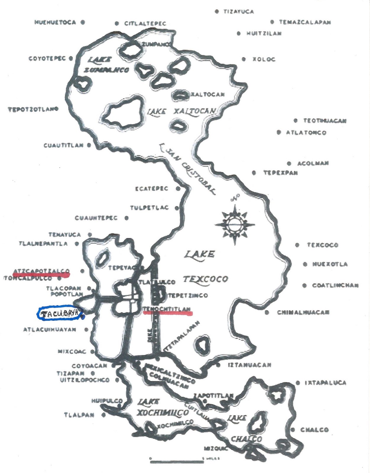
In our effort to visit as many as possible of the original indigenous villages now incorporated into Mexico City, we have, for some time, wanted to visit Tacubaya, in a part of the Delegación Miguel Hidalgo that is to the south of Chapultepec Woods.

Tacubaya
lay on the southwest shore of Lake Texcoco.
Until 1428 it was under the control of the Tepanecs of A(t)zcapotzalco.
After the Mexica of Tenochtitlan defeated A(t)capotzalco,
it came under their control.

The area has been inhabited since the fifth century BCE. Archeological evidence shows continuous human habitation here since between 450 and 250 BCE by chichimecas, hunter-gatherer tribes. The Mexica tried to settle here in 1276 but then left in 1279. It was renamed Atlalcuihaya by the Mexica of Tenochtitlan when they took control in 1428, after defeating Azcapotzalco, which had dominated the west shore of Lake Texcoco. The name meant “where water is collected.” This name was Hispanicized to Tacubaya by the Spanish. Wikipedia

We had previously explored Tacuba, another original village north of Chapultepec. However, Tacubaya has a reputation for being a poor, unsafe area, so we were hesitant to go. Recently, on Facebook, there appeared an announcement of a tour of Tacubaya led by a chilango, Mexico City resident. Seeing this as our opportunity to go there with others, we called and made a reservation to join the tour. The following Sunday morning, we took our Line 2 of the Metro north to the Chabacano Station, where we changed to Line 9, which heads west and ends at Tacubaya

Finding Our Way Through Labyrinths


The Tacubaya station is a labyrinth of long tunnels and many stairways, as three lines cross there, the third being Line 7. We have been in the station before to view the wonderful murals by Guillermo Ceniceros portraying the gods of the Mexica and foundational legends of how in 1225 they came to arrive in the Valley of Anahuac, now the Valley of Mexico. 

Jade death mask of an indigenous king.
by Guillermo Ceniceros
Tacubaya Metro Station

Metro stations have good signage, directing travelers through the correspondencias, connections between one line and another. The leader of the tour has told us to meet him at "the exit to the Periferico (ring road expressway) from Line 1", so we follow the signs leading to Line 1. 

When we arrive in the area of Line 1, a large, two-story hall leading to multiple exits, we ask a policeman where the exit to the Periférico is. He seems puzzled but points us in a direction. Farther on, we ask a subway employee where the exit is in order to confirm we are on the correct path. Again, the person seems puzzled by our question, but points us in the same direction. 


We exit up some stairs and find ourselves near the entrance to a very large mercado, indoor market, that faces a large plaza mostly covered with concrete, yet containing a few trees, many free-standing puestos, merchant stalls, and a juego mecánico, carnival ride. We ask a couple of the puesto merchants if this is the exit to the Periférico. Again, they seem puzzled, but clearly thinking that we want to go there, indicate that the Periférico is on the other side of the mercado. 

It is a few minutes past 10:30, the appointed hour for the tour group to meet, but none of the people standing around the Metro entrance look to be candidates for such an adventure. They are mostly teenagers and adults hanging out on a Sunday morning. Not at all sure we are at the correct exit, but even more unsure about finding an alternative one, we call the tour leader's cell phone. There is no answer. We repeat the call several times over the next several minutes, with the same lack of result. 

Going It Alone Through a Labyrinth


Finally, we accept that we are on our own. Since we have made it to Tacubaya, we decide not to waste the trip and to seek out its historic buildings on our own. It is near noon on a Sunday, the safest time to wander about the city, as parents have the day off from work and take their familes out to church, one market or another, maybe to a museum (which are free on Sundays) or just for a paseo, stroll, though some plaza, park or along a tree-lined boulevard.

Our first destination is such a park, the Tacubaya Alameda, and a church likely to be having Mass, the Church of Nuestra Señora de la Purificación, Our Lady of the Purification. This Lady is the Virgin Mary at the moment of her purification forty days after the birth of Jesus, when she presents herself and the infant at the Temple in Jerusalem to be blessed by the priests. Her annual festival, on February 2, is Candelaria (because participants traditionally hold lighted candles), so the church is also better known as la Parroquia de la Candelaria, the Parish Church of Candelaria.

So we approach more merchants and ask directions to the Alameda and church. They point us along one of the multi-lane streets and highways that crisscross the area and tell us that, at a certain point, we will cross a pedestrian bridge. This leads us through what could only be described as another modern-day labyrinth. 

Puestos line an underpass beneath a major street.
This seems to be the "mens' wear" section.

Literally every centimeter of the way is lined with puestos, including an underground passageway. Tacubaya is certainly a good example of the muliple ways markets, broadly defined as any place where merchants and customers meet to sell and buy, are realized in Mexico City! 

Coming up from underground, we soon spot a pedestrian bridge over yet another multi-lane street. We confirm from a merchant that the bridge leads to the Alameda and the Church. 

Tacubaya Alameda


Tacubaya Alameda

We soon arrive at the Alameda. The Wikipedia article on Tacubaya warns us that the park is "full of drug addicts, alcoholics and garbage", one of the reasons we were leery of coming to the area. But we don't spy any of the three plagues of urban parks (we are familiar with them; we lived in Manhattan in the 1970s). A policeman sits on his motorcycle eating a snack. Parents and children are taking a Sunday morning paseo. In one corner, a group is listening to an evangelical religious sermon. The sidewalks are in excellent condition and the traditional cast iron benches are freshly painted. These are all positive signs the park is currently being cared for by the government of the Delegación Miguel Hidalgo.

In the center is an obelisk honoring the Mártires de Tacubaya, the Martyrs of Tacubaya, soldiers who died fighting for the Reform government against conservative generals who had declared support for the Plan of Tacubaya, a rebellion against the new, liberal constitution of 1857. The generals used Tacubaya, then a village outside Mexico City, as the base for their uprising, which led to the so-called War of Reform (1857-1860). During the War, Benito Juárez became president in exile, returning to the City when the conservatives were defeated. 

Benito Juárez' triumphant re-entry into Mexico City,
January 1861
Juárez is the middle one of three men in black suits.
Painting in the National History Museum,
Chapultepec Castle

Walking through the Alameda, we come to the wide Avenida Revolución, a main north-south Eje, Axis road, and see the wall of the atrio, atrium, of the Church of Candelaria on the other side.

The Church of Candelaria  


Church of Nuestra Señora de la Purificación, Our Lady of the Purification,
aka Church of Candelaria

The atrio is a large, tree-filled, quiet retreat from the traffic noise of Avenida Revolución and the barullo, din, of the nearby mercado and ubiquitous puestos. It is one of those classic, tranquil Spanish Colonial spaces hidden within, and in total contrast to, the city around it. 

Church atrio

First Call


As we approach the church door, we hear a single toll of the church bell, followed by a series of tolls. A man standing to one side of the door is pulling a rope that leads upward to the bell tower. As he finishes, we comment, "First Call to Mass." He smiles and nods.  We had learned the system of bell tolls when we lived in Pátzcuaro, Michoacán, which has many churches, such that bells ring frequently every day of the week. 

Our Spanish teacher clarified that they are not marking clock time but are preparatory calls announcing a coming Mass. About twenty minutes before the service is scheduled to begin, a single toll of the bell announced First Call. Ten minutes later, Second Call begins (or depending on local custom, ends) with two tolls; then as Mass begins there is Third Call, initiated or ended with three tolls. All the tolling of the bell that takes place after or before the telltale toll(s) serves for nothing more than getting people's attention.

Sanctuary
As First Call to noon Mass has just been sounded,
only a few parishioners are present.
We especially love the azulejos, blue tiles of Islamic origin.

The sanctuary retains the simplicity of the early churches founded by the religious orders. Our Lady of the Purification is the only 16th century Dominican church remaining in Mexico City. The date 1590 is inscribed into the walls, and in the arches the names of the indigenous peoples who helped in its construction are inscribed: Tlacateco, Huitzilan, Nonohualco and Tezcacuac.

"Queen of the Holy Rosary, pray for us."
The Virgin Mary and the infant Jesus,
also in a simple artistic style.

Walking along one of the side aisles, we notice a door opening to the outside. Such doors usually lead the way to a patio or inner courtyard surrouded by a cloister, containing monks' rooms above and dining rooms and other common spaces below. Stepping over the threshold, we are not disappointed.


The rooms around the courtyard are still being used by the church, which is not always the case. During the Reform Period (1857-75) and after the Mexican Revolution (1910-1917), the cloisters were often taken over by the government as part of its effort to reduce the wealth and power of the Catholic Church. They were put to secular use. Now many are museums or government offices.

Another door leads from the patio out into a side street where we glimpse some interesting buildings.

Colonial Period or 19th century homes

Because of its natural beauty, during the Colonial period, the Spanish came to Tacubaya for respite from the City's Centro. Even after the Mexican War of Independence (1810-20), Tacubaya remained a popular getaway for the wealthy. Many of the well-to-do bought land here for second homes, making the area a summer-home suburb of Mexico City, similar to Mixcoac, Villa Coyoacán, San Ángel and Tlalpan to the south of the city. Across the side street from the church are two of the only such homes we have seen on our amble through what is now mostly a working class commercial area dominated by highways and puestos.

Returning to the front entrance of the church and passing again through its wonderful atrio, we step out onto Avenida Revolución and into all its modern barullo. Since our next destination is somewhere to the west of the mercado and Metro Station and the church is on the east side, we hail a taxi to avoid any attempt to wend our way on foot through the labyrinth of puestos and highways that lies between them. 

Museum of Cartography and the Convent of San José


When we tell the driver who stops for us where we want to go, the Museum of Cartography, he says he doesn't know where it is, but when we say it is at the corner of Avenida Observatorio and the Periférico, he replies, "Está bien"—"That's fine."

We make some turns and are soon on Observatorio, another multi-lane commercial street, heading west. Shortly, we see the two-level Periférico expressway crossing ahead of us. The driver stops and we get out.

In front of us is a very large, two-story building of Neo-classic style, obviously from the 19th century. Mexican Army soldiers are standing guard at the entry gate. We approach and ask if this is the Museum of Cartography, which we know is operated by the Army. They tell us, "No," it is the School of Military Studies. The Museum, they say pointing to an underpass below a Periférico entrance road, is just up Observatorio. Just then we see a sign identifying the museum, so we enter the tunnel.


Coming out of the tunnel, we see some stairs leading up to an ornate metal gate. Climbing the stairs, we come face to face with the museum.  Between us is a very attractive brick-paved atrio, but this one is not a peaceful refuge from the city. It is open to the two-level Periférico on one side and the entrance road on the other. Behind us is Avenida Observatorio. We have found a small island of the past in the midst of a contemporary urban sea.

A metal plaque on one side of the atrio tells us its story. Shortly after they arrived in the 1520s, the Franciscans established a "visiting" chapel in Tacubaya, where friars came weekly to administer the Sacraments and teach the indigenous people about Catholicism. This chapel was thus another outpost of the Spiritual Conquest. In 1590, a suborder of the Franciscans, the Order of San Diego, came and built the original convent. dedicated to San José, St. Joseph, Jesus' "godfather", the same saint to whom the first Franciscans who came to Nuevo España in the 1520s had dedicated their homebase convent in Centro. The "Diegans" were the same order that built the Convent of San Diego in Coyoacán, in what is now San Diego Churubusco. In 1686, the order built the church we see in front of us. Shortly afterwards, in the early 1700s, the convent was transferred to the Dominicans. 

Closed in the 19th century as part of the Reform expropriations, it was subsequently used by the Army and other government agencies, and even closed at various times. In 2000 the Secretariat of Defense, i.e., the Army, took it over to create the Museum of Cartography which displays many old maps of Mexico City, Mexico and the Caribbean region.

The former sanctuary has the simplicity of the Franciscan churches.

Returning to Avenida Observatorio, and having accomplished all of our goals of the day, we plan to take a cab back to the Metro, as we are tired and don't know how long a walk it would be. 

A Guide Out of the Labyrinth


As we walk by the School of Miliary Studies, one of the soldiers we had spoken to on our arrival calls out to us, "¿Comó se fue?"— "How'd it go?" "Muy bien", we call back. "Very well."

At that point, he comes out from the gated entrance and walks over to us. "Where are you going now?" "I'm catching a taxi to get to the Metro."

At my reply, he offers, "Oh, you don't have to do that. The taxi would have to make many turns and the Metro is just down the hill. See that yellow pedestrian bridge (about two blocks away)? Cross over and the mercado is just on the other side. The Metro is just beyond." 

We thank him mucho, adding that we had arrived at that Metro exit by the mercado. This soldier is another example of Mexican amabilidad, kindness, consideration, that we consistently meet on our Ambles around the city, and as we have in our journeys around the country. There is always someone ready and willing to help you out. There is always a guide to show you through whatever labyrinth you may feel you are in.

Delegación Miguel Hidalgo
is the dark brown area in the northwestern part of the city.
Just west of Cuauhtémoc, the location of Centro Historico.

Colonias of Delegación Miguel Hidalgo

Tacubaya (red and orange star)
is at the southern edge,
south of Chapultepec Woods (dark green area).


Tacubaya (green area)

Red/orange star in middle is the Mercado.

Green/yellow star to the right is Church of the Candelaria 
(acutally in another colonia).
The Alameda is to its left, across Ave. Revolución.

Mustard/yellow star, upper left, is Museum of Cartography.

Note how crisscrossed the colonia is with major highways and avenues,
making walking around it like a trip through a labyrinth.

Wednesday, April 12, 2017

Original Villages | Iztapalapa's Holy Week Passion Play: Part I - Palm Sunday

When we moved to Mexico City nearly six years ago and settled into a fifth-floor apartment in Colonia Parque San Andrés in Delegación Coyoacán, we discovered that we had a view of a low, tree-covered hill about five miles straight east.

We soon learned that the hill was called Cerro de la Estrella, Hill of the Star. An extinct volcano, it played a significant role in indigenous history as the site of a temple where the xiuhmolpilli (sheeoo-mol-PEEL-yee), the Binding of the Yearswas enacted every fifty-two years by the Mexica (Aztecs). This date marked the point in time when the first day of the 365-day Solar Calendar and the first day of the 260-day Divinatory Calendar, based on the human gestation cycle, coincided—a critical juncture of human and cosmic destiny. In Spanish, it has been called Nuevo Fuego, the New Fire ceremony, as fires in all the pueblos were extinguished and a new fire was lit as part of the sacrificial ritual. 

So we made the Hill, called Huizachtecatl by the Mexica, one of the first historical sites we visited, relying on a taxi driver to take us to the Delegación of Iztapalapa and up the hill to where the Museum of the New Fire sits. A gate on the road means visitors have to walk from there up to the summit, which we did. (See our post on Hill of the Star for the history of the hill and the foundation of Iztapalapa at its base). 

Subsequently, we heard of the Passion Play that is put on each year by the people of Iztapalapa during Semana Santa, Holy Week. We were intrigued, but when we heard that as many as four million people attend the Good Friday reenactement of the Crucifixion of the Christ under the hot sun of an April afternoon—and that Iztapalapa was "dangerous" because of "a lot of crime", we were dissuaded from trying to attend. 

However, over this past year, as we engaged in exploring the original indigenous villages of the City as part of our Mexico City Ambles, we came to realize that we needed to go to Iztapalapa—one of the most important such pre-hispanic setttlements. During our explorations we quickly learned that the best time to visit these barrios and pueblos is when el pueblo, the people, are holding a fiesta—vividly, energetically and proudly celebrating their centuries-old communal identity. So we knew that we had to visit the original barrios of Iztapalapa during Semana Santa and witness its Passion Play. Fiestas are also the safest time to visit an unknown neighborhood, as the community, including its leadership, is out in the streets. 

Day of Palms

So at about 11am this Palm Sunday, we board Line 12 of the Metro at Estación Ermita (the Hermitage Chapel) and head east. Traveling underground we know that we are crossing what was the channel between Lake Xochimilco to the south and Lake Texcoco to the north. The next stop, Mexicalcingo, marks the beginning of what was the Iztapalapa peninsula before the lakes were drained. At the next station, Atlalilco, we change to Line 8.

Exiting at the next stop, the Izapalapa station, we find ourselves on Calzada Ermita-Iztapalapa, the wide boulevard that follows the path of the original Mexica [meh-SHE-cuh] causeway that began in Tenochtitlan and, at its southern end, divided to connect Coyoacán on the west shore with Iztapalapa on the east shore.  

We immediately know that a typical Mexican fiesta is in progress. The street has been closed to traffic, and families are walking in the roadway. As always, there are vendors selling. As it is Palm Sunday, the main item is palm fronds woven into itricate patterns.


We follow the crowd into the first side steet which leads to the main plaza of Iztapalapa a block further on. 

Los Nazarenes

The first thing that strikes our attention are numbers of men and boys dressed in purple robes. Purple is the color of penitence for the Season of Lent. These must be the Nazarenes who participate in Holy Week processions as an act of penitence, often walking barefoot and sometimes carrying a cross. We had seen them in such processions in Pátzcuaro, Michoacán, where we lived before coming to the City. Here they are holding large palm fronds. We have read on the internet that Palm Sunday in Iztapalapa involves a procession recreating Jesus' entrance into Jerusalem.


As they are obviously involved in the procession, we approach them and ask when the procession begins. Being muchachos, teen-age boys, their answer is rather lacking in specifics. They say it will pass by here at some later time this afternoon.


So we walk along the side of the plaza, which is hidden behind vendor's puestos, stalls. We ask some adults about the procession and one tells us it begins at the church on the other side of the plaza. 

So we head across the plaza, a large, pleasant, tree-filled space.


Wending our way though the puestos on the far side, we see the wall of the church atrio, atrium and find an entrance.

The Church of St. Luke

Church of St. Luke

It is the church of San Lucas, St. Luke, the parish church for the Barrio de San Lucas. The atrio is full of people, some obviously in costumes for the Passion play. Others wear orange T-shirts identifying them as security staff. And still others who have come to watch the spectacle. Inside, Mass is in progress.


From the front door we can glimpse behind the altar a bearded figure with long, flowing hair in a white robe, At his side stands a woman in a blue shawl. It is Jesus the Christ and his Mother, the Virgin Mary. Behind them stands a very blond angel. It must be the Archangel Gabriel. A priest is speaking from a lectern to one side.

Once again in our ambles, we have found what we were looking for. This time, it's the Son of God and the Mother of God, or at least actors representing them. Semana Santa is starting off in Iztapalapa at full steam. The Passion Play is about to begin.

Some Actors

We turn from the sanctuary entrance back towards the waiting actors. We wonder what roles they will be playing. We have read that only residents of the eight original barrios of the indigenous altepetl, city-state of Iztapalapa­—San Lucas, Santa Bárbara, San Ignacio, San Pablo, San José, San Pedro, La Asunción and San Miguel—can participate. There are 136 principal speaking roles, along with another 275 actors and 500 extras. We approach some in distinctive costumes, introduce ourselves and ask about their role.

He is to play a blind man.
This beautiful young woman
tells us she is playing "a virgin".


Mary Magdalene
A "lady of the night"


Disciples

Disciple

Hebrews

Others who—while not in costumes—seem to be related to the play.

These two gentlemen, wearing sashes that say
Society of Jesus of Nazareth.
tell us they have responsibilty for accompanying "el burrito", the little donkey.

At about this point, two men in orange shirts approach us and ask if we are "press". We say that no, we are a retired estadounidense, USer, with una gran inquietud, a great curiosity, about the original pueblos of the city and that we have a blog on the Internet where we publish stories and photos of our paseos. We hand them our Mexico City Amles/Paseos card. They energetically welcome us and offer any help we may need. 

Security

We tell them it would be helpful to know the schedule of events for the coming days, so we would know when to arrive. They tell us there is a Web page for the Semana Santa Passion Play with the schedule, but basically, if we come at 4PM on Tuesday and noon on Thursday and Friday, we will see the important scenes. We thank them for being tan amable, so kind and considerate.


The Play Begins   

Soon, there is movement in the crowd near the right side of the church. Evidently, something is about to happen. Within a few minutes, over the heads of the crowd, we can see the top of a statue of a saint moving towards us—the sure sign that the procession is beginning.

Lord Jesus on el burrito, the little donkey

Nazarenes

The donkey statue and the Nazarenes are followed by the Son and His Mother, Jesus and Mary.

Jesus, Mary and the Archangel Gabriel

We are immediately struck by the actors. Jesus is over six feet tall, broad shouldered, with very strong facial features and large hands. He is no retiring, thin, sad Jesus. He is a strong force. Mary, while less dramatic, conveys with her eyes a quiet strength one would not want to provoke.

We have read that tradition demands that those chosen to play these two roles may not date, drink, smoke or go to parties until they have finished their commitments, along with two newer ones—no tattoos or piercings. The candidates must also show that they have the economic means to buy their costumes. The candidates are investigated to ensure they meet these requirements.

In addition, candidates to play Jesus must also show that they have the physical strength to endure beatings and carry a 100 kilo (220 lb) cross four kilometers (2.5 miles) uphill. Once a candidate is chosen, he is then required to remain celibate for the intervening year before the performance and begin physical training six months in advance. Wikipedia

Gabriel the Archangel is strikingly güero—blond, fair-skinned—and fine-featured for this usually more or less moreno, brown-skinned, people. He is extremely guapo, handsome. 

Added to the guapas/os other actresses and actors we have met, we think that whoever did the casting had a very professional eye. We are also impressed that, if the rule holds that all of them come from the eight original barrios of Iztapalapa, there is such a range and depth of physical beauty in the rostros, countenances of this ancient community. And such confident sense of personal presence.

The Miracle Worker

As we are observing all of this, Jesus lets go the arm of Mary, who walks on, and he stops right in front of us! We cannot believe our good fortune. We have the best seats in the house! Front row, center! As that credit card ad used to say, "Priceless!"

Jesus of Nazareth,
called the Christ, the Messiah,
the Annointed One.

What then unfolds are a series of scenes from the life of the Christ and his final week of Passion.

A crippled man is brought on a litter and placed before Jesus

Two Pharisees, enforcers of Jewish law, watch with skepticism and concern.
As it is a sabbath, no work should be done.

Jesus prays over the cripple—who falls back in failure on his first two tries to rise to his feet, leading the Pharisees to laugh in scornbut on the third try the man manages to stand up.


"I can walk!"

Next, a child leads to Jesus the "blind" young man we met earlier.


He, too, is miraculously cured.

Joy and thanksgiving!

Then a series of women approach Jesus and ask forgiveness of their sins. 


Then, Mary herself approaches her Son.

She asks why he is doing what he is doing.
He responds that it is God's Will.
In the background, a threatening face.

She pleads that he relent. She sobs over the tragic end she foresees.
She then accepts what is now inevitable

Judas Iscariot

The procession then moves on from the church atrio into the street.


Outside, an initial encounter takes place between Jesus and Judas.

Gabriel watches impássively.
He is impassive throughout the drama.
He also constantly holds his arms in a lifted position.
(After some time, we figure he must have a supporting frame under his robe.)

Entrance into Jerusalem, the City of God's Peace

The procession moves on into the plaza, where some stages await. 

On the outskirts of Jerusalem, Jesus, Mary and the Disciples
stop for a meal.
Mary Magdelene weeps at Jesus' feet, washing them with her tears.

The group then begins the procession into Jerusalem; that is, through the streets of Iztapalapa.

Two bugle corps announce the approach of Jesus,
who is called the Christ, the Messiah, the Anointed One.

In training for future Semana Santas,
and other fiestas.

Photo thanks to Semana Santa Iztapalapa

The Faithful follow


Delegación of Iztapalapa
is large, green area on mid-east side of the City

Barrios and colonias of Delegación Iztapalapa
Original barrios are marked by green and yellow star.
Just below them is Cerro de la Estrella (dark green area)

Original indigenous barrios of Iztapalapa
lie north of west to east Calzada de Ermita-Iztapalapa

Oranage and yellow star marks the Plaza Cuitlahuac in Barrio San Lucas
Green and yellow star marks site of crucifixion enactment
on Cerro de la Estrella

See also: Iztapalapa, Part I: Hill of the Star and the Origins of Culhuacán and Iztapalapa