Prologue
Mexico City Ambles focuses on the remaining originally indigenous villages that still survive in that part of the Valley of Mexico which is now incompassed by Mexico City. Our goal is to seek out what remains, architecturally and culturally, of their transition from indigenous communitites, with their established cultures and customs, into the Hispanic Roman Catholic parishes and pueblos they are today.
This post provides some of the legendary and historical background to those original communities. Specifically, it recounts the arrival of the Nahuatl-speaking Azteca, also known as Mexica, to the valley called Anahuac, now the Valley of Mexico, around 1220 CE. It was already a highly populated valley, politically organized by various other Nahua tribes into hightly competitive altepetls (city-states). It took the Azteca/Mexica several attempts over one hundred years until they were finally able to settle permanently on some uninhabited swampy islands in Lake Texcoco and found their city of Tenochtitlan in 1325.
One hundred years later, in 1428, with the help of two other altepetls, they were able to take control of the entire valley and establish what has become known as the Aztec Empire. It lasted a little less than one hundred years, until 1521, when the Spanish arrived and defeated it.
Sources of Azteca-Mexica History before the Spanish Conquest
As we have recounted in other posts, when Franciscan monks arrived in Nueva España a couple of years after Hernán Cortés, his Spanish troops and indigenous allies had defeated the Mexica in 1521, they undertook learning the indigenous languages, so as to commuicate with the people and seek to convert them to Spanish Catholic Christianity, the so-called Spiritual Conquest. In the Valley of Mexico, the predominant language was Nahuatl.
The friars soon learned that the Nahua had a pictographic means of representing their history in books combining drawings and symbolic glyphs. So they requested that various craftsmen in this method work with them to compose books, now known as codices, to record indigenous history and customs. The friars also created an alphabetic means of writing Nahuatl, so fuller explanations of indigenous events and customs could be recorded and translated into Spanish.
A Plethora of Versions
These codices range widely in length, complexity and whether or not they contain Nahuatl script and Spanish translations. Some were compiled within a few years after the Conquest, such as the Codex Boturini (from the name of one of its subsequent owners) or more descriptively, La Tira de la Peregrinación (The Pictorial Illustration of the Pilgrimage). The Codex Aubin, which repeats the Boturini by and large, has alphabetic Nahuatl text accompanying the drawings and glyphs. The Anales de Tlatelolco was written in alphabetic Nahuatl within twenty years after the Conquest.
Las ocho relaciones y el memorial de Colhuacan, The Eight Accounts and the Memory of Culhuacan were compiled in the 17th century by Domingo Francisco de San Antón Muñón Chimalpahin Cuauhtlehuanitzin, or simply Chimalpain, He was a descendant of the royal indigenous family of Chalco (a major altepetl or city-state on the eastern end of Lake Chalco, the most southeastern of the five lakes in the Valley), educated in a Spanish monastery and asked by the monks to record the history of the people of the Valley of Mexico. One of his Relaciones gives his version of the history of the Mexica from their beginnings in a distant and mythical past.
The most extensive and elaborate of the codices is actually a huge series of volumes intentionally compiled between 1558 and 1575 by the Franciscan Bernardino de Sahagún, entitled Historia general de las cosas de la Nueva España (General History of the Things of New Spain), written both in Nahuatl and Spanish. It consists of twelve books, totaling 2,400 pages.
The events recorded in the codices begin in legendary times and their recollection was transmitted orally for centuries, so there are many variations regarding the events recorded in the narratives, making it difficult, if not virtually impossible, to reconcile them into a "definitive history." Many scholars have tried. One of the most recent attempts is that by history professor Federico Navarrete Linares, entitled Los Orígines de Los Pueblos Indígenas del Valle de México (The Origins of the Indigenous Peoples of the Valley of Mexico, 2010, National Autonomous University of Mexico, available online in PDF)
Recording History: How the Azteca-Mexica Kept Track of Years
An additional challenge for non-indigenous writers and later readers of these histories has been correlating the events related in them to the European-based Gregorian calendar (which was not created in Europe until near the end of the 16th century as a revision of the Julian calendar used since the Roman Empire).
Archaeologists working to uncover and understand the Maya civilization, much farther south from Tenochtitlan/Mexico City, have learned that the Maya had developed what is called the Long Count calendar, using a system of bars and dots, which has an absolute starting date equivalent to August 11, 3114 BCE. All subsequent years were numbered using this system, and stela portraying specific events, such as a lord's coronation, bear the specific year in which it occurred. Hence, these year dates have been correlated with Gregorian calendar dates.
However, the Nahua had only a circular means of identifying years. Called the nexiuhilpiliztli, (meaning the completion of a perfect cycle of years), it consisted of the rotation of four names in combination with thirteen numbers, producing fifty-two possible combinations. The four names, each related to one of the four cardinal directions, were:
- Ácatl (Spanish: Cañas = Canes or Reeds), related to the East, where the sun rises;
- Técpatl (Spanish: Pedernales = Flints), related to the North
- Calli (Spanish: Casas = Houses, i.e. Clans), related to the West
- Tōchtli (Spanish: Conejos = Rabbits), related to the South
 |
| Depiction of the fifty-two-year cycle of the nexiuhilpiliztli. The circular sequence of year name-number combinations depicted here begins next to the center (sun), in the bottom ("oriente", i.e. east axis, where the sun rises) and moves counter clockwise. 1 Acatl (Caña, Reed), 2 Técpatl (Pedernal, Flint), (in the norte, north axis); 3 Calli (Casa, House or Clan) (in the "occidente", i.e. west axis); 4 Tōchtli (Conejo, Rabbit) (in the sur, i.e. south axis). The next four-year sequence begins with 5 Acatl (Caña, Reed) and ends with 8 Tōchtli (Conejo, Rabbit) The entire 52-year cycle ends on 13 Tōchtli (Conejo, Rabbit) From: Museo del Nuevo Fuego, Cerro de la Estrella, Museum of the New Fire, Hill of the Star, Delegacíon/Alcaldía Iztapalapa. |
This fifty-two year-long sequence of years was central in the Nahua and virtually all Mesoamerican cultures because they had two distinct calendars: a 365-day solar calendar and a 260-day divinatory calendar, used to determine the good or bad outcome of events, including the fortunes of the lives of people born on any particular day of the cycle.
The first day of both calendars coincided only once every fifty-two years, and that conjunction was believed to carry the danger that the sun might not rise and the world would come to an end. Hence, this day was of great cosmic and religious importance.
The day on which the two calendars coincided was called xiuhmolpilli (sheeoo-mol-PEEL-yee) the Tying of the Years. The Spanish named it the el Nuevo Fuego, The New Fire, as all fires were extinguished and a new one was started by priests on the top of a small ancient volcanic cone they called Huizachtecatl, what is now called Cerro de la Estrella, Hill of the Star (near the center of the Valley and once at the western end of the peninsula separating Lakes Texcoco and Xochimilco, now in the Delegación/Alcaldía Iztapalapa).
From there torches were carried to all temples in each pueblo and from there, to every home, to relight new fires. For some reason we haven't yet discovered, the Tying of the Years always occurred on the first day of the year 2 Actl, (2 Reed). (For more on the ceremony of the Tying of the Years and the two calendars for counting the days of the solar year and for naming and counting days in the 260-day-long divinatory calendar, see our post, Hill of the Star and the Origins of Culhuacán and Iztapalapa.)
As the events recorded in the Mexica codices begin in legendary times and their recollection was initially transmitted orally, there are many variations regarding the events recorded in the narratives, as well as in the dates related to them. Thus, while modern scholars have been able to correlate with the Gregorian calendar the Nahua dates in specific codices, the correlations between different codex dates vary because of differences in narratives and in determining in which fifty-two-year cycle they occurred.
Challenges to Sorting Out a Single History
Many historians have tried to sort out these confusing records. Some think their discrepancies reflect that the Mexica may have divided up into various groups, arrived at the Valley of Anahuac at differing times and gone into different parts of the Valley, such that events reported as if they occurred with a single group and in a temporal sequence are actually the interwoven experiences of dispersed Mexica at various times. In addition, some of the chronicles, such as those of Chimalpin, were written by members of other tribes already established in the Valley; therefore, they reflect their recollections and version of their interactions with this new tribe "in town".
The Mexica histories themselves were most likely altered over time to give emphasis to their ultimate successes while diminishing or even overlooking their defeats. Historians do know that in the 15th century, some one hundred years after the Mexica had founded their own altepetl of Tenochtitlan, a member of the ruling royal family, named Tlacaelel, deliberately had the story of the Mexicas rewritten. Tlacaelel was a nephew of the huey tlatoani (senior speaker, i.e. chief) Itzcoatl, and a younger brother of the later huey tlatoani, Moctezuma I.
When, in 1428, the Mexica or Tenoch of Tenochtitlan, led by Itzcoatl, rebelled against their overlords, the Tepaneca of Azcapotzalco, on the western shore of Lake Texcoco, Tlacaelel was given the office of tlacochcalcatl (top general of the army) in the war. After leading the Mexica warriors to victory, he was then named to a new position called cihuacoatl, first adviser to the ruler. He held that office during the reigns of four consecutive tlatoani, until his death in 1487. He was, one might say, the mind behind the throne.
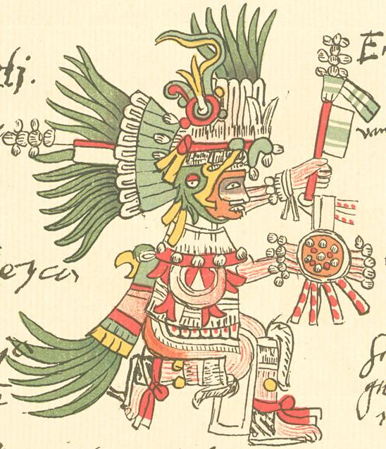
Tlacaelel took charge of a rewriting of the Mexica story, casting them as the chosen people of Huitzilopochtli. It is likely that, up until the rise of the Mexica to dominance in the Valley in the 1430s, Huitzilopochtli had only been their tribal god. Now he was elevated to the top of the pantheon of all the gods of all the altepetls incorporated into what has come to be called the Aztec Empire. Huitzilopochtli became the representation of (and justification for) the now-dominant Mexica's military success and its achieved identity as masters of what is now central Mexico. His choosing the Azteca of Aztlán as His people, renaming them Mexica and leading them on a long pilgrimage to their true destination and destiny was sacred history.
Nevertheless, in spite of all the challenges presented by these codices, it is thanks to them that we know as much as we do about Nahua culture and history prior to the Conquest, especially that of the Mexica.
Legendary Origins of the Azteca/Mexica
The Codex Aubin, bearing a Gregorian date in the 1550s, repeats and expands the pictographic history of the Codex Boturini, but also adds a narrative written in Nahuatl script. To the great fortune of English speakers, a project at Fordham University (New York City) has translated much of the Nahuatl into English, making its narrative available to such persons as us.
According to these two early codices, in the latter half of the 12th century CE, the Azteca migrated from a homeland they called Aztlán (the origin of the name Aztec(a), an island in a lake, or surrounded on three sides by a river, some unknown distance to the northwest of the present Mexico City.
Other codici give much earlier dates for the exodus, a hundred years earlier. The Anales de Tlatelolco give the day and year of the exit from Aztlán as "4 Cuauhtli" (month of Four Eagle) of the year "1 Tecpatl" (Flint), which correlates to January 4, 1065. Chimalpain, in his Eight Accounts and the Memory of Culhuacán, also dates the Azteca migration a hundred years earlier, in 1064 CE. Such is the nature of legends that merge into what we know as recorded history.
When the exodus occurred — and whether or not Aztlán was an actual, specific location — is debated by scholars. Most probably, it relates to some area that is now in the southwestern U.S. or northwestern Mexico. This is evident because Nahuatl is a member of what is known as the Uto-Aztecan language family, a number of members of which existed — and still exist — in that area. They include Ute, Comanche, Shoshoni and Hopi, as well as the languages of some native tribes in what is now California.

The initial scene in the Codex Boturini
shows the Azteca leaving the island Aztlán.
Around the temple on the island are six capulli, houses,
i.e. clans composing the tribe.
The year glyph in the center is 1 Flint, 1164 CE.
|
| The initial scene in the Codex Boturini shows the Azteca leaving the island Aztlán. Around the temple on the island are six capulli, houses, i.e. clans composing the tribe. The year glyph in the center is 1 Flint, 1164 CE. |
In Colhuacán they also encounter the god Huitzilopochtli, Humming Bird of the South (portrayed in the drawing as a head hanging inside a cave). He tells them he has adopted them as his people and will lead them to a new home.
Shortly afterward, the Azteca and the other eight tribes arrive at a place called Tlatzallan Texcaltepetzallan. There, at the order of Huitzilopochtli, the Azteca announce to the other tribes that they are leaving them behind and going ahead on their own. This is represented by a drawing of a tree that suddenly, miraculously splits. Subsequently, they reach a place called Cuextecatl, where Huitzilopochtli announces to them, "Your name is longer 'Azteca'. You are now the 'Mexica.'
According to the Boturini and Aubin codices, the Mexica then spent nearly thirty years wandering southeastwards, arriving at the city of Tollan in 1196 (Aubin Codex) or 1201 (Boturni Codex), where for the first time, they settle for a number of years (19 according to the Boturini, 20 according to the Aubin). Tollan had been the center of the Tolteca Empire, dominating the area that is now south-central Mexico after the decline of Teotihuacan (around 600 CE), from 900 to about 1150 CE. So, by the time the Mexica arrived about fifty years later, it was virtually abandoned. Its dramatic ruins are now a major archeological site, known as Tula, in the southwestern corner of the State of Hidalgo, about 45 miles northwest of Mexico City.
Shortly afterward, the Azteca and the other eight tribes arrive at a place called Tlatzallan Texcaltepetzallan. There, at the order of Huitzilopochtli, the Azteca announce to the other tribes that they are leaving them behind and going ahead on their own. This is represented by a drawing of a tree that suddenly, miraculously splits. Subsequently, they reach a place called Cuextecatl, where Huitzilopochtli announces to them, "Your name is longer 'Azteca'. You are now the 'Mexica.'
Reaching Tollan, the Threshold Between Legend and History
According to the Boturini and Aubin codices, the Mexica then spent nearly thirty years wandering southeastwards, arriving at the city of Tollan in 1196 (Aubin Codex) or 1201 (Boturni Codex), where for the first time, they settle for a number of years (19 according to the Boturini, 20 according to the Aubin). Tollan had been the center of the Tolteca Empire, dominating the area that is now south-central Mexico after the decline of Teotihuacan (around 600 CE), from 900 to about 1150 CE. So, by the time the Mexica arrived about fifty years later, it was virtually abandoned. Its dramatic ruins are now a major archeological site, known as Tula, in the southwestern corner of the State of Hidalgo, about 45 miles northwest of Mexico City.
 |
| The Mexica arrive in Tollan (represented by the glyph of reeds sprouting from water, holding a fish) in year 4 Calli (House or Clan) 1201 CE, and stay until 9 Acatl (Cane or Reed), 1219 CE. The sequence of nineteen years of name-number glyphs begins at lower left. It is read from bottom (4 House) (1201 CE) to the top (8 House), then down the second column from 9 Rabbit to 13 Rabbit, then up the third column from 1 Reed to 5 Reed, then from the top of the fourth column, 6 Flint, to 9 Reed (1219 CE). Boturni Codex |
Despite Tollan's state of ruin, the Mexica surmised or learned from people in the area of its importance and saw it as a model of the altepetl they hoped someday to found. Subsequently, when they did arrive in the Valley of Anahuac, they were to seek alliances with the residents of Culhuacán (also spelled Colhuacán), Tolteca who had settled in the Valley at the same time Tollan was beginning to rise to power in the 7th century. Establishing alliances with the Culhuas, the Tolteca of Culhuacán, via marriage and military support was a major way to establish a hereditary connection with that great culture and, hence, political legitimacy and status among the other peoples of the Valley.
Tollan was an abandoned place of the past when the Mexica arrived, but it was certainly an historical location and culture that had already had much influence on the history of the neighboring Valley of Anahuac, and, via its Culhua relatives, it would come to play a major role in the development of the history of the Mexica once they crossed the threshold from the Tula Valley into the Valley of Anahuac.
The Mexica left Tollan and spent a few years moving southward. According to the Boturini and Aubin codices, sometime between 1220 and 1240, they entered the north end of the Valley of Anahuac. It is important to realize that this entrance was not just a physical transition. It was also the beginning of a transition from a lifestyle of hunter-gatherer nomads into a world that was primarily agricultural, based on corn, and politically organized into hierarchically structured altepetls, city-states, with certain cities controlling various amounts of territory and their subsidiary villages around them. It was civilized.
Tollan was an abandoned place of the past when the Mexica arrived, but it was certainly an historical location and culture that had already had much influence on the history of the neighboring Valley of Anahuac, and, via its Culhua relatives, it would come to play a major role in the development of the history of the Mexica once they crossed the threshold from the Tula Valley into the Valley of Anahuac.
Entering the Valley of Anahuac and Joining the Tangled Threads of History
The Mexica left Tollan and spent a few years moving southward. According to the Boturini and Aubin codices, sometime between 1220 and 1240, they entered the north end of the Valley of Anahuac. It is important to realize that this entrance was not just a physical transition. It was also the beginning of a transition from a lifestyle of hunter-gatherer nomads into a world that was primarily agricultural, based on corn, and politically organized into hierarchically structured altepetls, city-states, with certain cities controlling various amounts of territory and their subsidiary villages around them. It was civilized.
 |
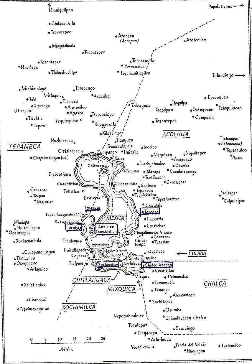
| Map of the Valley of Anahuac at the time of the Azteca/Mexica arrival in the 13th century. It shows major altepetls and other settlements in the Valley. Many are mentioned in the account that follows. The large island shown in the bay in the southwest of Lake Texcoco, where the Mexica were to establish Tenochtitlan, was not one large island. It was a group of islands they cobbled together using pilings and earth-fill, and crisscrossed by multiple canals, remains of the lake that had divided the islands. |
The Azteca apparently very quickly caught onto the political system and sought the earliest opportunity to establish a place for themselves within it rather than remain on the periphery as chichimecas ("barbarians") from the point of view of Valley residents and, thus, vulnerable to the powers that controlled the Valley. Their leader, Tozcuecuextli, soon established an alliance with the tlatoani, speaker, i.e. chief, of the altepetl of Tzampancgo (of Zampango as it is now known) via marriage to a princess named Tlaquilxochitzina. Tzampancgo was at the head of the northernmost of the five lakes in the Valley. Tzampancgo was actually subsidiary to the altepetl of Xaltocan, on the next lake to the south, which bore that name.
First Attempts to Establish a Recognized Settlement
The chronicles then add that the Mexica no longer lived primarily by hunting and gathering, but became stone cutters in the mountains around the Valley and construction workers in many of the other villages and altepetls in the valley. They also hired out as mercenary warriors for the frequent battles that took place between altepetls trying to expand their dominions. This established a military skill which was to come to be of central importance in their later development.
This second vocation, as mercenary warriors, proved immediately beneficial when, in 1245, a war broke out between an altepetl named Tenayocan (on the north shore of a bay on the southwest side of Lake Texcoco, the largest of the five) and the altepetl of Colhuacan (or Culhuacán, on the western end of the peninsula separating Lake Texcoco from Lake Xochimilco to its south). In or around 1250, the Mexica formed an alliance with Culhuacán, again, via marriage. This time a daughter of Tozcuecuextli, and Tlaquilxochitzina, named Azcaxotzin was married to a prince of Culhuacán named Acxocuauhtli. The chronicle goes on to say that a son named Coxcox (or Coxcoxtli) was born of this union and he would later become the tlatoani of Culhuacán. We will meet him later in that role, which proved to be a climatic one for the Mexica.
In 1272, Tozcuecuextli died and was succeeded by his son, Huitzilihuitl, who, in 1274, decided to found another village called Cuauhmixtitlan, on an island in Lake Texcoco. At this point, the Mexica allied themselves with the altepetl of Azcapotzalco on the nearby west shore of the Lake. Azcapotzalco was the primary altepetl of the Tepaneca people who controlled many other villages on the west side of the lake. Some scholars think Cuauhmixtitlan was founded on the same island that would become Tenochtitlan some fifty years later. In any case, it seems to have soon been abandoned or become a minor settlement, because the Mexica found a better place to live than a swampy island — and it was one the lords of Azcapotzalco did not control.
In 1281, the Mexica captured Chapultepec from a group of Tolteca, relatives of the Culhua of Culhuacán, far across the Lake. (So much for blood alliances!) Chapultepec was an area of shoreline centered around a small, extinct ash volcano with freshwater springs, on the west side of Lake Texcoco. Here, using the hilltop as a fortress, the Mexica settled. Huitzilihuitl was named tlatoani, "speaker" the official title of a ruler of a recognized altepetl. With this act, the Mexica were declaring their independence as a city-state, subject to none other in the Valley.
The independence of the Mexica as an altepetl at Chapultepec lasted only about twenty years, until 1299, when a group of other altepetls, Xaltocan, Colhuacan and Chalco (at the east end of the most southern of the lakes), apparently not liking the growing size and power of the Mexica at Chapultepec, attacked in one or two waves. The Mexica were overwhelmed. Huitzilihuitl and two daughters (he had no sons) were taken captive, first north to Xaltocan and then south to Culhuacán. There, they were sacrificed.
The remaining Mexica fled into the marshes around the lake but then, with no other option before them, went to Culhuacan to surrender and offer themselves as slaves in order to survive. The tlatoani of Culhuacán was none other than Coxcox, son of a Mexica mother and a nephew of Huitzilihuitl! Coxcox gave them an area of land called Tizaapan on the north shore of the peninsula to settle themselves.
This second vocation, as mercenary warriors, proved immediately beneficial when, in 1245, a war broke out between an altepetl named Tenayocan (on the north shore of a bay on the southwest side of Lake Texcoco, the largest of the five) and the altepetl of Colhuacan (or Culhuacán, on the western end of the peninsula separating Lake Texcoco from Lake Xochimilco to its south). In or around 1250, the Mexica formed an alliance with Culhuacán, again, via marriage. This time a daughter of Tozcuecuextli, and Tlaquilxochitzina, named Azcaxotzin was married to a prince of Culhuacán named Acxocuauhtli. The chronicle goes on to say that a son named Coxcox (or Coxcoxtli) was born of this union and he would later become the tlatoani of Culhuacán. We will meet him later in that role, which proved to be a climatic one for the Mexica.
In 1272, Tozcuecuextli died and was succeeded by his son, Huitzilihuitl, who, in 1274, decided to found another village called Cuauhmixtitlan, on an island in Lake Texcoco. At this point, the Mexica allied themselves with the altepetl of Azcapotzalco on the nearby west shore of the Lake. Azcapotzalco was the primary altepetl of the Tepaneca people who controlled many other villages on the west side of the lake. Some scholars think Cuauhmixtitlan was founded on the same island that would become Tenochtitlan some fifty years later. In any case, it seems to have soon been abandoned or become a minor settlement, because the Mexica found a better place to live than a swampy island — and it was one the lords of Azcapotzalco did not control.
In 1281, the Mexica captured Chapultepec from a group of Tolteca, relatives of the Culhua of Culhuacán, far across the Lake. (So much for blood alliances!) Chapultepec was an area of shoreline centered around a small, extinct ash volcano with freshwater springs, on the west side of Lake Texcoco. Here, using the hilltop as a fortress, the Mexica settled. Huitzilihuitl was named tlatoani, "speaker" the official title of a ruler of a recognized altepetl. With this act, the Mexica were declaring their independence as a city-state, subject to none other in the Valley.
The Plot Thickens
The independence of the Mexica as an altepetl at Chapultepec lasted only about twenty years, until 1299, when a group of other altepetls, Xaltocan, Colhuacan and Chalco (at the east end of the most southern of the lakes), apparently not liking the growing size and power of the Mexica at Chapultepec, attacked in one or two waves. The Mexica were overwhelmed. Huitzilihuitl and two daughters (he had no sons) were taken captive, first north to Xaltocan and then south to Culhuacán. There, they were sacrificed.
The remaining Mexica fled into the marshes around the lake but then, with no other option before them, went to Culhuacan to surrender and offer themselves as slaves in order to survive. The tlatoani of Culhuacán was none other than Coxcox, son of a Mexica mother and a nephew of Huitzilihuitl! Coxcox gave them an area of land called Tizaapan on the north shore of the peninsula to settle themselves.
 |
| Huitzilihuitl and his daughter Chimalaxoch are brought before Coxcoxtli of Culhuacan, to be sacrificed. Codex Boturini The year glyphs to the right, from top to bottom, read from 3 Técpatl (Flint) to 6 Ácatl (Reed). equating with the years 1300 to 1303. |
The Mexica and the Culhuas of Culhuacán
In 1303, the Colhuas went to war with the Xochimilca (a powerful altepetl that controlled the Valley on the south side of Lake Xochimilco).
MCA Note: What follows is excerpted from translations of Nahuatl of the Codex Aubin; the translation is a combination of one done by Fordham University in New York City and by us from a Spanish translation done by Patrick Johansson K. “La fundación de México-Tenochtitlan: El mito y la historia”, The Foundation of Mexico-Tenochtitlan: The Myth and the History,
The Colhuas began to lose, so Coxcoxtli said, "Have the Mexica left? Bring them here." So they called the Mexica and they came before the ruler of the Colhuas, who said to them, "Go to the Xochimilca, who are defeating us so far. You are to capture eight thousand Xochimilca, who will be your prisoners (hence, slaves)."
Then the Mexica said, "We will, O ruler. Please grant us at least a meager shield and a meager club."
The king answered, "I won't. You agree to go as you are."
The Mexica then began to consult with each other. "What will we take with us?" they said. We will cut off the noses of our enemies. Because if we cut their ears, people could say, "Maybe you cut them off from both sides. Let's not have that. Instead, let's cut off their noses and fill up sacks with them to count how many there will be."
Then the Mexica arrived at the edge of the settlement of the Xochimilca. The Mexica came back and their captives were counted before the ruler Coxcoxtli. The Mexica said, "O ruler, here are all our captives. We caught 32 thousand of them."
Then Coxcoxtli called for his advisors. He said to them, "The Mexica are not human. How did they do this to the Xochimilca? ... The deaths they're responsible for are a bad omen."
Only four of the Mexicas' captives remained alive, but they didn't let the ruler Coxcoxtli see that. (To celebrate) They set up an earthen altar there in Tizaapan, "Now O Ruler, give our earth altar a little something to adorn it."
Then the ruler said, "I will. You have done me a favor. I will have the priests go adorn it."
Here other accounts of this event differ widely as to what Cocox offered for the ritual. They say the Mexica asked for one of his daughters, whom he provided, thinking she would be an honored guest. Instead, the Mexica dressed her as one of their goddesses and sacrificed her, which was part of their customs. When Coxcox arrived and discovered this, he was, of course, enraged and drove the Mexica from Tizaapan.
The Codex Aubin gives a much less violent and more symbolic offense for the split between the Culhuas and the Mexica and places the blame on the Culhuas. It says that as gifts for the Mexica altar, in the night the priests brought piles of animal dung. The next morning, when the Mexica discovered this insult, conflict broke out between the two tribes and the Mexica were forced to flee.
,The Codex Aubin gives a much less violent and more symbolic offense for the split between the Culhuas and the Mexica and places the blame on the Culhuas. It says that as gifts for the Mexica altar, in the night the priests brought piles of animal dung. The next morning, when the Mexica discovered this insult, conflict broke out between the two tribes and the Mexica were forced to flee.
The Mexica Seek an Island of Their Own
Fleeing the Culhua, in 1303, the Mexica tried to settle first in Mexicaltzingo, not far north of Culhuacán, at the western end of the peninsula, possibly an island just offshore. The residents there forced them to move on. As most of the shores around all the lakes were already occupied and controlled by various Nahua tribes, the only remaining alternatives were a series of small islands in Lake Texcoco, to the north of the peninsula.
The Mexicas moved to a nearby island (later called Nextipac), and, according to the codices, remained there for four years. But the Culhuas attacked and burned the entire settlement, leaving no trace of it. The Mexica then moved on to Iztacalco, farther north in the lake, but were again forced by existing residents to keep moving.
Finally, in the year 1325 CE, they came to an island or set of uninhabited islands near the western shore that were under the control of the tlatoani, lord of Azcapotzalco. He granted them the right to establish their village there, which they named Tenochtitlan. In exchange, they became subjects of the lords of Azcapotzalco and mercenary warriors in its battles against other altepetls in the Valley. These included Culhuacan and Texcoco, the altepetl of the Alcolhuas who occupied the northeast side of Lake Texcoco. Defeating Culhuacan and Texcoco brought all of the area around Lake Texcoco under Tepaneca control.
In 1428, when there was an intrafamilial struggle for who would be the next tlatoani of Azcapotzalco, the Mexicas joined with the Alcolhuas of Texcoco and Tlalcopan, a Tepaneca village south of Azcapotzalco, forming the Triple Alliance against their rulers. They defeated them and quickly took control of the entire Valley. As the most powerful member of the Triple Alliance, the Mexica of Tenochtitlan became the dominant force, receiving the most tribute from subjugated altepetls in the Valley of Anahuac and then beyond. As such, they were the leaders of what historians have called the Aztec Empire.
 |
| The Valley of Anahuac at the time of its domination by the Mexica of Tenochtitlan. |
The End of an Empire
The "empire" would last less than one hundred years. In November 1519, Hernán Cortés, his Spanish troops and indigenous allies who opposed Azteca domination, crossed the mountain pass now named after Cortés and entered the Valley of Anahuac. Two years later, in August 1521, the Azteca Empire was overwhelmed by that of the Spanish. Tenochtitlan was replaced by la Ciudad de México, the City of Mexico and the Valley became the Valley of Mexico. The Aztec Empire, as well as lands far to its north and south, became Nueva España, New Spain.