Showing posts with label Moorish Revival. Show all posts

Tuesday, September 15, 2015

Colonia Condesa and Its Sisters - From Past to Present, Part I: Transition to the 1920's

In our last post, Seeking Restored Vitality, we reviewed the colonias, neighborhoods, established at the end of the Porfiriato, at the turn of the 19th to the 20th century. Our focus was on the question of what made for the varying degrees of success we have observed in restoring their century-old, shared heritage of stylish homes and in integrating them with all the changes they underwent in that one hundred-plus years. 

Our answer was that two things seem to have made the difference. First is their proximity to the major axis of Paseo de la Reforma with its dynamic fusion of the Mexican version of a 19th century European boulevard and pedestrian promenade with the skyscrapers of the contemporary global economy. Second is their having "good bones," public streets and parks inviting people to walk, sit and enjoy what is around them. We concluded that, among the colonias we have explored, Colonia Roma Norte, with its relative proximity to Reforma and its "good bones," was most successful in this endeavor.

End of the Porfiriato, Transition to a New Epoch


With that perspective, following the (mostly) charming Álvaro Óbregon Avenue west from Roma Norte, we cross Insurgentes Avenue and begin our amble through the last of the Porfirian colonias, the one known as Condesa. Actually, the area is comprised of four colonias, or parts thereof:
  • Condesa, 
  • Condesa Hipódromo (Condesa Racetrack), 
  • Hipódromo, and 
  • One part of Roma Norte that—located on the west side of Insurgentes—is physically more connected to Condesa than to its eastern side.
Gathering this group into one neighborhood are the major thoroughfares that mark its boundaries on four sides:
  • Chapúltepec Avenue to the north,
  • Insurgentes to the east,
  • Benjamin Franklin to the south, and 
  • José Vasconcelos to the west. 
Chapúltepec Woods is just to the northwest. We refer to all of them as "Condesa."

CLICK to enlarge any photo.
A gallery of all photos will appear below it.

During the Colonial period, the land was a hacienda, a large estate, owned by a series of countesses, hence the name. The original mansion still stands on José Vasconcelos Avenue, in the southwest corner of Condesa Hipódromo. The U.S.S.R. Embassy throughout much of the 20th century, it is today the Russian Embassy surrounded by a high wall, which makes picture-taking a problem, even worse than the modern U.S. Embassy on Reforma.

In 1902, the owners decided to subdivide the hacienda into residential properties. The northern section was developed first as part of Roma. To the south, the Mexican Jockey Club opened a racetrack in 1910. In the 1920's, after the Revolution, it was closed, and the land was divided into residential lots.

destacada
Hipódromo of JockeyClub of Mexico as it was being converted into residential buildings in 1920s.
Larger, outer ring is Amsterdam Ave.
Photo: MXCity

The shape of the racetrack, however, was preserved, which accounts for the oval shape of Parque México and Amsterdam Avenue, which circles it, and for the name of that colonia, Hipódromo. We will find that this difference between pre- and post-Revolution origins in development of the colonias is reflected in their architecture.

The Two Hearts of Condesa

So let's begin with Condesa's "bones" and, extending the metaphor, its vital organs. Álvaro Óbregon leads us to a lovely, tranquil park virtually at the colonia's heart, Parque España.

Parque España 


From this serene core, wide spokes of tree-lined streets with shaded camellones, medians, spread out to the north, west and south.

Two short blocks to the southeast is Condesa's larger, and more active heart, Parque México. 

Art Deco clock points to the new architectural era in which the colonia developed

We will come back to Parque México, but first, let's stroll out some of the spokes, the "bones" radiating from Parque España.

The Bones of Condesa


Tuning north from where Avenida Álvaro Óbergon touches the park, we walk up Avenida Oaxaca. through what is actually part of Roma Norte.


Avenida Oaxaca is one of the few avenues in Mexico City with a row of palm trees

Along the way, we pass some old acquaintances:

Neocolonial home, now a restaurant


Amidst admittedly non-descript contemporary buildings, we have our first ecounter with a new, post-Revolution esthetic:

1930s-40s Art Deco

Oaxaca leads to a large traffic circle with a monumental statue at its center:

Fountain of Cibeles 

The Neoclassic Fountain of Cibeles [Anatolian earth goddess adopted by the Greeks and Romans] is an exact replica of one erected in Madrid, Spain, in the late 18th century. The copy, a gift of friendship from Spanish residents in Mexico City, but echoing the Colonial past, was installed here in 1980. The plaza around the statue was recently renovated and replanted with flowering plants.

Around the outside of the traffic circle are more Neocolonial and Neoclassic buildings. Housing cafes, restaurants and other shops preserve the Porfirian European ambience.


Continuing up Oaxaca to where it meets Insurgentes and Chapúltepec Avenues at the huge glorieta, traffic circle, we encounter other vestiges of the Porfiriato. They are, however, rather more down-on-their-luck than those around the Fountain of the Cibeles.


Second French Empire buildings on Insurgentes


Neoclassic mansion
(Sign indicates that current commercial tenant uses side entrance)

Reversing direction and heading back to the Cibeles Fountain, we angle southwest from Oaxaca and enter Calle [Street] Durango, the first of a chain of broad, shaded boulevards forming a semi-circle along the west side of Condesa, a kind of "ribcage" around the colonia's double hearts.

Camellón, pedestrian meridian down Calle Durango

And running north and south of Durango, on side streets named after Mexican cities such as Valladolid and Salamanca ...


...a quiet blend of tradition and definitely upscale, contemporary urban life.

Crossing Another Threshold

When Durango intersects with the wide Calle Veracruz, it bends more to the south and becomes Avenida Mazatlán. 

Neoclassic mansion at intersection of Durango, Veracruz and Tampico

Here we say goodbye to Roma Norte and enter Colonia Condesa proper.  We also find that we have crossed another threshhold, leaving behind the Neoclassic and Neocolonial of the earlier established La Roma for ...


... that nostalgic, eclectic hybrid we have met in other Porfirian colonias, California Colonial, with its spiral columns and ornate dooways. The architecture tells us that we have entered a neighborhood established in the 1920's and 30's.


But then there appears a 1930's apartment building adopting formal Neoclassic elements. 


Followed by more 1920's fantasy:

Medieval mixed with California Colonial, and
Moorish Revival


As Mazatlán approaches the southern limit of Colonia Condesa at Avenida Michoacán, we find ouselves moving into an area of predominately utilitarian, unimaginative Post-World War II construction, where the ornamentations of pre-war fantasies are left behind.

Seeking to uncover more of the early 20th century "dreamed city" in Condesa, we turn northeast, up Michoacán, and walk towards its heart, Parque México, and our next post.

Other Posts on the Porfiriato Era


Delegación Cuauhtémoc
The "Porfirian" colonias line the west side of Delegación Cuauhtémoc
From north to south they are:
Santa Maria la Ribera (violet)
San Rafael (medium pink)
Cuauhtémoc, (medium blue triangle)

South of Paseo de la Reforma
Benito Juárez (horizontal triangle of three adjacent pink sections)
Roma Norte (light blue) (Doctores, to the east, is a separate colonia)
Roma Sur (darker blue)

And to the southwest (lower left):
Condesa (medium pink)
Condesa Hípódromo (dark pink)
Hípódromo (pale pink)

Centro, and its five sub-divisions (Historico, north, east, south, west)
 is to the right center (almost white)

Sunday, July 5, 2015

Colonia Santa María la Ribera: Early 20th Century Century Potpourri

Colonia Santa María la Ribera (St. Mary of the Shore) is a neighborhood located in the Delegación Cuauhtémoc (borough) of Mexico City, west of the Centro Historico. It lies north of the main avenue Ribera San Cosme, which follows the path of the Aztec causeway that originally connected Tenochtitlán with the western shore of Lake Texcoco. It sits on the former lake bed; hence the name, Ribera (shoreline).

It reminds me of a mixture of Greenwich Village and the Lower East Side in the 1960s, the Left Bank of Paris, and my grandparent's Victorian house, along with a touch of World's Fair.

French Second Empire-style homes,
with characteristic mansard roofs..
All Photos: JRB

click on any photo to enlarge it;
a gallery of all photos will appear below it.

The neighborhood was created during the Porfiriato, the rule of Porfirio Díaz, at the end of the 19th century for the affluent who wanted homes outside of the then city limits. The architecture of its oldest homes reflects that era's love of everything European, and especially French.

Restored neo-colonial style home,
now condo apartments.

Neo-classic building,
now apartments

The colonia reached its height between 1910 and 1930. 

Cerrada Chopo-Pino, Poplar-Pine Alley,
a delightful block of two-story town houses.
Could be Greenwhich Village or Brooklyn Heights

After the Mexican Revolution, in the 1930s, new residents moved in and another era of construction began.

California colonial,
distinguished by decoration around the door, 

round arch windows and spiral pillars
Style imported from California in the 1930's.

The colonia began to deteriorate in the 1950s, as the city grew rapidly around it and low-income apartment buildings were constructed.

Post WW II apartment building

Today, la colonia es una mezcla, is a mixture of old mansions and homes—over 1,000 categorized as having architectural or historic value—, small shops and businesses, tenements, abandoned buildings and new apartments. As a whole, the neighborhood conveys a complex, sometimes deteriorated past, but it also conveys the vitality of revival, reuse and regeneration that is typically Mexican.

¨"Juices"


Wall with window and door. That's all that's left.

Work-in-progress, maybe


Like a jewel and oasis, at the center of the colonia lies the Alameda de Santa María la Ribera, a park which features, believe it or not, a Moorish pavilion at its center. 

Moorish Pavilion

The Moorish Kiosk or Pavilion, built of wrought iron, was the Mexico Pavilion for the 1884 New Orleans World Cotton Centennial and then the Louisiana Purchase Exposition (aka St. Louis World's Fair) in 1904.

Mexican Pavilion at the World Cotton Centennial
Wikipedia

Returned to Mexico, it was first installed in the Alameda Central park. but then moved to Santa María la Ribera when Porfirio Díaz had the Hemiciclo to Benito Juárez monument built for the 1910 commemoration of Mexican Independence.


With its circles of thin pillars holding the mass of its intricately carved walls suspended above, and a delicate net of light falling from its glass cupola, it is a wonderfully fanciful space that carries the visitor's imagination to some distant, past world.

But why something Moorish to represent Mexico to the world—or at least to its progressively oriented neighbor to the north? A mystery, but the Spanish brought many Moorish esthetics to Nueva España. Also, Moorish Revival architecture was the fashion in Europe and North America at the turn of the 19th to 20th century. 

On the west side of the Alameda stands a completely different esthetic. The Geology Institute was built at the direction of President Díaz as one of the many projects to celebrate the 100th Anniversary in 1910 of the beginnng of the Mexican War of Idependence. Like the Palacio de Comunicaciones in Centro Historico, it is neo-classic, but on a much smaller scale. 


Entering, you encounter one of those soaring, wrought iron, double staircases, like those in the Palacio de Correos and the Palacio de Comunicaciones, that Díaz, or his architects, apparently loved so much. Rather than the dramatic angles of the staircase in the Correos, this one is all flowing curves. 


Passing under the staircase, you enter the center hall, dominated by a fossilized American mastodon. Very 19th century wooden cabinets line the walls, displaying various minerals. 


At the far end of the room, a curious stained glass window portrays the Wieliczka Salt Mine in Poland. Why a Polish salt mine in Mexico? Another mystery yet to be solved. 

The Wieliczka Salt Mine functioned for over 700 years,
from the 13th century to the 21st.


Detail: Love the horse, and the cobalt blue boots!

As if Moorish Revival next to Neo-classic weren't enough of a contrast, a few blocks southeast of the Alameda is another building from the same turn of the century era, but with a completely different esthetic.


The Museo Chopo is an art nouveau structure whose esthetic combines fantasy with turn of the century, cutting-edge steel and glass technology. A kind of cathedral to technology, it was built in 1902 in Germany for an industrial exposition. At the end of the exposition, a Mexican company bought it, hoping to display industrial machinery and erected it on Calle Chopo [Poplar St.] in Santa María la Ribera. Those plans didn't work out, so it became the Natural History Museum. Neglected, it was closed in 1964 and nearly dismantled.

Fortunately, in the 1970's, a new Law of Artistic and Historic Monuments required that it be protected. In 1977, it was reopened as the Chopo Museum, operated by the National Autonomous University of Mexico (UNAM). Completely renovated again in 2009, the museum hosts cutting-edge contemporary art exhibits. When we visited, Gay Art was the featured exhibit.


So all in all, and in its own unique way, Santa María la Ribera, is very Mexico City in its mezcla of architectural styles, from Neo-colonial and Neo-classic to French Empire, Moorish Revival, Art Nouveau and California Colonial, as well more modern interlopers. Es un popurrí, una mezcolanza, un batiburrillo mexicano. Una fiesta arquitectónica.


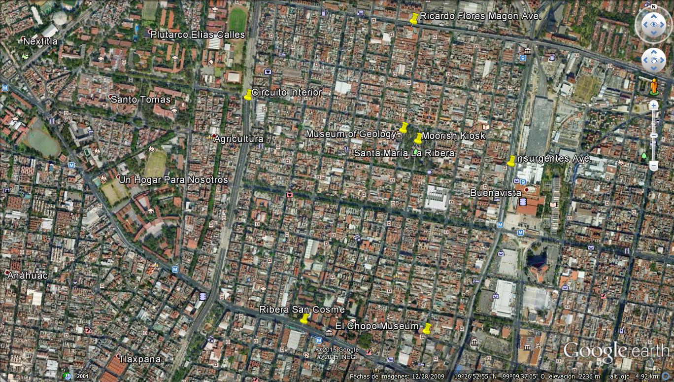
Santa Maria la Ribera is bounded on
the north by Avenue Ricardo Flores Magon,
the east by Insurgentes Ave.,
the south by Ribera San Cosme,
the west by Circuito Interior,


Delegación Cuauhtémoc
The "Porfirian" colonias line the west side of Delegación Cuauhtémoc
From north to south they are:
Santa Maria la Ribera (violet)
San Rafael (medium pink)
Cuauhtémoc, (medium blue triangle)

South of Paseo de la Reforma
Benito Juárez (horizontal triangle of three adjacent pink sections)
Roma Norte (light blue) (Doctores, to the east, is a separate colonia)
Roma Sur (darker blue)

And to the southwest (lower left):
Condesa (medium pink)
Condesa Hípódromo (dark pink)
Hípódromo (pale pink)

Centro, and its five sub-divisions (Historico, north, east, south, west)
 is to the right center (almost white)