Showing posts with label Mexico City boroughs. Show all posts

Friday, August 5, 2016

Mexico City's Original Villages-Coyoacán: The Lord of Compassion Visits Barrios San Lucas and Niño Jesús, the Child Jesus

Barrio San Lucas, St. Luke's: Where tradition and modernity rub against one another.

Sunday is not a day on which we hurry to get up. It is, after all, supposed to be the Day of Rest. So on the second Sunday in June, we arrive late at the Barrio San Lucas, St. Luke, to meet el Señor de la Misericordia, the Lord of Compassion, on his continuing series of visitas to the pueblos originarios in la Delegación Coyoacán. San Lucas, which is walking distance from our apartment, just across División del Norte boulevard, is a small barrio of winding, one-lane callejas or callejuelas, side streets.

Sadly, when we arrive, el Señor de la Misericordia is already there.


How we wish we had seen his llegada, arrival, from Barrio San Francisco, on this wonderful canoe, covered with mums! We hadn't attended his arrival, a week ago, in Barrio San Francisco, just south of Villa Coyoacán, as we had friends visiting.

El Señor is already in his place inside the church. Mass is being celebrated. 

The Lord of Compassion, seated in St. Luke's Church,
this time in a sky-blue robe,
again surrounded by hundreds of flowers: roses and lilies.

Outside, la fiesta, the party, has already begun.

The community gathers.
Original chapel is at the rear.

The current church of San Lucas was built in the mid-20th century. However, the original, small chapel, constructed some time in the 16th century, still stands to one side of the new church, at the rear of a small atrio.  I ask a member of the fiesta organizing committee, identifiable by his pink polo shirt, if the chapel is ever open. He says it is open on St. Luke's feast day, in mid-October, and for special occasions such as weddings and baptisms. So we know we will have to mark the autumn date for a return visit.

Fiesta committee member, Alfonso Reyes, his daughter and wife.
Note image of el Señor de la Misericordia on his shirt.

Compañeros, buddies


Some other caballeros, gentlemen, offer us a libation of tequila. The Franciscan friar, Bernardino de Sahagún describes in his Historia General de las Cosas de Nueva España, 'The General History of the Things of New Spain', how an alcoholic drink, pulque, a beer of fermented agave juice, which is now distilled into mescal and tequila, was a part of indigenous fiestas. We decline, politely making the excuse that at this time of day it would put us to sleep. They laugh in a manner muy amable, very kind.

When I ask if they are from San Lucas, one says he is from Barrio San Francisco, which brought el Señor here today. Another is from Barrio San Mateo, St. Matthew, which is right next door to us in Parque San Andrés. We tell him we are neighbors and will be sure to attend the barrio's fiesta in September.

Señor from Barrio San Mateo


Y las señoras, the ladies


Muchas señoras, many ladys, at least those not attending mass, are sitting, awaiting the serving of la comida, the afternoon meal, another tradition of fiestas. 


We note that there don't seem to be many children and few young adults, and we wonder why. San Lucas nonetheless appears to be a barrio with many modern, more upscale Mexican homes, although their gated street facades are so simple that they blend in with older houses,

One joven, young man, in the gathering

Two Cultures 


As we leave, we notice a sign hanging on a house directly across from the church. It advises "anyone interested in buying or renting in San Lucas" to first acquaint themselves "with the barrio's customs," in order to respect them. It is a sign of an encounter, if not a clash, between two Mexican cultures: traditional pueblo-based and globalized modern.

It reminds us of articles we have read in the Mexico City press about el pueblo, the people of traditional barrios, resenting the arrival of high-rise apartments and their residents, with their mascotas consentidas, pampered pet dogs, big cars and lack of respect for traditonal ways. In turn, the apartment dwellers resenting the noise of cohetes, the rocket-like firecrackers that announce fiestas and frighten their dogs.

Nos preguntamos. We wonder. In San Lucas, there are no high-rise apartment buildings like the one we live in in Parque San Andrés, only two-story houses. High-rises are evidently not allowed. But there is a tension between old and new. The fiesta says that the traditional is still alive, but the sign says there is a lucha, a struggle going on in el barrio, even if it is a virtually invisible one.

Barrio Niño Jesús: More Co-habitation of Tradition and Modernity

Because we missed El Señor's colorful arrival and animated reception in Barrio San Lucas the previous Sunday, we make sure to get to the meeting place for his arrival in Barrio Niño Jesús, Child Jesus, plenty early. We have passed its picturesque entrance arch many times while riding by on Avenida Miguel Ángel de Quevedo, but have never entered the neighborhood.


When we arrive at the arch, some residents of the barrio are waiting. 

The lady in bright pink shirt tells me she looks forward to the visit of el Señor every year.

Encuentro de los santos, Meeting of the Saints


En un rato, in a little while, we hear the explosions of cohetes, announcing the arrival of a procession. 


From within the barrio, the procession emerges, bearing its patron saint, el Niño Jesús, the Child Jesus.

"Welcome, Lord"

Different from San Lucas, youth are among those accompanying the saint. Young women are the bearers of the palanquin.


Soon, we hear other cohetes coming from the north. ¡El Señor llega!, the Lord arrives!


El Señor arrives, accompanied by members of San Lucas. The members of el Niño Jesús parish carry their saint across the wide avenue, stopping traffic, in order to welcome their sacred guest.

Papier maché figures of chinelos,
Moorish-like dancers, accompany el Señor,
once again, with hundreds of fresh roses and lillies.

Long Live el pueblo


El mayordomo, the head of the committee from Niño Jesús, calls out greetings:

"¡Viva el Señor de la Misericordia!
¡Viva San Lucas!
¡Viva el Niño Jesús!

Los feligreses, the faithful, from both parishes echo each "¡Viva!", "Long live...!" As saints are, by definition, eternal, we wonder why the wish for long life. Then we realize, the cheer is for each barrio, each pueblo, itself, for the long life of its people and its traditions, for the continuation of its identity.


¡Bienvenida! - Welcome!


With el Señor leading the way, the two saints and their followers enter el Barrio del Niño Jesús.

Iglesia del Niño Jesús

A couple of short blocks down a narrow calleja, we all arrive at the church. The priest comes out to receive the saints and el pueblo, the people

The priest is a friar, member of an order, either Franciscan or Dominican.

To applause, el Señor is carried into his new hospedaje, lodgings, for the week

And, after mass, la comida comunal, the communal meal.

Among the diners, at right,
we recognize the man in the yellow and purple shirt and red cap and his son with the dinosaur,
from Pueblo Tres Reyes.

Afterwards, we amble around the barrio to get a better sense of it. 

Narrow callejas
characterize the barrio
Virgin of Guadalupe
watches over another approach
to the church. 


Modern, upper-middle class homes and new, multi-story construction

At the end of one calleja, we even ecounter a guard house, protecting the entrance to a gated community of homes. Later, in a newspaper, we see ads for rentals and purchases of apartments, condominiums and houses in what is obviously presented as an ideally private, tranquil neighborhood near the center of historic, de moda, fashionable Villa Coyoacán.

So, like San Lucas, Niño Jesús, is a combination of traditional pueblo and contemporary upper-middle class urban Mexican life. And the Lord of Compassion is still welcomed and honored. 

We think of the priest, receiving El Señor at the door of the church. The Franciscans, then the Dominicans and other Catholic religious orders, arrived in Mexico in the early 16th century to undertake the Spiritual Conquest. It looks like they were successful.

Barrio San Lucas: Upper-right star
Barrio Niño Jesús: Lower-left star
Villa Coyoacán: Purple colonia west of San Lucas
Parque San Andrés: gold "arrowhead"-shaped colonia just east of San Lucas

See also:
Mexico City's Original Villages: Introduction - Landmarks of the Spiritual Conquest
The Spiritual Conquest: The Franciscans - Where It All Began
Mexico City's Original Villages: Coyoacán's Many Pueblos
Coyoacán: Pueblo of Tres Santos Reyes and the Lord of Compassion
Coyoacán: The Lord of Compassion Goes Visiting
Coyoacán: Pueblo Candelaria Welcomes the Lord of Compassion
Coyoacán: The Lord of Compassion Travels from San Pablo Tepetlapa to Santa Úrsula Coapa  
Coyoacán: The Lord of Compassion Returns Home to Pueblo Tres Santos Reyes    
Coyoacán: San Mateo Churubusco - Identity Via Church and Market

Monday, July 18, 2016

Mexico City's Original Villages: Coyoacán's Many Pueblos

Es fácil traducir esta página en español: vaya a la columna a la derecha. En la parte más alta hay una ventana etiquetada "Translate". Desplace la flecha abajo hasta encuentra "Spanish". Click en ese y inmediatamente todo el texto estará traducido en español por Google. Con certeza, habrá errores, pero creemos qué el sentido se quede bastante claro.
We started Mexico City Ambles exploring the City's physical and historic Center, Colonial Centro Histórico. Then we moved on to explore the expansion of the City, beginning with the transition from Spanish colony to Mexican Independence (1821) and passing through the 19th century, with its vestiges of the volatile epoch of the Reform (1857-1876), the prosperity of the Porfiriato (1876-1911), with its initiation of many European-style, upper-class colonias, and arriving, lastly, at the Revolution (1911-1917), with its abundance of public art produced by the Mural Movement.

Having come up almost to contemporary times, our interest took a turn back to the beginnings of Mexico City and its development from the original Mexica city of Tenochititlan and the many altepetls, city-states, and pueblos that existed around Lake Texcoco. We discovered and explored the four original barrios or parcialidades of San Juan Tenochtitlan that still exist, almost hidden, in Centro Histórico. Now we find ourselves ready to return to our home base of Coyoacán and begin to explore its pueblos originarios.

We live in Colonia Parque San Andrés, St. Andrew's Park, an upper-middle-class, residential neighborhood of modern private homes, townhouse complexes and small apartment buildings, in Delegación Coyoacán, the borough of Coyoacán, Place of the Coyotes, about five miles south of the Zócalo in Centro Histórico, Delegación Cuauhtémoc.

Coyoacán is the deep purple, trapezoid-shaped delegación,
in the virtual geographic center of the City
just south of Benito Juárez, which is south of Cuauhtémoc,
the location of Centro Histórico.

1,800-Year-Old Village


Fountain of the Coyotes, in Jardin de los Centenarios, Garden of the Centenarians,
Villa Coyoacán

Before the arrival of the Spanish in 1519, the historic center of Coyoacán, named Villa Coyoacán by Hernán Cortés, about a mile west of Parque San Andrés, was an indigenous village with a long and complex history.

Archeological investigations have found remains of an initial settlement from around the year 200 CE. It is thought that before that time, Lake Xochimilco and Texcoco were larger and water covered this part of the valley. The settlement was a short distance east of the Villa in the location of what is now the Chapel of the Concepcion, built on Cortés' orders in 1521. It is now el Barrio Concepción. It is likely it was built by the first people to establish agriculturally-based settlements in the Valley, the Otomí, who had domesticated the cultivation of corn in the Balza River Valley just over the mountains to the east (now in the State of Puebla). Hunter-gatherer tribes had been in the Valley since at least 9,000 years ago.

In the 7th century CE. this settlement was considerably enlarged, likely having been taken over by Tolteca, the earliest Nahuatl-speaking tribe to enter the Valley they called Anahuac. Earlier in that century, they had first taken over a pre-existing village on the peninsula separating Lake Xochimilco, to the south, from Lake Texcoco to the north. They named their settlement Culhuacán, The Place of the Old Ones. They subsequently took over the settlement in Concepcion, across the narrow channel connecting the two lakes, giving them control of that waterway. For five hundred years, they maintained the settlement. In the mid 12th century, this site was abandoned for unknown reasons, which is curious, as the Toltecas, based in Culhuacán remained a major power in the valley until the 14th century.  

Meanwhile, around the year 1000 CE, another Nahuatl-speaking tribe, the Tepaneca, entered the Valley and, over time, took over the Otomí villages on the west side of Lake Texcoco, establishing their main city at Atzcapotzalco (now within the delegación of that name at the northern end of the City). By 1350, they had pushed south into what had been Tolteca territory. West of the abandoned la Concepción site, they built a larger village where the present Villa Coyoacán is located. It is possible they gave it the Nahuatl name of Coyoacán. 
Information from an article, Evidencias arqueologícas en el Centro de Coyoacán, Archeological Evidence in the Center of Coyoacán, in the magazine Arqueología mexicana, issue of Sept.Oct. 2014, pp. 43-48.
The Tepanecas of Atzcapotzalco and the Toltecas of Culhaucán, based on opposite sides of Lake Texcoco, were to remain competing powers until another Nahuatl-speaking tribe entered the Valley in 1225 and, over a two-hundred-year period, were eventually able to gain sufficient strength to challenge both.

These were the Mexica (aka Azteca), the last of the Nahuatl speaking tribes to arrive in the Valley. Over a period of one hundred years, they attempted alliances with various of the existing altepetls around the five lakes, including with the Toltecas. For a couple of decades at the end of the 13th century, they were able to maintain their own altepetl on the hill called Chapultepec, Then they were forced to become subjects, first, briefly, of the Tolteca of Culhuacán and then of the Tepaneca of Atzcapotzalco. The Tepaneca allowed them to finally obtained their own land, a set of islands in Lake Texcoco. There they founded their own altepetl, Tenochtitlan in 1325. As subjects of the Tepaneca, they helped them conquer the Toltecas of Culhuacán in 1385.
For a more detaiedl history of the entrance of the Mexica to the Valley and their two-hundred-year-long, circuitous rise to power, see our post: San Juanico Nextipac: Stepping Stone to History.
Over the next forty years, the Mexica became powerful enough that, along with allies from other altepetls (called the Triple Alliance), in 1428 they overthrew the Tepanecas and became lords of the entire Valley. Coyoacán came under their control. They expanded the city to an even greater size, as their main base of power and trade in the southwest of the Valley.

Scoring ring from ball court,
unearthed next to Church of San Juan Bautista,
Villa Coyoacán

The Mexica also built a causeway, now the Calzada de Tlalpan highway, south across the Lake from Tenochtitlan, creating branches at the entrance to the channel to Lake Xochimilco: the west branch ran to Coyoacán; the east branch to the peninsula they called Iztapalapa.

Major villages around the five lakes of the Valley
at the time the Spanish arrived in 1519

Transformation into a Spanish Village

As one of the main entrances to Tenochtitlan, via the causeway, Coyoacán held a strategic position. On the Noche Triste, Night of Sadness June 30, 1520, after the Spanish massacred Mexica priests and leaders and their tlatoani, ruler, Moctezuma was subsequently killed, Cortés and his troops had to flee from Tenochtitlan west to Tlacopan. They returned to the Valley in the spring of 1521, and Cortés gained the support of Coyoacán's Tepanec tlatoani to give him access to the causeway in order to attack the Mexica city. 

After Cortés conquered the city in August 1521, he then set up his headquarters in what he named Villa Coyoacán while the Mexica city was rebuilt into the Ciudad de México. As he had done upon landing on the mainland, establishing la Villa Rica de la Vera Cruz and having his troops elect him the equivalent of mayorin naming Coyoacán a "Villa", he was declaring it officially to be a Spanish village according to Spanish law, with rights to internal self-government by its Spanish residents (somewhat like an official village in the U.S.) and to direct appeal to the king. This was his way of claiming independence from the governor of Cuba, who had charged him with an exploration of the mainland coast, not to land and attempt to conquer it. He thereupon bypassed the governor of Cuba and communicated directly with King Charles, reporting his victories and seeking royal approval. 

Because of  Cortés choice of Coyoacán as his initial official seat of power, the earliest Spanish Colonial government buildings and churches in Mexico City and Mexico are here. (The earliest Spanish settlement on the continent had been established in 1510 in Panama).


Coyoacán after the Spanish Conquest
(here spelled Coyohuacán)
and surrounding settlements with original indigenous names,
and convents and churches established by Franciscans and Dominicans.

The dashed blue line to the east shows the location of the shore of Lake Texcoco in the 16th century.
The locations of original indigenous settlements and roadways (in red) 
are overlaid on the streets of modern Coyoacán, (in white).
The north-south roadway at far right was the causeway that crossed Lake Texcoco.

This map is the first we have seen giving original names we have not previously found
 of some of the indigenous pueblos,
many of which are no longer used.

From La evangelización del área coyoacanense en el siglo XVI,
The Evangelization of the Area of Coyoacán in the 16th Century, by Jaime Abundis
from Arqueología mexicana, Sept.-Oct 2014 issue,

Ayuntamiento, "City Hall"initially constructed by Hernán Cortés in 1521is the first Spanish government building in Mexico.

Chapel of the Immaculate Conception, 
"La Conchita", "The Little Shell".
Hernán Cortés had the first Catholic chapel erected here in 1521,
on an indigenous temple site,

 making it one of the first Catholic churches in the continental Americas. 
Subsequently, it was assigned to the Franciscans.
The structure was rebuilt in the late 17th century
with a Baroque facade.
Recently restored.

Church of San Juan Bautista, St. John the Baptist, Villa Coyoacán.
Original church built in the mid-16th century by the Dominicans.

Chapel of Santa Catarina
Site of original building erected by Dominicans in 16th century,
the current chapel was erected around 1650.

Originally, it was an indigenous settlement called Omac.

Transition to Modernity

During the Spanish Colonial period (1521-1821), the area remained one of scattered villages in the rural countryside. In 1857, during the Reform Era under President Benito Juárez, it was incorporated into the Federal District (now Mexico City). During the Porfiriato Era of the late 19th century, Villa Coyoacán and its original, adjacent colonias of Concepción and Santa Catrina, along with Del Carmen, built during the Porfiriato, became the site of "country homes" for wealthy city residents.

Frida Kahlo's family lived in the neo-colonial Casa Azul, Blue House, in Del Carmen. The house in which Leon Trotsky was assassinated is a couple of blocks north.

Garden of Frida Kahlo's Caza Azul, Blue House.

The delegación was created in 1928, when the Federal District was divided into sixteen boroughs. However, the urban sprawl of Mexico City did not reach the borough until the mid-20th century, turning farms and the former lakebed into developed areas (Wikipedia).

Today, the colonias of Villa Coyoacán, Concepción, Santa Catrina and Del Carmen retain much of their Spanish Colonial and early 20th-century Neo-colonial architecture and constitute a charming, upscale, tourist-filled neighborhood where chilangos (city residents) and tourists take a weekend break from the bullicio, the hustle and bustle, of the modern city. We frequently have Sunday brunch in one of its many restaurants.

Francisco Sosa Street,
lined with Colonial homes.
The design on the facade is Spanish Moorish.

The street was originally the indigenous pathway west 
to the village of Tenantitla, which is now Spanish Colonial San Ángel.

Many Coyoacáns

There are, however, other Coyoacáns. The Delegación encompasses twenty square miles, almost the size of Manhattan. It is divided into ninety-seven colonias of widely varying sizes. The Colonial-period and Porfiriato neighborhoods occupy only the northwest corner.

Delegación of Coyoacán
Calzada de Tlalpan divides it from north to south.
Avenida Miguel Ángel de Quevedo runs west to east.

In the northwest corner are
Villa Coyoacán (lavender-pink) 
and its adjacent colonias of 
 Concepción (gold), Santa Catarina (purple), and
Del Carmen (large, yellow-tan), 
The Calzada de Tlalpan, which crossed Lake Texcoco, touched land in what is now Barrio San Diego Churubusco (light blue ). The Spanish extended it south to the villages of Tlalpan and Xochimilco. It now divides the Delegación in half. Avenida Miguel Ángel de Quevedo and its extension on the east side of Calzada Tlalpan, Calzada Taxqueña, runs west to east.

  • East of the Calzada de Tlalpan was originally the channel connecting Lake Texcoco with Lake Xochimilco to the south. The former lakebed is now filled with late 20th-century housing and commercial shopping centers (think Home Depot and Walmart), which have replaced the indigenous chinampas ("floating gardens") of the lake and, after the Spanish drained the lake, Spanish haciendas (large estates for raising cattle or wheat).
  • The Far Eastern side of the Delegación was originally part of the peninsula of Iztapalapa and site of Culhuacán. It is now Pueblo San Francisco Culhuacan, divided into four barrios, and historically and still functionally connected to what is now Pueblo Culhuacan in Delegación Iztapalapa. We will explore both Culhuacans when we move on to Iztapalapa. 
  • The Southwest area was mostly scantily inhabited lava beds, pedregal (stony ground), created when, between 150 and 200 CE, the volcano Xitle buried the Otomi city of Cuicuilco. Dating from about 800 BCE, it was probably the earliest urban center in the Valley of Mexico. It was likely inhabited by Otomí people, the earliest known tribe to establish settlements based on corn agriculture in the Valley. The residents fled to the site that was to become Culhuacan and to Teotihuacan, the major Mesoamerican city in the north of the Valley. Part of the pedregal is now the site of the Ciudad Universitaria, University City, of the National Autonomous University of Mexico, UNAM. The rest is composed of two colonias, Ajusco and Santo Domingo, that were established by squatters in the 1960s and 70s when the city's population exploded from migrants coming from rural parts of Mexico. (See our page: How Mexico City Grew From and Island Into a Metropolis.)

Cuicuilco's Round "Pyramid"

Pueblos originarios

Running along the west side of the Calzada, north and south of Avenida Miguel Ángel de Quevedo (named after a mid-20th century architect and promoter of urban reforestation), and along the south side of Miguel Ángel, opposite Villa Coyoacán and its companion colonias, is yet another Coyoacán, a cluster of pueblos and barrios that were indigenous settlements long before the Spanish arrived.


Along the Calzada, north of Miguel Ángel, they are:
  • Barrio San Diego Churubusco (its indigenous name was Huitzilolpocho, originally an island under the control of Culhuacán, not Coyoacán)
  • Barrio San Mateo Churubusco (the southern part of Huitzilpochoco);
  • Barrio San Lucas (its indigenous name was Quiahuac)
West to east along Miguel Ángel
  • Barrio de San Francisco (its indigenous name was Hueytitlan);
  • Barrio de Niño Jesús (its indigenous name was Tehuitzco);
  • Pueblo de los Santos Reyes (its indigenous name was Hueytitlac).
Along the Calzada, south of Miguel Ángel
  • Pueblo de la Candelaria (its indigenous name seems to be unclear. We have read that it was called Tlanalapa or Tlanancleca; however, the rear side of its entrance arch says it was called Chinampan (area of chinampas, man-made islands in the lake) Macuitlapilco.
  • Pueblo de San Pablo Tepetlapa;
  • Pueblo de Santa Ursula Coapa.
These barrios and pueblos are among the one hundred and fifty pueblos originarios, original villages recognized by the Mexico City government. As such, they are living continuations of the Spiritual Conquest carried out by the Franciscans and members of other monastic orders. It is to them that we direct our next series of ambles.

See also:
Mexico City's Original Villages: Introduction - Landmarks of the Spiritual Conquest
The Spiritual Conquest: The Franciscans - Where It All Began
Coyoacán: Pueblo of Tres Santos Reyes and the Lord of Compassion
Coyoacán: The Lord of Compassion Goes Visiting
Coyoacán: The Lord of Compassion Visits Barrios San Lucas and Niño Jesús, the Child Jesus 
Coyoacán: Pueblo Candelaria Welcomes the Lord of Compassion 
Coyoacán: The Lord of Compassion Travels from San Pablo Tepetlapa to Santa Úrsula Coapa
Coyoacán: The Lord of Compassion Returns Home to Pueblo Tres Santos Reyes 
Coyoacán: San Mateo Churubusco - Identity Via Church and Market
Saturday, February 21, 2015

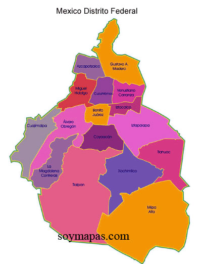
Mexico City Delegaciones: Sixteen Puzzle Pieces

Mexico City is shaped rather like a lumpy pear. Skinny at the top, it even has a "stem", then rounds out into a very fat bottom. It is divided into sixteen delegaciones, or boroughs, of greatly varying sizes, shapes, population densities and histories.

Mexico City's sixteen delegaciones (boroughs)

The Historic Center of the city is in the northern, skinny part, in the delegación of Cuauhtémoc. It is where the Mexica/Aztec city of Tenochtitlán was located on an island in the middle of Lake Texcoco. Other indigenous city-states or altepetls lined the lake shore, including Azcapotzalco, Tlacopan, Coyoacán, Culhuacan and Xochimilco.


Tenochtitlán, with Templo Mayor
Volcanoes Iztaccíhuatl and Popocatépetl form the eastern horizon

Painting in Museum of the City of Mexico

In 1521, after Hernán Cortés and his indigenous allies defeated the Aztecs, the Spanish leveled the indigenous city and began constructing Mexico City. 

"House of the Blue Tiles",
in Centro Histórico.
Palace built in late 1700's
by the Count del Valle de Orizaba
Although the Spanish soon began draining the lakes to reduce flooding in the summer rainy season, the city remained pretty much confined to the island until the 20th century. 

The other indigenous towns were developed as separate Spanish colonial towns, where the wealthy peninsulares (born in Spain) and criollos (Spanish born in the New World) established country homes and haciendas, rather like the estates built by Boston Brahmins on Newport Island and in the Berkshires, and wealthy New Yorkers built along the Hudson. 

Valley of Mexico, mid-19th century, by José María Velasco
Mexico City lies in the distance, middle left.
Volcanoes Iztaccíhuatl and Popocatépetl form the eastern horizon.


In the 19th and 20th centuries, the Federal Government gradually incorporated the outlying towns and the surrounding mountains to the south and west into what was then known as the Federal District [January 2016, Mexico City officially became its own governmental entity]. 

During the Porfiriato, the continuous presidency of Porfirio Díaz from 1876 to 1911, stylish suburban colonias or neighborhoods of large homes, such as Santa María RiberaSan Rafael and Roma were built for the new, wealthy industrial and commercial class on drained lake bed to the west and south of the city center. After the Mexican Revolution, in the 1920's and 1930's, additional neighborhoods, like Condesa were developed. Not until after World War II did the city´s growth explode—ingesting, amoeba-like—all these outlying settlements.

Thus, contemporary Mexico City is an amalgam, a crazy quilt or a collage of barrios and colonias from many centuries and cultural epochs, with their varying architectural styles. Some, such as Azcapotzalco, Iztacalco, Iztapalapa, Coyoacán, Tlalpan, Xochimilco and Tláhuac, as indicated by their indigenous names, have historic cores going back more than seven centuries, and some buildings, often Spanish colonial churches, that go back four or five.

San Juan Bautista, St. John the Baptist church,
in Coyoacán
built by Franciscan monks in the 1520's.


Others, including the colonias of Santa Maria Ribera, San Rafael, and Roma in Delegación Cuauhtémoc, are Parisian-style enclaves from the turn-of-the-19th to 20th century. 

Palacial home in Roma Norte
converted to apartments


Yet other delegaciones, like Benito Juárez, which fills part of the old lake bed, or Miguel Hidalgo and Álvaro Obregon that expand to the northwest and southwest, are Post-War modern. 

Modern home in Benito Juárez


And in the plains and mountains to the south and west, in the delegaciones of Tlalpan, Milpa Alta, Tláhuac, Xochimilco, Magdalena Contreras and Cuajimalpa, there are pueblos (traditional villages) where nopal cactus, vegetables and flowers are grown to supply "the city", where men wear cowboy hats and ride horses, and patron saint fiestas are celebrated as they are in "las provincias" (the other states), just as they have been since Spanish Catholicism was merged with indigenous religions.


"Chinelo" dancers, from the Nahuatl word “zineloquie”, “disguised"
The costumes reflect the Moors, driven out of Spain.
Dances of the Moors were brought by Spanish friars to Colonial Nueva España
to show the indigenous "heathen" the need to convert to Catholicism,
but they were turned by the indigenous into means for mocking the Spanish.
Candelaria Fiesta (Feb. 2, mid-winter)
in the pueblo of Santa Maria Magdelena Petlacalco,
on the side of Ajusco Mountain
in Delegación Tlalpan

It is interesting to note the two sets of names used to identify delegaciones: nahuatl (Aztec) for those with roots in native histories, in contrast with those named after the leaders of Mexico's development as an independent nation. This distinction reflects a three-way divide between Mexico's indigenous culture, Spanish colonial culture and alternating post-Independence efforts to distance from these conflictual pasts or try to synthesize them into a national "Mexican" identity.

This struggle is embodied in the name of delegación Magdalena Contreras, located in the "rural" western mountains. Combining the Spanish name of an indigenous pueblo, Magdalena Atlitic, with Contreras, a 20th century colonia of textile mills is one divide, but the double name, Magdalena Atlitic, presents another. Throughout Nueva España, as part of their intentional acculturation of the natives, Spanish friars gave Catholic saint names to the extant indigenous villages. Most retain these double names and identities; hence, Magdalena is the Spanish name, Atlitic is the Nahua.

Mexico City Ambles is a record of paseos, leisurely walks, spent exploring some of the colonias in this urban-rural, multi-cultural collage.