Showing posts with label Delegación Miguel Hidalgo. Show all posts

Saturday, June 10, 2017

Original Villages | Delegación Miguel Hidalgo: Tacubaya - Labyrinth Leading from the Present to the Past

In our effort to visit as many as possible of the original indigenous villages now incorporated into Mexico City, we have, for some time, wanted to visit Tacubaya, in a part of the Delegación Miguel Hidalgo that is to the south of Chapultepec Woods.

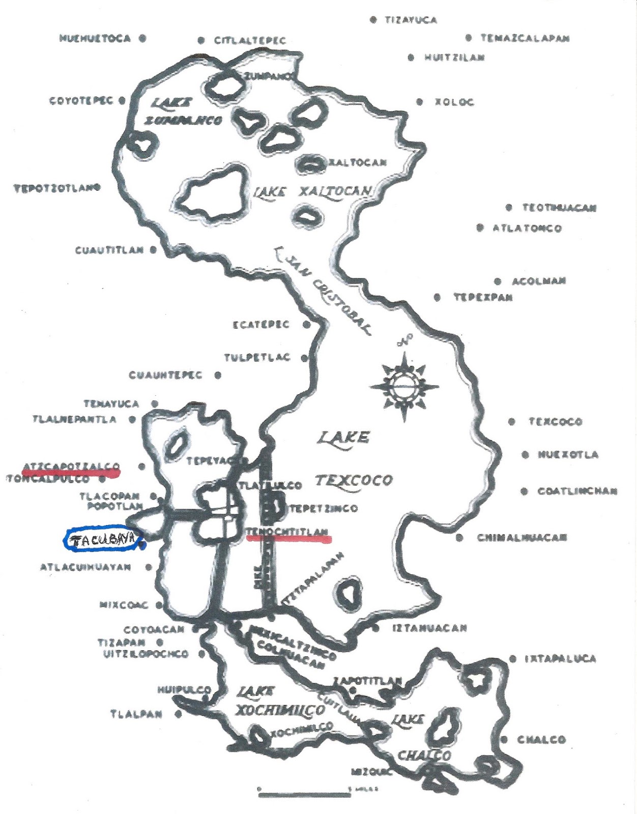
Tacubaya
lay on the southwest shore of Lake Texcoco.
Until 1428 it was under the control of the Tepanecs of A(t)zcapotzalco.
After the Mexica of Tenochtitlan defeated A(t)capotzalco,
it came under their control.

The area has been inhabited since the fifth century BCE. Archeological evidence shows continuous human habitation here since between 450 and 250 BCE by chichimecas, hunter-gatherer tribes. The Mexica tried to settle here in 1276 but then left in 1279. It was renamed Atlalcuihaya by the Mexica of Tenochtitlan when they took control in 1428, after defeating Azcapotzalco, which had dominated the west shore of Lake Texcoco. The name meant “where water is collected.” This name was Hispanicized to Tacubaya by the Spanish. Wikipedia

We had previously explored Tacuba, another original village north of Chapultepec. However, Tacubaya has a reputation for being a poor, unsafe area, so we were hesitant to go. Recently, on Facebook, there appeared an announcement of a tour of Tacubaya led by a chilango, Mexico City resident. Seeing this as our opportunity to go there with others, we called and made a reservation to join the tour. The following Sunday morning, we took our Line 2 of the Metro north to the Chabacano Station, where we changed to Line 9, which heads west and ends at Tacubaya

Finding Our Way Through Labyrinths


The Tacubaya station is a labyrinth of long tunnels and many stairways, as three lines cross there, the third being Line 7. We have been in the station before to view the wonderful murals by Guillermo Ceniceros portraying the gods of the Mexica and foundational legends of how in 1225 they came to arrive in the Valley of Anahuac, now the Valley of Mexico. 

Jade death mask of an indigenous king.
by Guillermo Ceniceros
Tacubaya Metro Station

Metro stations have good signage, directing travelers through the correspondencias, connections between one line and another. The leader of the tour has told us to meet him at "the exit to the Periferico (ring road expressway) from Line 1", so we follow the signs leading to Line 1. 

When we arrive in the area of Line 1, a large, two-story hall leading to multiple exits, we ask a policeman where the exit to the Periférico is. He seems puzzled but points us in a direction. Farther on, we ask a subway employee where the exit is in order to confirm we are on the correct path. Again, the person seems puzzled by our question, but points us in the same direction. 


We exit up some stairs and find ourselves near the entrance to a very large mercado, indoor market, that faces a large plaza mostly covered with concrete, yet containing a few trees, many free-standing puestos, merchant stalls, and a juego mecánico, carnival ride. We ask a couple of the puesto merchants if this is the exit to the Periférico. Again, they seem puzzled, but clearly thinking that we want to go there, indicate that the Periférico is on the other side of the mercado. 

It is a few minutes past 10:30, the appointed hour for the tour group to meet, but none of the people standing around the Metro entrance look to be candidates for such an adventure. They are mostly teenagers and adults hanging out on a Sunday morning. Not at all sure we are at the correct exit, but even more unsure about finding an alternative one, we call the tour leader's cell phone. There is no answer. We repeat the call several times over the next several minutes, with the same lack of result. 

Going It Alone Through a Labyrinth


Finally, we accept that we are on our own. Since we have made it to Tacubaya, we decide not to waste the trip and to seek out its historic buildings on our own. It is near noon on a Sunday, the safest time to wander about the city, as parents have the day off from work and take their familes out to church, one market or another, maybe to a museum (which are free on Sundays) or just for a paseo, stroll, though some plaza, park or along a tree-lined boulevard.

Our first destination is such a park, the Tacubaya Alameda, and a church likely to be having Mass, the Church of Nuestra Señora de la Purificación, Our Lady of the Purification. This Lady is the Virgin Mary at the moment of her purification forty days after the birth of Jesus, when she presents herself and the infant at the Temple in Jerusalem to be blessed by the priests. Her annual festival, on February 2, is Candelaria (because participants traditionally hold lighted candles), so the church is also better known as la Parroquia de la Candelaria, the Parish Church of Candelaria.

So we approach more merchants and ask directions to the Alameda and church. They point us along one of the multi-lane streets and highways that crisscross the area and tell us that, at a certain point, we will cross a pedestrian bridge. This leads us through what could only be described as another modern-day labyrinth. 

Puestos line an underpass beneath a major street.
This seems to be the "mens' wear" section.

Literally every centimeter of the way is lined with puestos, including an underground passageway. Tacubaya is certainly a good example of the muliple ways markets, broadly defined as any place where merchants and customers meet to sell and buy, are realized in Mexico City! 

Coming up from underground, we soon spot a pedestrian bridge over yet another multi-lane street. We confirm from a merchant that the bridge leads to the Alameda and the Church. 
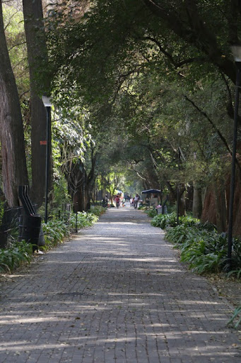
Tacubaya Alameda


Tacubaya Alameda

We soon arrive at the Alameda. The Wikipedia article on Tacubaya warns us that the park is "full of drug addicts, alcoholics and garbage", one of the reasons we were leery of coming to the area. But we don't spy any of the three plagues of urban parks (we are familiar with them; we lived in Manhattan in the 1970s). A policeman sits on his motorcycle eating a snack. Parents and children are taking a Sunday morning paseo. In one corner, a group is listening to an evangelical religious sermon. The sidewalks are in excellent condition and the traditional cast iron benches are freshly painted. These are all positive signs the park is currently being cared for by the government of the Delegación Miguel Hidalgo.

In the center is an obelisk honoring the Mártires de Tacubaya, the Martyrs of Tacubaya, soldiers who died fighting for the Reform government against conservative generals who had declared support for the Plan of Tacubaya, a rebellion against the new, liberal constitution of 1857. The generals used Tacubaya, then a village outside Mexico City, as the base for their uprising, which led to the so-called War of Reform (1857-1860). During the War, Benito Juárez became president in exile, returning to the City when the conservatives were defeated. 

Benito Juárez' triumphant re-entry into Mexico City,
January 1861
Juárez is the middle one of three men in black suits.
Painting in the National History Museum,
Chapultepec Castle

Walking through the Alameda, we come to the wide Avenida Revolución, a main north-south Eje, Axis road, and see the wall of the atrio, atrium, of the Church of Candelaria on the other side.

The Church of Candelaria  


Church of Nuestra Señora de la Purificación, Our Lady of the Purification,
aka Church of Candelaria

The atrio is a large, tree-filled, quiet retreat from the traffic noise of Avenida Revolución and the barullo, din, of the nearby mercado and ubiquitous puestos. It is one of those classic, tranquil Spanish Colonial spaces hidden within, and in total contrast to, the city around it. 

Church atrio

First Call


As we approach the church door, we hear a single toll of the church bell, followed by a series of tolls. A man standing to one side of the door is pulling a rope that leads upward to the bell tower. As he finishes, we comment, "First Call to Mass." He smiles and nods.  We had learned the system of bell tolls when we lived in Pátzcuaro, Michoacán, which has many churches, such that bells ring frequently every day of the week. 

Our Spanish teacher clarified that they are not marking clock time but are preparatory calls announcing a coming Mass. About twenty minutes before the service is scheduled to begin, a single toll of the bell announced First Call. Ten minutes later, Second Call begins (or depending on local custom, ends) with two tolls; then as Mass begins there is Third Call, initiated or ended with three tolls. All the tolling of the bell that takes place after or before the telltale toll(s) serves for nothing more than getting people's attention.

Sanctuary
As First Call to noon Mass has just been sounded,
only a few parishioners are present.
We especially love the azulejos, blue tiles of Islamic origin.

The sanctuary retains the simplicity of the early churches founded by the religious orders. Our Lady of the Purification is the only 16th century Dominican church remaining in Mexico City. The date 1590 is inscribed into the walls, and in the arches the names of the indigenous peoples who helped in its construction are inscribed: Tlacateco, Huitzilan, Nonohualco and Tezcacuac.

"Queen of the Holy Rosary, pray for us."
The Virgin Mary and the infant Jesus,
also in a simple artistic style.

Walking along one of the side aisles, we notice a door opening to the outside. Such doors usually lead the way to a patio or inner courtyard surrouded by a cloister, containing monks' rooms above and dining rooms and other common spaces below. Stepping over the threshold, we are not disappointed.


The rooms around the courtyard are still being used by the church, which is not always the case. During the Reform Period (1857-75) and after the Mexican Revolution (1910-1917), the cloisters were often taken over by the government as part of its effort to reduce the wealth and power of the Catholic Church. They were put to secular use. Now many are museums or government offices.

Another door leads from the patio out into a side street where we glimpse some interesting buildings.

Colonial Period or 19th century homes

Because of its natural beauty, during the Colonial period, the Spanish came to Tacubaya for respite from the City's Centro. Even after the Mexican War of Independence (1810-20), Tacubaya remained a popular getaway for the wealthy. Many of the well-to-do bought land here for second homes, making the area a summer-home suburb of Mexico City, similar to Mixcoac, Villa Coyoacán, San Ángel and Tlalpan to the south of the city. Across the side street from the church are two of the only such homes we have seen on our amble through what is now mostly a working class commercial area dominated by highways and puestos.

Returning to the front entrance of the church and passing again through its wonderful atrio, we step out onto Avenida Revolución and into all its modern barullo. Since our next destination is somewhere to the west of the mercado and Metro Station and the church is on the east side, we hail a taxi to avoid any attempt to wend our way on foot through the labyrinth of puestos and highways that lies between them. 

Museum of Cartography and the Convent of San José


When we tell the driver who stops for us where we want to go, the Museum of Cartography, he says he doesn't know where it is, but when we say it is at the corner of Avenida Observatorio and the Periférico, he replies, "Está bien"—"That's fine."

We make some turns and are soon on Observatorio, another multi-lane commercial street, heading west. Shortly, we see the two-level Periférico expressway crossing ahead of us. The driver stops and we get out.

In front of us is a very large, two-story building of Neo-classic style, obviously from the 19th century. Mexican Army soldiers are standing guard at the entry gate. We approach and ask if this is the Museum of Cartography, which we know is operated by the Army. They tell us, "No," it is the School of Military Studies. The Museum, they say pointing to an underpass below a Periférico entrance road, is just up Observatorio. Just then we see a sign identifying the museum, so we enter the tunnel.


Coming out of the tunnel, we see some stairs leading up to an ornate metal gate. Climbing the stairs, we come face to face with the museum.  Between us is a very attractive brick-paved atrio, but this one is not a peaceful refuge from the city. It is open to the two-level Periférico on one side and the entrance road on the other. Behind us is Avenida Observatorio. We have found a small island of the past in the midst of a contemporary urban sea.

A metal plaque on one side of the atrio tells us its story. Shortly after they arrived in the 1520s, the Franciscans established a "visiting" chapel in Tacubaya, where friars came weekly to administer the Sacraments and teach the indigenous people about Catholicism. This chapel was thus another outpost of the Spiritual Conquest. In 1590, a suborder of the Franciscans, the Order of San Diego, came and built the original convent. dedicated to San José, St. Joseph, Jesus' "godfather", the same saint to whom the first Franciscans who came to Nuevo España in the 1520s had dedicated their homebase convent in Centro. The "Diegans" were the same order that built the Convent of San Diego in Coyoacán, in what is now San Diego Churubusco. In 1686, the order built the church we see in front of us. Shortly afterwards, in the early 1700s, the convent was transferred to the Dominicans. 

Closed in the 19th century as part of the Reform expropriations, it was subsequently used by the Army and other government agencies, and even closed at various times. In 2000 the Secretariat of Defense, i.e., the Army, took it over to create the Museum of Cartography which displays many old maps of Mexico City, Mexico and the Caribbean region.

The former sanctuary has the simplicity of the Franciscan churches.

Returning to Avenida Observatorio, and having accomplished all of our goals of the day, we plan to take a cab back to the Metro, as we are tired and don't know how long a walk it would be. 

A Guide Out of the Labyrinth


As we walk by the School of Miliary Studies, one of the soldiers we had spoken to on our arrival calls out to us, "¿Comó se fue?"— "How'd it go?" "Muy bien", we call back. "Very well."

At that point, he comes out from the gated entrance and walks over to us. "Where are you going now?" "I'm catching a taxi to get to the Metro."

At my reply, he offers, "Oh, you don't have to do that. The taxi would have to make many turns and the Metro is just down the hill. See that yellow pedestrian bridge (about two blocks away)? Cross over and the mercado is just on the other side. The Metro is just beyond." 

We thank him mucho, adding that we had arrived at that Metro exit by the mercado. This soldier is another example of Mexican amabilidad, kindness, consideration, that we consistently meet on our Ambles around the city, and as we have in our journeys around the country. There is always someone ready and willing to help you out. There is always a guide to show you through whatever labyrinth you may feel you are in.

Delegación Miguel Hidalgo
is the dark brown area in the northwestern part of the city.
Just west of Cuauhtémoc, the location of Centro Historico.

Colonias of Delegación Miguel Hidalgo

Tacubaya (red and orange star)
is at the southern edge,
south of Chapultepec Woods (dark green area).


Tacubaya (green area)

Red/orange star in middle is the Mercado.

Green/yellow star to the right is Church of the Candelaria 
(acutally in another colonia).
The Alameda is to its left, across Ave. Revolución.

Mustard/yellow star, upper left, is Museum of Cartography.

Note how crisscrossed the colonia is with major highways and avenues,
making walking around it like a trip through a labyrinth.

Saturday, May 13, 2017

Green Spaces | Chapúltepec Woods: From Bustle to Tranquility, Present to Past


A Shift in Perspective


Up until now, our focus in Mexico City Ambles has been on how the cityscape embodies the city's long and complex history. We have concentrated on whole neighborhoods (called colonias, pueblos or barrios depending on their origins) and the buildings and other features that give them their unique character and identify their place in the development of the city's narrative. Where those features include plazas, parks or other forms of "green space", such as tree-lined boulevards, like Paseo de la Reforma, we have presented them, but we have not looked at them from a generic perspective.

Occasionally, we have written posts about generic qualities of the city, such as its efforts to communicate grandeza (grandeur)
, its Baroque and "California" Neo-colonial architecture, the range of markets and street commerce and the role of ritual in maintaining communal identity. So it occurred to us that looking at the city's wide variety of green spaces as a topic in and of itself would be not merely interesting, but perhaps even revealing of another aspect of the city's character. 

From that perspective, we reviewed the posts we have published over the past two years to see which included presentations of some form of green space: plazas, parks, boulevards, gardens, interior courtyards (patios). Only one, on Chapultepec Woods, the huge park west of Centro, is solely about such a space. However, a dozen or so other posts include such green spaces as a significant part of their urban character. The colonias developed during the Porfirato (dictatorship of Porfirio Díaz, 1876-1911) and the first decades after the Revolution (1911-17), such as La Roma and Condesa, sought to imitate Parisian elegance, including arboladas (tree-filled) plazas, parks and boulevards. 

Other colonias, such as Villa CoyoacánMixcoac and San Ángel, which have maintained their Spanish Colonial design, centered around central plazas and large church atrios (atriums), thereby also contain significant green space. Xochimilco, with its indigenous chinampas, man-made islands, and its evergreen-covered foothills, is particularly green. 

So we begin our new perspective on the City's green spaces, and a new series of posts, by republishing the one on Chapúltepec Woods.

Chapúltepec Woods


Two things drew us to the Bosque de Chapúltepec (Chapúltepec Woods): one was our ongoing search for a tranquil retreat within the bullicio, the bustle of the city. The other was to see how chilangos, Mexico City residents, spend their leisure time on a Sunday afternoon. Interestingly, we found that tranquillity and leisure time don't necessarily go together in Mexican culture.

Exiting the Chapúltepec Metro Station on Line 1, the Pink Line, on a sunny Sunday afternoon, we are caught up in a stream of families headed for the park. It is rush hour for relaxation. Typical of many Metro stations, the street level is thick wtih vendors selling food, caps, binoculars, bottled water and any number of other items. As elsewhere, we have to wend our way through this labyrinthian mercado to reach our destination.


Entering Chapúltepec Park

Inside, families are headed for a wide pedestrian bridge across a major expressway to enter the main part of the park. This promenade was originally the route of the Paseo de la Reforma which Emperor Maximilian had built during his brief and conflictual reign (1864-67) to connect his chosen residence, Chapúltepec Castle, with the city center, now the Centro Histórico, to the northeast. Reforma has been re-routed along the north side of the park and extended west to the city's boundary with the State of Mexico.


Chapúltepec Castle
above the Monument to the Niños Héroes, the Boy Heroes,
military cadets who fought to their deaths against U.S. forces
taking Mexico City in the Mexican-American, War 1847.


Paseo de la Reforma
seen from Chapúltepec Castle.
Six White Columns are the
Monument to the Boy Heroes
Photo by Carlos Cortés
Wikipedia


Family relaxing in the shade of the park's many trees.

The Bosque de Chapúltepec (Chapúltepec Woods) is one of the largest city parks in the Western Hemisphere, measuring in total just over 1,695 acres (686 hectares) (Central Park in New York City is half its size, with 843 acres, 341 hectares). The name "Chapúltepec" means "grasshopper hill" in Nahuatl and designates a volcanic formation called Chapúltepec Hill.


Aztec glyph of Chapúltepec,
in Capúltepec Castle

Perhaps the America's Oldest Continuously Used Park

The park area has been inhabited and held apart as special since the Mesoamerican era. Remains of Teotihuacan (500 BCE to 500 CE) and Toltec (800 to 1000 CE) cultures have been uncovered. When the Mexicas/Aztecs arrived in the Valley, then called Anáhuac, in the mid-thirteenth century, they settled here first, until they were kicked out by the Tepanec lord of Azcapotzalco, just to the north.

When the Mexicas/Aztecs became established in their island city of Tenochtitlán and defeated Azcapotzalco in the 15th century, they turned Chapultepec into a royal retreat. One notable site, of which there are some ruins, is the Baths of Moctezuma, a system of cisterns, reservoirs, canals and waterfalls. Because of its springs, the Mexicas built aqueducts across the saline lake to supply Tenochtitlán with fresh water. A temple sat atop Chapúltepec Hill.

After the Conquest in 1521, the Spanish King declared that it should remain a natural space for Spanish residents of the new city. It was not open to its original indigenous peoples or to any mestizo, mixed-race offspring of the two razas, races.

Fountain that marked the beginning of the aqueduct built by the Spanish
to carry fresh water from Chapúltepec's springs to the city on the island.

Today Chapúltepec is every chilango's backyard, one of the few constants in a city that has otherwise changed dramatically over nearly five centuries. Immediately to the west of the park, along Reforma, are the upper-middle class colonias, neighborhoods of Cuauhtémoc and Benito Juárez. To the south are La Roma and Condesa, the colonias developed at the end of the Porfiriato period (1876-1911) and after the Mexican Revolution. We have spent considerable time exploring and comparing them. To the northwest are wealthy colonias built in the mid-20th century: Polanco and the various Las Lomas, part of the Delegación, Borough, of Miguel Hidalgo, to which the park also belongs.

Today, the park is divided into three sections. The first section is the original. Still the most visited, it contains most of the park's attractions including a zoo, the Museum of Anthropology, the Rufino Tamayo Museum and the Museum of Modern Art along Reforma.  Chapúltepec Castle, about which we´ve written, now serves as the National History Museum (its website provides a virtual tour).

Un Paseo ... Stroll Through the Park

Following the crowd along the former Reforma, we turn right past the Monument to the Niños Héroes and come to a wide promenade, la Gran Avenida, Grand Avenue, an oval that circles through the first section of the park. In earlier days, carriages could be driven around it; later, automobiles traveled on it during Sunday drives, but today it is reserved for pedestrians. It is lined with puestos, stalls selling various kinds of souvenirs. 


3 T's for 150 pesos, about $9

Lucha Libre, Free Wrestling masks


Payaso, Street Clown

Farther along the Avenida, we come to Chapúltepec Lake, or is it Central Park Lake?


Past the lake is the Zoo. At this point, the park's ambience changes dramatically. The promenade of families reaches its destination and virtually disappears. Beyond this point lies the tranquility that we are seeking. The park becomes a quiet wooded retreat, an almost private space. La Gran Avenida becomes a path for a quiet stroll.

Tranquillity Amidst Millions


Yes, this is Mexico City with its 8 million people, in a metropolitan area of 21 million. By the way, when we visited it was December!

Friday, December 23, 2016

Mexico City's Original Villages | Miguel Hidalgo: Tacuba and The Roadway Where History Took a Fateful Turn

The Historic Roadway from Tenochtitlán to Tacuba


We began our series of ambles seeking out the Landmarks of the Spiritual Conquest, which identify the original indigenous villages from which Spanish Mexico City arose, by exploring what were the Four Original Indigenous Quarters of Tenochtitlán, now Centro. Cortés assigned them to his indigenous allies who had made the conquest of Tenochtitlán possible. Together, these four quarters were called San Juan Tenochtitlán.

When we explored the northwest quarter, Santa María Cuepopan, we discovered that the Church of San Hipólito stands at a most significant place in the history of the tumultuous change of Tenochtitlán to la Ciudad de México. It was here that Cortés and his men, attempting to flee Tenochtitlán on the night of June 30, 1520, were confronted by Mexica [meh-SHE-kuh] warriors.

San Hipólito sits at the intersection of Avenida Hidalgo,
which, to the west, becomes the Calzada México-Tacuba,
Ave. Balderas, which marks the western boundary of former Tenochtitlán,
and Paseo de la Reforma.


Night of Sorrows


On May 20, while Cortés was in Veracruz on the Gulf Coast, the Spanish had massacred Mexica priests at the Templo Mayor, then on June 26, the huey tlatoani (head speaker) Moctezuma Xocoyotzin (Moctezuma the Younger) had been killed in a confrontation between his Spanish captors and his own people. Cortés and his men were surrounded in the royal palace. In the dark of the night of June 30, they attempted to sneak out of the city.

Not surprisingly, they were caught in the act. Mexica warriors confronted them at the point where the roadway from Tenochtitlan to the important atepetl, city-state, of Tlacopan, on the west shore of Lake Texcoco, reached a moveable bridge and entered the causeway across the lake.

The Night of Sorrows - Library of Congress; Artist Unknown
Noche Triste, Night of Sorrows,
Artist unknown

Noche Triste
José Clemente Orozco

Tlacopan (now Tacuba)
was located on the west side of Lake Texcoco.
At the time of the arrival of the Mexicas in the Valley of Anahuac,
it was under the rule of A(t)zcapotzalco, just to their north.

On that fateful night, Cortés and his surviving troops, with the help of indigenous allies, managed to reach the western shore. It is legend that Cortés then collapsed beneath an ahuehuete tree and wept over his lost men. Ahuehuete means "old man of the waters" in Nahuatl. The trees, sacred to the indigenous, now carry the name Montezuma cypress.

All that remains of the trunk of the ahuehuete tree,
below which Cortés is said to have wept on the Noche Triste,
June 30-July 1, 1520.
The tree remained alive until the early 20th century.
Another Montezuma cypress,
planted some years ago, rises behind it.


The tree sits in a small plaza,

alongside the Calzada México-Tacuba,
about half way between Metro Stations Popotla and Cuitláhuac

Noche Triste
Cortés and his troops rest
on the lake shore at Tlacopan
José Clemente Orozco

Today that causeway is a major avenue, bearing several names as it extends west. Just west of San Hipólito, it is called Puente de Alvarado, Alvarado's Bridge, named after a lieutenant of Cortés who was thought to have been lost at the bridge. Subsequently, he made it to Tlacopan. The primary name of the street is the Calzada (literally, "footpath") México-TacubaLine 2, the Blue Line, of the Metro follows this ancient roadway from the Zócalo to Tacuba and beyond. So you can get there in about 15 minutes, for 5 pesos, US $0.25.

Tlacopan


The name of Tlacopan (place of the jarilla plant—same family as papaya) was converted by the Spanish into Tacuba. It is now a colonia in Delegación Miguel Hidalgo. When Cortés arrived in the Valley of Anahuac in 1519, its people were Nahuatl speaking Tepaneca. A hundred years earlier, it had been under the rule of the Tepanec atepetl of Azcapotzalco, just to its north.

However, in 1428, when the ruler of Azcapotzalco died and a power struggle erupted between possible replacements, Tenochtitlán and Texcoco, an atepetl on the east side of the Lake, decided it was their opportunity to ally against the city that dominated them. Tlacopan joined them against its overlords, thus becoming the third member of the Triple Alliance, which was to rule what is now Central Mexico for nearly one hundred years, until the arrival of the Spanish in 1519.

Tlacopan's importance led the Mexica to construct the causeway over the lake linking it with Tenochtitlán.  When Cortés and his surviving soldiers arrived via that causway to Tlacopan on July 1, 1520, in flight from Tenochtitlán, the rulers of Tlacopan rather than siding with their Mexica allies, chose instead to give shelter to the Spanish. They thereby opened the way for Cortés' retreat around the north end of the lakes and his return to Tlaxcala, the home of his major indigenous ally, over the mountains, east of the Valley.

There, Cortés was able to restore his troops and plan his ultimate attack on Tenochtitlán in the spring and summer of 1521. After the Spanish defeat of the Mexica in August of that year, Cortés granted Tlacopan/Tacuba to Isabel Moctezuma, a daughter of Moctezuma Xocoyotzin. In the first decades of the Colonial period, the village continued to be governed, for local purposes, by indigenous nobles, to whom Spanish names were given upon their baptism. One was Don Diego Cortés Chimalpopoca; another was Don Antonio Cortés Totoquihuaztli. The conqueror certainly left his mark.

Cortés. his soldiers and indigenous allies
defeat the Mexica of Tenochtitlan

Church of San Gabriel the Archangel


As they did in other cities and villages around the lakes of the Valley, the Franciscans came to Tlaopan, which they called Tacuba, built a mission church and dedicated it to the Archangel Gabriel who had announced to the Virgin Mary her pregnancy with the Son of God. The church was consecrated in 1566. In 1570, a convent or monastery was built and occupied by four friars, charged with converting and educating the people.

Church of San Gabriel Archangel, Tacuba

The site was within the prior sacred precinct of Tlacopan. The indigenous teocalli, house of god, was located on a low hill to the west of where the church was erected. In addition to stone quarried nearby, stones from the teocalli were used in building the church,

It served some fifteen settlements in the area. Like other convents, it had an orchard where figs, grapes, pears, apples, peaches, apricots and nuts were grown. It was significantly remodeled in the mid-18th century when the Archbishop of México took over the churches of the religious orders and made them parochial ones. Its original rectangular shape was enlarged into a cross.

Landmarks of the Conquest


While the church originally sat on the west side of a large plaza, it now sits in the midst of a sea of puestos, commercial stalls. Hence, getting to the building on a Sunday morning involves wending our way through a labyrinth of merchandise and foodstands.

As we have noted in our introduction to the Landmarks of the Spiritual Conquest, there are four primary such landmarks to identify an Original Indigenous Village: a church built in the early years of Nueva España, a government building, and a market—all centered around a plaza. One or another may be missing, most often a government building, as Mexico City´s government of neighborhoods has been centralized in the delegaciones, boroughs.

Former City Hall, in 1920s.
It and a glorietta, traffic circle,
have been replaced by the mercado
.
Photo: Wikipedia en español

Here in Tacuba, we learn that the former city hall, which governed the area before it was incorporated into Mexico City in the 1920s, was demolished in the 1960s. Initially, a plaza was recreated, but it has been taken over by a semi-formal mercado. What thus remains is a kind of face-to-face standoff between market and church.

Semi-permanent puestos, stalls have been erected
in what was once a plaza in front of San Gabriel.
Many of the trees remain.
The street is the Calzada México-Tacuba,
which runs to Centro Histórico, following the Mexica causeway.

Mexican menu (hanging above): 
Tacos are soft tortillas, folded and filled with various ingredients.
Huaraches are thick, long "sandal-shaped" tortillas covered with ingredients.
Gorditas are thick, round tortillas stuffed with ingredients.
Tostadas are thin, flat, crisp-fried tortillas 
covered with ingredients.

Entrance to the church atrio,
from the mercado, market

Main entrance
The overall simplicity reminds us of other Franciscan churches.
The stone portal is from the Baroque renovation in the mid-18th century.

Bas relief portraying the Annunciation to the Virgin Mary by the Archangel Gabriel
of her pregnancy with the Son of God
(Note the baby descending from God the Father in Heaven)

The sculpture is in Baroque style, added in the 18th century reconstruction.
At lower left is the date 1733, which may have been cut over an earlier date of 1573.

Main altar, from the Baroque period.
The spiral columns are "solomonic",
a style derived from ancient Greek columns 

incorporated into St. Peters Basilica.
(See our: California Colonial: From Emperor Constantine to Mexico via Spanish Baroque)
and Mexico Barroco

Oratorio, Prayer chapel
in the former convent,
to one side of the main sanctuary.

Church and Monastery of San Joaquín


About a mile southwest of San Gabriel and the center of Tacuba, down the wide, tree-lined Calzada de Legaria, is the Panteón Francés de San Joaquín, the French Cemetery of San Joaquín created in the 1940s.

Until the mid-19th century, when the Reform government of Benito Juárez seized much church property to try to eliminate the wealth and power of the Catholic Church, its many acres were the orchard of the Church and Convent of San Joaquín. It sat beside a river the Spanish also named San Joaquín, which flowed from the mountains to the northwest into Lake Texcoco. Like virtually all the rivers of the Valley of Mexico, it is now "entubed" and runs under Ave. San Joaquín, which passes by the south side of the cemetery. 

What remains of the complex, the church and part of the convent, sit in the northwest corner of the Panteón, behind a high wall. To find it, we have to walk from the current entrance to the Panteón on Legaria, around a corner past a children's hospítal, also on the former orchard grounds, and along narrow Calle Santa Cruz Cacalco bordered by the high stone wall enclosing the cemetery. Coming to a small, triangular plazuela, we find a small door open in the wall.

Church of San Joaquin

Stepping inside, we find ourselves in another of those marvelous oases of Spanish colonial tranquility. The church atrio is geometrically formal, with straight stone walkways crossing it at right angles, but softened by trees and some flowering plants in the squares between them. The church itself is constructed of stone and very rectangular.

Doors in the Atrio wall, leading to the street.
Only the small doors were open where we entered.

The Church and Monastery were built by the Carmelites in 1689. It was the eleventh Carmelite convent in Mexico. They had previously developed the Convent of San Ángel, now in the colonia of that name in Delegación Álvaro Obregon, which we have already visited. The San Ángel Church, like many churches in Mexico, was redone in the 18th century in florid Baroque style. Not so San Joaquín. It retains it orginal spare, almost severe, monastic simplicity.

Side door to the sanctuary.

As we hoped, on this Sunday morning, mass is being celebrated, so the church is open.


The interior is as spare as the exterior, all unplastered stone. The ceiling is also stone, but the dome is brick. Personally, perhaps because of our Protestant background, and maybe because of memories from long-ago visits to medieval Gothic cathedrals in Europe, we find the space very attractive, tranquil, conducive to meditation. 

Where Architectural Beauty Flows From Functional Demands


Mass is soon over, so after the parishioners leave, we go inside to examine the architecture more closely.

The Nave is covered by two intersecting barrel vaults,
forming a groin vault.

Piece de resistance:
To us, the dome, with its contrasting circles of black and red brick,
is a masterpiece of beauty created out of functional demands.

Enticed to See More and Invited to Return


As we are photographing and savoring the church's classic structure, we notice that a group of muscians who were playing for the mass are putting away their instruments in one side of the transept that crosses the nave below the dome. We greet them and comment on the unusual and strikingly simple aesthetic, so in contrast to Mexico City's predominantly Baroque churches, and we explain our mission of exploring and creating blog posts on those original churches and villages.

A woman, probably in her late forties, responds and asks if we would like to see the convent which is beside the church. This is beyond our expectations! We are delighted and express our appreciation for the offer. She leads us through a door in the transept. 

We enter what is clearly an old passageway, wide, with a high, beamed ceiling. We raise our camera, but she tells us that photos are not allowed. We have run into this invisible but unyielding barrier many times before in old Mexican buildings. Although we know from those past experiences that it will do no good, we ask,
"¿Por qúe?", "Why?" 
"Porque es patrimonio del país," she replies. "It is the patrimony of the country." 
Since she seems friendly and open, we venture to express that it seems a contradiction that what is explicitly being preserved as national heritage so it can be experienced by succeding generations of both citizens and foreigners is off-limits to photos, which are a means of sharing this richness with others who otherwise might never experience it. And it might even entice them to pay a visit. She nods in agreement.

She tells me that guided tours are given once a month, but she doesn't know the date. She offers to go find the priest to ask, and maybe, she implies, he might give an okay for me to take some photos. As we walk down the hallway, we pass an open door. She tells us that is the garden—that in fact, there are two gardens, but we cannot enter, as the church is about to be closed. 

We go in search of the priest, but discover he has already left. As we leave the atrio, our guide speaks to another of the musicians. He knows the phone number of the priest and writes it down for us. If we call, we can find out when the monthly tour takes place. And, maybe, we can get permission to take some photos. We hand the two musicians our card: "Mexico City Ambles, Paseos por la Ciudad de México", with our web address and email. 

Once again, our amble has led to wonderful surprises: an architectural and historical gem and still other muy amable mexicanas y mexicanos, very kind Mexican women and men who want to share those gems with us. We tell them that we certainly hope to be able to return to see the convent. After all, not only are we photographers and amateur historians of Mexico. We are also gardeners and the orchard of San Joaquín still exists, if only in cloistered, miniature form.

Delegación Miguel Hidalgo (brown)
is in the northwest section of the City,
It is just west of Delegación Cuauhtémoc,
location of Centro and former Tenochtitlan.

Delegación Miguel Hidalgo
Tacuba and San Gabriel Archangel are marked by green star, top center.
Church and Convent of San Joaquin
are marked by orange star,
to left, west

Much of the lower part of Miguel Hidalgo
is occupied by Chapultepec Woods
(dark green area).

Just to the west is the State of Mexico.
See also: