Showing posts with label Mexican history. Show all posts

Wednesday, December 8, 2021

Welcome to Mexico City Ambles: Navigating the Blog

Welcome to Mexico City Ambles! Here we seek to present "el imaginario", a vision of the city as embodied in its cityscape, public art and neighborhoods (pueblos and colonias). Over time, as we sought to discover the physical and historical breadth and depth of the City, our search led us to focus on the life of its lesser-known, working-class neighborhoods, many of which were indigenous pueblos existing long before the Spanish arrived and took over 500 years ago. We visit these original pueblos when they are celebrating their traditional fiestas, which are lively, colorful celebrations of their centuries-long communal continuity and unique identity.

¡Bienvenido a Paseos por la Ciudad de México! Aquí buscamos presentar el imaginario, una visión de la ciudad como encarnada en su paisaje urbano, arte público, pueblos y colonias. Si bien buscamos cubrir la amplitud y profundidad física e histórica de la ciudad, nos ha llevado a centrarnos en en la vida de sus pueblos y barrios menos conocidos, muchos de los cuales eran pueblos indígenas que existían mucho antes de que los españoles llegaron y se hicieron cargo desde 500 años. Visitamos estos pueblos originales cuando celebran sus fiestas tradicionales, que son celebraciones coloridas y animadas de su continuidad comunal por siglos y su identidad única.

Escribimos en inglés porque somos norteamericanos y para dar a conocer a otros norteamericanos y hablantes de inglés la ciudad más allá de los lugares turisticos típicos. Sin embargo, es fácil traducir una página en español: vaya a la columna a la derecha. En la parte más alta hay una ventana etiquetada "Translate". Desplace la flecha abajo hasta encuentra "Spanish". Click en ese y inmediatamente todo el texto estará traducido en español por Google. Con certeza, habrá varios errores, pero creemos qué el sentido se quede bastante claro.  

Organization of the Blog
  • Each post appears in the blog chronologically by publication date. 
  • Scrolling down from this introduction takes you to the most recently published post. 
  • Most posts, however, have thematic or geographic connections to other posts. 
  • So, as a navigation aid, we have created individual PAGES (listed in the left-hand column) which organize posts according to major aspects of the city or themes in its history. 
  • These pages provide short descriptions of posts, grouped according to a theme or by geography, with links to all relevant, individual posts.

Setting the Stage | Introductory Pages:


I. Making Sense of Mexico City: The first four pages acquaint you with Mexico City's organization (it does have one, despite its apparent chaotic appearance).
  1. First, we introduce you to its sixteen alcaldías (literally "mayoralties", each governed by an elected alcalde, mayor, and a council) into which the city is divided spatially and politically. 
    The name, alcaldía, was assigned recently, in 2016, when the self-governing legal entity of la Ciudad de México, Mexico City, was established. Initially created in 1928, they were called delegaciones (we use that term in our early posts). They were the components of el Distrito Federal, the Federal District, governed by the federal administration until 2000. The closest English equivalent for these divisions is "boroughs". Each one is distinctive in its physical characteristics, population, and history.

    2. We then address why Mexico City architecture appears to the visitor to be such a hodgepodge of historical epochs and we present a way to view it as a horizontal archeological site, one of multiple eras sitting right next to one another. 

    3. Then we present the history of how the city grew from a small, Spanish Colonial city on an island in the midst of a huge lake to its present huge size (at 573 sq. miles, slightly smaller than Houston [599] but bigger than Los Angeles [469]!). 

    4. Finally, we describe el Metro, the "subway", which is the fastest and cheapest pathway (US25 cents) to get to most of the places we explore. If you avoid morning and late afternoon rush hours, it's fine. Taxis, both pink and white "libres" cruising the streets and white "taxis de sitio" (i.e. waiting at a taxi stand), are licensed, plentiful and safe. Now Uber and other phone-ap car services are here. 

  • Mexico City's Sixteen AlcaldíasMexico City is shaped rather like a lumpy pear: skinny at the top—it even has a "stem"—then rounds out to a very fat bottom. Originally called the Federal District, in 1928, it was divided into sixteen delegaciones, or boroughs, of greatly varying sizes, shapes, population densities and histories. On January 1, 2016, via federal law, el Distrito Federal, the Federal District, officially became Mexico City and the delegaciones were renamed alcaldías, mayoralties.
  • Making Sense of Mexico City: Architectural Hodge-podge or Horizontal Archeological Site?Your first experience of Mexico City is likely one of an architectural hodge-podge, an incoherent batiburrillo, a jumble of buildings from various eras. This is especially true, if, as a tourist, you visit el Centro Historico, where Spanish conquistador, Hernán Cortez, began to build la Ciudad de México on top of the destroyed city of the indigenous Mexica (aka Aztecs), Tenochtitlan. Structures from the colonial period, adapted to contemporary uses, are enmeshed with newer neighbors from the 19th, 20th and 21st centuries. So what to make of this hodgepodge of eras, these fragments of disconnected history, this batiburrillo
  • How Mexico City Grew From an Island to a MetropolisHow did Mexico City, which started on an island in Lake Texcoco— replacing the Mexica (aka Azteca) altepetel (city-state) of Tenochtitlán—grow into the metropolis it is today, incorporating both ancient and new neighborhoods, side by side, all parts of the contemporary batiburrillo (hodgepodge)? Here is the story.
  • Mexico City Metro: The Mexico City Metro (officially, the Collective Transportation System) is a network of subway and surface electric train lines enabling chilangos (city residents' name for themselves) and visitors to get around the city quickly, cheaply (US25 cents) and safely. The system has 12 lines, each distinguished by a specific color on its signage, making changes from one line to another easy. There are also multitudes of taxis, both libre (cruising and painted pink and white) and de sitio (waiting at assigned locations and painted white) and yes, they are both safe. Now, of course, there are also Uber and other phone ap systems for calling a private chauffeur.

II. Mexico City's Natural Environment: The next set of pages acquaint you with the city's special natural environment: 
    • its year-round temperate, sunny climate, 
    • its history as a valley filled with large lakes, 
    • its spectacular geological setting in the midst of a circle of large, mostly dormant volcanoes, and 
    • its smaller, but historically important volcanoes within the city.
  • Mexico City Climate: Seasons, Sun, Sky, Clouds and Rain: If you are looking for a place to live year-round, permanently, as we do, or just to "winter" in Mexico, our advice is to head for the hills. The "hills" are comprised of the high plateau of Central Mexico known as el Bajío and the cross-country mountain chain just to its south, called the Eje Volcánico, the Volcanic Axis or Trans-Mexico Volcanic Belt. This area has year-round moderate temperatures because it is located more or less around 7,000 ft. above sea level, which keeps the climate quite stably moderate and usually sunny.
  • Mexico City sits at 7,000 ft. altitude. Here is our account of the City's mild climate: its seasons (there is no real winter), the sunshine (which occurs most days), the sky (which can be unbelievably blue), the clouds (which can be dramatic towering cumulus), and the rainy season, more or less from May to October. Don't worry, it doesn't rain every day and usually, it's in the late afternoon or after dark and consists of brief, at times intense, thunderstorms. They serve as natural airconditioning and air purifiers, keeping the summer air dry, the temperatures moderate during the day and cool at night and, usually, with clearer air.
  • City of Lost Lakes, Islands, and VillagesThe Valley of Mexico, now filled by urban sprawl, was originally nearly filled by a chain of five lakes (covering about 580 sq. miles). Lake Texcoco was the largest, most central, and lowest of them, thus receiving water from the other four. Because of the surrounding mountains, they had no outlet to the sea, and Texcoco was salty. The original Mexico City and its predecessor, Mexico Tenochtitlán, were on an island in a large bay in the southwest corner of Lake Texcoco. In addition, there were hundreds of villages that occupied the land around the lakes, as well as many on islands in the lakes.
    Over the centuries, the lakes have been almost totally erased since the Spanish began draining them in the 17th century to prevent the annual flooding of Mexico City during the summer rainy season, so the islands eventually became part of the mainland. We have been searching out these "lost" islands, which are still-existing pueblo neighborhoods within the city. Here we introduce the ones we have visited and the history of the changes they have undergone from islands to urban neighborhoods.

    Five original lakes of the Valley
    with some of the major cities and villages
    around them and on their islands.
    Note Tenochtitlan's location 
    at the entrance to a bay 
    in the southwest of Lake Texcoco.

  • Encountering Mexico City's Many Volcanoes, Part I: Giants on All Sides: Mexico City, as most everyone knows, sits in and takes up most of the Valley of Mexico. It is, in fact, a spectacular valley because it is surrounded by tall mountains, all of them volcanoes. 
    • Only one, Popocatepetl, (The Smoking Mountain), the tallest at nearly 18,000 ft (more than 10,000 feet above the Valley floor) is active, regularly emitting a plume of steam and sometimes erupting with huge columns of ash and lava. 
    • Popo, as he is familiarly called, is joined by his beloved frozen princess, Iztaccihuatl (The White or Sleeping Woman), at 17,000 ft. 
    • However, they are only the tallest and most dramatic members of the ring of volcanoes that surround the Valley. Here is an introduction to the many giants that envelop the city and make its geographic setting unique.
To the left is Iztaccihuatl
To the right is Popocatepetl
(as seen from Alcaldía Coyocán; they are forty to fifty miles southeast)
  • Encountering Mexico City's Many Volcanoes, Part II: Little Volcanoes With Big Histories: While the huge volcanoes of Popocatépetl, IztaccíhuatlAjusco and the others in the Cordillera de Chichinautzin, the Sierra de las Cruces and the Sierra del Río Frío, which create and dominate the Valley of Mexico and grab the interest of residents and visitors when they are in clear view, there are other volcanoes right within the city´s limits. They are small ash cone volcanoes, but despite their diminutive size, at least four of them have played prominent roles in the development of human settlements in the Valley and thus in the history of Mexico City. Here is our introduction to the four.
Cerro de la Estrella, Hill of the Star
Called Huizachtecatl (in Náhuatl) by the Mexicas.
  • Mexico City Architecture: This group of pages focuses on the architectural qualities which predominate, particularly in the Cento Historico of the city, the original Ciudad de México which Hernán Cortés began to build on top of the indigenous altepetl, México-Tenochtitlan of the Mexica.
  • Grandeza Mexicana: Grandeur of Mexico CityWalking the streets of Mexico City, from its Centro Histórico to various of its late 19th to early 20th century colonias, (planned neighborhoods) and modern boulevards, acquainting ourselves with their architecture and public art, we have noted the recurrence of what becomes a visual theme: an architectural grandness that relays a message of wealth and power. This city has been, and is, a seat of major political and economic power, expressed through physical grandeza, grandeur. Here we explore the particularly Mexican roots of this impulse to grandeur.
Zócalo
Main Plaza

second largest plaza in the world, 
after Red Square in Moscow.
  • México Barroco | Baroque Art: Representing Divine Ecstasy, Evoking AweIn Mexico, the art of the Baroque epoch (mid 17th to mid 18th centuries) is all around you in Centro and in many of the old churches throughout the city. It is the art of the height of the Spanish Empire, and it realized its most elaborate form in Nueva España. An excellent Wikipedia article on the Baroque helped us see its character as centered on grandeur, lavishness, and drama. We also came to realize the goal of its religious forms was to express holy ecstasy (stepping outside the ordinary world) and evoke awe. With that perspective, we explore the central and quintessential expression of Baroque religious architecture in Mexico City, the Metropolitan Cathedral. There are innumerable other examples in churches around the city.
El Sagrario
The Tabernacle portion of
the Metropolitan Cathedral,
in high Baroque style

IV. Thematically or geographically related pages

  • Mexico's History As Embodied In Mexico City: Lists and links to all posts addressing the many stages in Mexico City's history as they are manifested in the cityscape, from the indigenous reign of the Mexica/Azteca through the Spanish colonial period (1521-1821), and the 19th and 20th centuries, up to the Mexican Revolution (1910-17) and its aftermath. 
Chapultepec Castle,
scene of several significant events
of the 19th century.
  • Mexico City's Original Indigenous Villages and Their Spíritual ConquestContemporary Mexico City is an amalgam. It's core is the Spanish Colonial Centro. It did not significantly expand beyond that until the late 19th century. Then, in the second half of the 20th century, it exploded with rapid urbanization of previous lakebed and rural land. In that relatively recent explosion, it swallowed up ancient indigenous pueblos. These are villages, that, beginning some three thousand five hundred years ago, were established on the shores and islands of the five lakes at the center of the Valley of Anahuac. So Cortés and the Spanish not only had to transform Tenochtitlan, they also had to transform a geographically extensive civilization and culture via the "evangelización de los indios," or "los natuturales", what has been called the Spiritual Conquest. This series of posts explores the churches, neighborhoods and fiestas that continue to embody that encounter and the synthesis of the two civilizations. (This is our current work-in-progress).
Original, 16th century chapel of San Francisco,
in Quadrante (Quarter) of San Francisco,
originally the indigenous village of 
Hueytetitlan, now in Delegación Coyoácan.

  • Centro: El Centro, the Center of Mexico City, actually consists of five colonias, or neighborhoods: Centro Histórico, and East, West, North and South Centro. Spanish colonial palaces and smaller residential and commercial buildings from that period are numerous, but mixed in among them are buildings from the 19th and 20th centuries. Within them, and flowing among them in the streets, is the everyday, timeless activity of selling and buying.
Portable shoeshine stand
in Plaza 
de Santo Domingo
  • Chapúltepec Woods and Paseo de la Reforma: Five kilometers, three miles, southwest of Centro, on what used to be the western shore of Lake Texcoco, sits the ancient, sacred site of el Bosque de Chapúltepec, Chapultepec Woods. It was the first place that the Mexica/Azteca tried to settle down near the end of the 13th century, and later their royal retreat and source of fresh spring water for Tenochtitlan. The Spanish turned it into a park for themselves and continued to depend on its freshwater springs. 
Subsequently, a "castle", actually a palace, was built by a viceroy (ruling representative of the king of Spain) at the top of its landmark hill, an ancient ash cone volcano. After Independence was won from Spain in 1821, it served as the Mexican Military Academy and, in 1847, it was the scene of the last battle in the U.S. invasion of Mexico (aka Mexican-American War). In 1864, Emperor Maximilian I, put in place by Napoleon III of France at the request of Mexican conservative forces, decided to make it his palace. To connect it with the City Center, he had a boulevard built and named after his wife the Belgian Princess Carlotta. After his overthrow by liberal reform forces led by Benito Juárez in 1867. it became Paseo de la Reforma.
Paseo de la Reforma,
seen from Chapultepec Castle
  • Reign of Porfiro Díaz and Neighborhoods of the Early 20th Century: As the 19th century approached its end, Mexico City's well-to-do, who had increased in numbers under the economic policies of Porfirio Díaz (multiple times reelected president and dictator from 1876 to 1911), sought new residences outside the old Spanish Colonial Centro Histórico. They began to develop colonias, planned neighborhoods, to the west, along Paseo de la Reforma boulevard, and to its north and south. Díaz and the well-to-do had a great admiration for French culture. Hence, these colonias have a French flavor. Posts on six of these neighborhoods, with introductions, are listed.
French Second Empire-style homes,
with characteristic mansard roofs.
  • Mexican Revolution: Overview of Its Actors and Chapters: The Mexican Revolution (1910-1917) was a watershed between traditional and modern Mexico. Actually, a series of four civil wars fought between a diverse cast of characters with widely disparate histories and motivations, the war and its turbulent aftermath can be divided into five stages or chapters, each consisting of a number of critical episodes. This Page offers an overview of the war and links to Pages with fuller accounts of the personalities and each chapter of the war and its volatile aftermath.
Monument to the Revolution
  • Mexican Muralists: During the Mexican Revolution, a revolution in Mexican Art was triggered. After the Revolution, it unfolded in a group of buildings in Centro and expanded across the city throughout the 20th century. This page provides links to posts on the sites and their murals—works by the "Big Three": Diego Rivera, José Clemente Orozco, David Alfaro Siqueiros, and their successors, who continue to produce works up to the present.
Mural of Cortés and Malinche,
representing the mixing (mestizaje)
of Spanish and indigenous peoples.
by José Clemente Orozco,
in the museum San Ildefonso.

Wednesday, September 18, 2019

Origins of the Azteca-Mexica | From Their Migration to the Valley of Anahuac/Mexico to Their Founding of Tenochtitlan

Prologue 

Mexico City Ambles focuses on the remaining originally indigenous villages that still survive in that part of the Valley of Mexico which is now incompassed by Mexico City. Our goal is to seek out what remains, architecturally and culturally, of their transition from indigenous communitites, with their established cultures and customs, into the Hispanic Roman Catholic parishes and pueblos they are today.
This post provides some of the legendary and historical background to those original communities. Specifically, it recounts the arrival of the Nahuatl-speaking Azteca, also known as Mexica, to the valley called Anahuac, now the Valley of Mexico, around 1220 CE. It was already a highly populated valley, politically organized by various other Nahua tribes into hightly competitive altepetls (city-states). It took the Azteca/Mexica several attempts over one hundred years until they were finally able to settle permanently on some uninhabited swampy islands in Lake Texcoco and found their city of Tenochtitlan in 1325.
One hundred years later, in 1428, with the help of two other altepetls, they were able to take control of the entire valley and establish what has become known as the Aztec Empire. It lasted a little less than one hundred years, until 1521, when the Spanish arrived and defeated it. 

Sources of Azteca-Mexica History before the Spanish Conquest


As we have recounted in other posts, when Franciscan monks arrived in Nueva España a couple of years after Hernán Cortés, his Spanish troops and indigenous allies had defeated the Mexica in 1521, they undertook learning the indigenous languages, so as to commuicate with the people and seek to convert them to Spanish Catholic Christianity, the so-called Spiritual Conquest. In the Valley of Mexico, the predominant language was Nahuatl.

The friars soon learned that the Nahua had a pictographic means of representing their history in books combining drawings and symbolic glyphs. So they requested that various craftsmen in this method work with them to compose books, now known as codices, to record indigenous history and customs. The friars also created an alphabetic means of writing Nahuatl, so fuller explanations of indigenous events and customs could be recorded and translated into Spanish.

A Plethora of Versions


These codices range widely in length, complexity and whether or not they contain Nahuatl script and Spanish translations. Some were compiled within a few years after the Conquest, such as the Codex Boturini (from the name of one of its subsequent owners) or more descriptively, La Tira de la Peregrinación (The Pictorial Illustration of the Pilgrimage). The Codex Aubin, which repeats the Boturini by and large, has alphabetic Nahuatl text accompanying the drawings and glyphs. The Anales de Tlatelolco was written in alphabetic Nahuatl within twenty years after the Conquest.

Las ocho relaciones y el memorial de Colhuacan, The Eight Accounts and the Memory of Culhuacan were compiled in the 17th century by Domingo Francisco de San Antón Muñón Chimalpahin Cuauhtlehuanitzin, or simply ChimalpainHe was a descendant of the royal indigenous family of Chalco (a major altepetl or city-state on the eastern end of Lake Chalco, the most southeastern of the five lakes in the Valley), educated in a Spanish monastery and asked by the monks to record the history of the people of the Valley of Mexico. One of his Relaciones gives his version of the history of the Mexica from their beginnings in a distant and mythical past.

The most extensive and elaborate of the codices is actually a huge series of volumes intentionally compiled between 1558 and 1575 by the Franciscan Bernardino de Sahagún, entitled Historia general de las cosas de la Nueva España (General History of the Things of New Spain), written both in Nahuatl and Spanish. It consists of twelve books, totaling 2,400 pages.

The events recorded in the codices begin in legendary times and their recollection was transmitted orally for centuries, so there are many variations regarding the events recorded in the narratives, making it difficult, if not virtually impossible, to reconcile them into a "definitive history." Many scholars have tried. One of the most recent attempts is that by history professor Federico Navarrete Linares, entitled Los Orígines de Los Pueblos Indígenas del Valle de México (The Origins of the Indigenous Peoples of the Valley of Mexico, 2010, National Autonomous University of Mexico, available online in PDF)

Recording History: How the Azteca-Mexica Kept Track of Years


An additional challenge for non-indigenous writers and later readers of these histories has been correlating the events related in them to the European-based Gregorian calendar (which was not created in Europe until near the end of the 16th century as a revision of the Julian calendar used since the Roman Empire).

Archaeologists working to uncover and understand the Maya civilization, much farther south from Tenochtitlan/Mexico City, have learned that the Maya had developed what is called the Long Count calendar, using a system of bars and dots, which has an absolute starting date equivalent to August 11, 3114 BCE. All subsequent years were numbered using this system, and stela portraying specific events, such as a lord's coronation, bear the specific year in which it occurred. Hence, these year dates have been correlated with Gregorian calendar dates.

However, the Nahua had only a circular means of identifying years. Called the nexiuhilpiliztli, (meaning the completion of a perfect cycle of years), it consisted of the rotation of four names in combination with thirteen numbers, producing fifty-two possible combinations. The four names, each related to one of the four cardinal directions, were:
  • Ácatl (Spanish: Cañas = Canes or Reeds), related to the East, where the sun rises;
  • Técpatl (Spanish: Pedernales = Flints), related to the North
  • Calli (Spanish: Casas = Houses, i.e. Clans), related to the West
  • Tōchtli (Spanish: Conejos = Rabbits), related to the South
The combination of this sequence of four names with the numerical sequence of numbers one to thirteen resulted in a fifty-two-year-long cycle. The first year in the cycle was 1 Ácatl (Reed), followed by Técpatl (Flint), then 3 Calli (House) and 4 Tōchtli (Rabbit). The next four-year sequence in the cycle began with 5 Ácatl (Reed), then 6 Técpatl, and so on. The cycle of combinations continued until all 52 possible combinations of names and numbers had occurred.


Depiction of the fifty-two-year cycle of the nexiuhilpiliztli.

The circular sequence of year name-number combinations depicted here
begins next to the center (sun), 
in the bottom ("oriente", i.e. east axis, where the sun rises)
and moves counter clockwise. 

1 Acatl (Caña, Reed),
Técpatl (Pedernal, Flint), (in the norte, north axis);
Calli (Casa, House or Clan) (in the "occidente", i.e. west axis);
Tōchtli (Conejo, Rabbit) (in the sur, i.e. south axis).

The next four-year sequence begins with 5 Acatl (Caña, Reed)

and ends with 8 Tōchtli (Conejo, Rabbit)
The entire 52-year cycle ends on 13 Tōchtli (Conejo, Rabbit)

From: Museo del Nuevo Fuego, Cerro de la Estrella, 

Museum of the New Fire,  Hill of the Star,
Delegacíon/Alcaldía Iztapalapa.

This fifty-two year-long sequence of years was central in the Nahua and virtually all Mesoamerican cultures because they had two distinct calendars: a 365-day solar calendar and a 260-day divinatory calendar, used to determine the good or bad outcome of events, including the fortunes of the lives of people born on any particular day of the cycle.

The first day of both calendars coincided only once every fifty-two years, and that conjunction was believed to carry the danger that the sun might not rise and the world would come to an end. Hence, this day was of great cosmic and religious importance.

The day on which the two calendars coincided was called xiuhmolpilli (sheeoo-mol-PEEL-yee) the Tying of the Years. The Spanish named it the el Nuevo Fuego, The New Fire, as all fires were extinguished and a new one was started by priests on the top of a small ancient volcanic cone they called Huizachtecatl, what is now called Cerro de la Estrella, Hill of the Star (near the center of the Valley and once at the western end of the peninsula separating Lakes Texcoco and Xochimilco, now in the Delegación/Alcaldía Iztapalapa).

From there torches were carried to all temples in each pueblo and from there, to every home, to relight new fires. For some reason we haven't yet discovered, the Tying of the Years always occurred on the first day of the year 2 Actl, (2 Reed). (For more on the ceremony of the Tying of the Years and the two calendars for counting the days of the solar year and for naming and counting days in the 260-day-long divinatory calendar, see our post, Hill of the Star and the Origins of Culhuacán and Iztapalapa.)

As the events recorded in the Mexica codices begin in legendary times and their recollection was initially transmitted orally, there are many variations regarding the events recorded in the narratives, as well as in the dates related to them. Thus, while modern scholars have been able to correlate with the Gregorian calendar the Nahua dates in specific codices, the correlations between different codex dates vary because of differences in narratives and in determining in which fifty-two-year cycle they occurred.

Challenges to Sorting Out a Single History


Many historians have tried to sort out these confusing records. Some think their discrepancies reflect that the Mexica may have divided up into various groups, arrived at the Valley of Anahuac at differing times and gone into different parts of the Valley, such that events reported as if they occurred with a single group and in a temporal sequence are actually the interwoven experiences of dispersed Mexica at various times. In addition, some of the chronicles, such as those of Chimalpin, were written by members of other tribes already established in the Valley; therefore, they reflect their recollections and version of their interactions with this new tribe "in town".

The Mexica histories themselves were most likely altered over time to give emphasis to their ultimate successes while diminishing or even overlooking their defeats. Historians do know that in the 15th century, some one hundred years after the Mexica had founded their own altepetl of Tenochtitlan, a member of the ruling royal family, named Tlacaelel, deliberately had the story of the Mexicas rewritten. Tlacaelel was a nephew of the huey tlatoani (senior speaker, i.e. chief) Itzcoatl, and a younger brother of the later huey tlatoaniMoctezuma I.

When, in 1428, the Mexica or Tenoch of Tenochtitlan, led by Itzcoatl, rebelled against their overlords, the Tepaneca of Azcapotzalco, on the western shore of Lake Texcoco, Tlacaelel was given the office of tlacochcalcatl (top general of the army) in the war. After leading the Mexica warriors to victory, he was then named to a new position called cihuacoatl, first adviser to the ruler. He held that office during the reigns of four consecutive tlatoani, until his death in 1487. He was, one might say, the mind behind the throne.

Tlacaelel took charge of a rewriting of the Mexica story, casting them as the chosen people of Huitzilopochtli. It is likely that, up until the rise of the Mexica to dominance in the Valley in the 1430s, Huitzilopochtli had only been their tribal god. Now he was elevated to the top of the pantheon of all the gods of all the altepetls incorporated into what has come to be called the Aztec Empire. Huitzilopochtli became the representation of (and justification for) the now-dominant Mexica's military success and its achieved identity as masters of what is now central Mexico. His choosing the Azteca of Aztlán as His people, renaming them Mexica and leading them on a long pilgrimage to their true destination and destiny was sacred history.

Nevertheless, in spite of all the challenges presented by these codices, it is thanks to them that we know as much as we do about Nahua culture and history prior to the Conquest, especially that of the Mexica.

Legendary Origins of the Azteca/Mexica


The simplest depiction of the Azteca/Mexica origins and their migration to the valley of Anahuac is presented in the Codex Boturini, The Pictorial Illustration of the Pilgrimage). It was created shortly after the Spanish Conquest. In simple imagery, it portrays key events along the way, accompanied by glyphs, symbols that identify place names, and the number-name combinations the Nahua used to designate the year or years during which the Mexica spent time in a place.

The Codex Aubin, bearing a Gregorian date in the 1550s, repeats and expands the pictographic history of the Codex Boturini, but also adds a narrative written in Nahuatl script. To the great fortune of English speakers, a project at Fordham University (New York City) has translated much of the Nahuatl into English, making its narrative available to such persons as us.

According to these two early codices, in the latter half of the 12th century CE, the Azteca migrated from a homeland they called Aztlán (the origin of the name Aztec(a), an island in a lake, or surrounded on three sides by a river, some unknown distance to the northwest of the present Mexico City.

Other codici give much earlier dates for the exodus, a hundred years earlier. The Anales de Tlatelolco give the day and year of the exit from Aztlán as "4 Cuauhtli" (month of Four Eagle) of the year "1 Tecpatl" (Flint), which correlates to January 4, 1065. Chimalpain, in his Eight Accounts and the Memory of Culhuacán, also dates the Azteca migration a hundred years earlier, in 1064 CE. Such is the nature of legends that merge into what we know as recorded history.

When the exodus occurred — and whether or not Aztlán was an actual, specific location — is debated by scholars. Most probably, it relates to some area that is now in the southwestern U.S. or northwestern Mexico. This is evident because Nahuatl is a member of what is known as the Uto-Aztecan language family, a number of members of which existed — and still exist — in that area. They include Ute, Comanche, Shoshoni and Hopi, as well as the languages of some native tribes in what is now California.

The initial scene in the Codex Boturini
shows the Azteca leaving the island Aztlán.
Around the temple on the island are six capulli, houses,
i.e. clans composing the tribe.
The year glyph in the center is 1 Flint, 1164 CE.

Crossing the lake, the Azteca arrive at a place called Colhuacán, "the place of the ancient ones" (a significant name, as we shall see later). There they encounter eight other Nahua tribes who ask to accompany them on their migration. They include the Chalca, Xochimilca, Cuitlahuaca and Tepaneca, all of whom actually arrived in the Valley of Anahuac (now the Valley of Mexico) before the Azteca.

In Colhuacán they also encounter the god Huitzilopochtli, Humming Bird of the South (portrayed in the drawing as a head hanging inside a cave). He tells them he has adopted them as his people and will lead them to a new home.

Shortly afterward, the Azteca and the other eight tribes arrive at a place called Tlatzallan Texcaltepetzallan. There, at the order of Huitzilopochtli, the Azteca announce to the other tribes that they are leaving them behind and going ahead on their own. This is represented by a drawing of a tree that suddenly, miraculously splits. Subsequently, they reach a place called Cuextecatl, where Huitzilopochtli announces to them, "Your name is longer 'Azteca'. You are now the 'Mexica.'

Reaching Tollan, the Threshold Between Legend and History


According to the Boturini and Aubin codices, the Mexica then spent nearly thirty years wandering southeastwards, arriving at the city of Tollan in 1196 (Aubin Codex) or 1201 (Boturni Codex), where for the first time, they settle for a number of years (19 according to the Boturini, 20 according to the Aubin). Tollan had been the center of the Tolteca Empire, dominating the area that is now south-central Mexico after the decline of Teotihuacan (around 600 CE), from 900 to about 1150 CE. So, by the time the Mexica arrived about fifty years later, it was virtually abandoned. Its dramatic ruins are now a major archeological site, known as Tula, in the southwestern corner of the State of Hidalgo, about 45 miles northwest of Mexico City.

The Mexica arrive in Tollan
(represented by the glyph of reeds sprouting from water, holding a fish)
in year 4 Calli (House or Clan) 1201 CE,
and stay until 9 Acatl (Cane or Reed), 1219 CE.
The sequence of nineteen years of name-number glyphs begins at lower left.
It is read from bottom (4 House) (1201 CE) to the top (8 House),
then down the second column from 9 Rabbit to 13 Rabbit,
then up the third column from 1 Reed to 5 Reed,
then from the top of the fourth column, 6 Flint, to 9 Reed (1219 CE).
Boturni Codex 

Despite Tollan's state of ruin, the Mexica surmised or learned from people in the area of its importance and saw it as a model of the altepetl they hoped someday to found. Subsequently, when they did arrive in the Valley of Anahuac, they were to seek alliances with the residents of Culhuacán (also spelled Colhuacán), Tolteca who had settled in the Valley at the same time Tollan was beginning to rise to power in the 7th century. Establishing alliances with the Culhuas, the Tolteca of Culhuacán, via marriage and military support was a major way to establish a hereditary connection with that great culture and, hence, political legitimacy and status among the other peoples of the Valley.

Tollan was an abandoned place of the past when the Mexica arrived, but it was certainly an historical location and culture that had already had much influence on the history of the neighboring Valley of Anahuac, and, via its Culhua relatives, it would come to play a major role in the development of the history of the Mexica once they crossed the threshold from the Tula Valley into the Valley of Anahuac.

Entering the Valley of Anahuac and Joining the Tangled Threads of History


The Mexica left Tollan and spent a few years moving southward. According to the Boturini and Aubin codices, sometime between 1220 and 1240, they entered the north end of the Valley of Anahuac. It is important to realize that this entrance was not just a physical transition. It was also the beginning of a transition from a lifestyle of hunter-gatherer nomads into a world that was primarily agricultural, based on corn, and politically organized into hierarchically structured altepetls, city-states, with certain cities controlling various amounts of territory and their subsidiary villages around them. It was civilized.

Map of the Valley of Anahuac
at the time of the Azteca/Mexica arrival in the 13th century.
It shows major altepetls and other settlements in the Valley.
Many are mentioned in the account that follows.

The large island shown in the bay in the southwest of Lake Texcoco,
where the Mexica were to establish Tenochtitlan, was not one large island.
It was a group of islands they cobbled together using pilings and earth-fill,
and crisscrossed by multiple canals, remains of the lake that had divided the islands.

The Azteca apparently very quickly caught onto the political system and sought the earliest opportunity to establish a place for themselves within it rather than remain on the periphery as chichimecas ("barbarians") from the point of view of Valley residents and, thus, vulnerable to the powers that controlled the Valley. Their leader, Tozcuecuextli, soon established an alliance with the tlatoani, speaker, i.e. chief, of the altepetl of Tzampancgo (of Zampango as it is now known) via marriage to a princess named Tlaquilxochitzina. Tzampancgo was at the head of the northernmost of the five lakes in the Valley. Tzampancgo was actually subsidiary to the altepetl of Xaltocan, on the next lake to the south, which bore that name. 

First Attempts to Establish a Recognized Settlement


In 1240, Tozcuecuextli, now having an alliance with Tzampancgo and, implicitly, with its overseer, Xaltocan, took the next step toward establishing the Mexica as settled residents of the Valley. He founded a village and named it Huixachtitlan. It was the first of several attempts by the Mexica to found their own independent altepetl in the Valley, almost a century before Tenochtitlan would be founded. 

The chronicles then add that the Mexica no longer lived primarily by hunting and gathering, but became stone cutters in the mountains around the Valley and construction workers in many of the other villages and altepetls in the valley. They also hired out as mercenary warriors for the frequent battles that took place between altepetls trying to expand their dominions. This established a military skill which was to come to be of central importance in their later development.

This second vocation, as mercenary warriors, proved immediately beneficial when, in 1245, a war broke out between an altepetl named Tenayocan (on the north shore of a bay on the southwest side of Lake Texcoco, the largest of the five) and the altepetl of Colhuacan (or Culhuacán, on the western end of the peninsula separating Lake Texcoco from Lake Xochimilco to its south). In or around 1250, the Mexica formed an alliance with Culhuacán, again, via marriage. This time a daughter of Tozcuecuextli, and Tlaquilxochitzina, named Azcaxotzin was married to a prince of Culhuacán named Acxocuauhtli. The chronicle goes on to say that a son named Coxcox (or Coxcoxtli) was born of this union and he would later become the tlatoani of Culhuacán. We will meet him later in that role, which proved to be a climatic one for the Mexica.

In 1272, Tozcuecuextli died and was succeeded by his son, Huitzilihuitl, who, in 1274, decided to found another village called Cuauhmixtitlan, on an island in Lake Texcoco. At this point, the Mexica allied themselves with the altepetl of Azcapotzalco on the nearby west shore of the Lake. Azcapotzalco was the primary altepetl of the Tepaneca people who controlled many other villages on the west side of the lake. Some scholars think Cuauhmixtitlan was founded on the same island that would become Tenochtitlan some fifty years later. In any case, it seems to have soon been abandoned or become a minor settlement, because the Mexica found a better place to live than a swampy island — and it was one the lords of Azcapotzalco did not control.

In 1281, the Mexica captured Chapultepec from a group of Tolteca, relatives of the Culhua of Culhuacán, far across the Lake. (So much for blood alliances!) Chapultepec was an area of shoreline centered around a small, extinct ash volcano with freshwater springs, on the west side of Lake Texcoco. Here, using the hilltop as a fortress, the Mexica settled. Huitzilihuitl was named tlatoani, "speaker" the official title of a ruler of a recognized altepetl. With this act, the Mexica were declaring their independence as a city-state, subject to none other in the Valley.

The Plot Thickens


The independence of the Mexica as an altepetl at Chapultepec lasted only about twenty years, until 1299, when a group of other altepetls, Xaltocan, Colhuacan and Chalco (at the east end of the most southern of the lakes), apparently not liking the growing size and power of the Mexica at Chapultepec, attacked in one or two waves. The Mexica were overwhelmed. Huitzilihuitl and two daughters (he had no sons) were taken captive, first north to Xaltocan and then south to Culhuacán. There, they were sacrificed.

The remaining Mexica fled into the marshes around the lake but then, with no other option before them, went to Culhuacan to surrender and offer themselves as slaves in order to survive. The tlatoani of Culhuacán was none other than Coxcox, son of a Mexica mother and a nephew of Huitzilihuitl! Coxcox gave them an area of land called Tizaapan on the north shore of the peninsula to settle themselves.

Huitzilihuitl and his daughter Chimalaxoch
are brought before Coxcoxtli of Culhuacan, to be sacrificed.
Codex Boturini
The year glyphs to the right, 
from top to bottom, read from 3 Técpatl (Flint) to 6 Ácatl (Reed).
equating with the years 1300 to 1303.

The Mexica and the Culhuas of Culhuacán


In 1303, the Colhuas went to war with the Xochimilca (a powerful altepetl that controlled the Valley on the south side of Lake Xochimilco).
MCA Note: What follows is excerpted from translations of Nahuatl of the Codex Aubin; the translation is a combination of one done by Fordham University in New York City and by us from a Spanish translation done by Patrick Johansson K. “La fundación de México-Tenochtitlan: El mito y la historia”, The Foundation of Mexico-Tenochtitlan: The Myth and the History,
The Colhuas began to lose, so Coxcoxtli said, "Have the Mexica left? Bring them here." So they called the Mexica and they came before the ruler of the Colhuas, who said to them, "Go to the Xochimilca, who are defeating us so far. You are to capture eight thousand Xochimilca, who will be your prisoners (hence, slaves)."
Then the Mexica said, "We will, O ruler. Please grant us at least a meager shield and a meager club."
The king answered, "I won't. You agree to go as you are."
The Mexica then began to consult with each other. "What will we take with us?" they said. We will cut off the noses of our enemies. Because if we cut their ears, people could say, "Maybe you cut them off from both sides. Let's not have that. Instead, let's cut off their noses and fill up sacks with them to count how many there will be."

Then the Mexica arrived at the edge of the settlement of the Xochimilca. The Mexica came back and their captives were counted before the ruler Coxcoxtli. The Mexica said, "O ruler, here are all our captives. We caught 32 thousand of them."
Then Coxcoxtli called for his advisors. He said to them, "The Mexica are not human. How did they do this to the Xochimilca? ... The deaths they're responsible for are a bad omen." 
Only four of the Mexicas' captives remained alive, but they didn't let the ruler Coxcoxtli see that. (To celebrate) They set up an earthen altar there in Tizaapan, "Now O Ruler, give our earth altar a little something to adorn it."
Then the ruler said, "I will. You have done me a favor. I will have the priests go adorn it."
Here other accounts of this event differ widely as to what Cocox offered for the ritual. They say the Mexica asked for one of his daughters, whom he provided, thinking she would be an honored guest. Instead, the Mexica dressed her as one of their goddesses and sacrificed her, which was part of their customs. When Coxcox arrived and discovered this, he was, of course, enraged and drove the Mexica from Tizaapan. 

The Codex Aubin gives a much less violent and more symbolic offense for the split between the Culhuas and the Mexica and places the blame on the Culhuas. It says that as gifts for the Mexica altar, in the night the priests brought piles of animal dung. The next morning, when the Mexica discovered this insult, conflict broke out between the two tribes and the Mexica were forced to flee.
,

The Mexica Seek an Island of Their Own


Fleeing the Culhua, in 1303, the Mexica tried to settle first in Mexicaltzingo, not far north of Culhuacán, at the western end of the peninsula, possibly an island just offshore. The residents there forced them to move on. As most of the shores around all the lakes were already occupied and controlled by various Nahua tribes, the only remaining alternatives were a series of small islands in Lake Texcoco, to the north of the peninsula.

The Mexicas moved to a nearby island (later called Nextipac), and, according to the codices, remained there for four years. But the Culhuas attacked and burned the entire settlement, leaving no trace of it. The Mexica then moved on to Iztacalco, farther north in the lake, but were again forced by existing residents to keep moving.

Finally, in the year 1325 CE, they came to an island or set of uninhabited islands near the western shore that were under the control of the tlatoani, lord of Azcapotzalco. He granted them the right to establish their village there, which they named Tenochtitlan. In exchange, they became subjects of the lords of Azcapotzalco and mercenary warriors in its battles against other altepetls in the Valley. These included Culhuacan and Texcoco, the altepetl of the Alcolhuas who occupied the northeast side of Lake Texcoco. Defeating Culhuacan and Texcoco brought all of the area around Lake Texcoco under Tepaneca control.

In 1428, when there was an intrafamilial struggle for who would be the next tlatoani of Azcapotzalco, the Mexicas joined with the Alcolhuas of Texcoco and Tlalcopan, a Tepaneca village south of Azcapotzalco, forming the Triple Alliance against their rulers. They defeated them and quickly took control of the entire Valley. As the most powerful member of the Triple Alliance, the Mexica of Tenochtitlan became the dominant force, receiving the most tribute from subjugated altepetls in the Valley of Anahuac and then beyond. As such, they were the leaders of what historians have called the Aztec Empire.

The Valley of Anahuac
at the time of its domination by the Mexica of Tenochtitlan.

The End of an Empire


The "empire" would last less than one hundred years. In November 1519, Hernán Cortés, his Spanish troops and indigenous allies who opposed Azteca domination, crossed the mountain pass now named after Cortés and entered the Valley of Anahuac. Two years later, in August 1521, the Azteca Empire was overwhelmed by that of the Spanish. Tenochtitlan was replaced by la Ciudad de México, the City of Mexico and the Valley became the Valley of Mexico. The Aztec Empire, as well as lands far to its north and south, became Nueva España, New Spain. 

Wednesday, August 14, 2019

Original Villages | Santiago Ahuitzotla, Azcapotzalco: Pueblo of Mythological Monsters, Friendly People

The Challenge of Getting to Azcapotzalco


Particularly because of the major historical importance underlying the Delegación/Alcaldía Azcapotzalco, as well as our desire to get to all sixteen delegaciones/alcaldias that comprise Mexico City (just a couple of weeks ago we made it to the fourteenth!), we have been wanting to get there for some time. However, the distance from our base in Coyoacán, which is in the geographic center of the City, to Azcapotzalco in the northwest of the City, plus the complexity of the public transportation route to get there (three Metro train lines to reach its historic center) resulting in at least an hour of travel time, kept us from achieving our goal.

Then recently, by sheer good fortune, a guided excursion led by Arqueologia viva México to the archeological site of Tenayuca, just north of Azcapotzalco in the State of Mexico, showed us that getting to Azcapotzalco wasn't as difficult as we had thought. A Metrobus to Tenayuca goes from a Metro train stop just west of Centro straight through Azcapotzalco.

Delegación Azcapotzalco
is the deep purple area in the northwest
of Mexico City.

Delegación Coyoacán is the dark magenta 
in the center of the City.

So we kept our eyes open for the announcement on Facebook of a fiesta in the delegación. It would be our fifteenth delegación — the next-to-last — to make an initial visit.

We did not have to wait long, just two weeks, when the fiesta of Santiago (St. James the Apostle) was to be held. Many pueblos in Mexico City — and across the country — are dedicated to Santiago, the patron saint of Spain. One of those pueblos turned out to be in Azcapotzalco, Pueblo Santiago Ahuitzoltla. Seeking it out on a set of Google Maps, which show all the pueblos and colonias of each of the delegaciones, we found it located in the delegación's southwest corner. It was also not far from a Metro train station on Line 7 that would require only one change of trains from Line 2, which runs north from Coyoacán through Delegacion Benito Juárez, then east through Delegaciones Cuauhtémoc and Miguel Hidalgo, just south of Azcapotzalco. Santiago Ahuitzoltla was within our reach. 

History of Azcapotzalco


Around 200 BCE, the Teotihuacan civilization arose in a side valley in the northeast corner of the valley now called the Valley of Mexico. By 100 CE it had come to exercise political and cultural control of the entire Valley and beyond. This included the west side of the lake — later to be called Texcoco — which was already settled, likely by Otomí. Over one thousand years later, the settlement  was to become Atzcapotzalco. When Teotihuacan waned between 500 to 800 CE, the area continued to remain an important center of that culture.

When the Toltec city-state of Tula rose, about 800 CE, to the northwest of the Valley, it, in turn, came to dominate the entire Valley. Then when Tula fell, around 1150 CE, the political instability created an opening for new migrations into the Valley. Among the groups moving in were a number of Nahuatl speaking, nomadic hunter-gatherer tribes coming from what is now the northwest of Mexico or the southwest of the United States. The Nahuatl language belongs to the Uto-Azteca language family of tribes in that area, including Ute, Shoshoni, Comanche and Hopi.

One of these tribes was the Tepaneca people, led, according to their oral history, by a chieftain called Matlacoatl. Their history, written down for the Spanish after 1521, states that, in 1152 CE, Matlacoatl established a village he named Atzcapotzaltongo. Remains related to that culture have been found in the area and dated between 1200 and 1230 CE. During the 13th century, the village grew into an altepetl, city-state, and gradually expanded its control over the southwest side of the Valley of Mexico.

Atzcapotzalco, a Tepaneca altepetl, lay on the west shore of Lake Texcoco.
Tenochtitlan was orginally one of its tributary cities from 1325 to 1438.

A tlatoani, "speaker", named Acolhuatzin ruled for sixty years, from 1283 to 1343. He married a daughter of Xolotl of Tenayuca, an atepetl just north of Atzcapotzaltongo. He also moved the city to what is now the historic center of present-day Atzcapotzalco, on the edge of what was Lake Texcoco.

In 1325, Acolhuatzin allowed the Mexica —  who had been expelled from land controlled by Culhuacan on the west end of the Iztapalapa Peninsula at the south end of Lake Texcoco — to settle on a set of Tepaneca-controlled islands in the lake, where they founded Tenochtitlan. In exchange, they owed Atzcapotzalco tribute and military service.

Later in the fourteenth century, the Tepaneca, with the aid of their Mexica subordinates, conquered Culhuacán and Xochimilco, thus gaining control of the south-central part of the Valley. In the early fifteenth century, the Tepaneca defeated the Alcolhua who ruled the east side of Lake Texcoco and thus became the major power in the Valley.

Atzcapotzalco continued to control much of the Valley of Mexico and over the mountains as far south as Cuernavaca (currently the capital of the state of Morelos) until the death of tlatoani Tezozomoc, who ruled for sixty years, during Tepaneca supremacy, from 1367 to 1427. Upon his death, a struggle among his sons over his succession gave tributary atepetls a chance to rebel.

The tlatoanis Nezahualcoyotl of the Alcolhuas, based in Texcoco, on the east side of the lake, Izcoatl of Tenochtitlan and Totoquihuaztli of Tlacopan, a Tepaneca village just to the south of Atzcapotzalco, formed the Triple Alliance and defeated the powerful altepetl in 1428. The former Tepaneca lands were divided among the three altepetls. The center of Atzcapotzalco was destroyed and turned into a slave market. Tlacopan (now modern Tacuba, in Delegación/Alcaldía Miguel Hidalgo) became the center of the reduced Tepaneca territory on the west side of Lake Texcoco. (Wikipedia, with additional information on Tepaneca expansion from The Aztecs Under Spanish Rule by Charles Gibson, Stanford University Press, 1964, Also, see our post: Portraying Mexico City's Azteca-Mexica Origins.)

The Fiesta of Santiago Ahuitzotla


So on the Sunday after July 25, Santiago's feast day, we head off via the Metro for Santiago Ahuitzotla, with no information as to the schedule of events, but guessing they would begin around 10 AM. It takes close to an hour, including a short cab ride from the Metro station, to arrive at the pueblo.

When we arrive at the church, we learn that a mass for children is about to begin.
Those who have just completed their catechism training wait outside 

in order to enter last and take front pews, where they will be specially honored.

The priest, dressed in the green robes of
of the post-Easter Trinity Season,
meets with the youth who have completed
their catechism training.

A gentleman rings the church bell announcing "tercera llamada",
third and final call that Mass is about to begin.

A simple portada of fresh flowers adorns the church's triple entrance.
  The sign reads, "Bless us, Lord Santiago."

We notice that the dome of the church is a well-preserved, elaborate mudéjar,
i.e., Islamic/Moorish design brought from Spain.
It contains what we know as the Jewish star
.
 
The Mass begins in the simple, flower-filled sanctuary.

The retablo (reredos) is Neoclassical in design, with its Roman Corinthian columns,
likely added in the late 17th or early 18th century, 
when Neoclassical architecture was replacing the ornate Baroque.

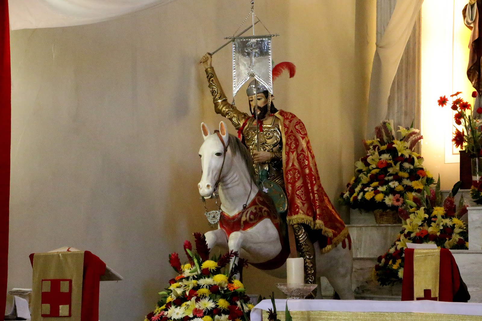
To the left is Santiago Matamoros, St. James the Moor killer, 
mounted on the horse on which he is reputed to have arrived miraculously 
in 9th-century Spain to help defeat the Moors.
To the right, he stands as an apostle and shepherd of his people. 

Santiago Matamoros

Outside, all is quiet.
Papel picado, paper cut in designs, announce the fiesta.


In one corner of the atrio, men are beginning construction of the castillo (castle)
of fireworks which will be set off after dark to culminate the fiesta.
 

The Procession


As the Mass is coming to a close, we hear the sound of cohetes, rocket-style firecrackers approaching from a distance. It is the procession of Santiago through the streets, which, we learn, began at nine AM. It is returning to the church in time for the main Mass to honor Santiago. Soon, it enters through a gate at the side of the church.

The procession enters, led by chinelos, dancers "disguised" in Moorish-style costumes
and masks "burlando", mocking, Spanish gentry.

The central figure wears a traditional chinelo mask imitating a bearded Spanish gentleman.
The pig faces are something we have never seen before on chinelos.
It seems a rather more blatant burla, mockery of the Spanish.

     
We are particularly taken by the elaborate shawl on the chinelo
to the right. It, too, is unusual.

Next comes the patron saint, Santiago.

Santiago is followed by an advocación, manifestation, of the Virgin Mary
that we have not seen before.
We ask a watching parishioner who she is. We are told she is the Virgen de los Remedios,
the Virgin of the Remedies.

We are somewhat taken aback. We have heard and read of la Virgen de los Remedios, but never seen her, as her basilica is outside the City. She is one of the most famous and important advocaciones. i.e., manifestations of the Virgin Mary as an advocate, a protector of the people, in the Valley of Mexico. Studies have shown she was sculpted in Spain. She was reputedly brought from there by Juan Rodríguez de Villafuerte, a captain in Hernán Cortés' army of conquistadors.

On the night of June 30-July 1, 1520, after the Spanish massacre of indigenous priests and nobles during an indigenous fiesta and the subsequent death of Moctezuma, the Spanish were forced to flee Tenochtitlan during the Night of Sorrows. After the surviving Spanish forces had crossed the causeway to Tlalcopan and were fleeing northRodríguez de Villafuerte ostensibly buried the Virgin beneath a maguey plant (a large succulent), hoping she would be safe there and that he might return someday to retrieve her.

She was discovered twenty years later by an indigenous peasant and became a highly revered version of St. Mary. In 1575, her own shrine was built where she was found, in Naucalpan, a city in the State of Mexico bordering on Azcapotzalco. It is now officially designated a basilica, a special church, by the Pope. With the Virgen de Guadalupe, in Tepeac to the north, the Virgen de la Bala (Virgin of the Bullet, in Iztapalapa) to the east and el Niño Pa (The Child [Jesus] of This Place, i.e., Xochimilco) to the south, she is considered one of the guardians of the four cardinal directions (an archetypical, indigenous symbolism) around the City of Mexico. During Colonial times, when there were major floods in the island City of Mexico, she—not the Virgin of Guadalupe—was brought to the Cathedral for the faithful to beseech her aid in stopping the flooding. As many as ten thousand faithful attend her feast day. Thus, it is a great honor for Santiago Ahuitzotla that she has been brought to participate in their fiesta.

A banda, as is traditional, follows at the rear.

The Mass honoring Santiago begins.
La Virgen de los Remedios is at the left,
together with a smaller version called a demandita (little prayer).

La Gente del Pueblo de Santiago Ahuitzotla, the People of the Village of St. James Ahuitzotla


While we were hanging out in the atrio between masses and awaiting the arrival of the procession, as usual, we introduced ourselves to a number of people who were also waiting. 

The man on the left approached us
(we always stand out as the only güero extranjero, pale-faced foreigner, at a fiesta)
and introduced himself as a member of the fiesta organizing committee
(note the figure of Santiago Matamoros on his shirt).
He then introduced us to the committee president (on the right)
and the pueblo's historian (center).
We gave them our card and told them we would be sharing our photos and story 

of their fiesta via Facebook.

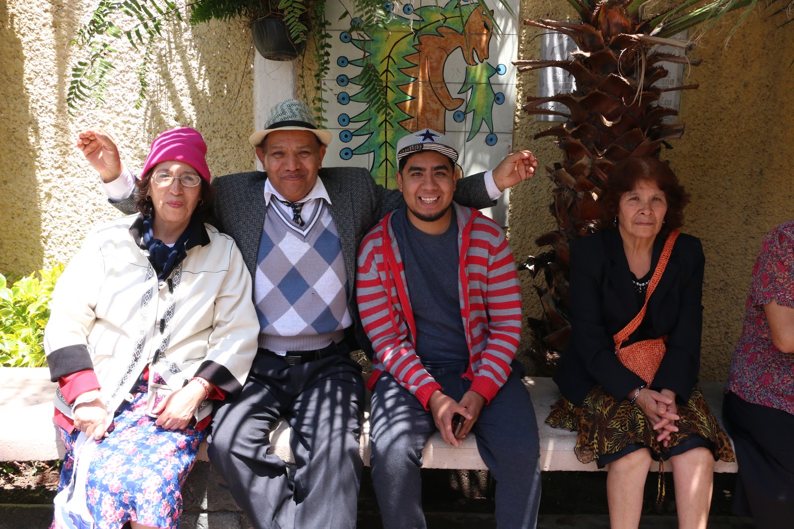
Familia mexicana.

Familia mexicana.

Couple upper right are brother and sister.
Couple lower left are mother and son. 

"What's in a name?" The Meaning of Ahuitzotla (Ahuizotlan)


The indigenous names of pueblos in the Valley of Mexico always have a meaning in Nahuatl, usually related to some identifying characteristic of its location or primary occupation (such as Iztacalco, House of Salt, as salt production was its major industry). So, of course, we wonder what Ahuitzotla means.

In ambling around the atrio, we discover a plaque of tiles embedded in the wall, almost hidden by a hanging plant.  We ask the young man pictured lower left above if he would hold aside the plant so that we may photograph the plaque. He is muy amable (very considerate) and readily assists us.

Plaque with glyph of Ahuitzotla,
or Ahuizotlan as it is spelled here,
indicating it was founded in the year 750 CE,
during the time when Teotihuacan dominated the Valley. 


We wonder what this strange creature is.

Once we are back home we search online for the possible meaning of Ahuitzotla  or Ahuizotlan as it is spelled on the plaque. We know that the prefix -tla or -tlan means place or territory, but what is an ahuexote or ahuizote ('x' and 'z' are both pronounced as 's' or 'sh'), evidently the curious creature displayed on the plaque. 

We quickly find a source in Spanish that tells us that in indigenous times, ahuexote / ahuizote were mythical, monstrous animals. Built like coyotes, they had spines on their backs, rather like a fish, and paws like a monkey´s so they could grasp objects. They also had a claw at the end of their tail. They lived in caves underwater and would lure human victims by making calls like a crying baby. When the victim came close to the water, they would leap out, grab them with their paws and claws and drag them underwater where they would be drowned and eaten. Why a pueblo, originally near the edge of Lake Texcoco, would be identified as the place where such monsters lived is a mystery. It would seem to have been a place to be avoided.

But we are most happy that we have come to Santiago Ahuitzotla in Delegación/Alcaldía Azcapotzalco. The people, as in all the pueblos we have visited, are most welcoming and open in talking with us. They express surprise and a sense of honor that an extranjero has come to their fiesta and will show and tell of it via Facebook and a web blog.

As for us, we have finally succeeded in getting to a place of great historical importance in the indigenous history of the Valley of Mexico, Azcapotzalco, the home base of the Tepanecas, the dominant power prior to the Mexica/AztecaAhuitzotla is just one barrio of the original city. We hope very much to get to others, over time. Meanwhile, we have also succeeded in getting to the fifteenth of the sixteen delegaciones/alcaldias of Mexico City.  

Delegación/Alacaldía Atzcapotzalco
with its pueblos and colonias.

Pueblo Santiago Ahuitzotla
is red area marked by mustard/yellow star.