Giants of Nature Reveal Themselves: Iztaccíhuatl and Popocatépetl
When we were signing our first lease on our apartment in Delegación Coyoacán, in late July 2008, the owner of the condominium surprised us when she told us, "You know, on clear days you can see the volcanoes Iztaccíhuatl and Popocatépetl from the living room."
We had been in the fifth floor apartment, in Colonia Parque San Andrés, two or three times to meet the real estate agent, view it and sign an intention to rent it. Among its features we loved was the huge, floor to ceiling, nine-foot wide window in the main room, with a balcony for plants outside, lots of trees across the street and no tall buildings to block the morning sun.
We had once lived in an apartment in Manhattan that faced north. While it was a great apartment, there was no sun, ever, so light in a city apartment was one of our concerns in moving to Mexico City. However, through the huge window, we had never seen a sign of any volcanoes (summer is the rainy season, marked by large cumulus clouds forming in the East in the afternoon).
We moved into the apartment in early August, but because of clouds, we still saw no volcanoes. Then, one afternoon, about 5:00 pm, we were sitting in our living room, having a glass of wine and watching the towering cumulus clouds building dramatically to the East. They boiled higher and higher, growing darker and darker. Lightening began to discharge from them. A strong wind began to blow from the East. We could see the rain arriving over a small hill a few miles away. Soon, we were enveloped in a torrential tropical downpour.
 |
| Towering cumulus clouds (cumulus congestus) build to the East in the Valley of Mexico on a summer afternoon, during the rainy season. |
After twenty minutes or so, the storm was over and the clouds began to clear. We were stunned by what was revealed before our very eyes!
 |
| Snow-covered Volcán Iztaccíhuatl began to reveal itself. (This and all following pictures are telephoto shots from our apartment in Delegación Coyoacán) |
 |
| Iztaccíhuatl, "The White Woman" in Nahuatl, called La Mujer Dormida, the Sleeping Woman, in Spanish, is actually a massif of volcanoes. Her "head" volcano is to the left. The tallest volcano forms El Pecho, her "breasts". Her "legs", other volcanoes, descend to the right (south). She is familiarly called just "Iztac". El Pecho is 5,230 meters (17,160 ft) in height, making the mountain the third highest in Mexico and the eighth highest in North America. |
 |
| Then, to the south, Popocatépetl began to appear. |
 |
| Popocatépetl, "Smoking Mountain". Reaching 5,426 meters (17,802 ft), it is the second highest mountain in Mexico and the fifth highest in North America. |
 |
| Popo regularly emits a column of steam of various volumes, hence his name, Smoking Mountain. |
 |
| Occasionally, "Popo" (or Don Goyo, as he is also familiarly called by those who live with him) blows his top. In Spring 2012 and again in 2018, he became very active, with eruptions of ash and some rocks and lava. |
 |
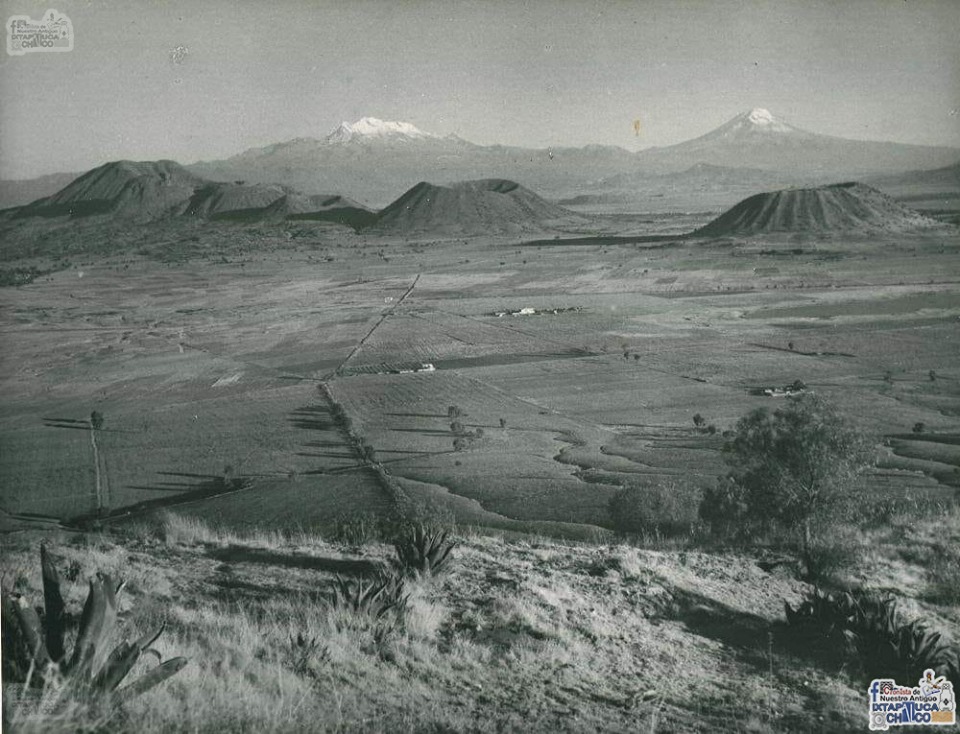
Iztaccíhuatl and Popocatépetl
seen on a clear winter day from our apartment.
El Paso de Cortés, Cortes Pass, through which Hernán Cortés and his troops
entered the Valley of Anahuac in 1519, lies just to left of three-pronged evergreen.
Cortés had some of his soldiers climb Popo at the time.
|
Legend of the Sleeping Princess and Her Warrior Lover
The Sleeping Princess and the Smoking Mountain have their own version of a creation story or legend. There are several versions of the legend, but all center around a kind of archetypal Romeo and Juliet plot in which a princess, daughter of the ruler of the Valley, and a warrior fall in love but are prevented from marrying because the warrior is sent off to war, either with the ruler's intent that he die (think David and Bathsheeba) or because his rivals for the princess' hand report him killed in battle.
The princess, hearing her beloved is dead, dies of grief. The warrior returns and, upon finding his beloved dead, carries her body to the mountains and lays her on a bier. Weeping in the cold air, his tears turn to ice. The gods take pity on such true love and turn both into mountains. Popocatépetl continues to spew smoke and, on occasion, lava and rocks out of his ongoing rage, while his princess sleeps.
Although Iztaccíhuatl and Popocatépetl are forty to fifty miles southeast of Mexico City, they are very important to the identity of chilangos, Mexico City residents. This has been so for centuries.
After being awed by the presence of "Popo" and "Iztac" beyond our living room window, we subsequently learned that if we nos asomamos (leaned our head out) our west-facing bedroom window, we had a view of another impressive, and much closer, volcano.
 | |
|
Sierra del Ajusco - Chichinauhtzin
 |
| Volcán Ajusco leaning out our bedroom window, looking south from Coyoacán, about 12 miles, across Delegación Tlalpan. At 3,930 meters or 12,894 feet in altitude, Ajusco is the highest mountain within Mexico City, rising more than a mile above the Valley of Mexico. |
Ajusco, like Iztaccíhuatl, is another massif of volcanoes. It lies at the juncture of an east-west volcanic chain, the Sierra del Ajusco-Chichinauhtzin (or just Sierra Chichinautzin), and a northward running chain called Sierra de la Cruces (the Crosses) along the West side of Mexico City.
 |
| Relief map: Outline of sixteen delegaciones (boroughs) of Mexico City is overlaid on terrain of the cuenca, basin, of the Valley of Mexico. The Chichinautzin Volcanic Range bounds the South. La Sierra de las Cruces (Crosses) bounds the West. Ajusco is the dark orange peak at the edge of the West side of Mexico City's largest delegacion, Tlalpan (lower left). Volcanoes Popocatépetl and Iztaccíhuatl bound the East side of the Valley (off the map) They are part of the mountain range called la Sierra de Río Frío. The tan area was formerly lakes and lake-shore land. From: la Encyclopedia de los Municípios y Delegaciones de México: Distrito Federal (Mexico City) |
 |
| Sierra de las Cruces Ajusco is at the far left. |
 |
| The Valley of Mexico and Mexico City are surrounded by the Chichinautzin Volcanic Range on the South, la Sierra de Río Frío, with its Volcanos of Popcatepetl and Iztaccihuatl on the East, and la Sierra de las Cruces (Crosses) to the West. Ajusco is left-center. (For full screen view, click on the photo.) |
All the volcanoes around the Valley of Mexico and Mexico City are part of what is called the Eje Volcánico, the Volcanic Axis, or Trans-Mexican Volcanic Belt, a line of volcanic mountains that crosses lower Mexico, from near Puerto Vallarta, in the State of Jalisco on the Pacific Ocean, to Veracruz on the Gulf of Mexico.
It is one of the largest volcanic fields in the world, containing well over three thousand volcanoes of various types: tall conical stratovolcanoes (like Popo, Iztac and Orizaba, which is east of the Valley of Mexico); lava domes (like Iztac's "head"); shield volcanoes (flatter because they exude lava slowly), and innumerable small cinder cones (more about these last in Part II, on the small volcanoes within Mexico City).
 |
| Volcanic Axis (red) cinches Mexico's midsection; It contains over 3,000 volcanoes. Black triangles mark four of the tallest ones: (West to East) Colima (active); Popocatépetl (active), linked by a mountain ridge to Iztaccíhuatl (dormant); La Malinche (dormant 3,100 years); and Pico de Orizaba (active, indigenous name is Citlaltépetl), At 18,406ft., Orizaba is the tallest mountain in Mexico and the third tallest mountain in North America. |
 |
| Portion of Ajusco-Chichinautzin Volcanic Range within Mexico City. Ajusco lies at upper, far-left. In addition to the large, named volcanoes, note the many small cinder cone craters peppering the landscape. |
 |
Tláloc Volcano
at sunset
It actually has two craters, to the left and right.
Height is 3,690 meters or 12,106 ft.It lies near the Southeast corner of Delegación Milpa Alta, in Southeastern Mexico City. |
 |
"Frozen" lava flow from shield volcano Cuautzin.
(looking South)
Cuautzin is between Ajusco and Tláloc.
Delegación Milpa Alta is to the left, Delegacion Xochimilco is lower center, Delegación Tlalpan is to the right. |
 |
| Volcán Cuahtzin A shield volcano, low and flat because its eruptions were slow discharges of lava. |
Living in the Midst of Giants
It is difficult to put into words what one experiences encountering these gaints of nature. We are awed every time Popocatépetl and Iztaccíhuatl appear before our eyes from beyond our living room window. Ajusco, smaller but much closer, also triggers feelings of awe, of wonder. These are the primal human feelings that engendered the belief that these mountains were gods, both protecting and threatening the people of the Valley. When Popo explodes, one feels the world, at least one's immediate one, might be coming to an end.
It is easy to forget the presence of these colossi when going about one's daily life, surrounded at ground level by the built City. But they are always there, even when hidden by clouds (or, yes, pollution), and every so often, one comes into sight of them, particularly when in the southern delegaciones (boroughs) of Tlalpan, Xochimilco, Tláhuac and Milpa Alta. One may also see them when taking a bus out of the city and the Valley, over the mountains, to Cuernavaca to the south, Puebla to the east or Toluca to the west, or flying into or out of the Mexico City International Airport.
How to See, and Even Meet, the Giants.
For visitors to the City (and for chilangos, City residents), it is quite easy to see, if not encounter, the giants surrounding the city. One only has to have the luck of encountering one of the (unfortunately) rather rare crystal clear days that mountain air can provide. Then, carpe diem, seize the day, and go to the Torre Latinoamericana, at the corner of Calle Madero and the Eje Central (Central Axis, aka Ave. Lázaro Cárdenas) in Centro Histórico, pay some pesos and take the elevator to the observation deck at the top of this Empire State Building look-a-like.
From the decks—the lower one enclosed by large windows; the upper one open to the air—on a clear day, the entire Valley of Mexico opens in front of one's eyes. Seemingly not so far away to the south is Ajusco, and to the southeast, la Sierra Chichinautzin. To the southeast, farther away, but still awesome in their majesty, rise Popocatépetl and his beloved Iztaccíhuatl.
For the more adventuresome, it is possible to go to the Parque Nacional Cumbres de Ajusco, the Ajusco Peaks National Park in Delegación Tlalpan. There, one can drive a circular road around the top, hike or bike on trails and even camp overnight.
For the even more adventurous, it is possible to go to the Parque Nacional Iztaccihuatl-Popocatepetl and climb, at least up Iztac and the Paso de Cortés. Popo is often off-limits because of his unpredicatble activity.
One can also encounter volcanoes up close, but now mostly covered by dense and beautiful evergreen forests, in the western, mountainous delegaciones of Álvaro Obregón, Magdalena Contreras and Cuajimalpa. All these delegaciones are, in greater or lesser parts, in la Sierra de la Cruces, which contains eight stratovolcanoes reaching up to 12,700 ft. (3,870 meters).
El Desierto de los Leones, the Wilderness of the Lions, is a national park in las Cruces, with hiking trails, picnic tables and restaurantes campestres, outdoor restaruants. It is only accessible via car.
Aside from a wonderful (and full of wonder) visit to El Desierto and its former Carmelite convent (monastery), we have not yet managed to get to these western delegaciones in our Ambles. We can, nevertheless, see parts of them from our bedroom window.See also: Encountering Mexico City's Many Volcanoes, Part II: Little Volcanoes With Big Histories