Showing posts with label Mexica history. Show all posts

Wednesday, September 18, 2019

Origins of the Azteca-Mexica | From Their Migration to the Valley of Anahuac/Mexico to Their Founding of Tenochtitlan

Prologue 

Mexico City Ambles focuses on the remaining originally indigenous villages that still survive in that part of the Valley of Mexico which is now incompassed by Mexico City. Our goal is to seek out what remains, architecturally and culturally, of their transition from indigenous communitites, with their established cultures and customs, into the Hispanic Roman Catholic parishes and pueblos they are today.
This post provides some of the legendary and historical background to those original communities. Specifically, it recounts the arrival of the Nahuatl-speaking Azteca, also known as Mexica, to the valley called Anahuac, now the Valley of Mexico, around 1220 CE. It was already a highly populated valley, politically organized by various other Nahua tribes into hightly competitive altepetls (city-states). It took the Azteca/Mexica several attempts over one hundred years until they were finally able to settle permanently on some uninhabited swampy islands in Lake Texcoco and found their city of Tenochtitlan in 1325.
One hundred years later, in 1428, with the help of two other altepetls, they were able to take control of the entire valley and establish what has become known as the Aztec Empire. It lasted a little less than one hundred years, until 1521, when the Spanish arrived and defeated it. 

Sources of Azteca-Mexica History before the Spanish Conquest


As we have recounted in other posts, when Franciscan monks arrived in Nueva España a couple of years after Hernán Cortés, his Spanish troops and indigenous allies had defeated the Mexica in 1521, they undertook learning the indigenous languages, so as to commuicate with the people and seek to convert them to Spanish Catholic Christianity, the so-called Spiritual Conquest. In the Valley of Mexico, the predominant language was Nahuatl.

The friars soon learned that the Nahua had a pictographic means of representing their history in books combining drawings and symbolic glyphs. So they requested that various craftsmen in this method work with them to compose books, now known as codices, to record indigenous history and customs. The friars also created an alphabetic means of writing Nahuatl, so fuller explanations of indigenous events and customs could be recorded and translated into Spanish.

A Plethora of Versions


These codices range widely in length, complexity and whether or not they contain Nahuatl script and Spanish translations. Some were compiled within a few years after the Conquest, such as the Codex Boturini (from the name of one of its subsequent owners) or more descriptively, La Tira de la Peregrinación (The Pictorial Illustration of the Pilgrimage). The Codex Aubin, which repeats the Boturini by and large, has alphabetic Nahuatl text accompanying the drawings and glyphs. The Anales de Tlatelolco was written in alphabetic Nahuatl within twenty years after the Conquest.

Las ocho relaciones y el memorial de Colhuacan, The Eight Accounts and the Memory of Culhuacan were compiled in the 17th century by Domingo Francisco de San Antón Muñón Chimalpahin Cuauhtlehuanitzin, or simply ChimalpainHe was a descendant of the royal indigenous family of Chalco (a major altepetl or city-state on the eastern end of Lake Chalco, the most southeastern of the five lakes in the Valley), educated in a Spanish monastery and asked by the monks to record the history of the people of the Valley of Mexico. One of his Relaciones gives his version of the history of the Mexica from their beginnings in a distant and mythical past.

The most extensive and elaborate of the codices is actually a huge series of volumes intentionally compiled between 1558 and 1575 by the Franciscan Bernardino de Sahagún, entitled Historia general de las cosas de la Nueva España (General History of the Things of New Spain), written both in Nahuatl and Spanish. It consists of twelve books, totaling 2,400 pages.

The events recorded in the codices begin in legendary times and their recollection was transmitted orally for centuries, so there are many variations regarding the events recorded in the narratives, making it difficult, if not virtually impossible, to reconcile them into a "definitive history." Many scholars have tried. One of the most recent attempts is that by history professor Federico Navarrete Linares, entitled Los Orígines de Los Pueblos Indígenas del Valle de México (The Origins of the Indigenous Peoples of the Valley of Mexico, 2010, National Autonomous University of Mexico, available online in PDF)

Recording History: How the Azteca-Mexica Kept Track of Years


An additional challenge for non-indigenous writers and later readers of these histories has been correlating the events related in them to the European-based Gregorian calendar (which was not created in Europe until near the end of the 16th century as a revision of the Julian calendar used since the Roman Empire).

Archaeologists working to uncover and understand the Maya civilization, much farther south from Tenochtitlan/Mexico City, have learned that the Maya had developed what is called the Long Count calendar, using a system of bars and dots, which has an absolute starting date equivalent to August 11, 3114 BCE. All subsequent years were numbered using this system, and stela portraying specific events, such as a lord's coronation, bear the specific year in which it occurred. Hence, these year dates have been correlated with Gregorian calendar dates.

However, the Nahua had only a circular means of identifying years. Called the nexiuhilpiliztli, (meaning the completion of a perfect cycle of years), it consisted of the rotation of four names in combination with thirteen numbers, producing fifty-two possible combinations. The four names, each related to one of the four cardinal directions, were:
  • Ácatl (Spanish: Cañas = Canes or Reeds), related to the East, where the sun rises;
  • Técpatl (Spanish: Pedernales = Flints), related to the North
  • Calli (Spanish: Casas = Houses, i.e. Clans), related to the West
  • Tōchtli (Spanish: Conejos = Rabbits), related to the South
The combination of this sequence of four names with the numerical sequence of numbers one to thirteen resulted in a fifty-two-year-long cycle. The first year in the cycle was 1 Ácatl (Reed), followed by Técpatl (Flint), then 3 Calli (House) and 4 Tōchtli (Rabbit). The next four-year sequence in the cycle began with 5 Ácatl (Reed), then 6 Técpatl, and so on. The cycle of combinations continued until all 52 possible combinations of names and numbers had occurred.


Depiction of the fifty-two-year cycle of the nexiuhilpiliztli.

The circular sequence of year name-number combinations depicted here
begins next to the center (sun), 
in the bottom ("oriente", i.e. east axis, where the sun rises)
and moves counter clockwise. 

1 Acatl (Caña, Reed),
Técpatl (Pedernal, Flint), (in the norte, north axis);
Calli (Casa, House or Clan) (in the "occidente", i.e. west axis);
Tōchtli (Conejo, Rabbit) (in the sur, i.e. south axis).

The next four-year sequence begins with 5 Acatl (Caña, Reed)

and ends with 8 Tōchtli (Conejo, Rabbit)
The entire 52-year cycle ends on 13 Tōchtli (Conejo, Rabbit)

From: Museo del Nuevo Fuego, Cerro de la Estrella, 

Museum of the New Fire,  Hill of the Star,
Delegacíon/Alcaldía Iztapalapa.

This fifty-two year-long sequence of years was central in the Nahua and virtually all Mesoamerican cultures because they had two distinct calendars: a 365-day solar calendar and a 260-day divinatory calendar, used to determine the good or bad outcome of events, including the fortunes of the lives of people born on any particular day of the cycle.

The first day of both calendars coincided only once every fifty-two years, and that conjunction was believed to carry the danger that the sun might not rise and the world would come to an end. Hence, this day was of great cosmic and religious importance.

The day on which the two calendars coincided was called xiuhmolpilli (sheeoo-mol-PEEL-yee) the Tying of the Years. The Spanish named it the el Nuevo Fuego, The New Fire, as all fires were extinguished and a new one was started by priests on the top of a small ancient volcanic cone they called Huizachtecatl, what is now called Cerro de la Estrella, Hill of the Star (near the center of the Valley and once at the western end of the peninsula separating Lakes Texcoco and Xochimilco, now in the Delegación/Alcaldía Iztapalapa).

From there torches were carried to all temples in each pueblo and from there, to every home, to relight new fires. For some reason we haven't yet discovered, the Tying of the Years always occurred on the first day of the year 2 Actl, (2 Reed). (For more on the ceremony of the Tying of the Years and the two calendars for counting the days of the solar year and for naming and counting days in the 260-day-long divinatory calendar, see our post, Hill of the Star and the Origins of Culhuacán and Iztapalapa.)

As the events recorded in the Mexica codices begin in legendary times and their recollection was initially transmitted orally, there are many variations regarding the events recorded in the narratives, as well as in the dates related to them. Thus, while modern scholars have been able to correlate with the Gregorian calendar the Nahua dates in specific codices, the correlations between different codex dates vary because of differences in narratives and in determining in which fifty-two-year cycle they occurred.

Challenges to Sorting Out a Single History


Many historians have tried to sort out these confusing records. Some think their discrepancies reflect that the Mexica may have divided up into various groups, arrived at the Valley of Anahuac at differing times and gone into different parts of the Valley, such that events reported as if they occurred with a single group and in a temporal sequence are actually the interwoven experiences of dispersed Mexica at various times. In addition, some of the chronicles, such as those of Chimalpin, were written by members of other tribes already established in the Valley; therefore, they reflect their recollections and version of their interactions with this new tribe "in town".

The Mexica histories themselves were most likely altered over time to give emphasis to their ultimate successes while diminishing or even overlooking their defeats. Historians do know that in the 15th century, some one hundred years after the Mexica had founded their own altepetl of Tenochtitlan, a member of the ruling royal family, named Tlacaelel, deliberately had the story of the Mexicas rewritten. Tlacaelel was a nephew of the huey tlatoani (senior speaker, i.e. chief) Itzcoatl, and a younger brother of the later huey tlatoaniMoctezuma I.

When, in 1428, the Mexica or Tenoch of Tenochtitlan, led by Itzcoatl, rebelled against their overlords, the Tepaneca of Azcapotzalco, on the western shore of Lake Texcoco, Tlacaelel was given the office of tlacochcalcatl (top general of the army) in the war. After leading the Mexica warriors to victory, he was then named to a new position called cihuacoatl, first adviser to the ruler. He held that office during the reigns of four consecutive tlatoani, until his death in 1487. He was, one might say, the mind behind the throne.

Tlacaelel took charge of a rewriting of the Mexica story, casting them as the chosen people of Huitzilopochtli. It is likely that, up until the rise of the Mexica to dominance in the Valley in the 1430s, Huitzilopochtli had only been their tribal god. Now he was elevated to the top of the pantheon of all the gods of all the altepetls incorporated into what has come to be called the Aztec Empire. Huitzilopochtli became the representation of (and justification for) the now-dominant Mexica's military success and its achieved identity as masters of what is now central Mexico. His choosing the Azteca of Aztlán as His people, renaming them Mexica and leading them on a long pilgrimage to their true destination and destiny was sacred history.

Nevertheless, in spite of all the challenges presented by these codices, it is thanks to them that we know as much as we do about Nahua culture and history prior to the Conquest, especially that of the Mexica.

Legendary Origins of the Azteca/Mexica


The simplest depiction of the Azteca/Mexica origins and their migration to the valley of Anahuac is presented in the Codex Boturini, The Pictorial Illustration of the Pilgrimage). It was created shortly after the Spanish Conquest. In simple imagery, it portrays key events along the way, accompanied by glyphs, symbols that identify place names, and the number-name combinations the Nahua used to designate the year or years during which the Mexica spent time in a place.

The Codex Aubin, bearing a Gregorian date in the 1550s, repeats and expands the pictographic history of the Codex Boturini, but also adds a narrative written in Nahuatl script. To the great fortune of English speakers, a project at Fordham University (New York City) has translated much of the Nahuatl into English, making its narrative available to such persons as us.

According to these two early codices, in the latter half of the 12th century CE, the Azteca migrated from a homeland they called Aztlán (the origin of the name Aztec(a), an island in a lake, or surrounded on three sides by a river, some unknown distance to the northwest of the present Mexico City.

Other codici give much earlier dates for the exodus, a hundred years earlier. The Anales de Tlatelolco give the day and year of the exit from Aztlán as "4 Cuauhtli" (month of Four Eagle) of the year "1 Tecpatl" (Flint), which correlates to January 4, 1065. Chimalpain, in his Eight Accounts and the Memory of Culhuacán, also dates the Azteca migration a hundred years earlier, in 1064 CE. Such is the nature of legends that merge into what we know as recorded history.

When the exodus occurred — and whether or not Aztlán was an actual, specific location — is debated by scholars. Most probably, it relates to some area that is now in the southwestern U.S. or northwestern Mexico. This is evident because Nahuatl is a member of what is known as the Uto-Aztecan language family, a number of members of which existed — and still exist — in that area. They include Ute, Comanche, Shoshoni and Hopi, as well as the languages of some native tribes in what is now California.

The initial scene in the Codex Boturini
shows the Azteca leaving the island Aztlán.
Around the temple on the island are six capulli, houses,
i.e. clans composing the tribe.
The year glyph in the center is 1 Flint, 1164 CE.

Crossing the lake, the Azteca arrive at a place called Colhuacán, "the place of the ancient ones" (a significant name, as we shall see later). There they encounter eight other Nahua tribes who ask to accompany them on their migration. They include the Chalca, Xochimilca, Cuitlahuaca and Tepaneca, all of whom actually arrived in the Valley of Anahuac (now the Valley of Mexico) before the Azteca.

In Colhuacán they also encounter the god Huitzilopochtli, Humming Bird of the South (portrayed in the drawing as a head hanging inside a cave). He tells them he has adopted them as his people and will lead them to a new home.

Shortly afterward, the Azteca and the other eight tribes arrive at a place called Tlatzallan Texcaltepetzallan. There, at the order of Huitzilopochtli, the Azteca announce to the other tribes that they are leaving them behind and going ahead on their own. This is represented by a drawing of a tree that suddenly, miraculously splits. Subsequently, they reach a place called Cuextecatl, where Huitzilopochtli announces to them, "Your name is longer 'Azteca'. You are now the 'Mexica.'

Reaching Tollan, the Threshold Between Legend and History


According to the Boturini and Aubin codices, the Mexica then spent nearly thirty years wandering southeastwards, arriving at the city of Tollan in 1196 (Aubin Codex) or 1201 (Boturni Codex), where for the first time, they settle for a number of years (19 according to the Boturini, 20 according to the Aubin). Tollan had been the center of the Tolteca Empire, dominating the area that is now south-central Mexico after the decline of Teotihuacan (around 600 CE), from 900 to about 1150 CE. So, by the time the Mexica arrived about fifty years later, it was virtually abandoned. Its dramatic ruins are now a major archeological site, known as Tula, in the southwestern corner of the State of Hidalgo, about 45 miles northwest of Mexico City.

The Mexica arrive in Tollan
(represented by the glyph of reeds sprouting from water, holding a fish)
in year 4 Calli (House or Clan) 1201 CE,
and stay until 9 Acatl (Cane or Reed), 1219 CE.
The sequence of nineteen years of name-number glyphs begins at lower left.
It is read from bottom (4 House) (1201 CE) to the top (8 House),
then down the second column from 9 Rabbit to 13 Rabbit,
then up the third column from 1 Reed to 5 Reed,
then from the top of the fourth column, 6 Flint, to 9 Reed (1219 CE).
Boturni Codex 

Despite Tollan's state of ruin, the Mexica surmised or learned from people in the area of its importance and saw it as a model of the altepetl they hoped someday to found. Subsequently, when they did arrive in the Valley of Anahuac, they were to seek alliances with the residents of Culhuacán (also spelled Colhuacán), Tolteca who had settled in the Valley at the same time Tollan was beginning to rise to power in the 7th century. Establishing alliances with the Culhuas, the Tolteca of Culhuacán, via marriage and military support was a major way to establish a hereditary connection with that great culture and, hence, political legitimacy and status among the other peoples of the Valley.

Tollan was an abandoned place of the past when the Mexica arrived, but it was certainly an historical location and culture that had already had much influence on the history of the neighboring Valley of Anahuac, and, via its Culhua relatives, it would come to play a major role in the development of the history of the Mexica once they crossed the threshold from the Tula Valley into the Valley of Anahuac.

Entering the Valley of Anahuac and Joining the Tangled Threads of History


The Mexica left Tollan and spent a few years moving southward. According to the Boturini and Aubin codices, sometime between 1220 and 1240, they entered the north end of the Valley of Anahuac. It is important to realize that this entrance was not just a physical transition. It was also the beginning of a transition from a lifestyle of hunter-gatherer nomads into a world that was primarily agricultural, based on corn, and politically organized into hierarchically structured altepetls, city-states, with certain cities controlling various amounts of territory and their subsidiary villages around them. It was civilized.

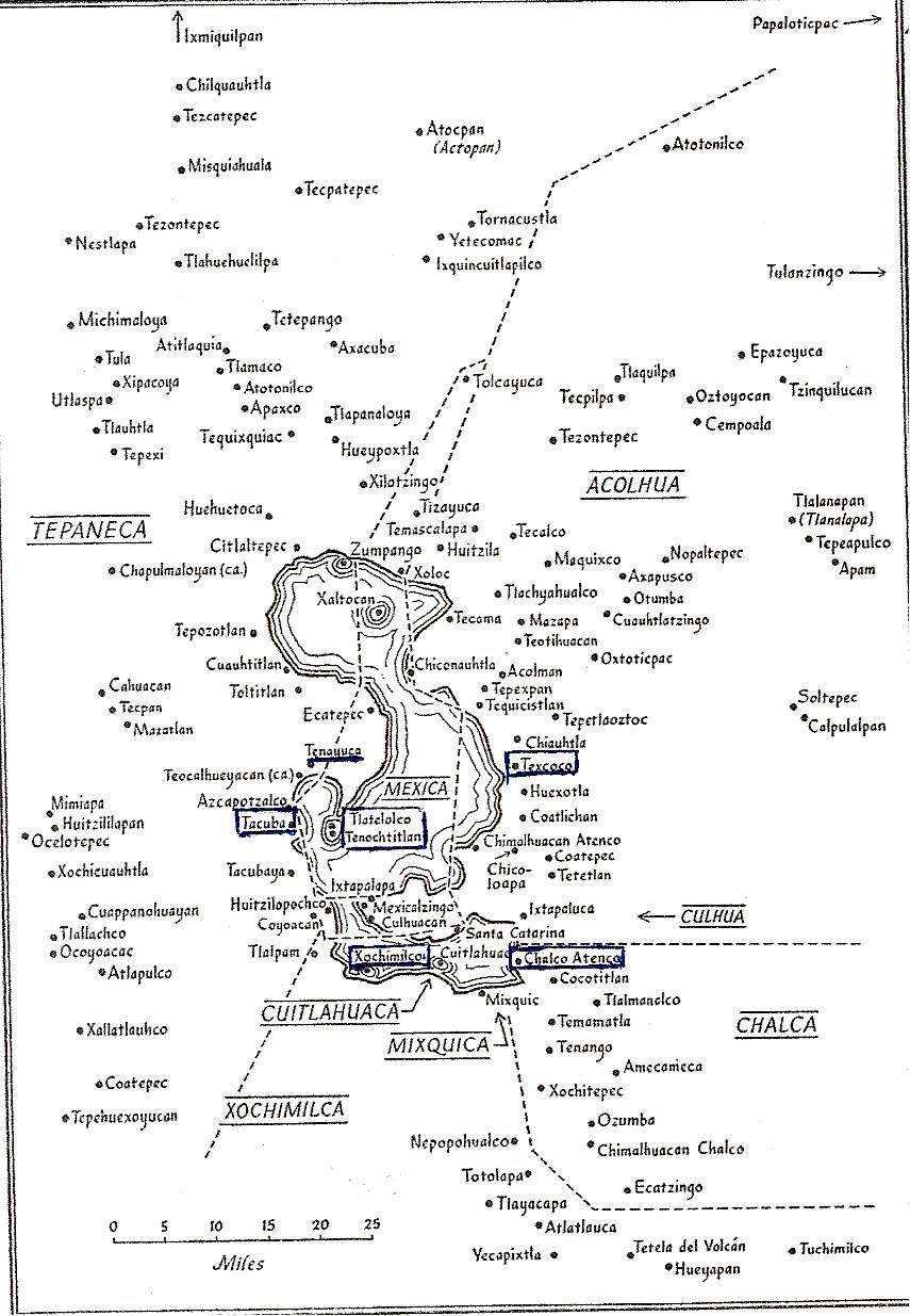
Map of the Valley of Anahuac
at the time of the Azteca/Mexica arrival in the 13th century.
It shows major altepetls and other settlements in the Valley.
Many are mentioned in the account that follows.

The large island shown in the bay in the southwest of Lake Texcoco,
where the Mexica were to establish Tenochtitlan, was not one large island.
It was a group of islands they cobbled together using pilings and earth-fill,
and crisscrossed by multiple canals, remains of the lake that had divided the islands.

The Azteca apparently very quickly caught onto the political system and sought the earliest opportunity to establish a place for themselves within it rather than remain on the periphery as chichimecas ("barbarians") from the point of view of Valley residents and, thus, vulnerable to the powers that controlled the Valley. Their leader, Tozcuecuextli, soon established an alliance with the tlatoani, speaker, i.e. chief, of the altepetl of Tzampancgo (of Zampango as it is now known) via marriage to a princess named Tlaquilxochitzina. Tzampancgo was at the head of the northernmost of the five lakes in the Valley. Tzampancgo was actually subsidiary to the altepetl of Xaltocan, on the next lake to the south, which bore that name. 

First Attempts to Establish a Recognized Settlement


In 1240, Tozcuecuextli, now having an alliance with Tzampancgo and, implicitly, with its overseer, Xaltocan, took the next step toward establishing the Mexica as settled residents of the Valley. He founded a village and named it Huixachtitlan. It was the first of several attempts by the Mexica to found their own independent altepetl in the Valley, almost a century before Tenochtitlan would be founded. 

The chronicles then add that the Mexica no longer lived primarily by hunting and gathering, but became stone cutters in the mountains around the Valley and construction workers in many of the other villages and altepetls in the valley. They also hired out as mercenary warriors for the frequent battles that took place between altepetls trying to expand their dominions. This established a military skill which was to come to be of central importance in their later development.

This second vocation, as mercenary warriors, proved immediately beneficial when, in 1245, a war broke out between an altepetl named Tenayocan (on the north shore of a bay on the southwest side of Lake Texcoco, the largest of the five) and the altepetl of Colhuacan (or Culhuacán, on the western end of the peninsula separating Lake Texcoco from Lake Xochimilco to its south). In or around 1250, the Mexica formed an alliance with Culhuacán, again, via marriage. This time a daughter of Tozcuecuextli, and Tlaquilxochitzina, named Azcaxotzin was married to a prince of Culhuacán named Acxocuauhtli. The chronicle goes on to say that a son named Coxcox (or Coxcoxtli) was born of this union and he would later become the tlatoani of Culhuacán. We will meet him later in that role, which proved to be a climatic one for the Mexica.

In 1272, Tozcuecuextli died and was succeeded by his son, Huitzilihuitl, who, in 1274, decided to found another village called Cuauhmixtitlan, on an island in Lake Texcoco. At this point, the Mexica allied themselves with the altepetl of Azcapotzalco on the nearby west shore of the Lake. Azcapotzalco was the primary altepetl of the Tepaneca people who controlled many other villages on the west side of the lake. Some scholars think Cuauhmixtitlan was founded on the same island that would become Tenochtitlan some fifty years later. In any case, it seems to have soon been abandoned or become a minor settlement, because the Mexica found a better place to live than a swampy island — and it was one the lords of Azcapotzalco did not control.

In 1281, the Mexica captured Chapultepec from a group of Tolteca, relatives of the Culhua of Culhuacán, far across the Lake. (So much for blood alliances!) Chapultepec was an area of shoreline centered around a small, extinct ash volcano with freshwater springs, on the west side of Lake Texcoco. Here, using the hilltop as a fortress, the Mexica settled. Huitzilihuitl was named tlatoani, "speaker" the official title of a ruler of a recognized altepetl. With this act, the Mexica were declaring their independence as a city-state, subject to none other in the Valley.

The Plot Thickens


The independence of the Mexica as an altepetl at Chapultepec lasted only about twenty years, until 1299, when a group of other altepetls, Xaltocan, Colhuacan and Chalco (at the east end of the most southern of the lakes), apparently not liking the growing size and power of the Mexica at Chapultepec, attacked in one or two waves. The Mexica were overwhelmed. Huitzilihuitl and two daughters (he had no sons) were taken captive, first north to Xaltocan and then south to Culhuacán. There, they were sacrificed.

The remaining Mexica fled into the marshes around the lake but then, with no other option before them, went to Culhuacan to surrender and offer themselves as slaves in order to survive. The tlatoani of Culhuacán was none other than Coxcox, son of a Mexica mother and a nephew of Huitzilihuitl! Coxcox gave them an area of land called Tizaapan on the north shore of the peninsula to settle themselves.

Huitzilihuitl and his daughter Chimalaxoch
are brought before Coxcoxtli of Culhuacan, to be sacrificed.
Codex Boturini
The year glyphs to the right, 
from top to bottom, read from 3 Técpatl (Flint) to 6 Ácatl (Reed).
equating with the years 1300 to 1303.

The Mexica and the Culhuas of Culhuacán


In 1303, the Colhuas went to war with the Xochimilca (a powerful altepetl that controlled the Valley on the south side of Lake Xochimilco).
MCA Note: What follows is excerpted from translations of Nahuatl of the Codex Aubin; the translation is a combination of one done by Fordham University in New York City and by us from a Spanish translation done by Patrick Johansson K. “La fundación de México-Tenochtitlan: El mito y la historia”, The Foundation of Mexico-Tenochtitlan: The Myth and the History,
The Colhuas began to lose, so Coxcoxtli said, "Have the Mexica left? Bring them here." So they called the Mexica and they came before the ruler of the Colhuas, who said to them, "Go to the Xochimilca, who are defeating us so far. You are to capture eight thousand Xochimilca, who will be your prisoners (hence, slaves)."
Then the Mexica said, "We will, O ruler. Please grant us at least a meager shield and a meager club."
The king answered, "I won't. You agree to go as you are."
The Mexica then began to consult with each other. "What will we take with us?" they said. We will cut off the noses of our enemies. Because if we cut their ears, people could say, "Maybe you cut them off from both sides. Let's not have that. Instead, let's cut off their noses and fill up sacks with them to count how many there will be."

Then the Mexica arrived at the edge of the settlement of the Xochimilca. The Mexica came back and their captives were counted before the ruler Coxcoxtli. The Mexica said, "O ruler, here are all our captives. We caught 32 thousand of them."
Then Coxcoxtli called for his advisors. He said to them, "The Mexica are not human. How did they do this to the Xochimilca? ... The deaths they're responsible for are a bad omen." 
Only four of the Mexicas' captives remained alive, but they didn't let the ruler Coxcoxtli see that. (To celebrate) They set up an earthen altar there in Tizaapan, "Now O Ruler, give our earth altar a little something to adorn it."
Then the ruler said, "I will. You have done me a favor. I will have the priests go adorn it."
Here other accounts of this event differ widely as to what Cocox offered for the ritual. They say the Mexica asked for one of his daughters, whom he provided, thinking she would be an honored guest. Instead, the Mexica dressed her as one of their goddesses and sacrificed her, which was part of their customs. When Coxcox arrived and discovered this, he was, of course, enraged and drove the Mexica from Tizaapan. 

The Codex Aubin gives a much less violent and more symbolic offense for the split between the Culhuas and the Mexica and places the blame on the Culhuas. It says that as gifts for the Mexica altar, in the night the priests brought piles of animal dung. The next morning, when the Mexica discovered this insult, conflict broke out between the two tribes and the Mexica were forced to flee.
,

The Mexica Seek an Island of Their Own


Fleeing the Culhua, in 1303, the Mexica tried to settle first in Mexicaltzingo, not far north of Culhuacán, at the western end of the peninsula, possibly an island just offshore. The residents there forced them to move on. As most of the shores around all the lakes were already occupied and controlled by various Nahua tribes, the only remaining alternatives were a series of small islands in Lake Texcoco, to the north of the peninsula.

The Mexicas moved to a nearby island (later called Nextipac), and, according to the codices, remained there for four years. But the Culhuas attacked and burned the entire settlement, leaving no trace of it. The Mexica then moved on to Iztacalco, farther north in the lake, but were again forced by existing residents to keep moving.

Finally, in the year 1325 CE, they came to an island or set of uninhabited islands near the western shore that were under the control of the tlatoani, lord of Azcapotzalco. He granted them the right to establish their village there, which they named Tenochtitlan. In exchange, they became subjects of the lords of Azcapotzalco and mercenary warriors in its battles against other altepetls in the Valley. These included Culhuacan and Texcoco, the altepetl of the Alcolhuas who occupied the northeast side of Lake Texcoco. Defeating Culhuacan and Texcoco brought all of the area around Lake Texcoco under Tepaneca control.

In 1428, when there was an intrafamilial struggle for who would be the next tlatoani of Azcapotzalco, the Mexicas joined with the Alcolhuas of Texcoco and Tlalcopan, a Tepaneca village south of Azcapotzalco, forming the Triple Alliance against their rulers. They defeated them and quickly took control of the entire Valley. As the most powerful member of the Triple Alliance, the Mexica of Tenochtitlan became the dominant force, receiving the most tribute from subjugated altepetls in the Valley of Anahuac and then beyond. As such, they were the leaders of what historians have called the Aztec Empire.

The Valley of Anahuac
at the time of its domination by the Mexica of Tenochtitlan.

The End of an Empire


The "empire" would last less than one hundred years. In November 1519, Hernán Cortés, his Spanish troops and indigenous allies who opposed Azteca domination, crossed the mountain pass now named after Cortés and entered the Valley of Anahuac. Two years later, in August 1521, the Azteca Empire was overwhelmed by that of the Spanish. Tenochtitlan was replaced by la Ciudad de México, the City of Mexico and the Valley became the Valley of Mexico. The Aztec Empire, as well as lands far to its north and south, became Nueva España, New Spain. 

Friday, July 26, 2019

Tenayuca and Acatitlán, State of Mexico | Remnants of Indigenous Civilization in the Valley of Mexico

Ambling Beyond Our Normal Bounds


In this amble, we go beyond two of our usual boundaries — the one that focuses us on the still-vital, originally indigenous pueblos and barrios of Mexico City and the boundary of the City, itself. We go a short distance north and west of the City's most northern delegaciones/alcaldías, Azcapotzalco and Gustavo A. Madero, into el Estado de México, the State of Mexico, which surrounds the City like a lopsided horseshoe on the west, north and east. Our destination is two Mesoamerican archeological sites, Tenayuca and Acatitlán.

Our opportunity to visit the sites was provided by Arqueología viva México, led by archeologist Gerardo Orozco, who, via its Facebook page, organizes excursions to sites in and around Mexico City, as well as elsewhere in Mexico. We have wanted to see Tenayuca and Acatitlán since our early days in Mexico City, but were not able to negotiate the complexities of public transportation, via Metro and Metrobus, to get to the sites on our own. Sr. Orozco led the way, as well as sharing his professional knowledge of the sites.

Via Metrobus, we cross into the State of Mexico, an invisible line obliterated by the continuous, modern urban sprawl that has spread from the city and filled the Valley of Mexico since the late 20th century to form the Greater Mexico City Metropolitan Area. Crossing the line, we recall that before the huge expansion of the boundaries of the former Federal District in the mid-19th century, much of what is now part of the City belonged to the State of Mexico.

After Mexican Independence was won in 1821, the new government initially defined the state's boundaries to be the same as they were as a province under the Spanish. The state and preceding Spanish Province of Mexico encompassed a much larger territory than the present state. It included what are now the states of Hidalgo, to its north, and Morelos and Guerrero to its south, which were created in 1869 by President Benito Juárez. (See our page: How Mexico City Grew From an Island Into a Metropolis.)

File:Mexico (state) in Mexico (zoom).svg
The State of Mexico
is the red area.
Mexico City is the small, white triangular shape within its embrace. 

The state of Hidalgo (large) is to the north.
The states of Morelos (small) and Guerrero (large) are to the south.
Wikipedia

Boundaries in the Valley Before the Spanish Arrived


Thus, the boundary between Mexico City and the State of Mexico is highly arbitrary. The natural boundary is made up of the mountains that surround and form the Valley of Mexico (See our post: Mexico City's Many Volcanoes, Part I: Giants on All Sides). When Hernán Cortés, his troops and indigenous allies he had made while traveling west from Veracruz on the coast of the Gulf of Mexico arrived in the Valley in November 1519 (five hundred years ago this year), he found it filled with hundreds of indigenous cities, villages and hamlets, all interconnected parts of one socio-cultural, civilized, Nahuatl-speaking world.

They were not however, what historians traditionally called the "Aztec Empire". The Valley was politically and economically divided into eight tribal altepetls, city-states. Among these eight entities, the Mexica/Azteca altepetl, based in the city of Tenochtitlan, on an island in a southwest bay in Lake Texcoco, was only one among many. Moreover, it had been the dominant altepetl for just under a hundred years, since 1428. Before that, various others of the altepetls had striven for and been dominant for various periods of time since the Nahua tribes had entered the Valley between the 7th and 13th centuries.

Tribal boundaries in the Valley of Mexico
at the time of the arrival of the Spanish in 1519.
From Gibson, Charles, The Aztecs Under Spanish Rule,
Stanford University Press, 1964.

The Triple Alliance


Three of the altepetls were the most powerful, having formed the Triple Alliance in 1428. It was this Triple Alliance that constituted what has been called the "Aztec Empire". In 1519, it dominated the other altepetls in Valley and other tribal city-states far beyond the Valley in what is now central Mexico. All the others paid tribute to one or another of the three. The Mexica of Tenochtitlan were the most powerful of the three and received the most tribute, but the other two were autonomous in regards to their internal government. They were the:
  • Acolhua, with their capital at Texcoco, on the east side of the lake. The second most powerful member of the Alliance, they did not pay tribute to the Mexica. Its territory is now in the State of Mexico.
  • Tepaneca, with their capital at Tlalcopan (called Tacuba by the Spanish), on the west side of the lake. Tacuba is now the cabecera, government headquarters, of  Delegación/Alcaldía Miguel Hidalgo in the City of Mexico.
The Triple Alliance was formally created after the Mexica, the Acolhua and the leaders of the Tepaneca town of Tlalcopan defeated the Tepaneca rulers in 1428. The Tepaneca had been the dominant force on the west side of Lake Texcoco for more than a hundred years. Their capital had been Azcapotzalco, which was destroyed in the war, so the capital was then moved a short distance south to Tlalcopan. They thereafter remained subordinate to the Mexica, but the rulers of their towns were allowed to continue to control internal matters and collect tribute — part was used to support themselves and part was shared with Tlalcopan.

The Other Altepetls


Two other large tribal groups were the 
  • Xochimilca, in the south, with their capital at the island city of Xochimilco, on the lake of that same name. They were among the earliest Nahua tribes to settle in the Valley, around 900 CE. They had been defeated, in turn, by the Culhua (see below) at the end of the 13th century, by the Tepaneca in the 14th century and, finally, by the Mexica in the early 15th century and their territory reduced. Their capital is now the cabecera of Delegación/Alcaldía Xochimilco.
  • Chalco, to the southeast, with their capital at Chalco-Atenco on the east end of Lake Chalco.  They were subjugated by the Mexica but rebelled from time to time. It is now a municipality in the State of Mexico.
Three smaller but still distinct tribes completed the population of the Valley. They were the
  • Culhua, with their capital, Culhuacán, at the west end of the Iztpalapa Peninsula, between Lakes Xochimilco and Texcoco. They had been a dominant force, controlling more territory, until they were defeated first by the Tepanecas in the 14th century, then by the Mexica in the 15th century. Culhuacán was then left controlling only three other towns, Iztapalapa and Mexicaltzingo on the tip of the peninsula, and Huitzilopochco (now the barrios of Churubusco), across the channel connecting the two lakes, in what is now Delegación/Alcaldía Coyoacán. Culhuacán is now divided into Pueblo Culhuacán in Delegacion/Alcaldía Iztapalapa and the adjoining Pueblo San Francisco Culhuacán in Coyoacán.
  • Cuitlahuaca, whose capital occupied an island dividing Lake Chalco from Lake Xochimilco. They never controlled much territory beyond a few nearby towns on the north and south lakeshore. It is now the cabecera of Delegación/Alcaldía Tláhuac (a shortened form of Cuitlahuac) which includes the pueblos it formerly controlled. 
  • Mixquica, whose capital, Mixquic, on the south shore of Lake Chalco was all they controlled. It is now Pueblo San Andrés Mixquic incorporated into Delegación/Alcaldía Tláhuac.
In 1521, Cortés' Spanish soldiers, together with indigenous allies both from within and outside the Valley, defeated the Mexica of Tenochtitlan and then went on to take control of all of the Valley, either by might or the voluntary submission of the other tribes. From Gibson, Charles, The Aztecs Under Spanish RuleStanford University Press, 1964.

Tenayuca


Tenayuca means "walled place" in Nahuatl. The archeological remains of Tenayuca are located in the originally indigenous Pueblo San Bartolo Tenayuca in the municipality of Tlalnepantla de Baz, in the State of Mexico. At the time the Spanish arrived, it was under the control of the Tepaneca (see above map of tribal territories), which it had been for some time before the Mexica became "the first among equals" in the Triple Alliance.

Tenayuca
lay at the northern-most end of the southwest bay
of Lake Texcoco.
During the time of Mexica/Azteca rule,
it was at the end of a long causeway
from Tenochtitlan/Tlatelolco.

Archaeological remains recovered from Tenayuca indicate that the site was first occupied in the Classic Period (100 to 600 CE), when Teotihuacan, in the northeastern part of the Valley, dominated the area. Its population increased in the early Postclassic (600-1100 CE) during the reign of the Tolteca based in Tula, outside the valley to the northwest.

It continued to increase after the fall of Tula (1150 CE), when, with the lack of a central dominating power, many nomadic tribes, generically called "chichimeca" [a pejorative term used by settled, agrarian peoples with urban centers, hence, "civilized", to denote nomadic hunter-gatherer tribes from the north] moved through the area formerly controlled by Tula and entered the Valley that was called Anahuac.

According to the Codex Xolotl, Tenayuca, itself, was founded in 1224 CE by Xolotl, ruler of a Nahuatl-speaking chichimeca tribe whose actual name is unknown. Xolotl was succeeded by Nopaltzin who married Atototztl, a Tolteca princess, in order to establish a linkage with the royal lineage of Tula, seen by all the new tribes as the epitome of a civilized society. When Nopaltzin died, his son, Quinatzin, transferred the seat of power to the east side of the lake that came to be known as Lake Texcoco and founded the altepetl (city-state) of Coatlichán. Quinatzin left a maternal uncle, Tenacacaltzin, to be lord of Tenayuca.

On or about 1337, another tribe, the Acolhua, defeated the chichimeca of Coatlichán and made Texcoco their capital city (see map of tribal boundaries above). Tenayuca allied itself with the Acolhuaswho dominated the northeast region of the Valley of Mexico in the mid-14th century.

However, in the late 14th century, Tenayuca was conquered by the Tepaneca of nearby Azcapotzalco. About a hundred years later, in the 1430s, after the Mexica of Tenochtitlan and their allies, the Acolhuas and Tlalcopan, conquered Azcapotzalco, bringing the Tepaneca under the control of the Triple Alliance, Tenayuca came under the control of Tlalcopan. It remained so until the Spanish came and conquered the entire Valley in 1521 (modified from Wikipedia).

The Temple of Tenayuca


Temple architecture that was built during the period of Mexica/Azteca dominance is based on that which originated at Tenayuca. It consists of a pyramidal base supporting two temples. The Mexica/Azteca adopted this innovative style for their own main temple, now known as the Templo Mayor, in the center of what was Tenochtitlan.

Pyramid of Tenayuca
with its stairway leading to what were two temples.

The archeological site consists of a massive pyramidal platform with a stairway rising on the western side to where the twin temples of Tlaloc (god of all waters, essential for agriculture, the basis of urban civilization) and Huitzilopochtli (son of the sun god, Tonatiuh and god of war, the Mexica's primary god) once stood. The temple of Tlaloc occupied the northern part of the pyramid while the Huitzilopochtli temple stood to the south. To the south of the stairway at ground level is a projecting platform bearing sculptures of crossed bones and projecting skulls. It is likely where human sacrifices were carried out or completed after being initiated in one or the other of the temples above.

Southwest platform of skulls and crossed bones.

Like many Mesoamerican temples, various phases of construction were built one on top of the other. In the case of Tenayuca, the size of the building increased through six phases of construction but the basic form remained unchanged. The original double pyramid was enlarged five times, the first time probably in 1299 and then successively at 52-year intervals [the cycle of the "tying of the years", when the first day of the 365-day solar calendar coincided with the 260-day divinatory calendar].

The last phase of construction probably dates to 1507 and measures 62 meters (203 ft.) wide by 50 meters (164 ft.) deep. Mexica/Azteca influence is apparent from the third stage, built in 1351, only twenty-six years after they founded Tenochtitlan. All the following stages were purely Mexica/Azteca in style, as demonstrated by the sloping, multiple tiers of the pyramid rather than the vertical walls apparent in the earlier stages.

Stages of enlargement of the pyramid
On-site Museo Xolotl

Painting of how the pyramid looked at its final stage in the early 16th century.

Wall of the Serpents


The pyramid base is surrounded on three sides by its most notorious component, a coatepantli (Nahuatl for a wall of serpents), a low platform supporting 138 stone sculptures of snakes. Their bodies were once covered with plaster and painted in a variety of colors, with their scales painted black.

Coatepantli, the Wall of Serpents


On the north and south sides of the pyramid, at ground level, are two sculptures of coiled serpents. The crests on their heads bear markings representing the stars and identify them as Xiuhcoatl (the fire serpent). All the serpent sculptures around the pyramid were associated with worship of fire and the sun.

Fire Serpent

Fire Serpent

Two hundred meters (about 220 yards) from the main pyramid of Tenayuca are the remains of what appears to have been an elite residential complex, with surviving plaster floors in some rooms. This area has been labeled Tenayuca II by archaeologists and appears to have gone through various phases of construction. Wikipedia

Acatitlán


About three kilometers (a little less than two miles) from Tenayuca, in the Pueblo of Santa Cecilia Acatitlán, is another archeological site. It consists of a small, reconstructed pyramid that was originally one of the earlier stages of construction that became enclosed within a larger pyramid. It was reconstructed in the 1960s. 

Pyramid of Acatitlán

Acatitlán was evidently a site subsidiary to Tenayuca. It is believed that after the Mexica took control of the area in the 15th century, the temple was dedicated to their god, Huitzilopochtli.

While we were visiting the site, there was a man standing on top of the pyramid, engaged in an indigenous ritual of venerating the four cardinal directions, the sun and heavens above and the earth below. 


On the man's T-shirt would appear to be the symbol of
the Mexica/Azteca Stone of the Five Suns,
representing the sequence of five creations of the world
until the Fifth Sun,
when humans with language were successfully
created by the gods, so they could worship those gods. 

Like virtually all indigenous temples in Mexico, this one was destroyed by the Spanish. The stones of the outer layers were used to construct the church of Santa Cecilia Acatitlán, which stands nearby. So here, in Acatitlán, we encounter a rare literal demonstration of the so-called Spiritual Conquest, the transformation of indigenous society into a Catholic Hispanic one, which we have been exploring since 2016.  

Church of Santa Cecilia Acatitlán,
built in the 16th century.

Wikipedia

A Glimpse at Indigenous Civilization in the Larger Valley of Mexico


Since we began our ambles in 2015, we have stayed within the boundaries of Mexico City for practical reasons of proximity and preservation of our limited energy. We have been well aware that there are still existing originally indigenous villages and archeological remains outside those arbitrary boundaries, all over the larger Valley of Mexico. We have, of course, been to the monumental site of Teotihuacan, one of the premier archeological sites in the entire world. It is located in a side valley to the northeast of the main Valley. Twenty-five years ago, during our first visit to Mexico, we went to the smaller, but still impressive site of Tula

Today, in our visit to Tenayuca and Acatitlán, we have encountered smaller sites, but ones barely outside the City. They are also sites that, unlike Teotihuacan and Tula, were still functioning communities when the Mexica/Azteca became the last people to dominate the Valley before the Spanish Conquest brought Mesoamerican civilization to an end. The Mexica/Azteca of Tenochtitlan took note of their strategic location at the north end of the bay which their city dominated in Lake Texcoco (see map of bay above) and incorporated them directly into their urban structure via a causeway connecting them to their capital. 

The archeological reconstructions of their prehispanic pyramids, set within the still-vital pueblos of Pueblo San Bartolo Tenayuca and Santa Cecilila Acatitlán, provide — like the Templo Mayor in the midst of Centro Histórico and the site of Tlatelolco, next to the Church of Santiago Tlatelolco — glimpses of the indigenous world that existed before its military Conquest by the Spanish and vivid examples of the dramatic transformation of that world that was the Spiritual Conquest that followed.

Wednesday, October 10, 2018

Original Villages | Iztapalapa: San Juanico Nextipac, a Stepping Stone to History

Discovering Pueblo San Juanico Nextipac | An Amble Through Geography and History


We discovered Pueblo San Juanico Nextipac via a most 21st century route, the Facebook Page, Fiestas Mágicas de los Pueblos y Barrios del Valle de México (Magic Fiestas of the Villages and Neighborhoods of the Valley of Mexico). The Fiestas Page has become our indispensable resource in finding Mexico City's original indigenous villages and becoming informed of their fiestas, which is the best time to visit them in order to get to know something of them and their people.

We noticed that Pueblo San Juanico Nextipac frequently posts announcements of its upcoming fiestas, with links to its own Facebook page. Clearly, whatever its origins and history, the community has an active group committed to maintaining its traditions, so we added it to our list of pueblos to visit. We just needed an opportune time. When they announced a fiesta this past August, the date was good for us, and we began preparations to attend.

Locating Nextipac: Where It Is Now and Where It Was Originally


To find San Juanico Nextipac, we looked at our other main resource for finding original pueblos in the city — the website La Ciudad de México a través de sus colonias (Mexico City Via Its Colonias), which provides a map of each of the sixteen delegaciones (boroughs, since 2016 officially called alcaldías, mayoralties, when Mexico City became the legal entity--part of the Mexican federation of states--replacing the former Federal District).

The site overlays a Google Map of each delegación with the boundaries of every colonia and pueblo within it, each in a distinct color. Searching for a name causes it to be highlighted on the map. San Juanico Nextipac is in the very large Delegación Iztapalapa, composed of 199 colonias and pueblos. On the map, we discover that the pueblo is very tiny — two blocks wide from south to north and no more than six short blocks long — which simply arouses even more curiosity about the number of its fiestas.

Fortunately for us, it sits in the northwest corner of the delegación, not far up the Calzada de Tlalpan highway from our apartment in Coyoacán and not far east of that roadway, so it will be easy to get there.

Original Topography of the Valley of Mexico Centered on Lakes With Islands


We were particularly curious about the location of San Juan Nextipac. Given the Valley's original topography, nearly filled by a chain of five lakes, now erased by their being drained to try to prevent flooding, and the city's contemporary sprawl, it seems to us that it must have been an island in Lake Texcoco. We already knew that a number of islands in the five lakes in the Valley were occupied by villages and even powerful altepetls, city-states.

The most famous of these, of course, was the altepetl (city-state) of Tenochtitlán, built by the Mexica  (Meh-SHE-kahaka Azteca) in the 14th century, on an island in a bay in the southwest corner of Lake Texcoco. Tenochtitlán literally became the foundation of the Spanish Ciudad de México (now Colonia Centro), and thus, the concrete embodiment of the transformation of indigenous culture to Spanish culture.

With this in mind, we set out a couple of years ago to understand better what relationships there might be between the structure of the current city, much expanded from its original Centro, and the relationship of the original Tenochtitlán to the numerous other settlements around itOur first discovery was that Tenochtitlán was not originally just one island, but actually, five or six, cobbled together by the Mexica over two hundred years. (See How Mexico City Grew From an Island to a Metropolis).

The Valley of Mexico, about 1519,
at the Time of the Arrival of the Spanish.

Lake Texcoco was the largest and most central of five lakes.
The Peninsula of Iztapalapa (the Azteca/Mexica name)
divided it from Lakes Xochimilco and Chalco to the south.

Note that a series of small islands ran up the west side of Lake Texcoco,

from the end of the Peninsula to México-Tenochtitlán and beyond.

On the map, most of the islands lie along, or just east of, the cuepotli, causeway, 
(thin line #3), built by the Mexicas in the 1430s to create a land connection
from Tenochtitlán to the Iztapalapa Peninsula (via Mexicaltzingo
and to the southwest shore near Coyoacán. It is now the highway 
Calzada de Tlalpan.

To the east of the islands the Mexicas also built a dike (thick line)     
with its northern end at Atzacoalco and southern end at the altepetl of Iztapalapa  
to keep Lake Xochimilco's fresh waters separate from the briny (salty) water 
in Lake Texcoco, which was the result of the lake system having no outlet.

Intrigued by what we discovered about the underpinnings of Tenochtitlán, we began searching out other original pueblos that had also been islands. This led us on ambles to:
  • Tultengo, which was directly south of Tenochtitlán, "officially" part of the city, but connected to it only by canals that surrounded chinampas, so-called "floating gardens", i.e. man-made islands built by driving pilings into the shallow lake and filling them with mud for raising crops;
  • Mixhuac (originally Mixhuacan), southeast of Tultengo;
  • Aztacalco, now known as "La Romita", in Colonia La Roma Norte, southwest of Tenochtitlán (Centro Histórico), and
  • Iztacalco, further south and east of the Mexica causeway.
So now, coming across San Juanico Nexitpac, we wanted to confirm whether it was another of the islands in the chain that ran from the Iztapalapa Peninsula, north across Lake Texcoco, to Tenochtitlán and beyond, and if so, what relationship it might have had with Tenochtitlán.

Locating San Juanico Nextipac, and Delegacíon Iztapalapa, in Relation to the Original Lake Texcoco and the Iztapalapa Peninsula 


To locate present-day Pueblo San Juanico Nextipac in relation to the original lacustrine topography, we needed to find a map that would place the boundaries of modern Mexico City and its delegaciones in relation to the original Lake Texcoco and its southern boundary, the Iztapalapa Peninsula. Happily, we were able to find exactly what we needed:

Boundaries of Mexico City and its 16 Delegaciones or Alcaldias (Boroughs)
overlaid on the topography of the original lakes and volcanic mountains of
the Valley of Mexico.

The flat, tan area was the lakes and low-lying shoreland around them.

Delegación Iztapalapa (marked by green/yellow star)
includes what was the Iztapalapa Peninsula, here marked by green hills.


Cerro de la Estrella (Hill of the Star) is the single hill to the west.


The original altepetl Culhuacán is on the southwest side of the hill,
and the original altepetl of Iztapalapa is on its north side.


Nextipac is northwest of Cerro de la Estrella
in the northwest corner of the current Delegación,
thus, evidently, an island in Lake Texcoco.

Sierra de Santa Catarina is the row of volcanic hills 

in the southeast section of Delegación Iztapalapa.

Then, while we were searching for further evidence to pin down Nextipac's location in the original lacustrine environment, out of the virtual blue of the internet, a map appeared on the Facebook page of another original pueblo, Pueblo Santa Cruz Atoyac, in Delegación Benito Juárez. It presented exactly what we needed:
a detailed map of the bay in the southwest section of Lake Texcoco, locating and naming virtually every pueblo that existed around it and on its islands.

Southwest bay of Lake Texcoco,
with Tenochtitlán of the Mexica in the center.

It shows all the altepetls (city-states) and
most of their subordinate villages
after the Mexica defeated Azcapotzalco (upper left) in 1428,
taking control of the entire area. 
They then built the causeways
to make access to their dominion easier.

Nextipac (spelled Nextipan here)
appears as an island in the southeast,
north of Mexicaltzinco,
at the tip of the Iztapalapa Peninsula.

Atoyac
is located on the west shore of the bay,
slightly south west of Nextipac.

From the magazine Arqueología Méxicana


The title says it portrays the Basin (Valley) of Mexico, but it does not.
Our first map shows the entire Basin/Valley.

With this map of the bay at the time of Mexica rule, aka the Aztec Empire (1428-1521), we can now return to the contemporary city and see where the island village to which the Spanish friars added the name San Juan (Bautista) is situated in relation to the other original villages that were south of it, on the Iztapalapa Peninsula, and north of it on the string of islands.

Northwest corner of Delegación Iztapalapa

Pueblo San Juanico Nextipac
is marked by the green/yellow star (upper center).

Mexicaltzingo (mustard/yellow star), just to the south,
was at Peninsula's western point, or possibly, an island just offshore.

Iztapalapa (red/orange star), east of Mexicaltzingo, is
another altepetl, built by the Mexica at the south end of the
dike they constructed in the 1430s.

Culhuacán (blue star, red area at bottom of map)
is the oldest altepetl on the Peninsula.

Ermita | Hermitage (purple/orange star), due west of Mexicaltzingo,
was in the channel thru which Lake Xochimilco
emptied into Lake Texcoco.
 There the causeway built by the Mexica from Tenochtitlán divided:
Eastern branch went to Mexicaltzingo,
Western branch went to Coyoacán.
(See map of the bay, above)

North of Nextipac are the former island pueblos of:
Iztacalco (yellow/red star) and
Mixhuca (green/green star).

 Thick black line marks the Canal de la Viga (discussed below).

A Village on an Island Becomes a Village in the Countryside


All these pueblos, from those on the Iztapalapa Peninsula through those that were islands, from Nextipac north to Zoquipan, now lie along or near the Calzada de la Viga, a major avenue. The avenue covers over what was, until the early 20th century, the route of the Royal or, after Mexican Independence, National Canal, known familiarly as the Canal de la Viga (thick black line on map above).

The canal was constructed in the 17th century, when the draining of Lake Texcoco to prevent flooding of Mexico City created the need for a transportation route to bring vegetables from the chinampas situated in the fresh waters of Lakes Xochimilco and Chalco to the City's Center. Each of these pueblos, including San Juanico Nextipac, became stops, with loading docks, along the canal.

Lake Texcoco by Mid-19th Century
The draining of the lakes occurred slowly.

San Juanico Nextipac is not named here,
but lay at about the southwestern edge of the map,
below Iz(s)talcalo. The winding line drawn north past Iztacalco was actually the much straighter National Canal, La Viga.
The Peninsula of Iztapalapa had become connected to Coyoacán and Mixcoac,
to its west
(
Wikipedia)

La Viga (former Royal) Canal in 1850
superimposed on a 1970 map of Mexico City.

San Juanico appears at the left, about halfway up the canal.

Heavy red line up the center is modern outer-ring expressway.
Thin red line up left side is Calzada de Tlalpan,
the former Mexica cuepotli, causeway.


Nextipac's Place in History: A Stepping Stone to Tenochtitlán


When the Azteca/Mexica arrived, about 1220, at the north end of the valley called Anahuac by its residents, all the land around the five lakes was already occupied or under the dominion of one or another altepetl (city-state). The Mexica made several attempts to establish their own settlement, but over the next eighty years they were forced to keep gradually moving southward, along the west shore of Lake Texcoco.

Eventually, in 1279, they were able to establish a village at Chapúltepec, a small, extinct ash cone volcano (see first map and map of the bay). But because several other altepetls evidently saw them as growing too big and occupying a strategic location (a hilltop with freshwater springs, overlooking the southwest bay of Lake Texcoco), these altepetls jointly attacked the Mexica in 1299, driving them out and killing their tlatoani (literally, "speaker", i.e., ruler).

The large glyph identifies Chapúltepec Hill (Hill of the Grasshopper)
The glyphs at the top name the years:

 13 House (1297 CE), 1 Rabbit (1298) and 2 Reed (1299). 

The text records the attack on the Mexica occurred in 2 Reed, 1299.

From Codex Aubin
Written by a Mexica in the mid 16th century, at the request of Spanish monks,
the Codex Aubin presents the history of the Azteca/Mexica
 from their migration out of their legendary home of Aztlan in the year 1 Flint (1168 CE)
through their foundation of Tenochtitlán in 1325, 

to the Spanish conquest in 1521. (Wikipedia)
 
(Photograph and translation of Nahuatl from Fordham University.


The Mexica who survived the onslaught ended up fleeing to one of the attacking altepetls, Culhuacán, on the Iztapalapa Peninsula and surrendering. In 1300, the tlatoani allowed them to settle on some bare land, known as Tizaapan, on the north side of the Peninsula (near where the Mexica were to build the altepetl of Iztapalapa more than a century later). As virtual slaves, they served as mercenaries in the tlatoani's army and were used to attack the altepetl of Xochimilco on the south side of the lake of that name. However, within four years, conflicts arose between the Culhua and the Mexica. (The reasons for the conflict given in various codices are dramatically different and too complex to go into here.) 

In any case, the Mexica were forced to flee Tizaapan and move just west to Mexicaltzingo. The Aubin Codex shows a drawing of their flight on rafts, which is also described by the text, so Mexicaltzingo was evidently an island off the end of the Peninsula.

The Mexica flee Culhuacán on rafts, to Mexicaltzingo.
From Codex Aubin

The Mexica were able to stay there through the year 1304 before the Culhuas once again drove them out. The only remaining option available for them were the islands to the north, in Lake Texcoco.

The closest island was the one now known as Nextipac. The Mexica moved there and were able to remain for four years, from 1305 through 1308. 

On the year eight calli (1305), the Mexica moved to Nexticpac.
By the year eleven tecpatl (1308), the Mexica had spent four years in Nextipac.
Codex Aubin

Then, Culhuacán again decided they didn't want the Mexica that close either, so they raided their settlement, burning it to the ground. The Mexica had no choice but to move on up the chain of islands, to Iztacalco, then to Mixhuac. Finally, a bit even farther north they found Zoquipan and a group of adjacent, empty islands, under the dominion of the altepetl of Azcapotzaclo, on the west shore of Lake Texcoco (see first map).

The tlatoani of Azcapotzalco gave the Mexica permission to settle there. as long as they agreed to be subject to that altepetl. So, in 1325, on those islands, they founded Tenochtitlán. Their founding legend says that their god, Huitzilopochtli (Hummingbird of the South), who had led them from Aztlan beginning in 1168, gave the Mexica a sign of a golden eagle sitting atop a nopal cactus, consuming a serpent, to reveal to them that, after one hundred fifty-seven years of searching, this was to be their new home.

Mexica Reprise: Re-founding Nextipac


As subjects of Azcapotzalco, the Mexica fought in their wars against other altepetls around the lake. One of these was against Culhuacan, which they defeated. After a hundred years as subjects of Azcapotzalco, in 1428, an internecine struggle erupted among the royalty of that altepetl over who would be the next tlatoani. The Mexica of Tenochtitlán took advantage of this internal disorder to form an alliance with two other altepetls, Texcoco, on the east shore of the lake, and Tlalcopan, on the west shore, which was also a subject of Azcapotzalco.

This Triple Alliance defeated Azcapotzalco's army. As first among equals, Tenochtitlán immediately became the dominant power in the Valley of Anahuac. The Mexica soon built their causeways to help maintain rapid access to — and better control of — the Valley. They built their dike, with Iztapalapa at the southern end and put their own tlatoani in charge, likely to keep an eye on Culhuacán.

During this time, some Mexica moved back to that first island off the shore of the Iztapalapa Peninsula. They named it Nextipac, which in Nahuatl means the Place Built on the Ashes. The pueblo was still there when the Spanish arrived about a hundred years later. Five hundred years later, it still is. It is to that at least six-hundred-year-old pueblo that we take our amble on a Sunday in August 2018.

San Juanico Nextipac's Fiesta of the Divine Savior


Early in August, San Juanico Nextipac celebrates la Fiesta del Divino Salvador, the Feast of the Divine Savior. 

Checking our Catholic Liturgical calendar, we find it celebrates Jesus's Transfiguration. While praying on a mountaintop with three of His disciples, Peter, James and John, Jesus is miraculously showered with light from Heaven. Moses and the Prophet Elijah then appear beside Him, and a voice from Heaven says, "My Son". Like His baptism by John the Baptist at the beginning of His ministry, it was another confirmation that He was the Messiah, the Christ, i.e., the Anointed One, the Son of God.


Arriving at the Church, we find in place portadas created from fresh flowers.
The one above the gate to the atrio (atrium) says, "Peace, Hope, Faith".
(August is in the middle of the rainy season, so it's a day of intermittent sun and clouds.)

"Divine Savior, My Good Pastor"
The current church, faced with local tezontle, the Nahuatl name for the red and black volcanic rock,
was built in the 1880s, replacing one from the 18th century,
which had replaced an even earlier chapel.
The oldest bell in the tower bears the date 1689. (Wikipedia en español

A simple, neo-classic sanctuary,
flower-bedecked for the Mass honoring Jesus as the Divine Savior
(in white robe, rear, right)

The Procession


Outside, a cohetero,
igniter of cohetes, firecracker rockets,
announces the beginning of the procession

of the saints through the streets of the pueblo.

A Comparsa (Dance Troop) of Chinelos, wearing Moorish style costumes, leads the way. 


The Chinelos are followed by a military-style drum and bugle corps.
It's the first such we've ever seen in a religious procession.
When they stop for a moment, we ask the leader if they are army or police,
He says, "No, we're a band from Gustavo Madero"
(It's a delegación, i.e., borough, at the north end of the City).

Next comes a comparsa of charros, fancy-dressed cowboy and cowgirl-style dancers.

The street in front of the church, San Juanico, is a narrow calleja, barrio street.
But soon we reach the wide Calzada de la Viga at the west end of the pueblo,
so everyone can spread out for a grand parade.


A second comparsa de charros

         
Strutting....
...Their Stuff!

With another band,
rather more informal in style than the first

Then comes the procession of saints,
honored with fresh sunflowers.

Jesus revealed via His Transfiguration as the Christ, the Divine Savior.

St. John the Baptist,
San Juanico's patron saint
(His feast day is June 25)

Another San Juan Bautista
Corn, domesticated in Mexico 10,000 years ago, is

a powerful symbol of Mexican identity.
The fresh fruit in plastic bags? We have no idea. Perhaps, life.

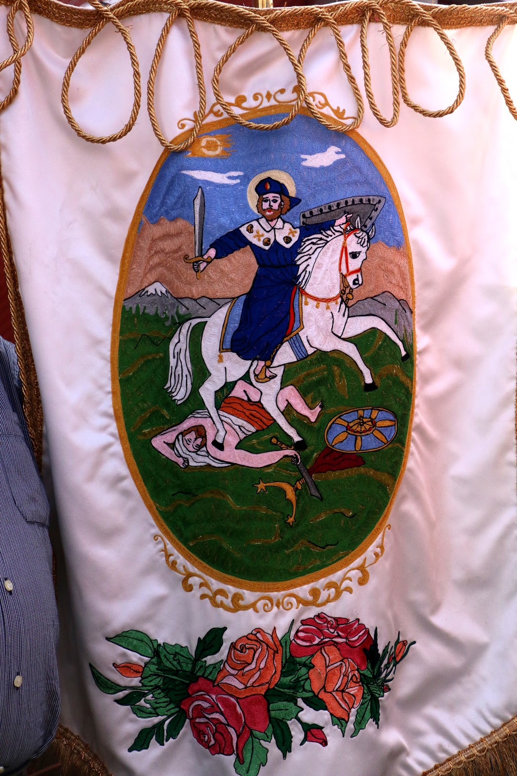
Santiago Matamoros,
 St. James the Moor Slayer,
the disciple of Jesus who,
according to legend,
 traveled to the Roman province of Iberia
to founded Christianity in the 1st century CE.

 According to Spanish Catholic belief,
he miraculously returned
800 years later to help expel Muslims,
a "reconquest" completed in 
1492,
thus bringing into being the full
Kingdom of Spain.

Santiago is, thus, he who defeats pagans
in defense of Spanish Christianity;
Hence, he became a symbol 

to the indigenous
peoples of the New World,
to convert or else...

He is very popular
in Mexcian Catholicism.


Santiago
Accompanied by Modern Superheroes
(Our personal favorite)

Two doncellas, maidens,
precede the ultimate maiden

The Virgin (Mary) of Candelaria,
with el Niño Jesús, the Infant Jesus.
Her Feast Day is February 2, forty days after Christmas.

Even younger innocents precede another Virgin Mary

Another Virgin of Candelaria
(One or more Virgins Mary are always
in a procession of saints,
no matter the primary saint being honored,
even when it is Her Son.

The Virgin of Guadalupe,
Mother of Mexico

Finally, saints are also represented in paintings

The procession returns to the atrio of the church.
A celebration of the Mass will follow.

Quema de Salva, A Salvo of Cohetes.


The procession will be followed, as they always are, by a Mass dedicated to the saint of the day, this time, the Divine Savior. But we have seen on the fiesta announcement that before the Mass there is to be a quema de salva, a long series of exploding of cohete firecrackers — a kind of military-style salute to the saint of the day. Often this is done from the roof of the church or a building attached to it. 

We see no sign of anyone on the roof, so we ask one of the parishioners where it will occur, so we can find the best position for taking photos. He tells us it is about to take place in the street behind the church, so we hurry out of the atrio and around toward the rear. On the way, we pass a small plaza — the kind that is usually in front of a church atrio, so we hadn't seen it when we arrived earlier in the day. At the near side is a large, very formal metal sign providing what is evidently some historical information about Nextipac. We certainly want to learn what it has to share.

But we will have to return to read the sign later because la salva is beginning. Young men are hurrying from a building at the rear, carrying bunches of cohetes to other men in the street behind the church. There, these men are handing them one at a time to still others who light them — one after another — as fast as possible. The noise is, of course, deafening. Surely, the saints and the Trinity above hear it. The street is full of smoke.

Quema de salva


Returning to the Foundations of Nextipac


When the quema ends, relative calm and quiet return, and the smoke begins to clear. We go back to the side of the church to explore the plaza and to read the information on the sign about the history of Nextipac.


The sign's information is in two sections. The first is headed, "Summarizing Efforts to Investigate and Conserve Your Heritage" It reads:
"In the year 2014, with the purpose of remodeling the main plaza of the pueblo of San Juanico Nextipac, researchers from the National Institute of Anthropology and History, with the support of the neighbors of Delegación Iztapalapa, carried out archaeological excavations and succeeded in recovering valuable information about Nextipac's past.
"They were able to record various structures used for habitation that date from the prehispanic epoch: stucco floors, possible remains of a platform, an offering, a fireplace and buildings of adobe (clay).
The archaeological materials recovered are of ceramic, stone, shell and bone. They take us back not only to a prehispanic occupation that goes from 900 [CE] to 1519 [year Hernán Cortés and his Spanish soldiers entered the Valley of Mexico], but also to an important occupation that continued after the Spanish conquest in 1521 until our days."  
The illustrations in red to the right side of this first section represent some of the objects found.

The second section is headed:  "The Roots of Your Barrio: the Archaeology of San Juan Nextipac". It reads:
"Here, below this park and among ancient pipes, cables and tree roots, were found the remains of houses from the prehispanic epoch. Their location, the materials used, the used objects and objects recovered permitted the archaeologists to infer that their inhabitants were families of a high social level.
"In that epoch it was common to place buried persons as offerings below the floors of constructions. Because of this, it was not strange that during the excavations the archaeologists discovered two burials of children, each of them placed in two small, circular pits created with stucco floors. 
"The remains of one infant were inside a pot covered with a top allowing the burning of incense. The other minor was placed directly in the pit in a seated position, with a pottery bowel over its skull."
The illustration in red to the left of this section portrays the outline of the habitation and the location of the two circular graves below its floor.

Reading the sign standing in the little plaza of San Juanico Nextipac, we feel a sense of awe and respect, as if we are virtually standing in the pueblo of the past. We are standing where in the early 1300s the Mexica stayed for four years as they neared the end their pilgrimage to find a home of their own on another island, farther north in Lake Texcoco.

Now, from this brief but informative sign, we know that the island was inhabited at least four hundred years before the Mexica arrived and not just by simple, common people, but by people "of high social level". We deduce that they were likely from nearby Culhuacán, which had already been occupied by the Tolteca Culhuas for three hundred years prior to the building of the houses, and they dominated the area.

And as the sign says, evidence was also found of the pueblo's continuous habitation from 900 CE up to the Spanish Conquest, and on to modern times. So we wonder how descendants of the occupants of these original homes interacted with the itinerant Mexica, and again, two hundred years later, with the Spanish when they arrived.

Finally, we do know that sometime in the 16th century, the Franciscans arrived and built the first chapel where the present church sits, immediately beside the plaza, and dedicated the pueblo of Nextipac to St. John the Baptist.  The congregation they established among the residents still exists and continues to celebrate its existence and identity with lively and frequent fiestas.

And somewhere nearby, below the recently renovated plaza, are the graves of two children buried over one thousand years ago,

To the left side of the church door is a stone or molded cement plaque: 
The glyph, as in the Nahua year count, represents a House or Clan 
sitting atop ashes.
Nextlicpac, Over the Ashes


Delegación Iztapalapa (light green)
sits on the mid-east side of Mexico City.

Delegación Iztapalapa,
with all its pueblos (original villages) and colonias (modern developments).


San Juanico Nextipac sits in its northwest corner. 
It is the very small, dark blue, narrow rectangle
just above its name (in yellow).