Showing posts with label Valley of Mexico. Show all posts

Wednesday, December 8, 2021

Welcome to Mexico City Ambles: Navigating the Blog

Welcome to Mexico City Ambles! Here we seek to present "el imaginario", a vision of the city as embodied in its cityscape, public art and neighborhoods (pueblos and colonias). Over time, as we sought to discover the physical and historical breadth and depth of the City, our search led us to focus on the life of its lesser-known, working-class neighborhoods, many of which were indigenous pueblos existing long before the Spanish arrived and took over 500 years ago. We visit these original pueblos when they are celebrating their traditional fiestas, which are lively, colorful celebrations of their centuries-long communal continuity and unique identity.

¡Bienvenido a Paseos por la Ciudad de México! Aquí buscamos presentar el imaginario, una visión de la ciudad como encarnada en su paisaje urbano, arte público, pueblos y colonias. Si bien buscamos cubrir la amplitud y profundidad física e histórica de la ciudad, nos ha llevado a centrarnos en en la vida de sus pueblos y barrios menos conocidos, muchos de los cuales eran pueblos indígenas que existían mucho antes de que los españoles llegaron y se hicieron cargo desde 500 años. Visitamos estos pueblos originales cuando celebran sus fiestas tradicionales, que son celebraciones coloridas y animadas de su continuidad comunal por siglos y su identidad única.

Escribimos en inglés porque somos norteamericanos y para dar a conocer a otros norteamericanos y hablantes de inglés la ciudad más allá de los lugares turisticos típicos. Sin embargo, es fácil traducir una página en español: vaya a la columna a la derecha. En la parte más alta hay una ventana etiquetada "Translate". Desplace la flecha abajo hasta encuentra "Spanish". Click en ese y inmediatamente todo el texto estará traducido en español por Google. Con certeza, habrá varios errores, pero creemos qué el sentido se quede bastante claro.  

Organization of the Blog
  • Each post appears in the blog chronologically by publication date. 
  • Scrolling down from this introduction takes you to the most recently published post. 
  • Most posts, however, have thematic or geographic connections to other posts. 
  • So, as a navigation aid, we have created individual PAGES (listed in the left-hand column) which organize posts according to major aspects of the city or themes in its history. 
  • These pages provide short descriptions of posts, grouped according to a theme or by geography, with links to all relevant, individual posts.

Setting the Stage | Introductory Pages:


I. Making Sense of Mexico City: The first four pages acquaint you with Mexico City's organization (it does have one, despite its apparent chaotic appearance).
  1. First, we introduce you to its sixteen alcaldías (literally "mayoralties", each governed by an elected alcalde, mayor, and a council) into which the city is divided spatially and politically. 
    The name, alcaldía, was assigned recently, in 2016, when the self-governing legal entity of la Ciudad de México, Mexico City, was established. Initially created in 1928, they were called delegaciones (we use that term in our early posts). They were the components of el Distrito Federal, the Federal District, governed by the federal administration until 2000. The closest English equivalent for these divisions is "boroughs". Each one is distinctive in its physical characteristics, population, and history.

    2. We then address why Mexico City architecture appears to the visitor to be such a hodgepodge of historical epochs and we present a way to view it as a horizontal archeological site, one of multiple eras sitting right next to one another. 

    3. Then we present the history of how the city grew from a small, Spanish Colonial city on an island in the midst of a huge lake to its present huge size (at 573 sq. miles, slightly smaller than Houston [599] but bigger than Los Angeles [469]!). 

    4. Finally, we describe el Metro, the "subway", which is the fastest and cheapest pathway (US25 cents) to get to most of the places we explore. If you avoid morning and late afternoon rush hours, it's fine. Taxis, both pink and white "libres" cruising the streets and white "taxis de sitio" (i.e. waiting at a taxi stand), are licensed, plentiful and safe. Now Uber and other phone-ap car services are here. 

  • Mexico City's Sixteen AlcaldíasMexico City is shaped rather like a lumpy pear: skinny at the top—it even has a "stem"—then rounds out to a very fat bottom. Originally called the Federal District, in 1928, it was divided into sixteen delegaciones, or boroughs, of greatly varying sizes, shapes, population densities and histories. On January 1, 2016, via federal law, el Distrito Federal, the Federal District, officially became Mexico City and the delegaciones were renamed alcaldías, mayoralties.
  • Making Sense of Mexico City: Architectural Hodge-podge or Horizontal Archeological Site?Your first experience of Mexico City is likely one of an architectural hodge-podge, an incoherent batiburrillo, a jumble of buildings from various eras. This is especially true, if, as a tourist, you visit el Centro Historico, where Spanish conquistador, Hernán Cortez, began to build la Ciudad de México on top of the destroyed city of the indigenous Mexica (aka Aztecs), Tenochtitlan. Structures from the colonial period, adapted to contemporary uses, are enmeshed with newer neighbors from the 19th, 20th and 21st centuries. So what to make of this hodgepodge of eras, these fragments of disconnected history, this batiburrillo
  • How Mexico City Grew From an Island to a MetropolisHow did Mexico City, which started on an island in Lake Texcoco— replacing the Mexica (aka Azteca) altepetel (city-state) of Tenochtitlán—grow into the metropolis it is today, incorporating both ancient and new neighborhoods, side by side, all parts of the contemporary batiburrillo (hodgepodge)? Here is the story.
  • Mexico City Metro: The Mexico City Metro (officially, the Collective Transportation System) is a network of subway and surface electric train lines enabling chilangos (city residents' name for themselves) and visitors to get around the city quickly, cheaply (US25 cents) and safely. The system has 12 lines, each distinguished by a specific color on its signage, making changes from one line to another easy. There are also multitudes of taxis, both libre (cruising and painted pink and white) and de sitio (waiting at assigned locations and painted white) and yes, they are both safe. Now, of course, there are also Uber and other phone ap systems for calling a private chauffeur.

II. Mexico City's Natural Environment: The next set of pages acquaint you with the city's special natural environment: 
    • its year-round temperate, sunny climate, 
    • its history as a valley filled with large lakes, 
    • its spectacular geological setting in the midst of a circle of large, mostly dormant volcanoes, and 
    • its smaller, but historically important volcanoes within the city.
  • Mexico City Climate: Seasons, Sun, Sky, Clouds and Rain: If you are looking for a place to live year-round, permanently, as we do, or just to "winter" in Mexico, our advice is to head for the hills. The "hills" are comprised of the high plateau of Central Mexico known as el Bajío and the cross-country mountain chain just to its south, called the Eje Volcánico, the Volcanic Axis or Trans-Mexico Volcanic Belt. This area has year-round moderate temperatures because it is located more or less around 7,000 ft. above sea level, which keeps the climate quite stably moderate and usually sunny.
  • Mexico City sits at 7,000 ft. altitude. Here is our account of the City's mild climate: its seasons (there is no real winter), the sunshine (which occurs most days), the sky (which can be unbelievably blue), the clouds (which can be dramatic towering cumulus), and the rainy season, more or less from May to October. Don't worry, it doesn't rain every day and usually, it's in the late afternoon or after dark and consists of brief, at times intense, thunderstorms. They serve as natural airconditioning and air purifiers, keeping the summer air dry, the temperatures moderate during the day and cool at night and, usually, with clearer air.
  • City of Lost Lakes, Islands, and VillagesThe Valley of Mexico, now filled by urban sprawl, was originally nearly filled by a chain of five lakes (covering about 580 sq. miles). Lake Texcoco was the largest, most central, and lowest of them, thus receiving water from the other four. Because of the surrounding mountains, they had no outlet to the sea, and Texcoco was salty. The original Mexico City and its predecessor, Mexico Tenochtitlán, were on an island in a large bay in the southwest corner of Lake Texcoco. In addition, there were hundreds of villages that occupied the land around the lakes, as well as many on islands in the lakes.
    Over the centuries, the lakes have been almost totally erased since the Spanish began draining them in the 17th century to prevent the annual flooding of Mexico City during the summer rainy season, so the islands eventually became part of the mainland. We have been searching out these "lost" islands, which are still-existing pueblo neighborhoods within the city. Here we introduce the ones we have visited and the history of the changes they have undergone from islands to urban neighborhoods.

    Five original lakes of the Valley
    with some of the major cities and villages
    around them and on their islands.
    Note Tenochtitlan's location 
    at the entrance to a bay 
    in the southwest of Lake Texcoco.

  • Encountering Mexico City's Many Volcanoes, Part I: Giants on All Sides: Mexico City, as most everyone knows, sits in and takes up most of the Valley of Mexico. It is, in fact, a spectacular valley because it is surrounded by tall mountains, all of them volcanoes. 
    • Only one, Popocatepetl, (The Smoking Mountain), the tallest at nearly 18,000 ft (more than 10,000 feet above the Valley floor) is active, regularly emitting a plume of steam and sometimes erupting with huge columns of ash and lava. 
    • Popo, as he is familiarly called, is joined by his beloved frozen princess, Iztaccihuatl (The White or Sleeping Woman), at 17,000 ft. 
    • However, they are only the tallest and most dramatic members of the ring of volcanoes that surround the Valley. Here is an introduction to the many giants that envelop the city and make its geographic setting unique.
To the left is Iztaccihuatl
To the right is Popocatepetl
(as seen from Alcaldía Coyocán; they are forty to fifty miles southeast)
  • Encountering Mexico City's Many Volcanoes, Part II: Little Volcanoes With Big Histories: While the huge volcanoes of Popocatépetl, IztaccíhuatlAjusco and the others in the Cordillera de Chichinautzin, the Sierra de las Cruces and the Sierra del Río Frío, which create and dominate the Valley of Mexico and grab the interest of residents and visitors when they are in clear view, there are other volcanoes right within the city´s limits. They are small ash cone volcanoes, but despite their diminutive size, at least four of them have played prominent roles in the development of human settlements in the Valley and thus in the history of Mexico City. Here is our introduction to the four.
Cerro de la Estrella, Hill of the Star
Called Huizachtecatl (in Náhuatl) by the Mexicas.
  • Mexico City Architecture: This group of pages focuses on the architectural qualities which predominate, particularly in the Cento Historico of the city, the original Ciudad de México which Hernán Cortés began to build on top of the indigenous altepetl, México-Tenochtitlan of the Mexica.
  • Grandeza Mexicana: Grandeur of Mexico CityWalking the streets of Mexico City, from its Centro Histórico to various of its late 19th to early 20th century colonias, (planned neighborhoods) and modern boulevards, acquainting ourselves with their architecture and public art, we have noted the recurrence of what becomes a visual theme: an architectural grandness that relays a message of wealth and power. This city has been, and is, a seat of major political and economic power, expressed through physical grandeza, grandeur. Here we explore the particularly Mexican roots of this impulse to grandeur.
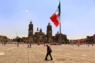
Zócalo
Main Plaza

second largest plaza in the world, 
after Red Square in Moscow.
  • México Barroco | Baroque Art: Representing Divine Ecstasy, Evoking AweIn Mexico, the art of the Baroque epoch (mid 17th to mid 18th centuries) is all around you in Centro and in many of the old churches throughout the city. It is the art of the height of the Spanish Empire, and it realized its most elaborate form in Nueva España. An excellent Wikipedia article on the Baroque helped us see its character as centered on grandeur, lavishness, and drama. We also came to realize the goal of its religious forms was to express holy ecstasy (stepping outside the ordinary world) and evoke awe. With that perspective, we explore the central and quintessential expression of Baroque religious architecture in Mexico City, the Metropolitan Cathedral. There are innumerable other examples in churches around the city.
El Sagrario
The Tabernacle portion of
the Metropolitan Cathedral,
in high Baroque style

IV. Thematically or geographically related pages

  • Mexico's History As Embodied In Mexico City: Lists and links to all posts addressing the many stages in Mexico City's history as they are manifested in the cityscape, from the indigenous reign of the Mexica/Azteca through the Spanish colonial period (1521-1821), and the 19th and 20th centuries, up to the Mexican Revolution (1910-17) and its aftermath. 
Chapultepec Castle,
scene of several significant events
of the 19th century.
  • Mexico City's Original Indigenous Villages and Their Spíritual ConquestContemporary Mexico City is an amalgam. It's core is the Spanish Colonial Centro. It did not significantly expand beyond that until the late 19th century. Then, in the second half of the 20th century, it exploded with rapid urbanization of previous lakebed and rural land. In that relatively recent explosion, it swallowed up ancient indigenous pueblos. These are villages, that, beginning some three thousand five hundred years ago, were established on the shores and islands of the five lakes at the center of the Valley of Anahuac. So Cortés and the Spanish not only had to transform Tenochtitlan, they also had to transform a geographically extensive civilization and culture via the "evangelización de los indios," or "los natuturales", what has been called the Spiritual Conquest. This series of posts explores the churches, neighborhoods and fiestas that continue to embody that encounter and the synthesis of the two civilizations. (This is our current work-in-progress).
Original, 16th century chapel of San Francisco,
in Quadrante (Quarter) of San Francisco,
originally the indigenous village of 
Hueytetitlan, now in Delegación Coyoácan.

  • Centro: El Centro, the Center of Mexico City, actually consists of five colonias, or neighborhoods: Centro Histórico, and East, West, North and South Centro. Spanish colonial palaces and smaller residential and commercial buildings from that period are numerous, but mixed in among them are buildings from the 19th and 20th centuries. Within them, and flowing among them in the streets, is the everyday, timeless activity of selling and buying.
Portable shoeshine stand
in Plaza 
de Santo Domingo
  • Chapúltepec Woods and Paseo de la Reforma: Five kilometers, three miles, southwest of Centro, on what used to be the western shore of Lake Texcoco, sits the ancient, sacred site of el Bosque de Chapúltepec, Chapultepec Woods. It was the first place that the Mexica/Azteca tried to settle down near the end of the 13th century, and later their royal retreat and source of fresh spring water for Tenochtitlan. The Spanish turned it into a park for themselves and continued to depend on its freshwater springs. 
Subsequently, a "castle", actually a palace, was built by a viceroy (ruling representative of the king of Spain) at the top of its landmark hill, an ancient ash cone volcano. After Independence was won from Spain in 1821, it served as the Mexican Military Academy and, in 1847, it was the scene of the last battle in the U.S. invasion of Mexico (aka Mexican-American War). In 1864, Emperor Maximilian I, put in place by Napoleon III of France at the request of Mexican conservative forces, decided to make it his palace. To connect it with the City Center, he had a boulevard built and named after his wife the Belgian Princess Carlotta. After his overthrow by liberal reform forces led by Benito Juárez in 1867. it became Paseo de la Reforma.
Paseo de la Reforma,
seen from Chapultepec Castle
  • Reign of Porfiro Díaz and Neighborhoods of the Early 20th Century: As the 19th century approached its end, Mexico City's well-to-do, who had increased in numbers under the economic policies of Porfirio Díaz (multiple times reelected president and dictator from 1876 to 1911), sought new residences outside the old Spanish Colonial Centro Histórico. They began to develop colonias, planned neighborhoods, to the west, along Paseo de la Reforma boulevard, and to its north and south. Díaz and the well-to-do had a great admiration for French culture. Hence, these colonias have a French flavor. Posts on six of these neighborhoods, with introductions, are listed.
French Second Empire-style homes,
with characteristic mansard roofs.
  • Mexican Revolution: Overview of Its Actors and Chapters: The Mexican Revolution (1910-1917) was a watershed between traditional and modern Mexico. Actually, a series of four civil wars fought between a diverse cast of characters with widely disparate histories and motivations, the war and its turbulent aftermath can be divided into five stages or chapters, each consisting of a number of critical episodes. This Page offers an overview of the war and links to Pages with fuller accounts of the personalities and each chapter of the war and its volatile aftermath.
Monument to the Revolution
  • Mexican Muralists: During the Mexican Revolution, a revolution in Mexican Art was triggered. After the Revolution, it unfolded in a group of buildings in Centro and expanded across the city throughout the 20th century. This page provides links to posts on the sites and their murals—works by the "Big Three": Diego Rivera, José Clemente Orozco, David Alfaro Siqueiros, and their successors, who continue to produce works up to the present.
Mural of Cortés and Malinche,
representing the mixing (mestizaje)
of Spanish and indigenous peoples.
by José Clemente Orozco,
in the museum San Ildefonso.

Friday, July 26, 2019

Tenayuca and Acatitlán, State of Mexico | Remnants of Indigenous Civilization in the Valley of Mexico

Ambling Beyond Our Normal Bounds


In this amble, we go beyond two of our usual boundaries — the one that focuses us on the still-vital, originally indigenous pueblos and barrios of Mexico City and the boundary of the City, itself. We go a short distance north and west of the City's most northern delegaciones/alcaldías, Azcapotzalco and Gustavo A. Madero, into el Estado de México, the State of Mexico, which surrounds the City like a lopsided horseshoe on the west, north and east. Our destination is two Mesoamerican archeological sites, Tenayuca and Acatitlán.

Our opportunity to visit the sites was provided by Arqueología viva México, led by archeologist Gerardo Orozco, who, via its Facebook page, organizes excursions to sites in and around Mexico City, as well as elsewhere in Mexico. We have wanted to see Tenayuca and Acatitlán since our early days in Mexico City, but were not able to negotiate the complexities of public transportation, via Metro and Metrobus, to get to the sites on our own. Sr. Orozco led the way, as well as sharing his professional knowledge of the sites.

Via Metrobus, we cross into the State of Mexico, an invisible line obliterated by the continuous, modern urban sprawl that has spread from the city and filled the Valley of Mexico since the late 20th century to form the Greater Mexico City Metropolitan Area. Crossing the line, we recall that before the huge expansion of the boundaries of the former Federal District in the mid-19th century, much of what is now part of the City belonged to the State of Mexico.

After Mexican Independence was won in 1821, the new government initially defined the state's boundaries to be the same as they were as a province under the Spanish. The state and preceding Spanish Province of Mexico encompassed a much larger territory than the present state. It included what are now the states of Hidalgo, to its north, and Morelos and Guerrero to its south, which were created in 1869 by President Benito Juárez. (See our page: How Mexico City Grew From an Island Into a Metropolis.)

File:Mexico (state) in Mexico (zoom).svg
The State of Mexico
is the red area.
Mexico City is the small, white triangular shape within its embrace. 

The state of Hidalgo (large) is to the north.
The states of Morelos (small) and Guerrero (large) are to the south.
Wikipedia

Boundaries in the Valley Before the Spanish Arrived


Thus, the boundary between Mexico City and the State of Mexico is highly arbitrary. The natural boundary is made up of the mountains that surround and form the Valley of Mexico (See our post: Mexico City's Many Volcanoes, Part I: Giants on All Sides). When Hernán Cortés, his troops and indigenous allies he had made while traveling west from Veracruz on the coast of the Gulf of Mexico arrived in the Valley in November 1519 (five hundred years ago this year), he found it filled with hundreds of indigenous cities, villages and hamlets, all interconnected parts of one socio-cultural, civilized, Nahuatl-speaking world.

They were not however, what historians traditionally called the "Aztec Empire". The Valley was politically and economically divided into eight tribal altepetls, city-states. Among these eight entities, the Mexica/Azteca altepetl, based in the city of Tenochtitlan, on an island in a southwest bay in Lake Texcoco, was only one among many. Moreover, it had been the dominant altepetl for just under a hundred years, since 1428. Before that, various others of the altepetls had striven for and been dominant for various periods of time since the Nahua tribes had entered the Valley between the 7th and 13th centuries.

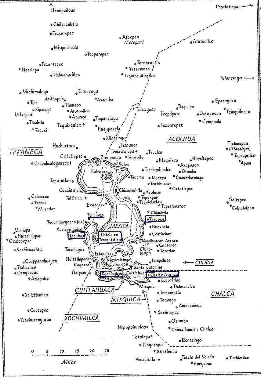
Tribal boundaries in the Valley of Mexico
at the time of the arrival of the Spanish in 1519.
From Gibson, Charles, The Aztecs Under Spanish Rule,
Stanford University Press, 1964.

The Triple Alliance


Three of the altepetls were the most powerful, having formed the Triple Alliance in 1428. It was this Triple Alliance that constituted what has been called the "Aztec Empire". In 1519, it dominated the other altepetls in Valley and other tribal city-states far beyond the Valley in what is now central Mexico. All the others paid tribute to one or another of the three. The Mexica of Tenochtitlan were the most powerful of the three and received the most tribute, but the other two were autonomous in regards to their internal government. They were the:
  • Acolhua, with their capital at Texcoco, on the east side of the lake. The second most powerful member of the Alliance, they did not pay tribute to the Mexica. Its territory is now in the State of Mexico.
  • Tepaneca, with their capital at Tlalcopan (called Tacuba by the Spanish), on the west side of the lake. Tacuba is now the cabecera, government headquarters, of  Delegación/Alcaldía Miguel Hidalgo in the City of Mexico.
The Triple Alliance was formally created after the Mexica, the Acolhua and the leaders of the Tepaneca town of Tlalcopan defeated the Tepaneca rulers in 1428. The Tepaneca had been the dominant force on the west side of Lake Texcoco for more than a hundred years. Their capital had been Azcapotzalco, which was destroyed in the war, so the capital was then moved a short distance south to Tlalcopan. They thereafter remained subordinate to the Mexica, but the rulers of their towns were allowed to continue to control internal matters and collect tribute — part was used to support themselves and part was shared with Tlalcopan.

The Other Altepetls


Two other large tribal groups were the 
  • Xochimilca, in the south, with their capital at the island city of Xochimilco, on the lake of that same name. They were among the earliest Nahua tribes to settle in the Valley, around 900 CE. They had been defeated, in turn, by the Culhua (see below) at the end of the 13th century, by the Tepaneca in the 14th century and, finally, by the Mexica in the early 15th century and their territory reduced. Their capital is now the cabecera of Delegación/Alcaldía Xochimilco.
  • Chalco, to the southeast, with their capital at Chalco-Atenco on the east end of Lake Chalco.  They were subjugated by the Mexica but rebelled from time to time. It is now a municipality in the State of Mexico.
Three smaller but still distinct tribes completed the population of the Valley. They were the
  • Culhua, with their capital, Culhuacán, at the west end of the Iztpalapa Peninsula, between Lakes Xochimilco and Texcoco. They had been a dominant force, controlling more territory, until they were defeated first by the Tepanecas in the 14th century, then by the Mexica in the 15th century. Culhuacán was then left controlling only three other towns, Iztapalapa and Mexicaltzingo on the tip of the peninsula, and Huitzilopochco (now the barrios of Churubusco), across the channel connecting the two lakes, in what is now Delegación/Alcaldía Coyoacán. Culhuacán is now divided into Pueblo Culhuacán in Delegacion/Alcaldía Iztapalapa and the adjoining Pueblo San Francisco Culhuacán in Coyoacán.
  • Cuitlahuaca, whose capital occupied an island dividing Lake Chalco from Lake Xochimilco. They never controlled much territory beyond a few nearby towns on the north and south lakeshore. It is now the cabecera of Delegación/Alcaldía Tláhuac (a shortened form of Cuitlahuac) which includes the pueblos it formerly controlled. 
  • Mixquica, whose capital, Mixquic, on the south shore of Lake Chalco was all they controlled. It is now Pueblo San Andrés Mixquic incorporated into Delegación/Alcaldía Tláhuac.
In 1521, Cortés' Spanish soldiers, together with indigenous allies both from within and outside the Valley, defeated the Mexica of Tenochtitlan and then went on to take control of all of the Valley, either by might or the voluntary submission of the other tribes. From Gibson, Charles, The Aztecs Under Spanish RuleStanford University Press, 1964.

Tenayuca


Tenayuca means "walled place" in Nahuatl. The archeological remains of Tenayuca are located in the originally indigenous Pueblo San Bartolo Tenayuca in the municipality of Tlalnepantla de Baz, in the State of Mexico. At the time the Spanish arrived, it was under the control of the Tepaneca (see above map of tribal territories), which it had been for some time before the Mexica became "the first among equals" in the Triple Alliance.

Tenayuca
lay at the northern-most end of the southwest bay
of Lake Texcoco.
During the time of Mexica/Azteca rule,
it was at the end of a long causeway
from Tenochtitlan/Tlatelolco.

Archaeological remains recovered from Tenayuca indicate that the site was first occupied in the Classic Period (100 to 600 CE), when Teotihuacan, in the northeastern part of the Valley, dominated the area. Its population increased in the early Postclassic (600-1100 CE) during the reign of the Tolteca based in Tula, outside the valley to the northwest.

It continued to increase after the fall of Tula (1150 CE), when, with the lack of a central dominating power, many nomadic tribes, generically called "chichimeca" [a pejorative term used by settled, agrarian peoples with urban centers, hence, "civilized", to denote nomadic hunter-gatherer tribes from the north] moved through the area formerly controlled by Tula and entered the Valley that was called Anahuac.

According to the Codex Xolotl, Tenayuca, itself, was founded in 1224 CE by Xolotl, ruler of a Nahuatl-speaking chichimeca tribe whose actual name is unknown. Xolotl was succeeded by Nopaltzin who married Atototztl, a Tolteca princess, in order to establish a linkage with the royal lineage of Tula, seen by all the new tribes as the epitome of a civilized society. When Nopaltzin died, his son, Quinatzin, transferred the seat of power to the east side of the lake that came to be known as Lake Texcoco and founded the altepetl (city-state) of Coatlichán. Quinatzin left a maternal uncle, Tenacacaltzin, to be lord of Tenayuca.

On or about 1337, another tribe, the Acolhua, defeated the chichimeca of Coatlichán and made Texcoco their capital city (see map of tribal boundaries above). Tenayuca allied itself with the Acolhuaswho dominated the northeast region of the Valley of Mexico in the mid-14th century.

However, in the late 14th century, Tenayuca was conquered by the Tepaneca of nearby Azcapotzalco. About a hundred years later, in the 1430s, after the Mexica of Tenochtitlan and their allies, the Acolhuas and Tlalcopan, conquered Azcapotzalco, bringing the Tepaneca under the control of the Triple Alliance, Tenayuca came under the control of Tlalcopan. It remained so until the Spanish came and conquered the entire Valley in 1521 (modified from Wikipedia).

The Temple of Tenayuca


Temple architecture that was built during the period of Mexica/Azteca dominance is based on that which originated at Tenayuca. It consists of a pyramidal base supporting two temples. The Mexica/Azteca adopted this innovative style for their own main temple, now known as the Templo Mayor, in the center of what was Tenochtitlan.

Pyramid of Tenayuca
with its stairway leading to what were two temples.

The archeological site consists of a massive pyramidal platform with a stairway rising on the western side to where the twin temples of Tlaloc (god of all waters, essential for agriculture, the basis of urban civilization) and Huitzilopochtli (son of the sun god, Tonatiuh and god of war, the Mexica's primary god) once stood. The temple of Tlaloc occupied the northern part of the pyramid while the Huitzilopochtli temple stood to the south. To the south of the stairway at ground level is a projecting platform bearing sculptures of crossed bones and projecting skulls. It is likely where human sacrifices were carried out or completed after being initiated in one or the other of the temples above.

Southwest platform of skulls and crossed bones.

Like many Mesoamerican temples, various phases of construction were built one on top of the other. In the case of Tenayuca, the size of the building increased through six phases of construction but the basic form remained unchanged. The original double pyramid was enlarged five times, the first time probably in 1299 and then successively at 52-year intervals [the cycle of the "tying of the years", when the first day of the 365-day solar calendar coincided with the 260-day divinatory calendar].

The last phase of construction probably dates to 1507 and measures 62 meters (203 ft.) wide by 50 meters (164 ft.) deep. Mexica/Azteca influence is apparent from the third stage, built in 1351, only twenty-six years after they founded Tenochtitlan. All the following stages were purely Mexica/Azteca in style, as demonstrated by the sloping, multiple tiers of the pyramid rather than the vertical walls apparent in the earlier stages.

Stages of enlargement of the pyramid
On-site Museo Xolotl

Painting of how the pyramid looked at its final stage in the early 16th century.

Wall of the Serpents


The pyramid base is surrounded on three sides by its most notorious component, a coatepantli (Nahuatl for a wall of serpents), a low platform supporting 138 stone sculptures of snakes. Their bodies were once covered with plaster and painted in a variety of colors, with their scales painted black.

Coatepantli, the Wall of Serpents


On the north and south sides of the pyramid, at ground level, are two sculptures of coiled serpents. The crests on their heads bear markings representing the stars and identify them as Xiuhcoatl (the fire serpent). All the serpent sculptures around the pyramid were associated with worship of fire and the sun.

Fire Serpent

Fire Serpent

Two hundred meters (about 220 yards) from the main pyramid of Tenayuca are the remains of what appears to have been an elite residential complex, with surviving plaster floors in some rooms. This area has been labeled Tenayuca II by archaeologists and appears to have gone through various phases of construction. Wikipedia

Acatitlán


About three kilometers (a little less than two miles) from Tenayuca, in the Pueblo of Santa Cecilia Acatitlán, is another archeological site. It consists of a small, reconstructed pyramid that was originally one of the earlier stages of construction that became enclosed within a larger pyramid. It was reconstructed in the 1960s. 

Pyramid of Acatitlán

Acatitlán was evidently a site subsidiary to Tenayuca. It is believed that after the Mexica took control of the area in the 15th century, the temple was dedicated to their god, Huitzilopochtli.

While we were visiting the site, there was a man standing on top of the pyramid, engaged in an indigenous ritual of venerating the four cardinal directions, the sun and heavens above and the earth below. 


On the man's T-shirt would appear to be the symbol of
the Mexica/Azteca Stone of the Five Suns,
representing the sequence of five creations of the world
until the Fifth Sun,
when humans with language were successfully
created by the gods, so they could worship those gods. 

Like virtually all indigenous temples in Mexico, this one was destroyed by the Spanish. The stones of the outer layers were used to construct the church of Santa Cecilia Acatitlán, which stands nearby. So here, in Acatitlán, we encounter a rare literal demonstration of the so-called Spiritual Conquest, the transformation of indigenous society into a Catholic Hispanic one, which we have been exploring since 2016.  

Church of Santa Cecilia Acatitlán,
built in the 16th century.

Wikipedia

A Glimpse at Indigenous Civilization in the Larger Valley of Mexico


Since we began our ambles in 2015, we have stayed within the boundaries of Mexico City for practical reasons of proximity and preservation of our limited energy. We have been well aware that there are still existing originally indigenous villages and archeological remains outside those arbitrary boundaries, all over the larger Valley of Mexico. We have, of course, been to the monumental site of Teotihuacan, one of the premier archeological sites in the entire world. It is located in a side valley to the northeast of the main Valley. Twenty-five years ago, during our first visit to Mexico, we went to the smaller, but still impressive site of Tula

Today, in our visit to Tenayuca and Acatitlán, we have encountered smaller sites, but ones barely outside the City. They are also sites that, unlike Teotihuacan and Tula, were still functioning communities when the Mexica/Azteca became the last people to dominate the Valley before the Spanish Conquest brought Mesoamerican civilization to an end. The Mexica/Azteca of Tenochtitlan took note of their strategic location at the north end of the bay which their city dominated in Lake Texcoco (see map of bay above) and incorporated them directly into their urban structure via a causeway connecting them to their capital. 

The archeological reconstructions of their prehispanic pyramids, set within the still-vital pueblos of Pueblo San Bartolo Tenayuca and Santa Cecilila Acatitlán, provide — like the Templo Mayor in the midst of Centro Histórico and the site of Tlatelolco, next to the Church of Santiago Tlatelolco — glimpses of the indigenous world that existed before its military Conquest by the Spanish and vivid examples of the dramatic transformation of that world that was the Spiritual Conquest that followed.

Monday, June 11, 2018

Encountering Mexico City's Many Volcanoes, Part I: Giants on All Sides

Giants of Nature Reveal Themselves: Iztaccíhuatl and Popocatépetl


When we were signing our first lease on our apartment in Delegación Coyoacán, in late July 2008the owner of the condominium surprised us when she told us, "You know, on clear days you can see the volcanoes Iztaccíhuatl and Popocatépetl from the living room."

We had been in the fifth floor apartment, in Colonia Parque San Andrés, two or three times to meet the real estate agent, view it and sign an intention to rent it. Among its features we loved was the huge, floor to ceiling, nine-foot wide window in the main room, with a balcony for plants outside, lots of trees across the street and no tall buildings to block the morning sun.

We had once lived in an apartment in Manhattan that faced north. While it was a great apartment, there was no sun, ever, so light in a city apartment was one of our concerns in moving to Mexico City. However, through the huge window, we had never seen a sign of any volcanoes (summer is the rainy season, marked by large cumulus clouds forming in the East in the afternoon).

We moved into the apartment in early August, but because of clouds, we still saw no volcanoes. Then, one afternoon, about 5:00 pm, we were sitting in our living room, having a glass of wine and watching the towering cumulus clouds building dramatically to the East. They boiled higher and higher, growing darker and darker. Lightening began to discharge from them. A strong wind began to blow from the East. We could see the rain arriving over a small hill a few miles away. Soon, we were enveloped in a torrential tropical downpour.

Towering cumulus clouds (cumulus congestus) build to the East in the Valley of Mexico
on a summer afternoon, during the rainy season.

After twenty minutes or so, the storm was over and the clouds began to clear. We were stunned by what was revealed before our very eyes!

Snow-covered Volcán Iztaccíhuatl began to reveal itself.
(This and all following pictures are telephoto shots from our apartment in Delegación Coyoacán)

Iztaccíhuatl, "The White Woman" in Nahuatl, 
called La Mujer Dormida, the Sleeping Woman, in Spanish, 
is actually a massif of volcanoes.
Her "head" volcano is to the left. The tallest volcano forms El Pecho, her "breasts".
Her "legs", other volcanoes, descend to the right (south).
She is familiarly called just 
"Iztac".

El Pecho is 5,230 meters (17,160 ft) in height,
making the mountain the third highest in Mexico
and the eighth highest in North America.

Then, to the south, Popocatépetl began to appear.

Popocatépetl, "Smoking Mountain".
Reaching 
 5,426 meters (17,802 ft), it is the second highest mountain in Mexico
and the fifth highest in North America.

Popo regularly emits a column of steam of various volumes,
hence his name, Smoking Mountain.

Occasionally, "Popo" 
(or Don Goyo, as he is also familiarly called by those who live with him) 
blows his top.
In Spring 2012 and again in 2018, he became very active,
with eruptions of ash and some rocks and lava.

Iztaccíhuatl and Popocatépetl
seen on a clear winter day from our apartment.

They are part of the mountain range called la Sierra de Río Frío.

El Paso de Cortés, Cortes Pass, through which Hernán Cortés and his troops 
entered the Valley of Anahuac in 1519, lies just to left of three-pronged evergreen.
Cortés had some of his soldiers climb Popo at the time.

Legend of the Sleeping Princess and Her Warrior Lover


The Sleeping Princess and the Smoking Mountain have their own version of a creation story or legend. There are several versions of the legend, but all center around a kind of archetypal Romeo and Juliet plot in which a princess, daughter of the ruler of the Valley, and a warrior fall in love but are prevented from marrying because the warrior is sent off to war, either with the ruler's intent that he die (think David and Bathsheeba) or because his rivals for the princess' hand report him killed in battle. 

The princess, hearing her beloved is dead, dies of grief. The warrior returns and, upon finding his beloved dead, carries her body to the mountains and lays her on a bier. Weeping in the cold air, his tears turn to ice. The gods take pity on such true love and turn both into mountains. Popocatépetl continues to spew smoke and, on occasion, lava and rocks out of his ongoing rage, while his princess sleeps. 

Although Iztaccíhuatl and Popocatépetl are forty to fifty miles southeast of Mexico City, they are very important to the identity of chilangos, Mexico City residents. This has been so for centuries.

Central plaza of Mexico City, now known as the Zócalo, in the 18th Century,
looking East. 
The National Palace is at the far side.

Iztaccíhuatl and Popocatépetl are positioned directly behind the Palace,
whereas they are actually well to the southeast. 

Between the Palace and the large volcanoes, the small volcanic chain
of la Sierra Santa Catarina is depicted. It, too, is actually to the southeast,
but within the city limits, forming the border between Delegaciones Iztapalapa and Tláhuac.

The Metropolitan Cathedral is on the left of the plaza.
El Parián market, in the center, was built in 1703,
the first covered 
market in Mexico City.
The Royal Canal, coming from Lake Xochimilco, ends at the right.
Painting in the Museum of Mexico City.

Sierra del Ajusco - Chichinauhtzin


After being awed by the presence of "Popo" and "Iztac" beyond our living room window, we subsequently learned that if we nos asomamos (leaned our head out) our west-facing bedroom window, we had a view of another impressive, and much closer, volcano.

Volcán Ajusco
leaning out our bedroom window, looking south from Coyoacán
about 12 miles, across Delegación Tlalpan.

At 3,930 meters or 12,894 feet in altitude,
Ajusco is the highest mountain within Mexico City,
rising more than a mile above the Valley of Mexico.

Ajusco, like Iztaccíhuatl, is another massif of volcanoes. It lies at the juncture of an east-west volcanic chain, the Sierra del Ajusco-Chichinauhtzin (or just Sierra Chichinautzin), and a northward running chain  called Sierra de la Cruces (the Crosses) along the West side of Mexico City. 


Relief map: Outline of sixteen delegaciones (boroughs) of Mexico City is overlaid 
on terrain of the cuenca, basin, of the Valley of Mexico.

The Chichinautzin Volcanic Range bounds the South. 
La Sierra de las Cruces (Crosses) bounds the West.
Ajusco is the dark orange peak 
at the edge of the West side of Mexico City's largest delegacion, Tlalpan (lower left).

Volcanoes Popocatépetl and Iztaccíhuatl bound the East side of the Valley (off the map)
They are part of the mountain range called la Sierra de Río Frío.
The tan area was formerly lakes and lake-shore land. 

From: la Encyclopedia de los Municípios y Delegaciones de México: Distrito Federal (Mexico City)

Sierra de las Cruces
Ajusco is at the far left.

The Valley of Mexico
and Mexico City 
are surrounded by the Chichinautzin Volcanic Range on the South,
la Sierra de Río Frío, with its Volcanos of Popcatepetl and Iztaccihuatl on the East,
and la Sierra de las Cruces (Crosses) to the West.

Ajusco is left-center. 
(For full screen view, click on the photo.)

All the volcanoes around the Valley of Mexico and Mexico City are part of what is called the Eje Volcánico, the Volcanic Axis, or Trans-Mexican Volcanic Belt, a line of volcanic mountains that crosses lower Mexico, from near Puerto Vallarta, in the State of Jalisco on the Pacific Ocean, to Veracruz on the Gulf of Mexico. 

It is one of the largest volcanic fields in the world, containing well over three thousand volcanoes of various types: tall conical stratovolcanoes (like Popo, Iztac and Orizaba, which is east of the Valley of Mexico); lava domes (like Iztac's "head"); shield volcanoes (flatter because they exude lava slowly), and innumerable small cinder cones (more about these last in Part II, on the small volcanoes within Mexico City).

Volcanic Axis (red) cinches Mexico's midsection;
It contains over 3,000 volcanoes.
Black triangles mark four of the tallest ones: (West to East)
Colima (active);
Popocatépetl (active), linked by a mountain ridge to Iztaccíhuatl (dormant);
La Malinche (dormant 3,100 years); and
Pico de Orizaba 
(active, indigenous name is Citlaltépetl), 
 At 18,406ft.,
 Orizaba
 is the tallest mountain in Mexico 
and the third tallest mountain in North America.

Portion of Ajusco-Chichinautzin Volcanic Range within Mexico City.
Ajusco lies at upper, far-left. 
In addition to the large, named volcanoes, note the many small cinder cone craters 
peppering the landscape. 

Tláloc Volcano
at sunset
It actually has two craters, to the left and right.
Height is 3,690 meters or 12,106 ft.
It lies near the Southeast corner of Delegación Milpa Alta,
in Southeastern Mexico City.

"Frozen" lava flow from shield volcano Cuautzin.
(looking South)
Cuautzin is between Ajusco and Tláloc.
Delegación Milpa Alta is to the left,
Delegacion Xochimilco is lower center,
Delegación Tlalpan is to the right.
Volcán Cuahtzin
A shield volcano, low and flat because its eruptions were slow discharges of lava. 


Living in the Midst of Giants


It is difficult to put into words what one experiences encountering these gaints of nature. We are awed every time Popocatépetl and Iztaccíhuatl appear before our eyes from beyond our living room window. Ajusco, smaller but much closer, also triggers feelings of awe, of wonder. These are the primal human feelings that engendered the belief that these mountains were gods, both protecting and threatening the people of the Valley. When Popo explodes, one feels the world, at least one's immediate one, might be coming to an end. 

It is easy to forget the presence of these colossi when going about one's daily life, surrounded at ground level by the built City. But they are always there, even when hidden by clouds (or, yes, pollution), and every so often, one comes into sight of them, particularly when in the southern delegaciones (boroughs) of Tlalpan, Xochimilco, Tláhuac and Milpa Alta. One may also see them when taking a bus out of the city and the Valley, over the mountains, to Cuernavaca to the south, Puebla to the east or Toluca to the west, or flying into or out of the Mexico City International Airport.  

How to See, and Even Meet, the Giants.


For visitors to the City (and for chilangos, City residents), it is quite easy to see, if not encounter, the giants surrounding the city. One only has to have the luck of encountering one of the (unfortunately) rather rare crystal clear days that mountain air can provide. Then, carpe diem, seize the day, and go to the Torre Latinoamericana, at the corner of Calle Madero and the Eje Central (Central Axis, aka Ave. Lázaro Cárdenas) in Centro Histórico, pay some pesos and take the elevator to the observation deck at the top of this Empire State Building look-a-like.

From the decks—the lower one enclosed by large windows; the upper one open to the air—on a clear day, the entire Valley of Mexico opens in front of one's eyes. Seemingly not so far away to the south is Ajusco, and to the southeast, la Sierra Chichinautzin. To the southeast, farther away, but still awesome in their majesty, rise Popocatépetl and his beloved Iztaccíhuatl

For the more adventuresome, it is possible to go to the Parque Nacional Cumbres de Ajusco, the Ajusco Peaks National Park in Delegación Tlalpan. There, one can drive a circular road around the top, hike or bike on trails and even camp overnight.  

For the even more adventurous, it is possible to go to the Parque Nacional Iztaccihuatl-Popocatepetl and climb, at least up Iztac and the Paso de Cortés. Popo is often off-limits because of his unpredicatble activity. 
One can also encounter volcanoes up close, but now mostly covered by dense and beautiful evergreen forests, in the western, mountainous delegaciones of Álvaro Obregón, Magdalena Contreras and Cuajimalpa. All these delegaciones are, in greater or lesser parts, in la Sierra de la Cruces, which contains eight stratovolcanoes reaching up to 12,700 ft. (3,870 meters). 
El Desierto de los Leones, the Wilderness of the Lions, is a national park in las Cruces, with hiking trails, picnic tables and restaurantes campestres, outdoor restaruants. It is only accessible via car. 
Aside from a wonderful (and full of wonder) visit to El Desierto and its former Carmelite convent (monastery), we have not yet managed to get to these western delegaciones in our Ambles. We can, nevertheless, see parts of them from our bedroom window.
See also: Encountering Mexico City's Many Volcanoes, Part II: Little Volcanoes With Big Histories