Showing posts with label Mexican popular culture. Show all posts

Wednesday, December 8, 2021

Welcome to Mexico City Ambles: Navigating the Blog

Welcome to Mexico City Ambles! Here we seek to present "el imaginario", a vision of the city as embodied in its cityscape, public art and neighborhoods (pueblos and colonias). Over time, as we sought to discover the physical and historical breadth and depth of the City, our search led us to focus on the life of its lesser-known, working-class neighborhoods, many of which were indigenous pueblos existing long before the Spanish arrived and took over 500 years ago. We visit these original pueblos when they are celebrating their traditional fiestas, which are lively, colorful celebrations of their centuries-long communal continuity and unique identity.

¡Bienvenido a Paseos por la Ciudad de México! Aquí buscamos presentar el imaginario, una visión de la ciudad como encarnada en su paisaje urbano, arte público, pueblos y colonias. Si bien buscamos cubrir la amplitud y profundidad física e histórica de la ciudad, nos ha llevado a centrarnos en en la vida de sus pueblos y barrios menos conocidos, muchos de los cuales eran pueblos indígenas que existían mucho antes de que los españoles llegaron y se hicieron cargo desde 500 años. Visitamos estos pueblos originales cuando celebran sus fiestas tradicionales, que son celebraciones coloridas y animadas de su continuidad comunal por siglos y su identidad única.

Escribimos en inglés porque somos norteamericanos y para dar a conocer a otros norteamericanos y hablantes de inglés la ciudad más allá de los lugares turisticos típicos. Sin embargo, es fácil traducir una página en español: vaya a la columna a la derecha. En la parte más alta hay una ventana etiquetada "Translate". Desplace la flecha abajo hasta encuentra "Spanish". Click en ese y inmediatamente todo el texto estará traducido en español por Google. Con certeza, habrá varios errores, pero creemos qué el sentido se quede bastante claro.  

Organization of the Blog
  • Each post appears in the blog chronologically by publication date. 
  • Scrolling down from this introduction takes you to the most recently published post. 
  • Most posts, however, have thematic or geographic connections to other posts. 
  • So, as a navigation aid, we have created individual PAGES (listed in the left-hand column) which organize posts according to major aspects of the city or themes in its history. 
  • These pages provide short descriptions of posts, grouped according to a theme or by geography, with links to all relevant, individual posts.

Setting the Stage | Introductory Pages:


I. Making Sense of Mexico City: The first four pages acquaint you with Mexico City's organization (it does have one, despite its apparent chaotic appearance).
  1. First, we introduce you to its sixteen alcaldías (literally "mayoralties", each governed by an elected alcalde, mayor, and a council) into which the city is divided spatially and politically. 
    The name, alcaldía, was assigned recently, in 2016, when the self-governing legal entity of la Ciudad de México, Mexico City, was established. Initially created in 1928, they were called delegaciones (we use that term in our early posts). They were the components of el Distrito Federal, the Federal District, governed by the federal administration until 2000. The closest English equivalent for these divisions is "boroughs". Each one is distinctive in its physical characteristics, population, and history.

    2. We then address why Mexico City architecture appears to the visitor to be such a hodgepodge of historical epochs and we present a way to view it as a horizontal archeological site, one of multiple eras sitting right next to one another. 

    3. Then we present the history of how the city grew from a small, Spanish Colonial city on an island in the midst of a huge lake to its present huge size (at 573 sq. miles, slightly smaller than Houston [599] but bigger than Los Angeles [469]!). 

    4. Finally, we describe el Metro, the "subway", which is the fastest and cheapest pathway (US25 cents) to get to most of the places we explore. If you avoid morning and late afternoon rush hours, it's fine. Taxis, both pink and white "libres" cruising the streets and white "taxis de sitio" (i.e. waiting at a taxi stand), are licensed, plentiful and safe. Now Uber and other phone-ap car services are here. 

  • Mexico City's Sixteen AlcaldíasMexico City is shaped rather like a lumpy pear: skinny at the top—it even has a "stem"—then rounds out to a very fat bottom. Originally called the Federal District, in 1928, it was divided into sixteen delegaciones, or boroughs, of greatly varying sizes, shapes, population densities and histories. On January 1, 2016, via federal law, el Distrito Federal, the Federal District, officially became Mexico City and the delegaciones were renamed alcaldías, mayoralties.
  • Making Sense of Mexico City: Architectural Hodge-podge or Horizontal Archeological Site?Your first experience of Mexico City is likely one of an architectural hodge-podge, an incoherent batiburrillo, a jumble of buildings from various eras. This is especially true, if, as a tourist, you visit el Centro Historico, where Spanish conquistador, Hernán Cortez, began to build la Ciudad de México on top of the destroyed city of the indigenous Mexica (aka Aztecs), Tenochtitlan. Structures from the colonial period, adapted to contemporary uses, are enmeshed with newer neighbors from the 19th, 20th and 21st centuries. So what to make of this hodgepodge of eras, these fragments of disconnected history, this batiburrillo
  • How Mexico City Grew From an Island to a MetropolisHow did Mexico City, which started on an island in Lake Texcoco— replacing the Mexica (aka Azteca) altepetel (city-state) of Tenochtitlán—grow into the metropolis it is today, incorporating both ancient and new neighborhoods, side by side, all parts of the contemporary batiburrillo (hodgepodge)? Here is the story.
  • Mexico City Metro: The Mexico City Metro (officially, the Collective Transportation System) is a network of subway and surface electric train lines enabling chilangos (city residents' name for themselves) and visitors to get around the city quickly, cheaply (US25 cents) and safely. The system has 12 lines, each distinguished by a specific color on its signage, making changes from one line to another easy. There are also multitudes of taxis, both libre (cruising and painted pink and white) and de sitio (waiting at assigned locations and painted white) and yes, they are both safe. Now, of course, there are also Uber and other phone ap systems for calling a private chauffeur.

II. Mexico City's Natural Environment: The next set of pages acquaint you with the city's special natural environment: 
    • its year-round temperate, sunny climate, 
    • its history as a valley filled with large lakes, 
    • its spectacular geological setting in the midst of a circle of large, mostly dormant volcanoes, and 
    • its smaller, but historically important volcanoes within the city.
  • Mexico City Climate: Seasons, Sun, Sky, Clouds and Rain: If you are looking for a place to live year-round, permanently, as we do, or just to "winter" in Mexico, our advice is to head for the hills. The "hills" are comprised of the high plateau of Central Mexico known as el Bajío and the cross-country mountain chain just to its south, called the Eje Volcánico, the Volcanic Axis or Trans-Mexico Volcanic Belt. This area has year-round moderate temperatures because it is located more or less around 7,000 ft. above sea level, which keeps the climate quite stably moderate and usually sunny.
  • Mexico City sits at 7,000 ft. altitude. Here is our account of the City's mild climate: its seasons (there is no real winter), the sunshine (which occurs most days), the sky (which can be unbelievably blue), the clouds (which can be dramatic towering cumulus), and the rainy season, more or less from May to October. Don't worry, it doesn't rain every day and usually, it's in the late afternoon or after dark and consists of brief, at times intense, thunderstorms. They serve as natural airconditioning and air purifiers, keeping the summer air dry, the temperatures moderate during the day and cool at night and, usually, with clearer air.
  • City of Lost Lakes, Islands, and VillagesThe Valley of Mexico, now filled by urban sprawl, was originally nearly filled by a chain of five lakes (covering about 580 sq. miles). Lake Texcoco was the largest, most central, and lowest of them, thus receiving water from the other four. Because of the surrounding mountains, they had no outlet to the sea, and Texcoco was salty. The original Mexico City and its predecessor, Mexico Tenochtitlán, were on an island in a large bay in the southwest corner of Lake Texcoco. In addition, there were hundreds of villages that occupied the land around the lakes, as well as many on islands in the lakes.
    Over the centuries, the lakes have been almost totally erased since the Spanish began draining them in the 17th century to prevent the annual flooding of Mexico City during the summer rainy season, so the islands eventually became part of the mainland. We have been searching out these "lost" islands, which are still-existing pueblo neighborhoods within the city. Here we introduce the ones we have visited and the history of the changes they have undergone from islands to urban neighborhoods.

    Five original lakes of the Valley
    with some of the major cities and villages
    around them and on their islands.
    Note Tenochtitlan's location 
    at the entrance to a bay 
    in the southwest of Lake Texcoco.

  • Encountering Mexico City's Many Volcanoes, Part I: Giants on All Sides: Mexico City, as most everyone knows, sits in and takes up most of the Valley of Mexico. It is, in fact, a spectacular valley because it is surrounded by tall mountains, all of them volcanoes. 
    • Only one, Popocatepetl, (The Smoking Mountain), the tallest at nearly 18,000 ft (more than 10,000 feet above the Valley floor) is active, regularly emitting a plume of steam and sometimes erupting with huge columns of ash and lava. 
    • Popo, as he is familiarly called, is joined by his beloved frozen princess, Iztaccihuatl (The White or Sleeping Woman), at 17,000 ft. 
    • However, they are only the tallest and most dramatic members of the ring of volcanoes that surround the Valley. Here is an introduction to the many giants that envelop the city and make its geographic setting unique.
To the left is Iztaccihuatl
To the right is Popocatepetl
(as seen from Alcaldía Coyocán; they are forty to fifty miles southeast)
  • Encountering Mexico City's Many Volcanoes, Part II: Little Volcanoes With Big Histories: While the huge volcanoes of Popocatépetl, IztaccíhuatlAjusco and the others in the Cordillera de Chichinautzin, the Sierra de las Cruces and the Sierra del Río Frío, which create and dominate the Valley of Mexico and grab the interest of residents and visitors when they are in clear view, there are other volcanoes right within the city´s limits. They are small ash cone volcanoes, but despite their diminutive size, at least four of them have played prominent roles in the development of human settlements in the Valley and thus in the history of Mexico City. Here is our introduction to the four.
Cerro de la Estrella, Hill of the Star
Called Huizachtecatl (in Náhuatl) by the Mexicas.
  • Mexico City Architecture: This group of pages focuses on the architectural qualities which predominate, particularly in the Cento Historico of the city, the original Ciudad de México which Hernán Cortés began to build on top of the indigenous altepetl, México-Tenochtitlan of the Mexica.
  • Grandeza Mexicana: Grandeur of Mexico CityWalking the streets of Mexico City, from its Centro Histórico to various of its late 19th to early 20th century colonias, (planned neighborhoods) and modern boulevards, acquainting ourselves with their architecture and public art, we have noted the recurrence of what becomes a visual theme: an architectural grandness that relays a message of wealth and power. This city has been, and is, a seat of major political and economic power, expressed through physical grandeza, grandeur. Here we explore the particularly Mexican roots of this impulse to grandeur.
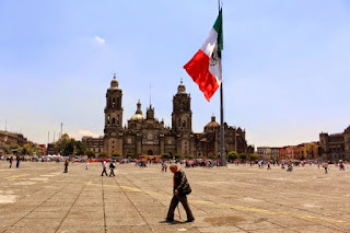
Zócalo
Main Plaza

second largest plaza in the world, 
after Red Square in Moscow.
  • México Barroco | Baroque Art: Representing Divine Ecstasy, Evoking AweIn Mexico, the art of the Baroque epoch (mid 17th to mid 18th centuries) is all around you in Centro and in many of the old churches throughout the city. It is the art of the height of the Spanish Empire, and it realized its most elaborate form in Nueva España. An excellent Wikipedia article on the Baroque helped us see its character as centered on grandeur, lavishness, and drama. We also came to realize the goal of its religious forms was to express holy ecstasy (stepping outside the ordinary world) and evoke awe. With that perspective, we explore the central and quintessential expression of Baroque religious architecture in Mexico City, the Metropolitan Cathedral. There are innumerable other examples in churches around the city.
El Sagrario
The Tabernacle portion of
the Metropolitan Cathedral,
in high Baroque style

IV. Thematically or geographically related pages

  • Mexico's History As Embodied In Mexico City: Lists and links to all posts addressing the many stages in Mexico City's history as they are manifested in the cityscape, from the indigenous reign of the Mexica/Azteca through the Spanish colonial period (1521-1821), and the 19th and 20th centuries, up to the Mexican Revolution (1910-17) and its aftermath. 
Chapultepec Castle,
scene of several significant events
of the 19th century.
  • Mexico City's Original Indigenous Villages and Their Spíritual ConquestContemporary Mexico City is an amalgam. It's core is the Spanish Colonial Centro. It did not significantly expand beyond that until the late 19th century. Then, in the second half of the 20th century, it exploded with rapid urbanization of previous lakebed and rural land. In that relatively recent explosion, it swallowed up ancient indigenous pueblos. These are villages, that, beginning some three thousand five hundred years ago, were established on the shores and islands of the five lakes at the center of the Valley of Anahuac. So Cortés and the Spanish not only had to transform Tenochtitlan, they also had to transform a geographically extensive civilization and culture via the "evangelización de los indios," or "los natuturales", what has been called the Spiritual Conquest. This series of posts explores the churches, neighborhoods and fiestas that continue to embody that encounter and the synthesis of the two civilizations. (This is our current work-in-progress).
Original, 16th century chapel of San Francisco,
in Quadrante (Quarter) of San Francisco,
originally the indigenous village of 
Hueytetitlan, now in Delegación Coyoácan.

  • Centro: El Centro, the Center of Mexico City, actually consists of five colonias, or neighborhoods: Centro Histórico, and East, West, North and South Centro. Spanish colonial palaces and smaller residential and commercial buildings from that period are numerous, but mixed in among them are buildings from the 19th and 20th centuries. Within them, and flowing among them in the streets, is the everyday, timeless activity of selling and buying.
Portable shoeshine stand
in Plaza 
de Santo Domingo
  • Chapúltepec Woods and Paseo de la Reforma: Five kilometers, three miles, southwest of Centro, on what used to be the western shore of Lake Texcoco, sits the ancient, sacred site of el Bosque de Chapúltepec, Chapultepec Woods. It was the first place that the Mexica/Azteca tried to settle down near the end of the 13th century, and later their royal retreat and source of fresh spring water for Tenochtitlan. The Spanish turned it into a park for themselves and continued to depend on its freshwater springs. 
Subsequently, a "castle", actually a palace, was built by a viceroy (ruling representative of the king of Spain) at the top of its landmark hill, an ancient ash cone volcano. After Independence was won from Spain in 1821, it served as the Mexican Military Academy and, in 1847, it was the scene of the last battle in the U.S. invasion of Mexico (aka Mexican-American War). In 1864, Emperor Maximilian I, put in place by Napoleon III of France at the request of Mexican conservative forces, decided to make it his palace. To connect it with the City Center, he had a boulevard built and named after his wife the Belgian Princess Carlotta. After his overthrow by liberal reform forces led by Benito Juárez in 1867. it became Paseo de la Reforma.
Paseo de la Reforma,
seen from Chapultepec Castle
  • Reign of Porfiro Díaz and Neighborhoods of the Early 20th Century: As the 19th century approached its end, Mexico City's well-to-do, who had increased in numbers under the economic policies of Porfirio Díaz (multiple times reelected president and dictator from 1876 to 1911), sought new residences outside the old Spanish Colonial Centro Histórico. They began to develop colonias, planned neighborhoods, to the west, along Paseo de la Reforma boulevard, and to its north and south. Díaz and the well-to-do had a great admiration for French culture. Hence, these colonias have a French flavor. Posts on six of these neighborhoods, with introductions, are listed.
French Second Empire-style homes,
with characteristic mansard roofs.
  • Mexican Revolution: Overview of Its Actors and Chapters: The Mexican Revolution (1910-1917) was a watershed between traditional and modern Mexico. Actually, a series of four civil wars fought between a diverse cast of characters with widely disparate histories and motivations, the war and its turbulent aftermath can be divided into five stages or chapters, each consisting of a number of critical episodes. This Page offers an overview of the war and links to Pages with fuller accounts of the personalities and each chapter of the war and its volatile aftermath.
Monument to the Revolution
  • Mexican Muralists: During the Mexican Revolution, a revolution in Mexican Art was triggered. After the Revolution, it unfolded in a group of buildings in Centro and expanded across the city throughout the 20th century. This page provides links to posts on the sites and their murals—works by the "Big Three": Diego Rivera, José Clemente Orozco, David Alfaro Siqueiros, and their successors, who continue to produce works up to the present.
Mural of Cortés and Malinche,
representing the mixing (mestizaje)
of Spanish and indigenous peoples.
by José Clemente Orozco,
in the museum San Ildefonso.

Friday, May 31, 2019

Original Villages | Fiestas in Pueblo Iztacalco, Part I: Commemorating the Past, Enjoying the Present

Challenge of Finding Fiestas in Pueblo Iztacalco


Delegación/Alcaldía (mayoralty, borough) Iztacalco, the smallest delegación/alcaldía in the city, is no more than fifteen minutes north from our home base in Delegacion/Alcaldía Coyoacán. Immediately southeast of Delegación Cuauhtémoc (Centro Histórico's location)it has major highways and avenues surrounding and crossing it, so it is easy to access. San Matías church, from the 16th century, is the central church of the original pueblo, while each of its seven barrios, Santa Cruz, La Asunción, San Miguel, Los Reyes, San Sebastián Zapotla, San Francisco Xicaltongo and Santiago Atoyac, has its own chapel, so there should be plenty of fiestas.

Yet, we have found it difficult to find fiestas that its barrios are celebrating individually or together as a pueblo in the plaza in front of San Matías. A couple of barrio fiestas we have attended have been so small in attendance and limited in their activities that we haven't been able to find a narrative to present them. We did present the Barrio Santiago Atoyac's Honoring of the Virgin of Guadalupe. It, too, was a small affair, but full of ánimo (spirit, liveliness) and color, providing the elements of a good post. Perhaps, we thought, we just hadn't yet found the major fiesta.

Finally, recently, our luck changed. There were two fiestas in Iztacalco held close together. First, in mid-April was el Viernes de Dolores (Friday of Pain or Sorrows) the Friday before Palm Sunday, which venerates the Virgin Mary for all the sorrows and pain she experienced in the life of her son, Jesus the Christ, ending in His Passion, his torture and crucifixion during Semana Santa (Holy Week).

The second fiesta was in mid-May, the patron saint fiesta for San Matías. We will present that in part II of this series.

From Recalling with Sorrow the Sufferings of the Virgin to Recalling with Pride La Viga Canal


Arriving at the Viernes de Dolores, we do not find the expected focus on the Virgin Mary and her suffering. Normally, it is accompanied by an elaborate and specific set of symbols for her suffering, such as a heart pierced with seven daggers, representing the seven times in her life when she was made aware that her son would die as a sacrifice, or hanging glass globes filled with liquid, representing her tears. Instead, we encounter a celebration of the history of the Royal or (after Independence from Spain) the National Canal, popularly called La Viga (the Beam). The change of focus and the reversal of sentiments is, to say the least, striking, but we realize from past research about the history of Mexico City that there is an underlying connection.


Iztacalco's Transformation from an Island, to a Stop on a Canal


Iztacalco was originally an island or set of islands, among many in the midst of a bay in the southwest corner of Lake Texcoco, south of the great city of the Mexica/Azteca, Tenochtitlan. Its residents made their living by extracting salt from the waters of the lake and selling it in the famous market of Tlatelolco, just north of Tenochtitlan. (The lakes, being totally surrounded by mountains, had no outlet to the sea. Lake Texcoco was the lowest in altitude and therefore received the waters from the four other lakes in the system, thus becoming salty.) Iztacalco means House of Salt in Nahuatl.

The island of Iztacalco
lay near the southeast end 

of the west bay of Lake Texcoco,
about halfway between the Peninsula of Iztapalapa

(lower right corner) 
and the island city of Tenochtitlan.

Sculpture of the Nahuatl glyph for House of Salt
in the Plaza of Iztacalco

In the 17th century, the Spanish decided to drain Lake Texcoco to protect Mexico City (built atop the destroyed Tenochtitlan), from frequent flooding during the summer rainy season. As the lake dropped away, they built the Royal Canal to provide a water route for the transportation of agricultural products from the chinampas (man-made islands) in Lakes Xochimilco and Chalco, in the southern part of the Valley, to the City.

Iztacalco — now no longer an island, but part of the mainland, and no longer with a salt business —  became a major stop along the canal, with a pier for loading products for the city. (See our post: La Viga Canal: Pathway from a Land of Lakes to One of Roadways)

La Viga (former Royal, then National) Canal in 1850.
It is superimposed on a map of Mexico City from 1970.
Iztacalco lies somewhat more than halfway up the canal.

Heavy red line up the center is modern outer-ring expressway.
Thin red line up left side is Calzada de Tlalpan,
the former Mexica cuepotli, causeway,

between Tenochtitlan and the southern end of Lake Texcoco.

Paseo (trip) of Viceroy (1702-1710) Don Francisco Fernandez de la Cueva, Duke of Albuquerque, 
and his wife, Doña Juana de la Cerda, up the Royal Canal in the early 18th century. 
Their barge is in the foreground.

The church of 
San Matías Ixtacalco is in the left background. 
(The pueblo's name was spelled with an 'x' until the 20th century.)
Painted by Pedro Villegas in 1706,
it is the oldest representation of the Canal de la Viga and chinampas (man-made island gardens, on the right).
Wikipedia en español

Church of San Matías today,
little changed in over four hundred years.
How El Viernes de Dolores Became Connected with La Viga Canal: El Paseo de la Viga

In 1785, Viceroy Bernardo de Galvez ordered a promenade built alongside the Royal Canal. When de Galvez died unexpectedly, it was completed under the mandate of the new viceroy, the Second Count of Revillagigedo, who undertook a major renewal of the entire cityscape.

Called el Paseo de la Viga, it ran from south of the Church of San Pablo Nuevo, in what was then the southeast corner of the city, to the Garita (tollhouse) de la Viga (see map above), near Pueblo Santa Anita Zacatlamanco, north of Iztacalco (see island map above). It was approximately one kilometer, a little over half a mile in length, and thirty meters, or nearly a hundred feet, wide. On Sundays, families would take a paseo, stroll, along the western side of the Canal. They could also ride horses or in carriages or travel on the Canal on trajineras (flat-bottomed canoes), just as Mexicans and tourists do today on the canals of Xochimilco.

El Paseo y Garita de la Viga
Lithograph by Casimiro Castro
In the foreground is the embarcadero where people boarded flat-bottomed trajineras.

To the right is the Paseo, filled with pedestrians
and horse-drawn carriages.

From: El Paseo y la Garita de la Viga
By: Manuel Aguirre Botello
MexicoMaxico

It became the tradition to hold a large tianguis (outdoor market) and festival during Semana Santa (Holy Week) at the end of the Paseo in Santa Anita Zacatlamanco. Such Semana Santa holiday markets are still held in various cities in Mexico. There are big ones in Pátzcuaro and Uruapan in Michoacán, where we used to live. We are grateful to Diego Rivera for a wonderful mural of this market/fiesta along the canal, still held in the 1920s.

Viernes de Dolores en el Canal de Santa Ana
Friday of Sorrows on the Santa Ana Canal

Diego Rivera, in the Secretariat of Public Education
Fiesta del Viernes de Dolores
Canal de la Viga
Pueblo Santa Anita.

From Facebook page
Iztacalco Barrio Mágico, Pueblo Bendecido por Dios
@barriomagico.iztacalco
During the 1920s, trucks replaced the need for trajineras to bring produce into the center city, and paved roads eliminated the need for the canal. It fell into disuse but remained in existence until the 1950s. Then, as part of a government urban development plan to create many major avenues for automobiles in the city, the canal was filled in and paved over, becoming the avenue Calzada de la Viga. In place of the canal, it now runs through the center of the original Pueblo Iztacalco, directly in front of the Plaza and the Church of San Matías.

Street sign near the central plaza.

Plaza de Iztacalco, seen from la Calzada de la Viga.
The Church of San Matías sits to the rear, hidden by the 19th-century kiosk
and vendors' tarps.

What we witness today, on el Viernes de Dolores, is a remnant of that former holiday market, moved south from neighboring Santa Anita, and a commemoration of the important place la Viga Canal played in the history of Iztacalco after it was transformed from an island producing salt to a stopping point on that primary commercial pathway of the City. 

Images of La Viga


As we enter the plaza, we see along one side a display of photographs. They are turn
-of-the-19th to 20th-century images of la Viga:

La Viga
The arches structure is a garita, a toll booth

Because the exhibit is outside, the photos are covered with plastic wrap. Hence the wrinkles.


"La Flor Más Bella" de la Viga.
The Most Beautiful Flower" of la Viga.
Here is a link to a wonderful, three-minute slide show of more old photos and paintings of life on and around La Viga from the late 19th century into the early years of the 20th. It includes photos of the fair of Viernes de Dolores and "La Flor Más Bella", presented below in this post. Video thanks to the Facebook page Iztacalco Barrio Mágico.

"La Flor Más Bella", "The Most Beautiful Flower"


The last photo portrays "La Flor Más Bella", "The Most Beautiful Flower" of the canal system. It is a beauty contest sponsored by the flower growers in the chinampas and users of the canal and held each year at Easter time. The contest is still held every Eastertide on the canals of Xochimilco. It celebrates the chinampa-canal system which makes possible the year-round growing of flowers and produce, making it the major source for the flower and vegetable markets all over the Valley, from the major Jamaica indoor market to smaller local formal markets to informal street vendors. (See our post on the Markets of Mexico City)

Now, here in Pueblo Iztacalco, we are presented with its Flor Más Bella. A gentleman in traditional charro cowboy suit with a huge sombrero speaks to the small crowd about the history of la Viga and its importance in the heritage of Iztacalco


Then a pretty young woman and two other females, dressed in indigenous-style dress come forward. 

"La Flor Más Bella" is in the middle. 

La Flor Más Bella and the other two women wear variations of parts of female dress popular among urban women in central and southern Mexico, including Mexico City, Puebla and Cuernavaca, during the 19th and early 20th century known as China poblana (Puebla woman). It mixes elements of various indigenous dress components, such as the huipil, the square-cut blouse with embroidered flowers from Chiapas and Oaxaca, two highly indigenous states. Frida Kahlo, at the encouragement of her husband, Diego Rivera, is the most famous representative of China poblana attire, a modern, urban woman displaying a rural indigenous heritage. It is worn here for a ceremonial occasion. It is hardly ever seen on the streets of Mexico City. Upscale women in Cuernavaca dress in huipil blouses and blue jeans.  

A China poblano dress of Frida Kahlo
Frida Kahlo House Museum.

La Flor Más Bella


Danzón: Dance that is Elegant, Formal and Sexual


After the commemoration of La Viga, the party really begins. Danzón music is played from loudspeakers and several couples of la tercera edad, the third age, i.e., senior citizens, get up from the plaza benches and begin its slow, stylized and sensuous movements. They are definitely "dressed-up" for the occasion, the women in cocktail-style dresses, the men mostly in suits or sports jackets and slacks. Danzón arose in the tropical heat of Cuba, a mixture of Spanish 2/4 contradance rhythm and African syncopation. Many danzón groups exist in towns and cities across Mexico.

Let´s dance!

Wouldn't we love to be able to wear
 an indigo suit?

Or a black fedora with an orange band and a white suit with an orange handkerchief?

We´ll dance until we can no more.


Love all around


Delegación Iztacalco
is the small, dark green area
in the northeast of the City,
just southeast of Delegación Cuauhtémoc,
site of Centro/Tenochtitlan.

Delegación/Alcaldía Iztacalco
with its barrios and colonias.
The center of the barrios forming the original Pueblo Iztacalco 
are marked by green/yellow star.

Blue line passing through the star was the Viga Canal,
now the avenue Calzada de la Viga.

Original Pueblo de Iztacalco
composed of seven original barrios
marked by black boundary line.
(Barrio Santiago has been divided into north [green] and south [yellow] sections.
Pueblo Santa Anita (green area at top) was a separate pueblo.
 Site of plaza and main Church of San Matías, in Barrio Asunción, 
is marked by 
green/blue star.

South to North line up the middle marks the original Canal de la Viga,
now the avenue Calzada de la Viga.

Friday, May 24, 2019

Original Villages: Carnaval in Santa María Aztahuacan

As we wrote in our recently published post, Discovering the Pueblos of Eastern Iztapalapa, we have been intrigued for the past year by a group of originally indigenous pueblos we virtually stumbled across in the eastern portion of that large delegación/alacldía (mayoralty, borough). There are five in the group:
Santa María Aztahuacan;
San Sebastián Tecoloxtitla;
Santa Martha Acatitla; 
Santa Cruz Meyehualco and
Santiago Acahualtepec.
. 
In researching their history, we learned that Santa María Aztahuacan has been a village almost continuously for some 3,000 years, making it one of the oldest in the Valley of Mexico. San Sebastián Tecoloxtitla and Santa Martha Acatitla go back about 2,000 years. We made it first to Santa Martha Acatitla's Carnaval a year ago. It was so grand, colorful and full of ánimo (spirit) that it motivated us all the more to want to visit its sister pueblos. We got to San Sebastián Tecoloxtitla for its patron saint fiesta this past January and also saw a parade of charros, Spanish-style, fancy dressed cowboys. 

Then, this April, we hit the jackpot. We learned that three of the pueblos, Santa María Aztahuacan; San Sebastián Tecoloxtitla and Santa Martha Acatitla were joining together to hold un gran cierre, a grand closing or finale to the Carnaval season in April. We just had to attend. It was to start in Santa María Aztahuacan and march on to San Sebastián Tecoloxtitla and Santa Martha Acatitla. There was no way we could follow it that whole way, but we could witness its start. So on the appointed Sunday morning, we called a taxi and headed off along the Calzada Ermita-Iztapalapa boulevard to the far side of the delegación. Now somewhat familiar with these pueblos, we quite easily found the parade participants gathering on Avenida México in Santa María Aztahuacan. 

Carnaval, in general, is famous for being a grand parade, lavish, full of people in diverse costumes, an almost over-the-top extravaganza. This one fulfilled all such expectations. When we arrive, we find huge carros alegóricos, motorized floats, decorated with all kinds of themes ready to carry elegantly dressed princesses representing the various pueblos and their comparsas (parade marching troupes). 

Quetzalcoatl, the Feathered Serpent,
a major indigenous god.

The comparsas consist of two types. Several are composed of Spanish charro cowboys in their elegantly embroidered suits. 


The others are comparsas de disfraces, people in disguises of all kinds (think Halloween).  

A carro de disfraz, Alice in Wonderland,
with the Red Queen, the Mad Hatter, the Cheshire Cat, the White Rabbit and Alice!

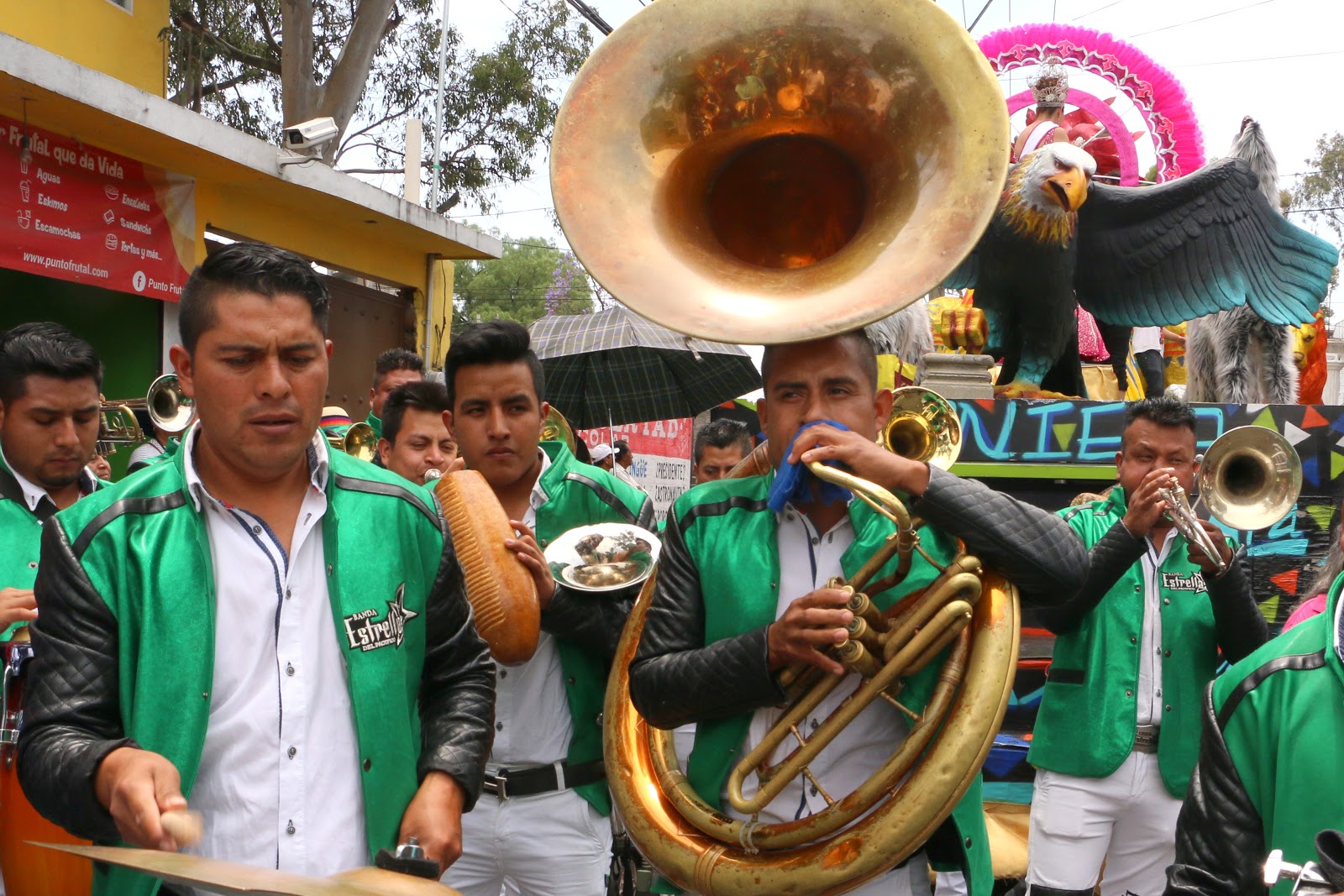
And, of course, for each comparsa there is a brass banda to set the tempo and rhythm. 

Una banda

While all the comparsas parade in an orderly manner, each in its place in the line (while there is some beer drinking among spectators, there is no drunken revelry), the sheer number and variety are almost overwhelming to our senses. But then, that's what Carnaval is supposed to be — taking us to the limits of stimulation. We hope the photos that follow convey that. 

The "Pheasant" charros of Santa Martha Acatitla


.
The designs, embroidered in gold thread on the backs of the charro suits,
are a virtual art gallery, here mostly of mythical themes.
From top left, clockwise: a pheasant, Hercules slaying the Nemean lion (the first of his twelve labors), a royal crest with griffins, a cobra, a fairy creature, a nymph, a geisha, two centaurs battle.


A float....
...and its princess, Vanessa.

Another float...

...and its princess.

Disfraces, disguises
Los Morenos, the dark-skinned ones.
     

We particularly like this one
for its ingenuity of theme and execution,
and its timeliness:
The Donald carries a Mexican on his back.
A classic of Mexican political cartooning.


Dragon float
Yaneli ("the 1st) is the name of the princess.

        
Princess Yaneli
with a Chinese theme.

The Sparrow Hawks,
another comparsa of charros

Life and Death together
is a common theme in the Mexican imaginario, world view.
Charro masks are often of skulls (top, second from left), or half skull-half flesh.
Death brings even los de arriba (those above) down;
making them equal to los de abajo (those below).

Another Mexican joining of opposites is portrayed in bottom row, second photo from right:
The left half of the face is a blue-eyed Spanish conquistador;
the right half is that of an Azteca warrior.
Here a hooked chain has been run through the nose and mouth,
sealing the lips of both. 

Float with its princess

Charros, The Eagles

Azteca Sun Stone,
Portraying the Five Suns or Worlds created by the gods.
Four attempts 
(symbols in rectangles around the center)
to create a world that worshiped them failed.

The Fifth Sun, whose Sun God, Tonatiuh is at the center,
was the world of the Mexica/Azteca.


Matador and Bull Float
(We think this is the most amazingly executed float, with thousands of mirrors and

the dynamically sculptured charging bull.)

Karime is the name of the princess.


Princess-in-waiting

Disguises of the Barrio

A rather more gruesome group

An American Bald Eagle?
The Mexican Eagle is the Golden Eagle.

Princess Daniela
What "SGM" stands for we don't know.
Our guess is,
"Señorita de la Gran Marcha"

More charros

Even the underside of this sombrero is elaborately embroidered.

More dragons, a popular theme.
(The man with the pole is there to raise overhead electrical wires that could catch on the float.)


The float is a stunner!
So is Princess Thayli!
Although it is a bit anomalous: a Conestoga wagon pulled by a buffalo,
with a Native North American (not an Azteca) at the rear.

And, of course, some onlookers.
The bib on the baby (far right, below) says,
"I am a reduced and authentic copy of papa."


So that´s Carnaval in Iztapalapa, Mexico City. Hope you enjoyed it. 


Iztapalapa is the large, medium green delegación on the mid-east side of the city.

Pueblos and Colonias of Delegación/Alcaldía Iztapalapa

Pueblo Santa Maria Aztahuacan is orange area to upper right of green/yellow star.
Pueblo Santa Martha Acatitla is large, dark blue area to the northeast.
Pueblo San Sebastián Tecoloxtitla is bright green area west of Santa Martha.

Black line is the Calzada Ermita-Iztapalapa