Prelude | The Importance of Delegación Gustavo A. Madero in the History of Mexico, and the Challenge In Getting There
As we have mentioned various times in our accounts of our Ambles around Mexico City, one of our goals is to get to every one of it
sixteen delegations (boroughs). We have actually achieved that goal and been to all sixteen, including at least one fiesta in each one. Thee
delegaciones most difficult to reach from our apartment in Coyoacán, which is in the geographic center of the city. are those around the periphery of Mexico City. We continue to seek to visit as many as possible of what were the original indigenous pueblos in each of these
delegaciones.
MCA Note: For the record, in 2016, the delegaciones were renamed alcaldías, mayoralities. This was one of the last steps in a political process that began in the 1990s for changing what had been the Federal District — el 'Distrito Federal', informally referred to as 'el De Efe', governed directly by the federal government — to official governmental status as Mexico City. As such, its government is now elected by its residents, and it has autonomy from the federal government with regard to its internal governance that is virtually equal to that of the nation's thirty-one states.
Mexico City's alcaldías enjoy a status similar to municipalities, the governmental subdivisions of states, and their elected heads are now called alcaldes or alcaldesas, mayors. We began Mexico City Ambles in February of 2015, a year before the change of names, so we have used the term delegación(es). Since that name continues to be used by 'chilangos' (Mexico City residents), other than officials, we will also continue to use it. See our page: How Mexico City Grew from an Island to a Metropolis.
Delegación Gustavo A. Madero: Where It Is, and How It Got Its Name
One such
delegacíón that we have barely
explored is
Gustavo A. Madero. GAM — as it is commonly referred to
— is the city's northernmost
delegación, forming the "
stem" of the city's pear shape. This "
stem", which seems an odd extension of the city when seen on maps, is a consequence of its being a narrow valley bounded on both sides by the
Sierra de Guadalupe mountains. On the other side of these mountains is the State of Mexico.
The delegación is named after the brother of Francisco Madero, briefly president (1911-13) after the first stage (1910-11) of the Mexican Revolution, in which the dictator, Porfirio Díaz (president from 1876 to 1911) was overthrown. Gustavo was a close ally of his brother in initiating the Revolution and forming the new government. Like his brother, he was assassinated during the overthrow of the Madero government by Gen. Victorino Huerta (with the support of the U.S. Ambassador Henry Wilson) during the Ten Tragic Days of February 1913).
 |
Delegación Gustavo A Madero (pink)
sits at the northern end of Mexico City.
Our home is in the north-center of Delegación Coyoacán
(the purple one in the middle)
|
A First Glimpse at the Importance of the Delegación in Mexican History
We have been to GAM once before. It was in 2016, when, in our search to come to know and, hopefully, understand the multiple historical forces that have made Mexico City the unique city it is, it dawned on us that it was essential that we needed to return to take a closer look at its beginnings. We needed to investigate at how not only
Tenochtitlán but all the other cities and villages around Lake
Texcoco that now lie within the City were transformed, after their military conquest by Hernán Cortés and his Spanish soldiers and indigenous allies in 1521, from being indigenous to being incorporated into Spanish rule and the Catholic faith and culture.
We have written about how Cortés called upon the young King Carlos to send missionaries to convert his new subjects, and the King and the Pope chose the
Franciscans for the task. Their arrival in
Nueva España began the process that historians have called the
Spiritual Conquest. The Franciscans, consciously or intuitively, realized they could not force Catholicism on the people, but needed to find elements in indigenous beliefs and rituals that could be melded into Catholic religious practice as a means of transitioning the people from the one to the other.
Thus, they initiated a process of syncretization of indigenous culture and religion with Spanish Catholicism and culture, a process that took decades and produced the uniquely Mexican (and subsequently across all the southern part of the Americas, a
Latino/a) Catholic culture. (See our page:
Mexico Traditional Popular Religion).
We soon realized that our quest for the remaining manifestations of this syncretization process in Mexico City had to begin with a visit to the
Basilica of Our Lady of Guadalupe in
Delegación Gustavo A. Madero, since it was on this site that the quintessential manifestation of the merger of indigenous and Spanish culture took place.
According to Roman Catholic belief, here at the base of a hill near a village named
Tepeyac (or
Tepeyacac) in December of 1531, the Virgin Mary, in the form of a
morena (brown-skinned),
Nahuatl-speaking, hence indigenous, young woman appeared to the indigenous peasant, Juan Diego. Over a series of days,
la morena identified herself as the Virgin Mother of Jesus Christ, the Incarnate Son of God, and she informed the recently baptized peasant that she had chosen him to tell the Bishop of Mexico that she had chosen the people of this previously pagan land as Her own special people, to receive Her special care. She was to be called Our Lady of Guadalupe.
The Bishop of Mexico (its first), and a Franciscan, after seeing Her image imprinted on the inside of Juan Diego's cloak, along with a cascade of fresh roses that fell from the opened cloak, acknowledged Her as a true manifestation of the Virgin Mother and fulfilled her directive that a chapel be built for her at the site where she had appeared. Over the years, she became known as the "Mother of Mexico" and the chapel went through several replacements, becoming the modern Basilica and complex of churches it is today. The Virgin of Guadalupe is the core embodiment of the syncretism of the two cultures and hence, the obvious place to start our search for the remaining manifestations of that merger is at the Basilica bearing her name.
Our Challenge in Getting to Gustavo A. Madero
It was a challenge to get to the Basilica via
the Metro, requiring two changes of lines and at least an hour of travel time. As satisfying and enlightening as our first visit was, we still rather dreaded visiting
Delegación Gustavo A. Madero. However, one day, fairly recently, we were riding somewhere with a taxi driver who said he lived in GAM. We told him of our desire to get back there to visit some of its original
pueblos, but how difficult it was via the Metro. He replied, "By taxi, it's easy. You just take the Inner Ring Road. GAM is just the other side of the airport."
Having been to and from the airport many times, we knew it's an easy, comfortable half-hour or so ride via expressway — called
Rio Churubusco in our area, it's only a few blocks from our apartment. So, GAM was within our reach! Then we just had to wait for an announcement on our beloved
Fiesta Mágicas Facebook page of a fiesta in one of GAM's original
pueblos for an opportunity to go.
Pueblo San Bartolo Atepehuacan
In early August, an announcement appeared for
la Fiesta de San Bartolo in
Pueblo San Bartolo Atepehuacan, in GAM
. Checking our
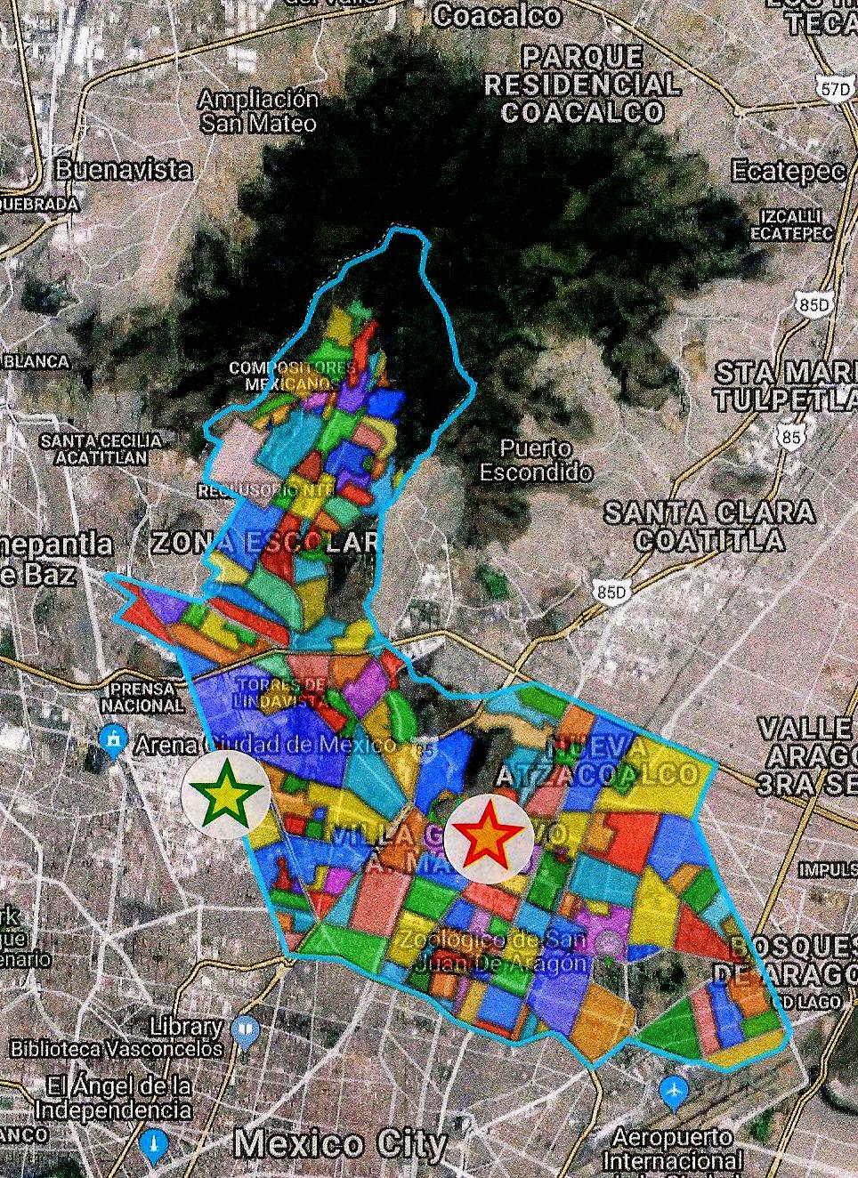
map source "Delegaciones and their Colonias and Barrios", we found
San Bartolo Atepehuacan was near the intersection of two main avenues, easily accessible from the Ring Road. So we made plans to go.
Where San Bartolo Atepehuacan Is
 |
Delegación Gustavo A Madero
With its 177 Pueblos and Colonias (many are very tiny).
Pueblo San Bartolo Atepehuacan is tan area just to right of green/yellow star.
The Basilica of Our Lady of Guadalupe is about 1.5 miles east,
left of red/orange star.
(It sits beneath the purple letter "G" of the name Villa Gustavo A Madero)
The dark green area to the north are the Sierra de Guadalupe mountains.
Mexico City International Airport is southeast of GAM
(in Delegación Venustiano Carranza, named after the winner
of the Mexican Revolution and subsequent president).
Blue line marking the southwestern border of GAM
follows the Inner Ring Road from the airport west. |
Where the Original Pueblo Atepehuacan Was
As our readers know, we always want to try to locate where the present-day pueblos, now immersed in the metropolis, were originally located in the Valley called Anahuac by its Nahuatl-speaking residents prior to the arrival of the Spanish in 1519. From its current location, we know that the original pueblo of Atepehuacan was not far west of Tepeyac, the current site of the Basilica of Our Lady of Guadalupe. We assumed San Bartolo Atepehuacan was, like Tepeyac, along the north shore of the bay that formed the southwest part of Lake Texcoco. They would have been, we thought, about a half-hour walk apart.
 |
The Valley of Anáhuac, renamed Mexico by the Spanish,
as it existed at the time of their arrival in 1519.
Tepeyac (here spelled Tepeyacac)
was on the west side of Lake Texcoco,
at the point of a peninsula formed by the Sierra de Guadalupe,
which created a bay in the southwest portion of Lake Texcoco.
Atepehuacan lay west and slightly north of Tepeyac(ac). |
We were in for a surprise. During the very process of writing this post, on the Facebook page of another original pueblo,
Pueblo Santa Cruz Atoyac, in
Delegación Benito Juárez, appeared exactly what we needed:
a detailed map of just the bay that formed the southwest section of Lake Texcoco, locating and naming virtually every pueblo that existed around it and on its islands before the Spanish arrived.
 |
Southwest bay of Lake Texcoco,
with Tenochtitlán of the Mexica in the center.
It shows all the altepetls (city-states) and
most of the subsidiary villages
subordinated to the Mexica of Tenochtitlán
after they defeated Azcapotzalco in 1428
(on west shore of the lake, upper left) .
The Mexica then built the causeways
to make access to their dominion easier.
Atepehuacan turns out to have been an island,
in the middle of the bay's northern end!
The Mexica connected it via a short causeway,
to a long one from Tenochtitlán
north to the altepetl of Tenayuca.
Atoyac is located on the southwest shore of the bay.
From the magazine Arqueología Mexicana.
The title says it portrays the Basin (Valley) of Mexico, but it does not.
Our first map shows the entire Basin/Valley.
|
History of Pueblo San Bartolo Atepehuacan
Prehistoric Period
Amazingly, the island that became known as Atepehuacan is the site of the discovery of one of the earliest evidence of human presence in the Valley of Mexico. In 1957, the fossilized bones of a mammoth were found, together with stone tools, likely used to butcher the animal. Carbon dating of these remains indicate the presence of human beings 9,000 years ago! Many other mammoth skeletons have been found in the Valley, as well as human skeletons that are also at least 9,000 years old.
In the second millennium BCE, some 3,500 years ago, the first agricultural settlements appeared in the area around the north end of the bay of Lake
Texcoco. It has been labeled the
Tlatilco culture, named for the present-day town where remains of a large village were found in the State of Mexico, just west of the present
Delegación Azcapotzaclo, which is west of GAM (see map of delegaciones above). Remarkably, villages of the same culture also lay within what is now
Delegación Gustavo A. Madero. They are still there, the
pueblos of
Ticoman and Zacatenco.
Era of the Nahua Altepetls (City-States) and the Rise of the Mexica of Tenochtitlan
When the village of
Atepehuacan was founded isn't known
. Its name is
Nahuatl, meaning "the hill where the water comes from". To what water this was referring we don't know. Perhaps there were springs releasing water carried underground from the mountains just to the north. Likely it was founded, or became a
Nahua village (possibly replacing earlier residents) sometime around the beginning of the second millennium CE, when
Nahua tribes began to enter the valley they named
Anáhuac. It was already there when the
Mexica arrived in the mid-1220s. The residents made their living by drying lake water to obtain salt, which they then traded with other villages.
 |
Reproduction of the original glyph of the village's name:
Here, in Spanish, "On The Hill of the Water"
Plaque at the entrance to the atrio
of the Church of San Bartolo Atepehuacan. |
Across the bay, to the southwest of the island, was the major
altepetl (city-state) of
Azcapotzalco, whose residents were
Tepaneca, a
Nahuatl-speaking people. Some historical accounts from the 17th century, written by indigenous for the Spanish, say
Azcapotzalco was settled in the 10th century CE, about three hundred years before the arrival of the
Mexica in the Valley of
Anáhuac.
By the time the
Mexica arrived in the Valley, around 1220 CE,
Azcapotzalco dominated the west side of Lake
Texcoco. Whether
Atepehuacan and
Tepeyac were
Tepeneca villages under its dominion we don't know, but it seems highly probable. When the
Mexica founded
Tenochtitlán in 1325, it was on islands under
Azcapotzalco's dominion, so the new
Mexica city was also its subject.
In 1337 a dissident group of
Mexica broke with the rulers of
Tenochtitlán and founded their own
altepetl,
Tlatelolco, on an island just to the north. In 1428, the
Mexica of
Tenochtitlán, with the support of
Tlateloloco, Tlacopan and
Texcoco defeated
Azcapotzalco. It is likely that
Tlatelolco took control of the islands to its north, including
Atepehuacan, at that time, because even though
Tenochtitlán forced
Tlateloloco to submit to its rule in 1473, the islands were under
Tlatelolco's rule when the Spanish arrived in 1519.
Life in Nueva España, Under Spanish Rule
After the Conquest by the Spanish in 1521, in keeping with Cortés's
strategy of maintaining indigenous political structures, but under Spanish control,
Atepehuacan was kept within the jurisdiction of
Tlatelolco, which was renamed
Santiago Tlatelolco. The Franciscans came there early on and built a large
Convento de Santiago Tlatelolco. In 1535, they opened the
Colegio de Santa Cruz (Holy Cross), a residential school to educate sons of the indigenous ruling class in the Spanish language, Roman Catholic beliefs and Spanish culture, like the one they had created at
San José de los Naturales, their main convent in the former center of
Tenochtitlán, then
La Ciudad de México.
From
Santiago Tlateloloco, via the
Mexica causeway to
Tenayuca (see map above),
Fray Pedro de Gante, one of the first three Franciscans to arrive in
Nueva España in 1523
, and Fray Martín de Valencia and Fray Toribio de Benavente (known as Motolinia) — two of the so-called "Twelve Apostles" who arrived in the second group in 1524 — came to the
Atepehuacan to begin the conversion of its residents.
The current church of
San Bartolomé Apóstol was erected by the Franciscans sometime between the latter part of the 16th and the early years of the 17th centuries.
 |
Map of the Quarter of Santiago Tlatilulco (Tlatelolco)
drawn by José Antonio Alzate,
for the Ecclesiastical Atlas of the Archbishopric of Mexico, 1767.
San Bartolomé (far right) was one of the pueblos under the oversight of Santiago Tlatelolco.
The map indicates it was 1 (Spanish) league from Santiago Tlatelolco, equal to 2.6 miles,
which is close to its actual distance of 3 miles.
(The map's orientations are off by 90 degrees.
San Bartolomé is north (Norte) of Santiago Tlatelolco, not west [Poniente] |
 |
| Church of San Bartolomé Atepehuacan, today. |
From an Island in a Lake to a Village Surrounded by Spanish Haciendas
Beginning in the 17th century, the Spanish undertook the monumental task of
draining Lake Texcoco and Lakes Xaltocan and Zumpagno to the north to try to prevent flooding of the city during the summer rainy seasons. At the northwest end of the Valley, they dug a tunnel through the mountains, using it to connect the
Cuautitlan River (see map above of Valley of Mexico), to the Tula River, which is part of the Gulf of Mexico watershed. Then via the tunnel, they reversed the flow of the
Cuautitlan River through the tunnel, draining the lakes.
As Lake Texcoco dried up, the river named by the Spanish
Río de los Remedios (River of the Remedies), which had drained into the western side of the bay (
on the map of the Bay, note the river flowing into the bay north of Azcapotzalco) was extended as a canal across the former bay, past
Atepehuacan and connected to the diminishing remains of Lake Texcoco and thus to the main drainage system running north to the tunnel.
 |
Lake Texcoco by Mid-19th Century
The draining of the lakes occurred slowly.
San Bartolo Atepehuan is not named here, but lay far west of the lake,
north of Mexico City, just north of Santa Magdalena
and west of San Miguel Guadalupe (site of the Basilica).
El Río de los Remedios now flowed past San Bartolo Atepehuacan. |
As what had been water around Atepehuacan — like that around all the many other islands in the lake — turned into dry land, it became available for human use. Under Spanish law, all such land belonged to the Crown, which could then make encomiendas, land grants, to persons of its choice. Such grants went to Spanish settlers (known as peninsulares, if they came from the Iberian Peninsula) or criollos (children of pure Spanish ancestry born in New Spain). They established haciendas, large estates to grow crops or raise cattle.
The newly exposed land around
Atepehuacan was distributed by a number of royal grants, such that
Atepehuacan became totally surrounded by
haciendas. As the
pueblo's residents could no longer make a living by producing salt, they had no choice but to work on the
haciendas. This way of life was to remain the same for the rest of Spanish rule, which ended in 1821.
The
haciendas surrounding
Atepehuacan continued to exist even after Mexico gained its independence, which was actually won by
consevative criollo leaders under Agustín Iturbide, and the residents of the
pueblo continued to make their living on the
haciendas.
Mexican Revolution Brings the Pueblo Some Land of Its Own
One of the motives of some forces joining in the
Mexican Revolution (1910-17) — particularly those of Emiliano Zapata from the south and Pancho Villa from the north — was to regain land taken from indigenous peoples and granted to the Spanish for
haciendas.
The Constitution of 1917 — written to try to create a government agreeable, on the one side, to Zapata and Villa, and on the other side, to the forces of Venustiano Carranza, a conservative, wealthy ranch owner — did establish the government's right to expropriate such lands and give them as
ejidos, communally-owned land, to indigenous and
mestizo (mixed indigenous and Spanish) villages. However, Carranza refused to accept the Constitution and war re-erupted between his forces and those of Villa and Zapata.
Under the generalship of Álvaro Obregón, the
Carranza forces defeated those of Villa and Zapata and Carranza became the new president of Mexico. He did not implement any of the expropriation of lands. In 1920, when the Constitution called for election of a new president, Carranza chose a conservative ally as his candidate.
Obregón, believing he should be the next president, gathered former troops of the Revolution and drove Carranza from Mexico City. Carranza was then assassinated while fleeing towards Veracruz, trying to leave the country. Obregón became president (1920 to 1924).
All of this resulted in a significant change for the residents of
Atepehuacan. On May 17, 1923, President Obregón, who was supportive of the demands for expropriation of lands, granted
ejido land to the town. Obregon granted an area of 150 hectares (370 acres) to the pueblo of
Atepehuacan, evidently expropriating it from some of the surrounding
haciendas. Nevertheless, the Spanish-owned
haciendas continued to exist on all sides, and the residents of
Atepehuacan continued to work on them.
 |
"Land and Justice" | Cry of the Zapatistas
Photo: Men of Atepehucan, in front of the Church,
at the time the ejido land was granted to them in the 1920s, |
During the time that Atepehuacan had the ejido land, about one hundred families, totaling about five hundred people, lived in the pueblo. They used the land to grow corn, beans and other crops to feed themselves and alfalfa to feed their cows. In the southern part, a lagoon, fed by water from the Rio de los Remedios canal, provided water.
Life in
San Bartolo Atepehuacan remained pretty much the same as it had been for centuries.
Centuries-long Rural Life Is Overrun By Urban Modernity
All this began to drastically and suddenly change in 1945, when the government of the Federal District (an extension of the federal government) expropriated 114 hectares (282 acres) of the
ejido land, saying it was to be used to create an industrial zone that would provide jobs for the community, but instead, it was used for housing. Many new people moved in around the old
pueblo. In the process, many paved avenues and streets were created crossing and surrounding the
pueblo and urbanizing the entire area, including the remaining
hacienda land, which was sold off by its owners.
Memories collected a few years ago from senior residents of
Atepehuacan — people who were born in the late 1920s into the 1930s — recount this radical transformation. They describe with nostalgia a childhood of living in a rural
pueblo, helping parents work their plots in the
ejido land, playing with friends, knowing everyone in the
pueblo. The streets were of dirt, there was no electricity, piped water or sewage system. An elementary school education was provided by the government in a rented house. Then, beginning with the expropriation of much of the
ejido land in 1945, that world, which had existed for centuries, rapidly began to undergo change, totally disappearing into the engulfing city.
A Core That Survived Everything
Nevertherless, one place has remained constant throughout all of the
pueblo's history, that is, from the arrival of the Franciscans in the early 16th century until today. It is the Church of
San Bartolomé. But that, too, came very close to disappearing by the mid-20th century. A strong current in the Mexican Revolution was directed at reducing significantly, if not eliminating, the presence and power of the Catholic Church in Mexican society.
The Constitution of 1917 declared church property to be the property of the State. The amount of property used for religious purposes and the number of clergy were both limited. The State could use church property for other, secular uses. Clergy lost all political rights, and their presence, as well as religious rituals, were limited to the interior of churches. There were to be no fiestas or processions of the saints through the streets.
However, these restrictions were not embodied in specific laws and, hence, not enforced until the presidency of
Plutarco Calles (1924 to 28), a former general in the Revolution who was fervently anti-Catholic. He had laws passed by the Congress to enforce the limits set in the Constitution. Church property was confiscated. Many clergy were forced to leave the country. Over time, these restrictions were lifted in the face of strong, even violent opposition by faithful Catholics in the
Cristero War (1926-29), but the loss of church power, wealth and presence had its effects on the church of
San Bartolomé Atepehuacan.
San Bartolomé was left without a priest and virtually abandoned. Parishioners went to the parish church attached to the Basilica or to other parish churches in the area for religious services, for masses and for all the archetypical rituals marking the life cycle: weddings, baptisms, first communions, funerals. Although the community continued to support a sacristan, a sexton or custodian, to maintain the building, it increasingly fell into disrepair, to the point of its roof nearing collapse and weeds growing inside in the 1950s.
 |
San Bartolomé Church in the 1930's
Photo from the archives of the National Institute of Anthropology and History, INAH |
At that point, some residents formed a committee to undertake getting the building restored and to petition the Bishop of Mexico City for a priest. Both of these goals were accomplished, and with further repairs and a full-time clergy since the 1960s, the church has been restored to its present, well maintained state and active religious life.
Note: This history of the pueblo is our translated adaptation of parts of a monograph "El Pueblo de San Bartolo Atepehuacan: As Remembered by Its Senior Citizens", a collection of oral histories. The recounting of the rescue of the church comes from "The History of San Bartolo Atepehuacan" as narrated by Sra. Conchita Islas.
The photographs from the early 20th century and the map from the Ecclesiastical Atlas of the Archbishopric of Mexico of 1767, together with other information were generously providcd by Sr. Nestor Rangel Hernández, who maintains the Facebook page of Pueblo San Bartolo Atepehuacan Xipe Tótec and works with other community members to collect and preserve documentation of the pueblo´s history. We met him at the pueblo's patron saint fiesta.
Fiesta Patronal de Pueblo San Bartolo Atepehuacan
San Bartolo, (or
San Bartolomé, St. Bartholomew) was one of Jesus' lesser known disciples. He is little mentioned in the Gospels. Catholic legend says he preached in Asia and was martyred there. His feast day is August 24. So on the Sunday morning following the 24th, we call our faithful taxi stand and ten minutes later one of our regular drivers, who has transported us to many fiestas, arrives and we are on our way.
There is little traffic on the Inner-Ring expressway and in twenty minutes we are passing the airport and following GAM's southern border. In another ten minutes or so, we exit onto the
Eje Central, the Central Axis Road, that leads to the corner of
Pueblo San Bartolo Atepehuacan. Across the street, we spot the ever-sure sign of a fiesta,
puestos (stands) selling food, and
juegos mecánicos (carnival rides) in a side street. Thanking and paying our driver, we get out, cross the wide avenue and enter the typically narrow
calleja of a
pueblo.
The announcement of fiesta activities says that a procession of
San Bartolomé through the streets of the
pueblo had begun earlier in the morning and was due to return to the church at noon, when a mass would be celebrated to honor
San Bartolomé. However many people may have gone on the procession, we find many people in the street in front of the church. The street is covered with a large tarp, to protect them from both sun and rain (August is the middle of the rainy season).
Kermes, a Communal Meal
Around the edges are tables with people providing all kinds of typical Mexican food. Underneath are long tables lined with people sitting and enjoying a meal and the communal spirit of the day. It is a
kermes, a communal meal that is a typical part of a
pueblo or parish fiesta. Traditionally, they were paid for by the
mayordomo, the chief caretaker of the fiesta or by members of the
mayordomia, a committee. Nowadays, they are often supported, as are other fiesta costs, by collections taken in the community over a period of time before the fiesta. Here, the diners are paying for the food. We assume those providing the meals will donate some part of their revenue to the church.
 |
A parish member makes corn tortillas, which are baked on a flat comal, metal griddle,
heated by gas from a small tank.
The cooked tortillas are filled with various ingredients: shredded meat, onions, bean paste.
Tortillas, the very foundation of Mexican food for millenia,
used to be patted into shape by hand and baked on a stone comal over charcoal.
This woman is using a metal press. |
 |
| Kermes, with numerous providers of food. |
The Church of San Bartolomé
As there is no other activity at this point, we go into the
atrio (atrium) of the church to explore this historic building, the revitalized physical and spiritual center of the
pueblo.
 |
Bouquets of flowers adorn the arch of the atrio entrance.
There isn't the usual floral portada arch over the entrance of the church,
but these bouquets are gorgeous. |
In the
atrio, a series of panels have been set up to display art work by children of the
pueblo, portraying the church. Two of them, in particular, catch our eye.
 |
Church of San Bartolomé
Drawing and water color by Ximena Cabrera Rosas, age 10.
She clearly has artistic ability and a meticulous style! |
 |
Church of San Bartolomé.
in a more impressionistic and colorfully Mexican style.
The artist's name, unfortunately, does not appear. |
 |
The interior is small, spare, Franciscan in its simplicity, but flower-filled for the fiesta.
San Bartolomé stands behind the altar. |
Leaving the church and
atrio and walking around to the north side, we discover a now-rare church
panteón, cemetery, enclosed behind adobe walls. In Catholic tradition, the Faithful were buried in sanctified ground, in the
atrio of the church or in the
panteón along side it.
Many church cemeteries were eliminated during the
Reform Period (1857-72), when liberals, under the leadership of Benito Juárez, sought to limit church property, wealth and power. The reform government also required that, for health reasons, all burials be in cemeteries outside the then limits of the Municipality of Mexico City (essentially what is now
Colonia Centro). Restrictions imposed after the Revolution led to a further reduction of church
panteones. This is only the third we have seen beside a Mexico City Church.
 |
| Traditional Mexican Catholic panteón. |
North of the
panteón wall, (to the left) we find a semi-circular park, evidently a remnant of a circular plaza that once surrounded the church.
 |
A shaded, quiet retreat
in what is now an otherwise urban neighborhood. |
Procession Arrives and Mass Begins
At this point we hear the sound of
cohetes, rocket-style firecrackers, and a
banda, both standard announcements of an approaching procession. So we hurry out to the street in front of the church.
 |
San Bartolomé, in demandita form (i.e. in a small size and therefore portable)
surrounded with fresh roses, returns to the church.
The procession, like the image of the saint, has been a small one.
Only a few people have accompanied San Bartolomé through the streets of the pueblo.
There are no saints or banners from other pueblos, which usually visit
and particiapte in the fiesta of neighboring pueblos.
Perhaps it is because Atepehuacan was originally an island,
so there are no other, adjacent orginal pueblos. |
To our surprise, the procession does not enter the church atrio, but another enclosed patio across the street. Following it, we find it is the atrio to a modern and very simple, utilitarian, but much larger chapel, big enough to hold a larger congregation.
 |
Modern chapel begins to fill for the mass celebrating
San Batolomé's feast day. |
El Pueblo, The People
As the preparations for mass begin, we return to the
kermes in the street. Now we, too, are hungry. We look around at the options offered and are attracted to the stand of a young couple barbecuing pieces of pork on wooden skewers over a charcoal grill. They look and smell delicious, so we buy one and, taking a supply of paper napkins, as it will be a messy meal, we walk back around to the north side of the church to sit on a bench in the shade of the park to enjoy the food and rest awhile.
When we finish the barbecue, fully satisfied, we return to the
kermes, which is clearly the main communal event of this fiesta for
San Bartolo. It is a great opportunity to take
retratos (portraits) of the people of this
pueblo. Such portraits are one of our most favorite photographic subjects. The faces of ordinary. everyday Mexicans,
el pueblo, are almost always full of character, of the living of life, of their
ánimo, their spirit.
 |
| The parish priest with members of the fiesta organizing committee. |
  |
Sr. Ricardo Montero (left)
introduced himself to us and
offered to answer any of our questions.
He also showed us the tile glyph of
Atepehuacan,
hidden behind a poster at the atrio entrance.
We would never have seen it without his help, and
we used it (above) in our introduction to the pueblo.
Sr. Nestor Rangel Hernández (right)
maintains the pueblo's
Facebook page and has provided us with much of the
written and photographic history
of San Bartolo Atepehuacan Xipe Tótec*
(Note: Xipe Totec ("Our Lord the Flayed One") was a Nahua deity of life, death and rebirth;
also of agriculture, vegetation, the east (where the sun rises, giving birth to each newday),
disease, spring and liberation.
He flayed himself to give food to humanity,
symbolic of the way maize (corn) seeds lose their outer layer before germination
and of snakes shedding their skin. [Wikipedia]
To us, Xipe Totec's symbolic functions seem close to those of Jesus the Christ,
especially in His Passion, Death and Resurrection,
which are central to Mexican Catholic symbolism and belief. |
The Place of San Bartolo Atepehuacan in the History and Life of Mexico City, and of Mexico as a People
The Fiesta of
San Bartolomé of
Pueblo Atepehuacan was modest:
There was no floral portada over the church entrance, no big procession, no visiting pueblos, no conchero or chinelo dancers.
Beside the mass in a most modest of modern chapels, the big event was the
kermes, the communal meal. But we realize the story that we have come to discern in attending the
pueblo's fiesta, meeting some of its people and researching its history is one worth sharing. It is the story of how
San Bartolo Atepehuacan has managed to survive and maintain a continuity of its identity as a
pueblo, a community of people with ancient roots, despite multiple drastic changes which could have been traumatic and resulted in its disappearance.
It began as an island community whose residents supported themselves by producing salt. The Spanish turned it into a piece of the mainland and the people into the work force for Spanish
haciendas. After a brief twenty-year period of having some
ejido, land of its own, the land was taken away and the
pueblo was then rapidly all but overrun by the modern city. Despite all of that, there remains a community of people, a
pueblo, that still comes together to mark and celebrate the feast day of its patron saint and who, thereby, retain a sense, an experience of their ancient communal identity.
That is the story of
Pueblo San Bartolo Atepehuacan, and of many other of the still-surviving
pueblos of Mexico City, and of all of Mexico. We think that is quite a miracle in, and of, itself.