Showing posts with label Mexico City archeological sites. Show all posts

Friday, July 26, 2019

Tenayuca and Acatitlán, State of Mexico | Remnants of Indigenous Civilization in the Valley of Mexico

Ambling Beyond Our Normal Bounds


In this amble, we go beyond two of our usual boundaries — the one that focuses us on the still-vital, originally indigenous pueblos and barrios of Mexico City and the boundary of the City, itself. We go a short distance north and west of the City's most northern delegaciones/alcaldías, Azcapotzalco and Gustavo A. Madero, into el Estado de México, the State of Mexico, which surrounds the City like a lopsided horseshoe on the west, north and east. Our destination is two Mesoamerican archeological sites, Tenayuca and Acatitlán.

Our opportunity to visit the sites was provided by Arqueología viva México, led by archeologist Gerardo Orozco, who, via its Facebook page, organizes excursions to sites in and around Mexico City, as well as elsewhere in Mexico. We have wanted to see Tenayuca and Acatitlán since our early days in Mexico City, but were not able to negotiate the complexities of public transportation, via Metro and Metrobus, to get to the sites on our own. Sr. Orozco led the way, as well as sharing his professional knowledge of the sites.

Via Metrobus, we cross into the State of Mexico, an invisible line obliterated by the continuous, modern urban sprawl that has spread from the city and filled the Valley of Mexico since the late 20th century to form the Greater Mexico City Metropolitan Area. Crossing the line, we recall that before the huge expansion of the boundaries of the former Federal District in the mid-19th century, much of what is now part of the City belonged to the State of Mexico.

After Mexican Independence was won in 1821, the new government initially defined the state's boundaries to be the same as they were as a province under the Spanish. The state and preceding Spanish Province of Mexico encompassed a much larger territory than the present state. It included what are now the states of Hidalgo, to its north, and Morelos and Guerrero to its south, which were created in 1869 by President Benito Juárez. (See our page: How Mexico City Grew From an Island Into a Metropolis.)

File:Mexico (state) in Mexico (zoom).svg
The State of Mexico
is the red area.
Mexico City is the small, white triangular shape within its embrace. 

The state of Hidalgo (large) is to the north.
The states of Morelos (small) and Guerrero (large) are to the south.
Wikipedia

Boundaries in the Valley Before the Spanish Arrived


Thus, the boundary between Mexico City and the State of Mexico is highly arbitrary. The natural boundary is made up of the mountains that surround and form the Valley of Mexico (See our post: Mexico City's Many Volcanoes, Part I: Giants on All Sides). When Hernán Cortés, his troops and indigenous allies he had made while traveling west from Veracruz on the coast of the Gulf of Mexico arrived in the Valley in November 1519 (five hundred years ago this year), he found it filled with hundreds of indigenous cities, villages and hamlets, all interconnected parts of one socio-cultural, civilized, Nahuatl-speaking world.

They were not however, what historians traditionally called the "Aztec Empire". The Valley was politically and economically divided into eight tribal altepetls, city-states. Among these eight entities, the Mexica/Azteca altepetl, based in the city of Tenochtitlan, on an island in a southwest bay in Lake Texcoco, was only one among many. Moreover, it had been the dominant altepetl for just under a hundred years, since 1428. Before that, various others of the altepetls had striven for and been dominant for various periods of time since the Nahua tribes had entered the Valley between the 7th and 13th centuries.

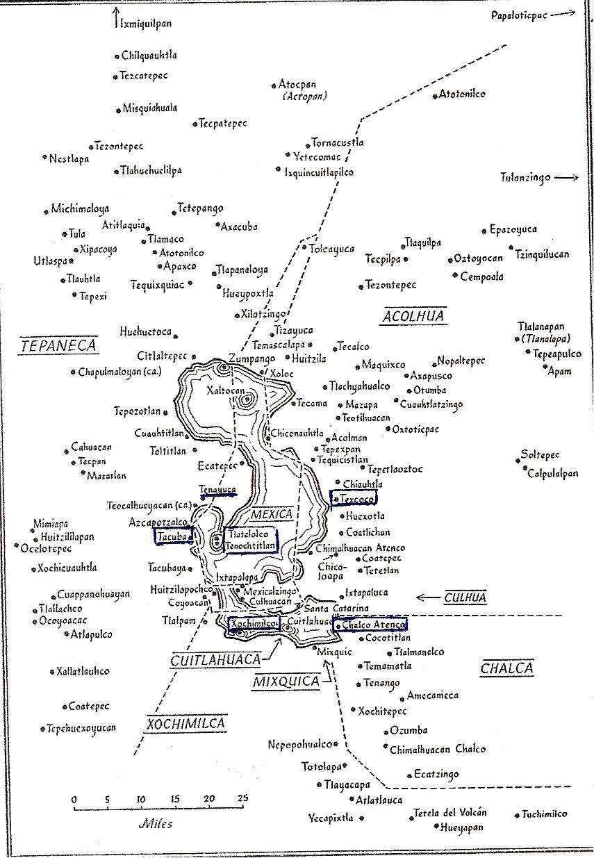
Tribal boundaries in the Valley of Mexico
at the time of the arrival of the Spanish in 1519.
From Gibson, Charles, The Aztecs Under Spanish Rule,
Stanford University Press, 1964.

The Triple Alliance


Three of the altepetls were the most powerful, having formed the Triple Alliance in 1428. It was this Triple Alliance that constituted what has been called the "Aztec Empire". In 1519, it dominated the other altepetls in Valley and other tribal city-states far beyond the Valley in what is now central Mexico. All the others paid tribute to one or another of the three. The Mexica of Tenochtitlan were the most powerful of the three and received the most tribute, but the other two were autonomous in regards to their internal government. They were the:
  • Acolhua, with their capital at Texcoco, on the east side of the lake. The second most powerful member of the Alliance, they did not pay tribute to the Mexica. Its territory is now in the State of Mexico.
  • Tepaneca, with their capital at Tlalcopan (called Tacuba by the Spanish), on the west side of the lake. Tacuba is now the cabecera, government headquarters, of  Delegación/Alcaldía Miguel Hidalgo in the City of Mexico.
The Triple Alliance was formally created after the Mexica, the Acolhua and the leaders of the Tepaneca town of Tlalcopan defeated the Tepaneca rulers in 1428. The Tepaneca had been the dominant force on the west side of Lake Texcoco for more than a hundred years. Their capital had been Azcapotzalco, which was destroyed in the war, so the capital was then moved a short distance south to Tlalcopan. They thereafter remained subordinate to the Mexica, but the rulers of their towns were allowed to continue to control internal matters and collect tribute — part was used to support themselves and part was shared with Tlalcopan.

The Other Altepetls


Two other large tribal groups were the 
  • Xochimilca, in the south, with their capital at the island city of Xochimilco, on the lake of that same name. They were among the earliest Nahua tribes to settle in the Valley, around 900 CE. They had been defeated, in turn, by the Culhua (see below) at the end of the 13th century, by the Tepaneca in the 14th century and, finally, by the Mexica in the early 15th century and their territory reduced. Their capital is now the cabecera of Delegación/Alcaldía Xochimilco.
  • Chalco, to the southeast, with their capital at Chalco-Atenco on the east end of Lake Chalco.  They were subjugated by the Mexica but rebelled from time to time. It is now a municipality in the State of Mexico.
Three smaller but still distinct tribes completed the population of the Valley. They were the
  • Culhua, with their capital, Culhuacán, at the west end of the Iztpalapa Peninsula, between Lakes Xochimilco and Texcoco. They had been a dominant force, controlling more territory, until they were defeated first by the Tepanecas in the 14th century, then by the Mexica in the 15th century. Culhuacán was then left controlling only three other towns, Iztapalapa and Mexicaltzingo on the tip of the peninsula, and Huitzilopochco (now the barrios of Churubusco), across the channel connecting the two lakes, in what is now Delegación/Alcaldía Coyoacán. Culhuacán is now divided into Pueblo Culhuacán in Delegacion/Alcaldía Iztapalapa and the adjoining Pueblo San Francisco Culhuacán in Coyoacán.
  • Cuitlahuaca, whose capital occupied an island dividing Lake Chalco from Lake Xochimilco. They never controlled much territory beyond a few nearby towns on the north and south lakeshore. It is now the cabecera of Delegación/Alcaldía Tláhuac (a shortened form of Cuitlahuac) which includes the pueblos it formerly controlled. 
  • Mixquica, whose capital, Mixquic, on the south shore of Lake Chalco was all they controlled. It is now Pueblo San Andrés Mixquic incorporated into Delegación/Alcaldía Tláhuac.
In 1521, Cortés' Spanish soldiers, together with indigenous allies both from within and outside the Valley, defeated the Mexica of Tenochtitlan and then went on to take control of all of the Valley, either by might or the voluntary submission of the other tribes. From Gibson, Charles, The Aztecs Under Spanish RuleStanford University Press, 1964.

Tenayuca


Tenayuca means "walled place" in Nahuatl. The archeological remains of Tenayuca are located in the originally indigenous Pueblo San Bartolo Tenayuca in the municipality of Tlalnepantla de Baz, in the State of Mexico. At the time the Spanish arrived, it was under the control of the Tepaneca (see above map of tribal territories), which it had been for some time before the Mexica became "the first among equals" in the Triple Alliance.

Tenayuca
lay at the northern-most end of the southwest bay
of Lake Texcoco.
During the time of Mexica/Azteca rule,
it was at the end of a long causeway
from Tenochtitlan/Tlatelolco.

Archaeological remains recovered from Tenayuca indicate that the site was first occupied in the Classic Period (100 to 600 CE), when Teotihuacan, in the northeastern part of the Valley, dominated the area. Its population increased in the early Postclassic (600-1100 CE) during the reign of the Tolteca based in Tula, outside the valley to the northwest.

It continued to increase after the fall of Tula (1150 CE), when, with the lack of a central dominating power, many nomadic tribes, generically called "chichimeca" [a pejorative term used by settled, agrarian peoples with urban centers, hence, "civilized", to denote nomadic hunter-gatherer tribes from the north] moved through the area formerly controlled by Tula and entered the Valley that was called Anahuac.

According to the Codex Xolotl, Tenayuca, itself, was founded in 1224 CE by Xolotl, ruler of a Nahuatl-speaking chichimeca tribe whose actual name is unknown. Xolotl was succeeded by Nopaltzin who married Atototztl, a Tolteca princess, in order to establish a linkage with the royal lineage of Tula, seen by all the new tribes as the epitome of a civilized society. When Nopaltzin died, his son, Quinatzin, transferred the seat of power to the east side of the lake that came to be known as Lake Texcoco and founded the altepetl (city-state) of Coatlichán. Quinatzin left a maternal uncle, Tenacacaltzin, to be lord of Tenayuca.

On or about 1337, another tribe, the Acolhua, defeated the chichimeca of Coatlichán and made Texcoco their capital city (see map of tribal boundaries above). Tenayuca allied itself with the Acolhuaswho dominated the northeast region of the Valley of Mexico in the mid-14th century.

However, in the late 14th century, Tenayuca was conquered by the Tepaneca of nearby Azcapotzalco. About a hundred years later, in the 1430s, after the Mexica of Tenochtitlan and their allies, the Acolhuas and Tlalcopan, conquered Azcapotzalco, bringing the Tepaneca under the control of the Triple Alliance, Tenayuca came under the control of Tlalcopan. It remained so until the Spanish came and conquered the entire Valley in 1521 (modified from Wikipedia).

The Temple of Tenayuca


Temple architecture that was built during the period of Mexica/Azteca dominance is based on that which originated at Tenayuca. It consists of a pyramidal base supporting two temples. The Mexica/Azteca adopted this innovative style for their own main temple, now known as the Templo Mayor, in the center of what was Tenochtitlan.

Pyramid of Tenayuca
with its stairway leading to what were two temples.

The archeological site consists of a massive pyramidal platform with a stairway rising on the western side to where the twin temples of Tlaloc (god of all waters, essential for agriculture, the basis of urban civilization) and Huitzilopochtli (son of the sun god, Tonatiuh and god of war, the Mexica's primary god) once stood. The temple of Tlaloc occupied the northern part of the pyramid while the Huitzilopochtli temple stood to the south. To the south of the stairway at ground level is a projecting platform bearing sculptures of crossed bones and projecting skulls. It is likely where human sacrifices were carried out or completed after being initiated in one or the other of the temples above.

Southwest platform of skulls and crossed bones.

Like many Mesoamerican temples, various phases of construction were built one on top of the other. In the case of Tenayuca, the size of the building increased through six phases of construction but the basic form remained unchanged. The original double pyramid was enlarged five times, the first time probably in 1299 and then successively at 52-year intervals [the cycle of the "tying of the years", when the first day of the 365-day solar calendar coincided with the 260-day divinatory calendar].

The last phase of construction probably dates to 1507 and measures 62 meters (203 ft.) wide by 50 meters (164 ft.) deep. Mexica/Azteca influence is apparent from the third stage, built in 1351, only twenty-six years after they founded Tenochtitlan. All the following stages were purely Mexica/Azteca in style, as demonstrated by the sloping, multiple tiers of the pyramid rather than the vertical walls apparent in the earlier stages.

Stages of enlargement of the pyramid
On-site Museo Xolotl

Painting of how the pyramid looked at its final stage in the early 16th century.

Wall of the Serpents


The pyramid base is surrounded on three sides by its most notorious component, a coatepantli (Nahuatl for a wall of serpents), a low platform supporting 138 stone sculptures of snakes. Their bodies were once covered with plaster and painted in a variety of colors, with their scales painted black.

Coatepantli, the Wall of Serpents


On the north and south sides of the pyramid, at ground level, are two sculptures of coiled serpents. The crests on their heads bear markings representing the stars and identify them as Xiuhcoatl (the fire serpent). All the serpent sculptures around the pyramid were associated with worship of fire and the sun.

Fire Serpent

Fire Serpent

Two hundred meters (about 220 yards) from the main pyramid of Tenayuca are the remains of what appears to have been an elite residential complex, with surviving plaster floors in some rooms. This area has been labeled Tenayuca II by archaeologists and appears to have gone through various phases of construction. Wikipedia

Acatitlán


About three kilometers (a little less than two miles) from Tenayuca, in the Pueblo of Santa Cecilia Acatitlán, is another archeological site. It consists of a small, reconstructed pyramid that was originally one of the earlier stages of construction that became enclosed within a larger pyramid. It was reconstructed in the 1960s. 

Pyramid of Acatitlán

Acatitlán was evidently a site subsidiary to Tenayuca. It is believed that after the Mexica took control of the area in the 15th century, the temple was dedicated to their god, Huitzilopochtli.

While we were visiting the site, there was a man standing on top of the pyramid, engaged in an indigenous ritual of venerating the four cardinal directions, the sun and heavens above and the earth below. 


On the man's T-shirt would appear to be the symbol of
the Mexica/Azteca Stone of the Five Suns,
representing the sequence of five creations of the world
until the Fifth Sun,
when humans with language were successfully
created by the gods, so they could worship those gods. 

Like virtually all indigenous temples in Mexico, this one was destroyed by the Spanish. The stones of the outer layers were used to construct the church of Santa Cecilia Acatitlán, which stands nearby. So here, in Acatitlán, we encounter a rare literal demonstration of the so-called Spiritual Conquest, the transformation of indigenous society into a Catholic Hispanic one, which we have been exploring since 2016.  

Church of Santa Cecilia Acatitlán,
built in the 16th century.

Wikipedia

A Glimpse at Indigenous Civilization in the Larger Valley of Mexico


Since we began our ambles in 2015, we have stayed within the boundaries of Mexico City for practical reasons of proximity and preservation of our limited energy. We have been well aware that there are still existing originally indigenous villages and archeological remains outside those arbitrary boundaries, all over the larger Valley of Mexico. We have, of course, been to the monumental site of Teotihuacan, one of the premier archeological sites in the entire world. It is located in a side valley to the northeast of the main Valley. Twenty-five years ago, during our first visit to Mexico, we went to the smaller, but still impressive site of Tula

Today, in our visit to Tenayuca and Acatitlán, we have encountered smaller sites, but ones barely outside the City. They are also sites that, unlike Teotihuacan and Tula, were still functioning communities when the Mexica/Azteca became the last people to dominate the Valley before the Spanish Conquest brought Mesoamerican civilization to an end. The Mexica/Azteca of Tenochtitlan took note of their strategic location at the north end of the bay which their city dominated in Lake Texcoco (see map of bay above) and incorporated them directly into their urban structure via a causeway connecting them to their capital. 

The archeological reconstructions of their prehispanic pyramids, set within the still-vital pueblos of Pueblo San Bartolo Tenayuca and Santa Cecilila Acatitlán, provide — like the Templo Mayor in the midst of Centro Histórico and the site of Tlatelolco, next to the Church of Santiago Tlatelolco — glimpses of the indigenous world that existed before its military Conquest by the Spanish and vivid examples of the dramatic transformation of that world that was the Spiritual Conquest that followed.

Saturday, November 11, 2017

Mexico Before the Spanish: Cuicuilco, Volcanoes and the Fragility of Life in Mesoamerica

Non-Mexicans often assume that the Aztecs or Mexicas of Tenochtitlan were a long-standing civilization in the Valley of Mexico. However, they were, in fact, late arrivals, entering the Valley in 1225 CE. Other Nahua speaking "Aztecs" had arrived a century or two before them. The Mexicas were hunter-gatherers, chichimechas, i.e. barbarians in the eyes of the the argrarian, urbanized peoples of the Valley. They did not begin to build their own city, on a group of islands in Lake Texcoco, until 1325. They did not come to dominate the Valley, and Central Mexico until they defeated rival city Azcapotzalco in 1428, barely one hundred years before the Spanish arrived.

In fact, the first monumental civic-ceremonial center in the Valley was Cuicuilco. Cuicuilco was first settled about 1200 BCE. By 800 BCE it was a thriving civic-ceremonial center. Sometime around 150-200 CE Cuicuilco was utterly destroyed by ash and lava flow from Xitle, a small cone volcano nearby. But we´re getting ahead of ourselves.

Volcanic Axis Runs through Mexico City's 'South Side'

Living in Michoacán, we had become acquainted with the Volcanic Axis running East-West across Mexico. So many volcanic craters are visible that 'flying' over Michoacán via GoogleEarth, Reed exclaimed, "is like viewing a moonscape."

Volcanic Axis (red) cinches Mexico's midsection;
four black triangles represent the largest volcanoes: (West to East)
Colima (active);
Popocatéptl (active), linked by a mountain ridge to Iztaccíhuatl (dormant);
La Malinche (dormant 3,100 years); and
Pico de Orizaba 
(active, indigenous name is Citlaltépetl), 
 Reaching 18,406ft.,

i
t is the tallest mountain in Mexico and third tallest mountain in 
North America.

Lake Texcoco:
Red lines indicate Volcanic Axis;
Cuicuilco is on West Side (left, triangle just below top red line);
Cerro Xitle (Extinct Volcano) is Southwest of Cuicuilco;
North of Cuilco is site of Tenochtitlan, (today's Mexico City Historic Center).

"If you would understand a man, walk a mile in his sandals..."

I've taken liberties with this traditional saying, because it is a useful reminder as I try to understand the circumstances of Mexico's earliest peoples—specifically, how they coped with natural forces that periodically threatened to destroy them. (See our: Geography: Ground of Mexico's History and Culture. Here our focus is on volcanic activity.

Mexico's volcanoes are of two types:
  • Large, violently erupting volcanoes characterized by long periods of repose between eruptions (Popocatépetl); and
  • Smaller volcanoes that tend to form and erupt where there has been no previous volcanic activity; once eruption occurs, the activity shifts to a new locality where an eruption occurs at a later time (Paricutin, Michoacán, the most recent, which erupted between 1943 and 1952 ... and Xitle).
Xitle, in fact, formed on the flank of Ajusco, a larger volcano in the same area. When Xitle erupted, lava flows poured into the Basin of Mexico, covering the area of what is now known as the Pedregal de San Ángel, upon which has been built the campus of the National Autonomous University of Mexico [UNAM].

Cuicuilco's First Settlers

Cuicuilco provides a rare snapshot of life in these early periods. The first peoples to settle Cuicuilco about 1200 BCE were small family groups making the transition from hunter-foragers to village-based farmers. Their agriculture was based on cultivation of maís (corn).

During this period, the central and southern regions of the Basin of Mexico (modern-day Mexico City) enjoyed greater rainfall, which fostered settlement of tribal farming villages. The well-watered valley floors were green with maís, and irrigation techniques enhanced crop yields. People continued to hunt and trap and collect important (often medicinal) plants. The landscape was clearly divided between cultivated land and the wilderness—forested mountainsides that served as watersheds for the valley, dotted with natural springs, the source of small rivers that supplied the lakes.

In the eyes of these early settlers, their farming villages and milpas (farm plots in Nahuatl) represented the point of connection between heaven and earth—a fruitful union of water, earth and mountains. The earth was viewed as the milpa of the gods. Outside the milpa, chaos reigned. In this worldview, prosperity sprang from proper regulation of the agricultural (solar) year, and from effective mediation with controlling natural forces, which were viewed as spiritual in nature.

At Cuicuilco, Cerro Xitle (Xitle Hill) would have been an active presence, spewing smokey plumes as Popocatéptl does today, providing a daily reminder of the people's vulnerability before la naturaleza (natural forces). The natural follow-up question is: How might these early settlers have sought to 'mediate' let alone 'regulate' these natural forces?

Cuicuilco: Monumental Civic-Ceremonial Center

Perhaps the best answer to that question is found in the words of renowned art historian George Kubler (1984):
"[The people engaged in] collective endeavors to guarantee the continuity of the creation of the universe against catastrophic dissolution in an unstable world." (Emphasis added)
In this context, Cuicuilco presents a good example of how Mesoamerica culture attempted to control the vital forces of the natural world by replicating them in ritual practices. The deity most associated with Cuicuilco was Huehuetéotl (Old Old God of Fire).

Huehuetéotl (Old Old God of Fire)
He is depicted as an old man with wrinkled face (symbol of wisdom), 
On his hat—a brazier for burning coals or incense—is carved the fire symbol.
National Museum of Antropology

Also evident at Cuicuilco is evidence of a cult to the fertility of the earth is found in the numerous clay sculptures of fecund women (Cuicuilco Museum) uncovered in private homes. This cult demonstrates the community’s recognition of their dependency on natural forces to assure ample harvests.

The elaborate peinado (hairstyle) of this female figure
—dubbed 'Pretty Woman'—
is undoubtedly an early symbol of fertility.

Generally understood to be a god of the family hearth rather than a focus of civic ritual practice, Huehuetéotl nonetheless appears on a 13 ft. (4 m.) stele (stone-carved column) outside Cuicuilco's "pyramid". The "pyramid" is actually a truncated, stepped cone with ramps on its East and West sides.

Cuicuilco's "pyramid"
Its summit was crowned by an altar
where the smoke of burning incense and sacrifices rose to the heavens.

The pyramid was constructed in several stages, beginning in 800-600 BCE and hence contemporaneous with one of Popocatépetl's violent eruptions. By 100 BCE, Cuicuilco's population was about 20,000—large enough to support the pyramid construction that continued across generations until about 200 BCE.

Retaining walls of pyramid at Cuicuilco

Both the hearth god and the monumental conical pyramid are earthly replications of Xitle, the conical smoking mountain whose presence posed a constant threat to Cuicuilco's inhabitants.

Cuicuilco Museum offers this explanation of how a tribal farming village underwent the transition to become a monumental, regional civic-ceremonial center (our translation):
"A more elaborate religious cult gradually developed at Cuicuilco where an incipient elite performed not only religious rites, but political and administrative functions as well. Over time, this elite solidified its control over the entire population and, by so doing, initiated a process that ultimately defined a theocratic government."
It is not known exactly when Xitle erupted, but it likely occurred sometime between 200 BCE and 200 CE.

It is known that Popcatépetl's eruptions from 250 BCE to 50 CE severely disrupted southern Basin communities. It is also known that Xitle first spewed ash falls, followed shortly thereafter by lava flows. By the time Xitle erupted, with spectacular and frightening displays of fire and smoke, its effects would have caused Cuicuilcans and others to flee for their lives.

Archeological evidence indicates that when the Cuicuilcanos fled the ash falls and lava flows, some sought refuge across the lake at the village or city of Huizachtécatl, now Culhuacán, at the base of Cerro de La Estrella (Hill of the Star), on the peninsula of Iztapalapa. Others fled to Teotihuacán, which was, by that time, the dominant power in central Mexico.

Cuicuilco was buried by Xitle's eruptions: lava flows reached a depth of about 10 m. (33 ft.) and extended over about 80 sq. km. (32 sq. miles)The archaeological context was sealed so thoroughly that excavation at the site has proceeded with jackhammers—not ideal for preserving detail!

Aftermath of Volcanic Eruptions

It is difficult to overstate the psychological impact on early peoples of natural phenomena associated with Mexico's volcanic eruptions. But given the people’s proximity to these natural events, it is equally difficult to dismiss the idea that volcanic activity had a profound impact on how Mexico's early peoples came to view their world. Perhaps the most vivid example is found in the Aztec Creation Myth of the Five Suns.

In a nutshell:
It took the gods five trys at creating the heavens and the earth, known as the Five Suns. The Third Sun (World, or Era) was destroyed by the 'Rain of Fire', likely a volcanic eruption. The Fourth Sun was, in turn, destroyed by water (drought and flood). Then the gods sought to recreated the earth for the fifth time, but there was no light, no sun. Meeting in darkness around a great fire, two gods threw themselves into the pyre. The first became the Sun, the second the Moon.  Thus was the creation of the Fifth Sun, the era of the Aztecs.
In a profound expression of the duality that marks Mesoamerican thought, it is fire in the form of the sun that gives life to the earth through maíz, and it is fire in its various forms, including volcanic activity, that just as easily takes life.

Originally published in Jenny'a Journal of Mexican Culture.

Cuicuilco
lies near the middle of the northern boundary of Delegación Tlalpan,
the most southern borough of Mexico City.
The site is just south of the Periferico (Ring Higway) and east of Ave. Insurgentes.
Delegación Coyoacán is to its north;
Delegación Xochimilco lies to the east.

Saturday, May 13, 2017

Green Spaces | Chapúltepec Woods: From Bustle to Tranquility, Present to Past


A Shift in Perspective


Up until now, our focus in Mexico City Ambles has been on how the cityscape embodies the city's long and complex history. We have concentrated on whole neighborhoods (called colonias, pueblos or barrios depending on their origins) and the buildings and other features that give them their unique character and identify their place in the development of the city's narrative. Where those features include plazas, parks or other forms of "green space", such as tree-lined boulevards, like Paseo de la Reforma, we have presented them, but we have not looked at them from a generic perspective.

Occasionally, we have written posts about generic qualities of the city, such as its efforts to communicate grandeza (grandeur)
, its Baroque and "California" Neo-colonial architecture, the range of markets and street commerce and the role of ritual in maintaining communal identity. So it occurred to us that looking at the city's wide variety of green spaces as a topic in and of itself would be not merely interesting, but perhaps even revealing of another aspect of the city's character. 

From that perspective, we reviewed the posts we have published over the past two years to see which included presentations of some form of green space: plazas, parks, boulevards, gardens, interior courtyards (patios). Only one, on Chapultepec Woods, the huge park west of Centro, is solely about such a space. However, a dozen or so other posts include such green spaces as a significant part of their urban character. The colonias developed during the Porfirato (dictatorship of Porfirio Díaz, 1876-1911) and the first decades after the Revolution (1911-17), such as La Roma and Condesa, sought to imitate Parisian elegance, including arboladas (tree-filled) plazas, parks and boulevards. 

Other colonias, such as Villa CoyoacánMixcoac and San Ángel, which have maintained their Spanish Colonial design, centered around central plazas and large church atrios (atriums), thereby also contain significant green space. Xochimilco, with its indigenous chinampas, man-made islands, and its evergreen-covered foothills, is particularly green. 

So we begin our new perspective on the City's green spaces, and a new series of posts, by republishing the one on Chapúltepec Woods.

Chapúltepec Woods


Two things drew us to the Bosque de Chapúltepec (Chapúltepec Woods): one was our ongoing search for a tranquil retreat within the bullicio, the bustle of the city. The other was to see how chilangos, Mexico City residents, spend their leisure time on a Sunday afternoon. Interestingly, we found that tranquillity and leisure time don't necessarily go together in Mexican culture.

Exiting the Chapúltepec Metro Station on Line 1, the Pink Line, on a sunny Sunday afternoon, we are caught up in a stream of families headed for the park. It is rush hour for relaxation. Typical of many Metro stations, the street level is thick wtih vendors selling food, caps, binoculars, bottled water and any number of other items. As elsewhere, we have to wend our way through this labyrinthian mercado to reach our destination.


Entering Chapúltepec Park

Inside, families are headed for a wide pedestrian bridge across a major expressway to enter the main part of the park. This promenade was originally the route of the Paseo de la Reforma which Emperor Maximilian had built during his brief and conflictual reign (1864-67) to connect his chosen residence, Chapúltepec Castle, with the city center, now the Centro Histórico, to the northeast. Reforma has been re-routed along the north side of the park and extended west to the city's boundary with the State of Mexico.


Chapúltepec Castle
above the Monument to the Niños Héroes, the Boy Heroes,
military cadets who fought to their deaths against U.S. forces
taking Mexico City in the Mexican-American, War 1847.


Paseo de la Reforma
seen from Chapúltepec Castle.
Six White Columns are the
Monument to the Boy Heroes
Photo by Carlos Cortés
Wikipedia


Family relaxing in the shade of the park's many trees.

The Bosque de Chapúltepec (Chapúltepec Woods) is one of the largest city parks in the Western Hemisphere, measuring in total just over 1,695 acres (686 hectares) (Central Park in New York City is half its size, with 843 acres, 341 hectares). The name "Chapúltepec" means "grasshopper hill" in Nahuatl and designates a volcanic formation called Chapúltepec Hill.


Aztec glyph of Chapúltepec,
in Capúltepec Castle

Perhaps the America's Oldest Continuously Used Park

The park area has been inhabited and held apart as special since the Mesoamerican era. Remains of Teotihuacan (500 BCE to 500 CE) and Toltec (800 to 1000 CE) cultures have been uncovered. When the Mexicas/Aztecs arrived in the Valley, then called Anáhuac, in the mid-thirteenth century, they settled here first, until they were kicked out by the Tepanec lord of Azcapotzalco, just to the north.

When the Mexicas/Aztecs became established in their island city of Tenochtitlán and defeated Azcapotzalco in the 15th century, they turned Chapultepec into a royal retreat. One notable site, of which there are some ruins, is the Baths of Moctezuma, a system of cisterns, reservoirs, canals and waterfalls. Because of its springs, the Mexicas built aqueducts across the saline lake to supply Tenochtitlán with fresh water. A temple sat atop Chapúltepec Hill.

After the Conquest in 1521, the Spanish King declared that it should remain a natural space for Spanish residents of the new city. It was not open to its original indigenous peoples or to any mestizo, mixed-race offspring of the two razas, races.

Fountain that marked the beginning of the aqueduct built by the Spanish
to carry fresh water from Chapúltepec's springs to the city on the island.

Today Chapúltepec is every chilango's backyard, one of the few constants in a city that has otherwise changed dramatically over nearly five centuries. Immediately to the west of the park, along Reforma, are the upper-middle class colonias, neighborhoods of Cuauhtémoc and Benito Juárez. To the south are La Roma and Condesa, the colonias developed at the end of the Porfiriato period (1876-1911) and after the Mexican Revolution. We have spent considerable time exploring and comparing them. To the northwest are wealthy colonias built in the mid-20th century: Polanco and the various Las Lomas, part of the Delegación, Borough, of Miguel Hidalgo, to which the park also belongs.

Today, the park is divided into three sections. The first section is the original. Still the most visited, it contains most of the park's attractions including a zoo, the Museum of Anthropology, the Rufino Tamayo Museum and the Museum of Modern Art along Reforma.  Chapúltepec Castle, about which we´ve written, now serves as the National History Museum (its website provides a virtual tour).

Un Paseo ... Stroll Through the Park

Following the crowd along the former Reforma, we turn right past the Monument to the Niños Héroes and come to a wide promenade, la Gran Avenida, Grand Avenue, an oval that circles through the first section of the park. In earlier days, carriages could be driven around it; later, automobiles traveled on it during Sunday drives, but today it is reserved for pedestrians. It is lined with puestos, stalls selling various kinds of souvenirs. 


3 T's for 150 pesos, about $9

Lucha Libre, Free Wrestling masks


Payaso, Street Clown

Farther along the Avenida, we come to Chapúltepec Lake, or is it Central Park Lake?


Past the lake is the Zoo. At this point, the park's ambience changes dramatically. The promenade of families reaches its destination and virtually disappears. Beyond this point lies the tranquility that we are seeking. The park becomes a quiet wooded retreat, an almost private space. La Gran Avenida becomes a path for a quiet stroll.

Tranquillity Amidst Millions


Yes, this is Mexico City with its 8 million people, in a metropolitan area of 21 million. By the way, when we visited it was December!

Saturday, November 26, 2016

Mexico City's Original Villages | Tlatelolco: Where Empires Clashed

When Hernán Cortés and his Spanish troops arrived in the Valley of Anáhuac (now the Valley of Mexico) in 1519, Tlatelolco was essentially merged with Tenochtitlan. Its excavated remains are located two kilometers (about a mile) north of Tenochtitlán (now represented by the remains of the Templo Mayor, in Centro Histórico).

Tlatelolco had been founded in 1337, by a group of dissident Mexica who broke away from the leadership of Tenochtitlan, which had been founded only twelve years earlier, in 1325. They established Tlatelolco on another island just north of Tenochtitlan. Both cities were subject to the dominant altepetl on the west shore of the lake, Azcapotzalco. About one hundred years later, in 1428, Tlatelolco joined Tenochtitlan, along with two other atlepetls, Tlacopan and Texcoco, in overthrowing the rulers of Azcapotzalco. Tenochtitlan became the dominant power all the area around Lake Texcoco and then the entire Valley and beyond.

After nearly fifty years of more or less peaceful coexistence as physically and ethnically close neighbors, in 1473, Tenochtitlan, having become the power controlling all of what is now south-central Mexico, attacked Tlateloloco and took it over, subsuming it into their city.

Today. Tlatelolco is surrounded by modern apartment buildings and major boulevards. We might have taken Metro Line 3 to get there, but we chose a taxi instead.

Mexica temples of Tlatelolco (14th century) stand in front of Church of Santiago, St. James.
The Franciscans first built a "hermitage", a small chapel. 

It was replaced by a larger church in 1545 and enlarged further in 1609.
Convent stands to the right.

(See: Portraying Mexico City's Azteca/Mexica Origins)

A Center of the Spiritual Conquest

After the Spanish conquered the Mexica in August, 1521, they immediately razed to the ground all the temples and pyramids of Tenochtitlan and Tlatelolco. They claimed the center of Tenochitilan for themselves and built their own temples and palaces above the ruins. Tlatelolco was assigned as a barrio for the defeated Mexicas. In the early 1530s, the Franciscans, who had been sent from Spain to convert the native population to Catholicism, soon built a church and convent (monastery) at the sacred and now culturally and politically crucial site.

The convent was established as the Imperial College of the Holy Cross, a school to educate the sons of Aztec noblemen in Spanish culture and train them for the priesthood, a core strategy of the Spiritual Conquest, to convert indigenous religious beliefs and culture into a Spanish Catholic one. According to legend, it was to this convent that Juan Diego, an indigenous convert, was headed in December 1531, from Tepeyac, on the northern shore of Lake Texcoco, when he was confronted by a vision of the Virgin of Guadalupe, the quintessential representative of the Spiritual Conquest.

It is telling that when the indigenous students began surpassing their Spanish teachers, the Spanish king and Church hierarchy found ways to restrict the curriculum. Eventually, they closed the school entirely.

Interior patio of the Franciscan convent, 
Imperial College of the Holy Cross

The convent also became a center for the study of Mesoamerican cultures. It was here that the Franciscan priest Bernardo de Sahagún wrote his History of the Things of New Spain, the seminal work on Aztec culture that remains a highly regarded source text.

Contemporary Plaza of Three Cultures

In recent times Tlatelolco was renamed Plaza de las Tres Culturas (Plaza of Three Cultures) because the structures there give living testimony to the cross-cultural process that created mestizaje, racial mixing, in Mexico. Most Mexicans regard themselves as mestizo, as having both indigenous and Spanish ancestors.

The ruins of the original center of Tlatelolco are dwarfed, on their south side, by a modern office tower that formerly housed the Secretariat of Foreign Relations, but today is occupied by a campus of UNAM (National Autonomous University of Mexico). On the east side sits the Church and Convent of Santiago Tlatelolco, the colonial hinge between the country's Mexica-Aztec heritage and today's Republic of Mexico.

The plaza at Tlatelolco has been the setting of three tragic events in Mexican history, one ancient and two modern, making it a symbolic place of much emotional power:
  • August 13, 1521: After their defeat at Tenochtitlán, the Mexicas fled to Tlatelolco where they again faced the Spanish and their indigenous allies seeking to overthrow Mexica domination; overrun, the Mexicas, led by huey tlatoani, "head speaker" Cuauhtémoc, surrendered; 
  • October 2, 1968: Just before the opening of the Summer Olympics in Mexico City, the Mexican Army opened fire on a student demonstration, killing hundreds of students; 
  • September 19, 1985: major earthquake (7.8 Richter) shook Mexico City; several Tlatelolco high-rise apartment buildings, built in the 1970s, collapsed like accordions—the tragic consequence of builders who had lined their pockets by taking shortcuts with building materials and methods; the death toll was in the thousands.
Sign reads:

"On August 13, 1521, 

heroically defended by Cuauhtémoc, 
Tlateloloco fell under the power of Hernán Cortés.
Neither a triumph nor defeat; 
it was the painful birth of the mestizo people
that is Mexico today."
Source: Eduardo Aguilar-Moreno, Aztec Architecture;
Photo: Fernando González y González.

A Short History of Tlatelolco


Tlatelolco lay about one mile north
of its sister Mexica atepetl of Tenochtitlán,
originally on a separate island.
After the Tenochtecas defeated the Tlatelolcas in 1473, 

it was politically and physically joined to Tenochtitlán.

Like Tenochtitlán, Tlatelolco was built on a muddy island in Lake Texcoco. In the middle of the 14th century A.D., a group of Mexicas split off from the main tribe who had founded Tenochtitlán in 1325.
The dissidents didn't go far. They established their new community about a mile north of their home city and named it Tlatelolco—some scholars assert that the name derives from the word tlatelli, meaning 'built-up mound of earth'. And, after all, they were still Mexicas. So it's not surprising that their founding myth parallels Tenochtitlán's:
...a whirlwind had led them to an island with a sandy mound upon which rested a round shield, an arrow, and an eagle—strongly reminiscent of Tenochtitlán's cactus, eagle, and snake.
They petitioned Tezozómoc, the tlatoani, chief speaker of Aztcapotzalco, a Tepanec atepetl on the west side of the lake, for a king who would link them to the historic dynasties of central Mexico. From Aztcapotzalco, the Tepanec, another Nahuatl speaking group, controlled the west side of Lake Texcoco. Tezozómoc gave them his son, Cuacuapitzáhuac, who was also kin to Tenochtitlán's dynastic clan [Andrew Coe, Archaeological Mexico, p. 86].

Under their new ruler, Tlatelolco became part of the Valley of Mexico's intricate network of tribute relationships. In return for its protection, its rulers had to pay tribute to Aztcapotzalco in both staples and luxury goods. The Tlatelolcans also had to fight for Aztcapotzalco against its rivals.

Tlatelolco Finds Its Niche: Trade and Tribute


Tenochtitlán was Tlatelolco's major rival. Fortunately, Cuacuapitzáhuac cannily identified an empty niche: trade. He established the first large-scale market and instituted what would become the Tlatelolcan tradition of pochtecas, or long-range merchants.
At first, the pochtecas confined their trips to the Valley of Anáhuac (now Valley of Mexico), but eventually they ranged to the very edges of Mesoamerica: east to the Gulf of Mexico (Veracruz); west to the Pacific Ocean; south to Oaxaca and Chiapas—even as far as present-day Guatemala and Honduras; and north as far as the deserts inhabited by the "Chichimeca" ("barbarian", hunter-gatherer) tribes. Not only did the pochtecas learn the language and customs of foreign tribes, but they often acted as spies by collecting strategic information in advance of the Mexica-Aztec army.
Eventually, Tlatelolco's pochtecas controlled long-distance trade in the luxury goods (quetzal feathers, turquoise) deemed essential for Mexica political and religious life. After the Mexica-Aztecs and their allies of Texcoco and Tacubaya defeated their principle rival, the Tepanecs of Aztcapotzalco, the Aztec hegemony spread throughout central Mexico spearheaded by Tenochtitlán warriors and Tlatelolco merchants, who established trade routes from newly conquered peoples back to the Valley of Mexico.
Cuacuapitzáhuac's son Tlacatéotl moved the city market into a large plaza near the main ceremonial center. At its new location, the market soon became the hub of an extensive trade network; quite probably, it was the largest market in the Americas prior to the arrival of the Spanish.

The level of activity in the market strains credulity. Every day, as many as 20,000 vendors and market-goers crowded into the market square. Every five days, it is estimated that closer to 50,000 or even 60,000 people passed through the market!

The stalls were similar to those seen on Mexican streets today—mats covered by fabric shades for protection against sun and rain. Vendors were of two types, artesans bringing the labor of their own hands and merchants bringing wares from outside the city.

There was no money as such. Exchanges were arranged either by trueque (barter), or by using cacao seeds or salt as the medium of exchange. The Tlaltelolco market also had a tecpan, or house of judges, that resolved disputes and dealt with robberies, or whatever other issues that might arise. Punishments were severe and swift. The punishment for robbery was mandatory death by stoning.

Tlatelolco Loses Its Independence


In the 1420s, the Tenochtecas formed their famous Triple Alliance with the the Tepanec atepetl of Tlacopan, just south of Aztcapotzalco, and the atepetl of Texcoco, developed by the originally Otomí-speaking Acolhua people on the east side of the Lake. Together, they defeated Aztcapotzalco and took control of its tributary atepetls and villages. Tlatelolco remained an independent sister city-state.

However, in 1473, Tlatelolco was taken over by Tenochtitlán and then administered by a military governor. The new arrangement didn't affect the Tlatelolcan merchants, who continued to travel and bring back wares from throughout Mesoamerica. But Tlatelolco did lose important rights as an independent city-state—most significantly, the right to collect tribute and the right to perform important religious rites. In war, Tlatelolco's proud warriors were demoted to porters.

Tlatelolco, however, continued to play an important role for the dominant Tenochtecas. In fact, on Hernán Cortés's first visit to Tenochtitlán, the ruler Moctezuma the Younger took the Spaniards to visit the Tlatelolco market. Bernal Díaz, a soldier with Cortés, later wrote:
"...we were astounded at the great number of people and good quantities of merchandise, and at the orderliness and good arrangements that prevailed, for we had never seen such a thing before."
Taken to the top of Tlatelolco's great pyramid, the Spaniards enjoyed an excellent view of the entire city and the surrounding lake. Díaz wrote:
"We saw [pyramids] and shrines in these cities that looked like gleaming white towers and castles: a marvelous sight."
In the face of the Spanish incursion, Tlatelolco remained loyal to Tenochtitlán. When, in 1521, Hernán Cortés and his soldiers returned to attack Tenochtitlán, along with thousands of warriors from other city-states fed up with harsh Mexica rule, Tlatelolco remained on the side of Tenochtitlán.

Tlatelolco: A Walk Through Space and Time

Serious archaeological work began at Tlatelolco in 1944 and continues to the present day.

Archaeological investigation at Tlatelolco:
Worker cleaning an artifact—Yes, he's using a Q-Tip!

Like other indigenous ceremonial centers in Mexico, Tlatelolco was designed to reflect the Mesoamerican cosmovision. The diagram below shows the layout. The yellow line is the walkway that visitors follow through the site. The site is oriented to the four cardinal directions: visitors enter at the southwest corner; both the Great Temple and the altar of Santiago-Tlatelolco Church face east. The modern office tower rises on the south side (lower right).

Site map of Tlatelolco ceremonial precinct (green) with
Santiago (St. James) church and Franciscan convent (red).

In our amble through the site we pay particular notice to: (1) Temple of Ehécatl-Quetzalcóatl; (3) Tzompantli Altar - south; (4) Temple of the Calendar; (5) Priest's Palace; (7) core Great Temple Pyramid; (8) Successive pyramid walls constructed over time. The unnumbered blue rectangle in front of the convent is the Sacred Well, discussed below.

Temple Of Ehécatl-Quetzalcóatl (1)


The first temple we encounter is one that was dedicated to Ehécatl, the wind deity, who was a manifestation of Quetzalcóatl, the feathered serpent. The temple consisted of a semicircular base that wound into a circular staircase, platform and cone-like roof.

Its entrance was shaped like a snake’s mouth, symbolizing Quetzalcóatl. Construction of this temple dates back to the early times of Tlatelolco. Other structures were subsequently built over it.

Temple of Ehécatl-Quetzalcóatl
Ehécatl is the manifestation of Quetzalcóatl as the wind.

Temples dedicated to Ehécatl, god of wind, are generally of a circular shape to reflect the swirling wind. Since winds come just before the rains, Ehécatl-Quetzalcóatl and Tlaloc (god of water) often appeared together—as they did, for example, at the dual pyramid, Temple of the Feathered Serpent, at Teotihuacán. Here at Tlatelolco, deposed from his primal role at Tlaloc's side, Quezalcóatl was assigned his own, secondary temple space.    

Spiral from the back wall of Great Temple.
Spirals symbolize the whirling winds of Ehécatl-Quetzalcóatl.

Tzompantli Altar - South (3)


This altar is one of two; the other is on the north side of the site.

Tzompantli, site of a wooden skullrack.
White columns in the background belong to office building.
Its construction involved razing some smaller temples on the site.

According to Mary Miller and Karl Taube (The Gods and Symbols of Ancient Mexico and the Maya, p. 176):
"One of the more striking structures of Mesoamerican public architecture was the tzompantli, or skullrack. This was a wooden scaffold containing human skulls pierced horizontally by crossbeams.... 
"In the Quiché Maya popul vuh [story of the origins of the Maya, beginning with Creation], the severed head of the hun hunapu [father of the legendary twins who created  corn and humanity] was hung in a gourd tree next to the ballcourt. This gourd tree is clearly a reference to the tzompantli filled with human skulls. In Nahuatl, the term for head is tzontecomatl, with tecomatl signifying gourd tree. It appears that, like the Sumbanese skull trees of Indonesia, the tzompantli was considered as a tree laden with fruit."

Temple of the Calendar (4)


The next structure that greets us is the Temple of the Calendar. It was an especially significant structure because one of the primary duties of the priests was establishing and maintaining the temporal structure of life and the culture.

The Temple of the Calendar bears the symbols of the Tonalpohualli (divinatory) calendar. The Mexica-Aztecs, as did all the peoples of Mesoamerica, used two calendars:
  • The Xiuhpohualli was the Solar Calendar, which consisted of 360 days divided into eighteen, twenty-day "months"—each month presided over by a god, whose festival was celebrated that month. The Solar Calendar was also used to organize commerce and date the all-important tribute collections. 
  • The Tonalpohualli was the Divinatory Calendar, which consisted of 260 days—possibly based on the human gestation period—created by combining a sequence of twenty day-names with the numbers one to thirteen in rotation. This calendar was used to foretell the fate of individuals based on their date of birth. 
Priests also consulted the Divinatory Calendar in advance of government or family actions to be taken—to wage war, for example, or to celebrate a royal wedding—in order to determine the day's balance of favorable and unfavorable energy. When a date was characterized by unfavorable energy, the energy balance could be ritually addressed to influence a more favorable destiny.
    Temple of the Calendar 

    Representations of day-names, inscribed on three sides, were originally painted in blues, reds and whites. Following are some of the inscriptions of day-names and number combinations. The number is indicated by circles at the margin.

    One-Itzcuintli (One-Dog)


    Two-Tochtli (Two-Rabbit)

    Four-Ollín (Four-Motion, or Life-Force).
    The center of the symbol is a circle 
    representing the axis mundi, world axis, 
    which links the heavenly plane (above) 
    with the earthly plane (horizontal 'bar') 
    and the underworld (below).

    Cuauhtli (Eagle)

    The temple base also had multi-colored paintings with figures that relate to Tlatelolco's history. 

    Priests' Residential Complex (5)


    Each deity in the ceremonial precinct had its own priests, who were housed within the ceremonial precinct. Priests were responsible for maintenance of the temples associated with the cult of the deity to which they belonged.

    The residential structure for the priests consisted of an altar and two sections adjoined by a central corridor with a chimney like area for burning wood.

    Priests' Residential Complex

    Behind (east of) the priests' complex was the sacred well:
    "[It] resembles a ... swimming pool, [with a staircase] that leads to the sacred well...approximately 3 meters [almost 10 feet] wide. Scholars believe it may have been used for ablution practices or as a sacred spring." Eduardo Aguilar-Moreno
    Because of Mesoamericans' dependence on agriculture, water has been a primary concern from earliest times. Oceans, mountains and springs were worshiped as sources of water.

    Tlatelolco's Great Temple (7), (8)


    Tlatelolco's ceremonial complex was dominated by a typical Mexica double pyramid similar to the Great Temple at Tenochtitlán in Centro Histórico:

    Following the walkway, we pass the 'layers' of expansions (8) 
    to Tlatelolco's Great Temple, added by successive rulers. 
    The large rectangular platform at the back is the original Temple (7).

    Double Staircase of Great Temple.
    The near staircase (which has a split to show yet another level beneath)
    ascended to the temple of Huitzilopochtli (sun god and god of war); 
    on the far side is the staircase to the temple of Tlaloc (water god).

    Since 1978, the prominent Mexican archaeologist Eduardo Matos Moctezuma has been in charge of excavation of Tenochtitlán's Templo Mayor. Writing in 1988, Matos observed that the pairing of Tlaloc and Huitzilopochtli represents the essential duality fundamental to the Mesoamerican cosmovision in general and to the Mexica-Aztec cosmovision in particular. As a pair, Tlaloc and Huitzilopochtli represent key dualities: water and war; food and tribute; hence, life and death. Stated differently,
    • Tlaloc (Water God) = Water yields yields Food (maíz, corn) which yields Life
    • Huitzilopochtli (Sun God, God of War) = War yields Death and Tribute 
    This duality represents a tectonic shift in the Mesoamerican cosmovision. Before the late-arriving Mexica-Aztecs ascended to power in 1430, the Mesoamerican deities were forces of nature—Tlaloc, god of water; Quetzalcóatl-Ehécatl, god of wind, etc. But the Mexica-Aztec god Huitzilopochtli is a political god, a god of war—hence, a god of power based on military conquest and, as noted earlier, a god of economic power grounded in tribute. The parallels between the basic assumptions of the Mexica-Aztec empire and how the Spanish king would come to view Nueva España, as a souce of imperial income, are striking.

    Double Staircase of Great Temple.

    Note the short 'runs' and steep 'rises' of the stairs. 
    The steep pitch was intentional, 
    to remind climbers that they were ascending 
    to where they would encounter the gods.

    The modern tower in the background formerly housed
    Mexico's Secretariat of Foreign Affairs;
    today it is a campus of Mexico's National Autonomous University (UNAM)
    and houses the new, outstanding Site Museum of Tlatelolco

    Back and side walls of Great Temple pyramid. 

    Stones and Symbols of a World Transformed

    Our amble though Tlatelolco has given us as direct an encounter as is possible with representations of the indigenous political, cultural and religious foundations of Mexico and their attempted replacement by the parallel political, cultural and religious world of imperial Catholic Spain. All of this is surrounded by high-rise office towers and apartment buildings that bespeak modern Mexico. The space is aptly named the Plaza of the Three Cultures.

    It is sobering and moving to come face to face with the landmarks of these confrontations and transformations, so vividly manifested in timeless stone and changing symbols.

    Tlatelolco's ruins are marked by yellow star.
    Blue area around it is contemporary Colonia Tlatelolco.
    Tenochtitlán's Templo Mayor is marked by blue star.
    Yellow area around it is Centro Histórico and its four adjacent subdivisions.

    See also:
    Tlatelolco: Twin City of Aztec Capital, an earlier version of this post, on Jenny's Journal of Mexican Culture, which contains additional references to source materials.
    Aztec Stone of the Five Suns for more information on the Mesoamerican calendars, (Jenny's Journal of Mexican Culture).