Discovering Pueblo San Juanico Nextipac | An Amble Through Geography and History
We noticed that Pueblo San Juanico Nextipac frequently posts announcements of its upcoming fiestas, with links to its own Facebook page. Clearly, whatever its origins and history, the community has an active group committed to maintaining its traditions, so we added it to our list of pueblos to visit. We just needed an opportune time. When they announced a fiesta this past August, the date was good for us, and we began preparations to attend.
Locating Nextipac: Where It Is Now and Where It Was Originally
To find San Juanico Nextipac, we looked at our other main resource for finding original pueblos in the city — the website La Ciudad de México a través de sus colonias (Mexico City Via Its Colonias), which provides a map of each of the sixteen delegaciones (boroughs, since 2016 officially called alcaldías, mayoralties, when Mexico City became the legal entity--part of the Mexican federation of states--replacing the former Federal District).
The site overlays a Google Map of each delegación with the boundaries of every colonia and pueblo within it, each in a distinct color. Searching for a name causes it to be highlighted on the map. San Juanico Nextipac is in the very large Delegación Iztapalapa, composed of 199 colonias and pueblos. On the map, we discover that the pueblo is very tiny — two blocks wide from south to north and no more than six short blocks long — which simply arouses even more curiosity about the number of its fiestas.
Fortunately for us, it sits in the northwest corner of the delegación, not far up the Calzada de Tlalpan highway from our apartment in Coyoacán and not far east of that roadway, so it will be easy to get there.
Original Topography of the Valley of Mexico Centered on Lakes With Islands
We were particularly curious about the location of San Juan Nextipac. Given the Valley's original topography, nearly filled by a chain of five lakes, now erased by their being drained to try to prevent flooding, and the city's contemporary sprawl, it seems to us that it must have been an island in Lake Texcoco. We already knew that a number of islands in the five lakes in the Valley were occupied by villages and even powerful altepetls, city-states.
The most famous of these, of course, was the altepetl (city-state) of Tenochtitlán, built by the Mexica (Meh-SHE-kah, aka Azteca) in the 14th century, on an island in a bay in the southwest corner of Lake Texcoco. Tenochtitlán literally became the foundation of the Spanish Ciudad de México (now Colonia Centro), and thus, the concrete embodiment of the transformation of indigenous culture to Spanish culture.
With this in mind, we set out a couple of years ago to understand better what relationships there might be between the structure of the current city, much expanded from its original Centro, and the relationship of the original Tenochtitlán to the numerous other settlements around it. Our first discovery was that Tenochtitlán was not originally just one island, but actually, five or six, cobbled together by the Mexica over two hundred years. (See How Mexico City Grew From an Island to a Metropolis).
 |
The Valley of Mexico, about 1519,
at the Time of the Arrival of the Spanish.
Lake Texcoco was the largest and most central of five lakes.
The Peninsula of Iztapalapa (the Azteca/Mexica name) divided it from Lakes Xochimilco and Chalco to the south. Note that a series of small islands ran up the west side of Lake Texcoco, from the end of the Peninsula to México-Tenochtitlán and beyond.
On the map, most of the islands lie along, or just east of, the cuepotli, causeway,
(thin line #3), built by the Mexicas in the 1430s to create a land connection
from Tenochtitlán to the Iztapalapa Peninsula (via Mexicaltzingo)
and to the southwest shore near Coyoacán. It is now the highway Calzada de Tlalpan.
To the east of the islands the Mexicas also built a dike (thick line) —
with its northern end at Atzacoalco and southern end at the altepetl of Iztapalapa —
to keep Lake Xochimilco's fresh waters separate from the briny (salty) water
in Lake Texcoco, which was the result of the lake system having no outlet.
|
Intrigued by what we discovered about the underpinnings of Tenochtitlán, we began searching out other original pueblos that had also been islands. This led us on ambles to:
- Tultengo, which was directly south of Tenochtitlán, "officially" part of the city, but connected to it only by canals that surrounded chinampas, so-called "floating gardens", i.e. man-made islands built by driving pilings into the shallow lake and filling them with mud for raising crops;
- Mixhuac (originally Mixhuacan), southeast of Tultengo;
- Aztacalco, now known as "La Romita", in Colonia La Roma Norte, southwest of Tenochtitlán (Centro Histórico), and
So now, coming across San Juanico Nexitpac, we wanted to confirm whether it was another of the islands in the chain that ran from the Iztapalapa Peninsula, north across Lake Texcoco, to Tenochtitlán and beyond, and if so, what relationship it might have had with Tenochtitlán.
- Iztacalco, further south and east of the Mexica causeway.
Locating San Juanico Nextipac, and Delegacíon Iztapalapa, in Relation to the Original Lake Texcoco and the Iztapalapa Peninsula
To locate present-day Pueblo San Juanico Nextipac in relation to the original lacustrine topography, we needed to find a map that would place the boundaries of modern Mexico City and its delegaciones in relation to the original Lake Texcoco and its southern boundary, the Iztapalapa Peninsula. Happily, we were able to find exactly what we needed:
 |
| Boundaries of Mexico City and its 16 Delegaciones or Alcaldias (Boroughs) overlaid on the topography of the original lakes and volcanic mountains of the Valley of Mexico. The flat, tan area was the lakes and low-lying shoreland around them. Delegación Iztapalapa (marked by green/yellow star) includes what was the Iztapalapa Peninsula, here marked by green hills. Cerro de la Estrella (Hill of the Star) is the single hill to the west. The original altepetl Culhuacán is on the southwest side of the hill, and the original altepetl of Iztapalapa is on its north side. Nextipac is northwest of Cerro de la Estrella, in the northwest corner of the current Delegación, thus, evidently, an island in Lake Texcoco. Sierra de Santa Catarina is the row of volcanic hills in the southeast section of Delegación Iztapalapa. |
Then, while we were searching for further evidence to pin down Nextipac's location in the original lacustrine environment, out of the virtual blue of the internet, a map appeared on the Facebook page of another original pueblo, Pueblo Santa Cruz Atoyac, in Delegación Benito Juárez. It presented exactly what we needed:
a detailed map of the bay in the southwest section of Lake Texcoco, locating and naming virtually every pueblo that existed around it and on its islands.
 |
| Southwest bay of Lake Texcoco, with Tenochtitlán of the Mexica in the center. It shows all the altepetls (city-states) and most of their subordinate villages after the Mexica defeated Azcapotzalco (upper left) in 1428, taking control of the entire area. They then built the causeways to make access to their dominion easier. Nextipac (spelled Nextipan here) appears as an island in the southeast, north of Mexicaltzinco, at the tip of the Iztapalapa Peninsula. Atoyac is located on the west shore of the bay, slightly south west of Nextipac. From the magazine Arqueología Méxicana. The title says it portrays the Basin (Valley) of Mexico, but it does not. Our first map shows the entire Basin/Valley. |
 |
Northwest corner of Delegación Iztapalapa
Pueblo San Juanico Nextipac
is marked by the green/yellow star (upper center).
Mexicaltzingo (mustard/yellow star), just to the south,
was at Peninsula's western point, or possibly, an island just offshore.
Iztapalapa (red/orange star), east of Mexicaltzingo, is
another altepetl, built by the Mexica at the south end of the
dike they constructed in the 1430s.
Culhuacán (blue star, red area at bottom of map)
is the oldest altepetl on the Peninsula.
Ermita | Hermitage (purple/orange star), due west of Mexicaltzingo,
was in the channel thru which Lake Xochimilco
emptied into Lake Texcoco. There the causeway built by the Mexica from Tenochtitlán divided:
Eastern branch went to Mexicaltzingo,
Western branch went to Coyoacán.
(See map of the bay, above)
North of Nextipac are the former island pueblos of:
Iztacalco (yellow/red star) and
Mixhuca (green/green star).
Thick black line marks the Canal de la Viga (discussed below).
|
A Village on an Island Becomes a Village in the Countryside
All these pueblos, from those on the Iztapalapa Peninsula through those that were islands, from Nextipac north to Zoquipan, now lie along or near the Calzada de la Viga, a major avenue. The avenue covers over what was, until the early 20th century, the route of the Royal or, after Mexican Independence, National Canal, known familiarly as the Canal de la Viga (thick black line on map above).
The canal was constructed in the 17th century, when the draining of Lake Texcoco to prevent flooding of Mexico City created the need for a transportation route to bring vegetables from the chinampas situated in the fresh waters of Lakes Xochimilco and Chalco to the City's Center. Each of these pueblos, including San Juanico Nextipac, became stops, with loading docks, along the canal.
 |
| Lake Texcoco by Mid-19th Century The draining of the lakes occurred slowly. San Juanico Nextipac is not named here, but lay at about the southwestern edge of the map, below Iz(s)talcalo. The winding line drawn north past Iztacalco was actually the much straighter National Canal, La Viga. The Peninsula of Iztapalapa had become connected to Coyoacán and Mixcoac, to its west (Wikipedia) |
 |
La Viga (former Royal) Canal in 1850
superimposed on a 1970 map of Mexico City.
San Juanico appears at the left, about halfway up the canal.
Heavy red line up the center is modern outer-ring expressway. Thin red line up left side is Calzada de Tlalpan, the former Mexica cuepotli, causeway.
From the blog: Historia: Geografía y Rarezas
|
Nextipac's Place in History: A Stepping Stone to Tenochtitlán
When the Azteca/Mexica arrived, about 1220, at the north end of the valley called Anahuac by its residents, all the land around the five lakes was already occupied or under the dominion of one or another altepetl (city-state). The Mexica made several attempts to establish their own settlement, but over the next eighty years they were forced to keep gradually moving southward, along the west shore of Lake Texcoco.
Eventually, in 1279, they were able to establish a village at Chapúltepec, a small, extinct ash cone volcano (see first map and map of the bay). But because several other altepetls evidently saw them as growing too big and occupying a strategic location (a hilltop with freshwater springs, overlooking the southwest bay of Lake Texcoco), these altepetls jointly attacked the Mexica in 1299, driving them out and killing their tlatoani (literally, "speaker", i.e., ruler).
 |
| The large glyph identifies Chapúltepec Hill (Hill of the Grasshopper) The glyphs at the top name the years: 13 House (1297 CE), 1 Rabbit (1298) and 2 Reed (1299). The text records the attack on the Mexica occurred in 2 Reed, 1299. From Codex Aubin Written by a Mexica in the mid 16th century, at the request of Spanish monks, the Codex Aubin presents the history of the Azteca/Mexica from their migration out of their legendary home of Aztlan in the year 1 Flint (1168 CE) through their foundation of Tenochtitlán in 1325, to the Spanish conquest in 1521. (Wikipedia) (Photograph and translation of Nahuatl from Fordham University. |

The Mexica who survived the onslaught ended up fleeing to one of the attacking altepetls, Culhuacán, on the Iztapalapa Peninsula and surrendering. In 1300, the tlatoani allowed them to settle on some bare land, known as Tizaapan, on the north side of the Peninsula (near where the Mexica were to build the altepetl of Iztapalapa more than a century later). As virtual slaves, they served as mercenaries in the tlatoani's army and were used to attack the altepetl of Xochimilco on the south side of the lake of that name. However, within four years, conflicts arose between the Culhua and the Mexica. (The reasons for the conflict given in various codices are dramatically different and too complex to go into here.)
In any case, the Mexica were forced to flee Tizaapan and move just west to Mexicaltzingo. The Aubin Codex shows a drawing of their flight on rafts, which is also described by the text, so Mexicaltzingo was evidently an island off the end of the Peninsula.
 | |
|
The closest island was the one now known as Nextipac. The Mexica moved there and were able to remain for four years, from 1305 through 1308.
 |
| On the year eight calli (1305), the Mexica moved to Nexticpac. By the year eleven tecpatl (1308), the Mexica had spent four years in Nextipac. Codex Aubin |
Then, Culhuacán again decided they didn't want the Mexica that close either, so they raided their settlement, burning it to the ground. The Mexica had no choice but to move on up the chain of islands, to Iztacalco, then to Mixhuac. Finally, a bit even farther north they found Zoquipan and a group of adjacent, empty islands, under the dominion of the altepetl of Azcapotzaclo, on the west shore of Lake Texcoco (see first map).
The tlatoani of Azcapotzalco gave the Mexica permission to settle there. as long as they agreed to be subject to that altepetl. So, in 1325, on those islands, they founded Tenochtitlán. Their founding legend says that their god, Huitzilopochtli (Hummingbird of the South), who had led them from Aztlan beginning in 1168, gave the Mexica a sign of a golden eagle sitting atop a nopal cactus, consuming a serpent, to reveal to them that, after one hundred fifty-seven years of searching, this was to be their new home.
Mexica Reprise: Re-founding Nextipac
As subjects of Azcapotzalco, the Mexica fought in their wars against other altepetls around the lake. One of these was against Culhuacan, which they defeated. After a hundred years as subjects of Azcapotzalco, in 1428, an internecine struggle erupted among the royalty of that altepetl over who would be the next tlatoani. The Mexica of Tenochtitlán took advantage of this internal disorder to form an alliance with two other altepetls, Texcoco, on the east shore of the lake, and Tlalcopan, on the west shore, which was also a subject of Azcapotzalco.
This Triple Alliance defeated Azcapotzalco's army. As first among equals, Tenochtitlán immediately became the dominant power in the Valley of Anahuac. The Mexica soon built their causeways to help maintain rapid access to — and better control of — the Valley. They built their dike, with Iztapalapa at the southern end and put their own tlatoani in charge, likely to keep an eye on Culhuacán.
During this time, some Mexica moved back to that first island off the shore of the Iztapalapa Peninsula. They named it Nextipac, which in Nahuatl means the Place Built on the Ashes. The pueblo was still there when the Spanish arrived about a hundred years later. Five hundred years later, it still is. It is to that at least six-hundred-year-old pueblo that we take our amble on a Sunday in August 2018.
San Juanico Nextipac's Fiesta of the Divine Savior
Early in August, San Juanico Nextipac celebrates la Fiesta del Divino Salvador, the Feast of the Divine Savior.
Checking our Catholic Liturgical calendar, we find it celebrates Jesus's Transfiguration. While praying on a mountaintop with three of His disciples, Peter, James and John, Jesus is miraculously showered with light from Heaven. Moses and the Prophet Elijah then appear beside Him, and a voice from Heaven says, "My Son". Like His baptism by John the Baptist at the beginning of His ministry, it was another confirmation that He was the Messiah, the Christ, i.e., the Anointed One, the Son of God.
 |
| Arriving at the Church, we find in place portadas created from fresh flowers. The one above the gate to the atrio (atrium) says, "Peace, Hope, Faith". (August is in the middle of the rainy season, so it's a day of intermittent sun and clouds.) |
 |
| "Divine Savior, My Good Pastor" The current church, faced with local tezontle, the Nahuatl name for the red and black volcanic rock, was built in the 1880s, replacing one from the 18th century, which had replaced an even earlier chapel. The oldest bell in the tower bears the date 1689. (Wikipedia en español) |
 |
| A simple, neo-classic sanctuary, flower-bedecked for the Mass honoring Jesus as the Divine Savior (in white robe, rear, right) |
The Procession
 |
| Outside, a cohetero, igniter of cohetes, firecracker rockets, announces the beginning of the procession of the saints through the streets of the pueblo. |
 |
| A Comparsa (Dance Troop) of Chinelos, wearing Moorish style costumes, leads the way. |

 |
| The Chinelos are followed by a military-style drum and bugle corps. It's the first such we've ever seen in a religious procession. When they stop for a moment, we ask the leader if they are army or police, He says, "No, we're a band from Gustavo Madero" (It's a delegación, i.e., borough, at the north end of the City). |
 |
| Next comes a comparsa of charros, fancy-dressed cowboy and cowgirl-style dancers. |
 |
| The street in front of the church, San Juanico, is a narrow calleja, barrio street. But soon we reach the wide Calzada de la Viga at the west end of the pueblo, so everyone can spread out for a grand parade. |


 |
| A second comparsa de charros |
 |
| Strutting.... |
 |
| ...Their Stuff! |
 |
| With another band, rather more informal in style than the first |
 |
| Then comes the procession of saints, honored with fresh sunflowers. |
 |
| Jesus revealed via His Transfiguration as the Christ, the Divine Savior. |
 |
| St. John the Baptist, San Juanico's patron saint (His feast day is June 25) |
 |
| Another San Juan Bautista Corn, domesticated in Mexico 10,000 years ago, is a powerful symbol of Mexican identity. The fresh fruit in plastic bags? We have no idea. Perhaps, life. |
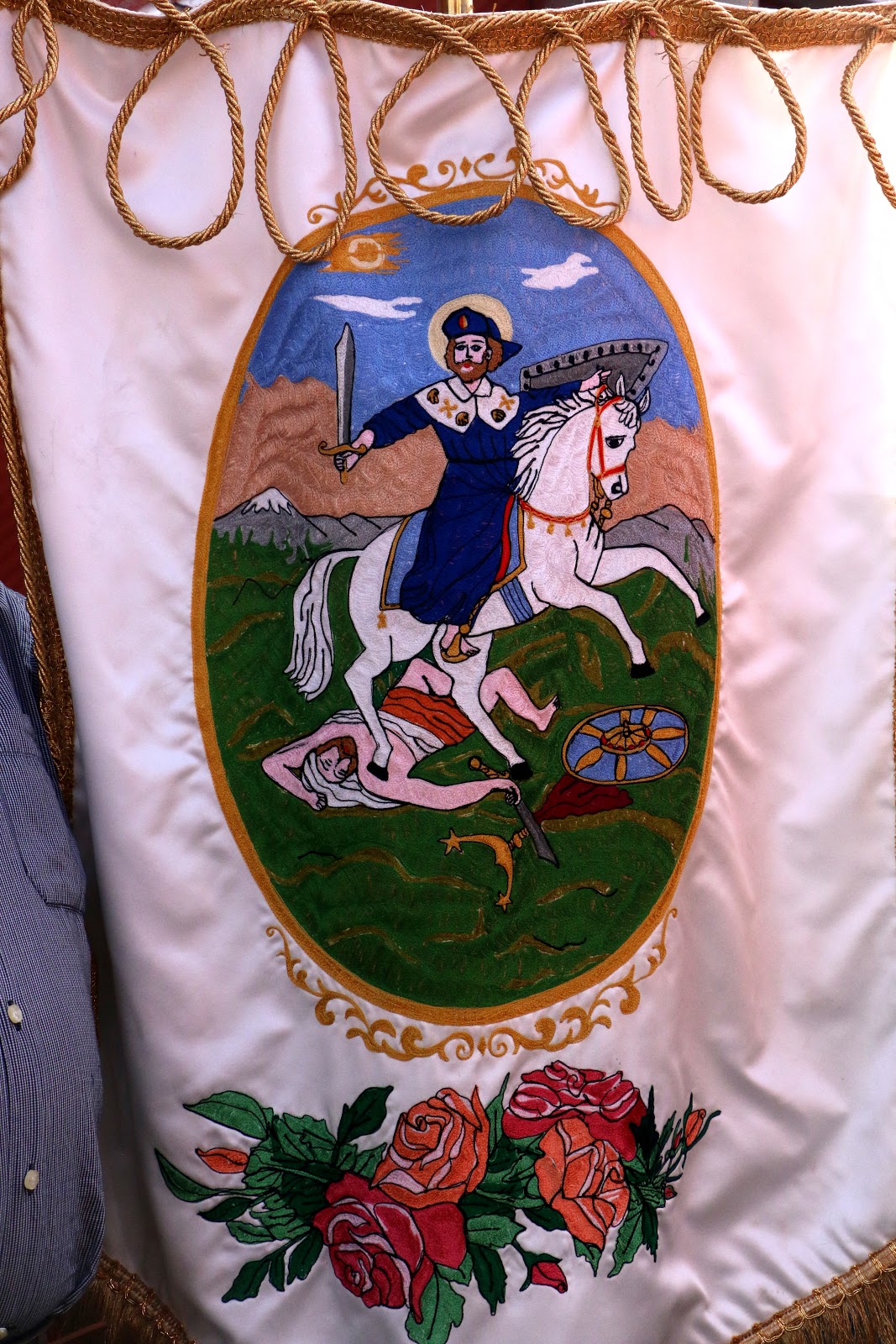 |
| Santiago Matamoros, St. James the Moor Slayer, the disciple of Jesus who, according to legend, traveled to the Roman province of Iberia to founded Christianity in the 1st century CE. According to Spanish Catholic belief, he miraculously returned 800 years later to help expel Muslims, a "reconquest" completed in 1492, thus bringing into being the full Kingdom of Spain. |
 |
| Santiago is, thus, he who defeats pagans in defense of Spanish Christianity; Hence, he became a symbol to the indigenous peoples of the New World, to convert or else... He is very popular in Mexcian Catholicism. |
 |
| Santiago Accompanied by Modern Superheroes (Our personal favorite) |
 |
| Two doncellas, maidens, precede the ultimate maiden |
 |
| The Virgin (Mary) of Candelaria, with el Niño Jesús, the Infant Jesus. Her Feast Day is February 2, forty days after Christmas. |
 |
| Even younger innocents precede another Virgin Mary |
 |
| Another Virgin of Candelaria (One or more Virgins Mary are always in a procession of saints, no matter the primary saint being honored, even when it is Her Son. |
 |
| The Virgin of Guadalupe, Mother of Mexico |
 |
| Finally, saints are also represented in paintings |
 |
| The procession returns to the atrio of the church. A celebration of the Mass will follow. |
Quema de Salva, A Salvo of Cohetes.
The procession will be followed, as they always are, by a Mass dedicated to the saint of the day, this time, the Divine Savior. But we have seen on the fiesta announcement that before the Mass there is to be a quema de salva, a long series of exploding of cohete firecrackers — a kind of military-style salute to the saint of the day. Often this is done from the roof of the church or a building attached to it.
We see no sign of anyone on the roof, so we ask one of the parishioners where it will occur, so we can find the best position for taking photos. He tells us it is about to take place in the street behind the church, so we hurry out of the atrio and around toward the rear. On the way, we pass a small plaza — the kind that is usually in front of a church atrio, so we hadn't seen it when we arrived earlier in the day. At the near side is a large, very formal metal sign providing what is evidently some historical information about Nextipac. We certainly want to learn what it has to share.
But we will have to return to read the sign later because la salva is beginning. Young men are hurrying from a building at the rear, carrying bunches of cohetes to other men in the street behind the church. There, these men are handing them one at a time to still others who light them — one after another — as fast as possible. The noise is, of course, deafening. Surely, the saints and the Trinity above hear it. The street is full of smoke.
 |
| Quema de salva |


Returning to the Foundations of Nextipac
When the quema ends, relative calm and quiet return, and the smoke begins to clear. We go back to the side of the church to explore the plaza and to read the information on the sign about the history of Nextipac.

The sign's information is in two sections. The first is headed, "Summarizing Efforts to Investigate and Conserve Your Heritage" It reads:
"In the year 2014, with the purpose of remodeling the main plaza of the pueblo of San Juanico Nextipac, researchers from the National Institute of Anthropology and History, with the support of the neighbors of Delegación Iztapalapa, carried out archaeological excavations and succeeded in recovering valuable information about Nextipac's past.
"They were able to record various structures used for habitation that date from the prehispanic epoch: stucco floors, possible remains of a platform, an offering, a fireplace and buildings of adobe (clay).
The archaeological materials recovered are of ceramic, stone, shell and bone. They take us back not only to a prehispanic occupation that goes from 900 [CE] to 1519 [year Hernán Cortés and his Spanish soldiers entered the Valley of Mexico], but also to an important occupation that continued after the Spanish conquest in 1521 until our days."The illustrations in red to the right side of this first section represent some of the objects found.
The second section is headed: "The Roots of Your Barrio: the Archaeology of San Juan Nextipac". It reads:
"Here, below this park and among ancient pipes, cables and tree roots, were found the remains of houses from the prehispanic epoch. Their location, the materials used, the used objects and objects recovered permitted the archaeologists to infer that their inhabitants were families of a high social level.
"In that epoch it was common to place buried persons as offerings below the floors of constructions. Because of this, it was not strange that during the excavations the archaeologists discovered two burials of children, each of them placed in two small, circular pits created with stucco floors.
"The remains of one infant were inside a pot covered with a top allowing the burning of incense. The other minor was placed directly in the pit in a seated position, with a pottery bowel over its skull."The illustration in red to the left of this section portrays the outline of the habitation and the location of the two circular graves below its floor.
Reading the sign standing in the little plaza of San Juanico Nextipac, we feel a sense of awe and respect, as if we are virtually standing in the pueblo of the past. We are standing where in the early 1300s the Mexica stayed for four years as they neared the end their pilgrimage to find a home of their own on another island, farther north in Lake Texcoco.
Now, from this brief but informative sign, we know that the island was inhabited at least four hundred years before the Mexica arrived and not just by simple, common people, but by people "of high social level". We deduce that they were likely from nearby Culhuacán, which had already been occupied by the Tolteca Culhuas for three hundred years prior to the building of the houses, and they dominated the area.
And as the sign says, evidence was also found of the pueblo's continuous habitation from 900 CE up to the Spanish Conquest, and on to modern times. So we wonder how descendants of the occupants of these original homes interacted with the itinerant Mexica, and again, two hundred years later, with the Spanish when they arrived.
Finally, we do know that sometime in the 16th century, the Franciscans arrived and built the first chapel where the present church sits, immediately beside the plaza, and dedicated the pueblo of Nextipac to St. John the Baptist. The congregation they established among the residents still exists and continues to celebrate its existence and identity with lively and frequent fiestas.
And somewhere nearby, below the recently renovated plaza, are the graves of two children buried over one thousand years ago,
 |
| To the left side of the church door is a stone or molded cement plaque: The glyph, as in the Nahua year count, represents a House or Clan sitting atop ashes. Nextlicpac, Over the Ashes |
 |
Delegación Iztapalapa (light green)
sits on the mid-east side of Mexico City. |
 |
| Delegación Iztapalapa, with all its pueblos (original villages) and colonias (modern developments).
San Juanico Nextipac sits in its northwest corner.
It is the very small, dark blue, narrow rectangle
just above its name (in yellow). |


