Mexico City is shaped rather like a lumpy pear. Skinny at the top, it even has a "stem", then rounds out into a very fat bottom. It is divided into sixteen delegaciones, or boroughs, of greatly varying sizes, shapes, population densities and histories.
 |
| Mexico City's sixteen delegaciones (boroughs) |
The Historic Center of the city is in the northern, skinny part, in the delegación of Cuauhtémoc. It is where the Mexica/Aztec city of Tenochtitlán was located on an island in the middle of Lake Texcoco. Other indigenous city-states or altepetls lined the lake shore, including Azcapotzalco, Tlacopan, Coyoacán, Culhuacan and Xochimilco.
 |
| Tenochtitlán, with Templo Mayor Volcanoes Iztaccíhuatl and Popocatépetl form the eastern horizon Painting in Museum of the City of Mexico |
In 1521, after Hernán Cortés and his indigenous allies defeated the Aztecs, the Spanish leveled the indigenous city and began constructing Mexico City.
 |
| "House of the Blue Tiles", in Centro Histórico. Palace built in late 1700's by the Count del Valle de Orizaba |
Although the Spanish soon began draining the lakes to reduce flooding in the summer rainy season, the city remained pretty much confined to the island until the 20th century.
The other indigenous towns were developed as separate Spanish colonial towns, where the wealthy peninsulares (born in Spain) and criollos (Spanish born in the New World) established country homes and haciendas, rather like the estates built by Boston Brahmins on Newport Island and in the Berkshires, and wealthy New Yorkers built along the Hudson.
 |
| Valley of Mexico, mid-19th century, by José María Velasco Mexico City lies in the distance, middle left. Volcanoes Iztaccíhuatl and Popocatépetl form the eastern horizon. |
In the 19th and 20th centuries, the Federal Government gradually incorporated the outlying towns and the surrounding mountains to the south and west into what was then known as the Federal District [January 2016, Mexico City officially became its own governmental entity].
During the Porfiriato, the continuous presidency of Porfirio Díaz from 1876 to 1911, stylish suburban colonias or neighborhoods of large homes, such as Santa María Ribera, San Rafael and Roma were built for the new, wealthy industrial and commercial class on drained lake bed to the west and south of the city center. After the Mexican Revolution, in the 1920's and 1930's, additional neighborhoods, like Condesa were developed. Not until after World War II did the city´s growth explode—ingesting, amoeba-like—all these outlying settlements.
Thus, contemporary Mexico City is an amalgam, a crazy quilt or a collage of barrios and colonias from many centuries and cultural epochs, with their varying architectural styles. Some, such as Azcapotzalco, Iztacalco, Iztapalapa, Coyoacán, Tlalpan, Xochimilco and Tláhuac, as indicated by their indigenous names, have historic cores going back more than seven centuries, and some buildings, often Spanish colonial churches, that go back four or five.
 |
| San Juan Bautista, St. John the Baptist church, in Coyoacán built by Franciscan monks in the 1520's. |
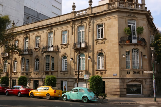
Others, including the colonias of Santa Maria Ribera, San Rafael, and Roma in Delegación Cuauhtémoc, are Parisian-style enclaves from the turn-of-the-19th to 20th century.
 |
| Palacial home in Roma Norte converted to apartments |
Yet other delegaciones, like Benito Juárez, which fills part of the old lake bed, or Miguel Hidalgo and Álvaro Obregon that expand to the northwest and southwest, are Post-War modern.
 |
| Modern home in Benito Juárez |
And in the plains and mountains to the south and west, in the delegaciones of Tlalpan, Milpa Alta, Tláhuac, Xochimilco, Magdalena Contreras and Cuajimalpa, there are pueblos (traditional villages) where nopal cactus, vegetables and flowers are grown to supply "the city", where men wear cowboy hats and ride horses, and patron saint fiestas are celebrated as they are in "las provincias" (the other states), just as they have been since Spanish Catholicism was merged with indigenous religions.
It is interesting to note the two sets of names used to identify delegaciones: nahuatl (Aztec) for those with roots in native histories, in contrast with those named after the leaders of Mexico's development as an independent nation. This distinction reflects a three-way divide between Mexico's indigenous culture, Spanish colonial culture and alternating post-Independence efforts to distance from these conflictual pasts or try to synthesize them into a national "Mexican" identity.
This struggle is embodied in the name of delegación Magdalena Contreras, located in the "rural" western mountains. Combining the Spanish name of an indigenous pueblo, Magdalena Atlitic, with Contreras, a 20th century colonia of textile mills is one divide, but the double name, Magdalena Atlitic, presents another. Throughout Nueva España, as part of their intentional acculturation of the natives, Spanish friars gave Catholic saint names to the extant indigenous villages. Most retain these double names and identities; hence, Magdalena is the Spanish name, Atlitic is the Nahua.
Mexico City Ambles is a record of paseos, leisurely walks, spent exploring some of the colonias in this urban-rural, multi-cultural collage.


No comments:
Post a Comment