The huge volcanoes of Popocatéptl, Iztaccíhuatl and Ajusco, and the other volcanoes of the Cordillera de Chichinautzin dominate the Valley and the interest of residents and visitors. We wrote about them in our first post on the many volcanoes of the Valley of Mexico, Giants on All Sides.
There are, however, other volcanoes within the current city limits. They are small ash cone volcanoes, but despite their diminutive size, at least four of them have played prominent roles in the development of human settlements in the Valley and in the history of Mexico City.
Cuicuilco, now an archeological site in the south of Delegación Tlalpan, just south of the modern campus of the University City of the National Autonomous University of Mexico (UNAM), was established around 1200 BCE. By the year 800 BCE, Cuilcuilco was a prosperous civic-ceremonial center, the first such urban center in the Valley of Mexico.
But sometime around 150-200 CE, Xitle, a small ash cone volcano near the slopes of Ajusco, erupted, and Cuicuilco was completely buried by the resulting flow of ash and lava. (See our spouse's post: Cuicuilco, Volcanoes and the Fragility of Life in Mesoamerica.)
From our balcony in Colonia Parque San Andrés, in Delegación Coyoacán, we can see a wooded hill, a little less than four miles away to the East. This hill, over which easterly summer storms arrive, is an extinct ash cone volcano called Cerro de la Estrella, Hill of the Star. It sits in what is now Delegación Iztapalapa.
The first settlements around the base of the extinct volcano date from 500 BCE. At some time around 150 CE, an influx of people arrived fleeing the Xitle eruptions on the southwest side of Lake Texcoco that buried Cuicuilco.
When the Mexicas of Tenochtitlán took the peninsula, they rebuilt the temple on the summit of what they called Huizachtecatl and made it the site of one of their most important rituals, xiuhmolpilli (sheeoo-mol-PEEL-yee), the Binding of the Years. In Spanish it is called Nuevo Fuego, the New Fire. (See our post: Cerro de la Estrella and the Origins of Culhuacán and Iztapalapa.)
Southeast of la Estrella is a chain of ash cone volcanoes called la Sierra de Santa Catarina. Although they are now totally surrounded by the urban development of Delegaciones Iztapalapa, to the north, and Tláhuac, to the south, they have been emblematic over the centuries in images of the Valley of Mexico.
Mexico City is shaped rather like a lumpy pear (see map above). At its wide bottom are the largest delegaciones of Tlalpan and Milpa Alta, which contain the large volcanoes of la Sierra de Chichinautzin. In the pear's narrow neck sits the City's Centro Histórico, now in Delegación Cuauhtémoc. At the top is the "stem", which is the northern end of Delegacion Gustavo Madero. This "stem" is so narrow because it is bounded by another set of hills, la Sierra de Guadalupe.
Like la Sierra de Santa Catarina, la Sierra de Guadalupe is composed of a chain of cinder cone volcanoes that originally extended south as a peninsula into Lake Texcoco. At the tip of that peninsula was a hill known as Tepeyac.
The Hill of Tepeyac is one of the most famous of hills in all of Christendom, certainly in the Roman Catholic world. It is here that, according to legend, in December of 1531, the Virgin of Guadalupe appeared several times to the indigenous peasant, now saint, Juan Diego Cuauhtlatoatzin. She told him that she was personally adopting the people of Nueva España as her own and directed him to go to the bishop of Mexico City to request that a chapel be built for her on the site, previously the site of an indigenous temple to the mother goddess, Tonantzin. From this sacred place, the Virgin promised that she would look after her pueblo (people).
The first, temporary chapel built for her was replaced a number of times over the centuries by larger churches. The last two were given the status of basilicas (churches of special importance) by the Pope. Over time, a complex of additional churches was built around the base of Tepeyac and on its summit. The Basilica is the most visited Catholic pilgrimage site in the world, and one of the world's most-visited sacred sites of any religion. (Wikipedia. See our post: Tepeyac and the Virgin of Guadalupe)
Chapúltepec Hill, Hill of the Grasshopper, is a small cinder cone volcano that originally sat near the West shore of Lake Texcoco. Freshwater springs arose from its base, making it valuable for human settlements. It was a sacred site for the indigenous peoples who lived in the area before the arrival of the Mexicas in the Valley of Anahuac in 1225 CE. In their search for a place to settle in the Valley, the Mexica were able to live on Chapultepec from 1279 to 1299, when they were attacked by other altepetls (city-states) and forced to move on further south along Lake Texococo.
Two hundred years later, after the Mexicas defeated the Tepanecas of the altepetl Azcapotzalco, located just north of Chapúltepec, they took over Chapúltepec and made it into a private reserve for royalty. They built baths and an aqueduct to carry spring water to their island city of Tenochtitlán. When the Spanish defeated the Mexicas, they rebuilt the aqueduct and continued its use as a preserve for the ruling class.
In 1775, the Spanish Viceroy, Bernardo de Gálvez, ordered the construction of a stately home for himself on top of Chapúltepec Hill. Construction began the same year. However, in November 1786, the viceroy died suddenly, and the Spanish Crown ordered the building to be auctioned. For twenty years there were no buyers. In 1806, the building was finally bought by Mexico City's municipal government. However, it remained empty throughout the War for Independence (1810-21) and the early years of Mexico's new government.
Xitle now lies within El parque ecológico de la ciudad de México, The Ecological Park of the City of Mexico, in Delegación Tlalpan. Cuicuilco, the city buried by Xitle, is an archeological park, also in Tlalpan. Both are reachable only by car.
Cerro de la Estrella is within a park in Delegacion Iztapalapa. You can take Metro line 8 (green line) to the Iztapalapa station and get a taxi from there or take a taxi from other parts of the City. Part way up the hill is the Museo del Nuevo Fuego, Museum of the New Fire. It is small but with excellent exhibits explaining the ritual of the Binding of the Years and its significance. From there, you can walk up a roadway, through the park to the base of the summit. There you climb stairs to the temple at the top. On a clear day, you have a view of the entire Valley of Mexico, including the big volcanoes of Popocatépetl, Iztaccíhuatl and Ajusco. You also get a good view of the nearby Sierra de Santa Catarina.
The Hill of Tepeyac is easy to visit. La Villa Basílica is a station on Line 6 (red) of the Metro. Depending on where you start, you will have to make some changes between Metro lines. The hill is, of course, within the Villa Guadalupe, the complex of churches associated with the Basilica of the Virgin of Guadalupe in Delegación Gustavo Madero. The Hill, itself, has been transformed into a beautiful garden with flowering trees, roses and a waterfall. At the top is the Chapel of the Hill.
There are, however, other volcanoes within the current city limits. They are small ash cone volcanoes, but despite their diminutive size, at least four of them have played prominent roles in the development of human settlements in the Valley and in the history of Mexico City.
Xitle, a small volcano that buried a city
Cuicuilco, now an archeological site in the south of Delegación Tlalpan, just south of the modern campus of the University City of the National Autonomous University of Mexico (UNAM), was established around 1200 BCE. By the year 800 BCE, Cuilcuilco was a prosperous civic-ceremonial center, the first such urban center in the Valley of Mexico.
But sometime around 150-200 CE, Xitle, a small ash cone volcano near the slopes of Ajusco, erupted, and Cuicuilco was completely buried by the resulting flow of ash and lava. (See our spouse's post: Cuicuilco, Volcanoes and the Fragility of Life in Mesoamerica.)
 |
| Xitle is the now innocent appearing, forested low hill to the left, below Ajusco. |
 |
| Xitle, with some of its lava flow. The City of Mexico invades, building on the Pedregal, "stony ground" of lava. Ajusco rises in the background. |
 |
| Circular 'pyramid' of Cuicuilco. Note the depth of the surrounding excavation trench below the current ground level; It is all lava that buried the city when Xitle erupted |
Cerro de la Estrella , Hill of the Star: Sacred and Strategic Center in Indigenous History
From our balcony in Colonia Parque San Andrés, in Delegación Coyoacán, we can see a wooded hill, a little less than four miles away to the East. This hill, over which easterly summer storms arrive, is an extinct ash cone volcano called Cerro de la Estrella, Hill of the Star. It sits in what is now Delegación Iztapalapa.
If you look carefully, with the help of binoculars or a telephoto lens, at the north end (to the left) of the fairly flat summit, you can see a large white cross and a flat structure behind it. Both have stories to tell.
 |
Cerro de la Estrella, Hill of the Star
It was called Huizachtecatl (Náhuatl) by the Mexicas Telephoto from the roof of our apartment building. |
The cross obviously has to do with a Christian narrative. (See: Iztapalapa's Holy Week Passion Play). The flat structure is a temple. The temple, in its final form, was built by the Mexicas (Aztecs) of Tenochtitlán, after they took over the surrounding area in 1430 BCE.
The temple had existed there, however, since the end of the first millennium of the Common Era. It was built by the Toltec residents of the town of Culhuacán (also spelled Colhuacán, "place of the Culhua"—"the ancient or venerable ones"). Coming from the Toltec city of Tula, north of the Valley of Mexico, they settled on the south side of the hill around 600 CE.
The temple had existed there, however, since the end of the first millennium of the Common Era. It was built by the Toltec residents of the town of Culhuacán (also spelled Colhuacán, "place of the Culhua"—"the ancient or venerable ones"). Coming from the Toltec city of Tula, north of the Valley of Mexico, they settled on the south side of the hill around 600 CE.
 |
| Temple on the summit of Cerro de la Estrella |
The first settlements around the base of the extinct volcano date from 500 BCE. At some time around 150 CE, an influx of people arrived fleeing the Xitle eruptions on the southwest side of Lake Texcoco that buried Cuicuilco.
When the Mexicas of Tenochtitlán took the peninsula, they rebuilt the temple on the summit of what they called Huizachtecatl and made it the site of one of their most important rituals, xiuhmolpilli (sheeoo-mol-PEEL-yee), the Binding of the Years. In Spanish it is called Nuevo Fuego, the New Fire. (See our post: Cerro de la Estrella and the Origins of Culhuacán and Iztapalapa.)
La Sierra de Santa Catarina
Southeast of la Estrella is a chain of ash cone volcanoes called la Sierra de Santa Catarina. Although they are now totally surrounded by the urban development of Delegaciones Iztapalapa, to the north, and Tláhuac, to the south, they have been emblematic over the centuries in images of the Valley of Mexico.
 |
| Sierra de Santa Catarina runs southeast of Cerro de la Estrella |
 |
Tecuauhtzin and Guadalupe,
the two volcanoes at the east end of la Sierra Santa Catarina
that forms the boundary between Delegaciones Iztapalapa and Tlahuac.
|
 |
| The Valley of Mexico by José María Velasco Wikipedia In front of snow-capped Iztac and Popo lies the Sierra de Santa Catarina |
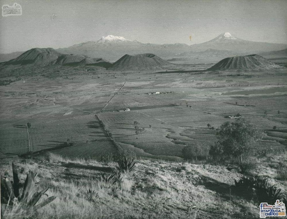 |
| Sierra de Santa Catarina in the 1920s. Iztaccihuatl and Popocatepetl are in the background. From Facebook: Cronista de Nuestra Antiguo Iztapaluca-Chalco |
 |
| Mexico City and Its Many Volcanoes. (Mexico City's boundaries and sixteen component delegaciones are outlined in white.) The "stepping stone-like row of islands" across what was once lake bed (taupe) are: Cerro de la Estrella (alone, in dead-center of the map) and la Sierra de Santa Catarina (the middle "island", right-center). Actually, they were on the Iztapalapa peninsula separating Lake Texcoco to the north from Lake Xochimilco to the south. The biggest "stepping stone," to the east, outside City limits is Volcán Pino, the Pine, in the State of Mexico. |
Hill of Tepeyac
 |
| La Sierra de Guadalupe. The tallest, and most northern hill is Zacateco (2,475 meters, 8,120 ft.) (white line shows the boundary between Mexico City and the State of Mexico.) The group of small hills to the south are called Los Gachupines (a derogatory word used by natives in Colonial New Spain for the Spanish). At the southern end of these is the Hill of Tepeyac, at the base of which sits the Basilica of the Virgin of Guadalupe. |
Like la Sierra de Santa Catarina, la Sierra de Guadalupe is composed of a chain of cinder cone volcanoes that originally extended south as a peninsula into Lake Texcoco. At the tip of that peninsula was a hill known as Tepeyac.
The Hill of Tepeyac is one of the most famous of hills in all of Christendom, certainly in the Roman Catholic world. It is here that, according to legend, in December of 1531, the Virgin of Guadalupe appeared several times to the indigenous peasant, now saint, Juan Diego Cuauhtlatoatzin. She told him that she was personally adopting the people of Nueva España as her own and directed him to go to the bishop of Mexico City to request that a chapel be built for her on the site, previously the site of an indigenous temple to the mother goddess, Tonantzin. From this sacred place, the Virgin promised that she would look after her pueblo (people).
The first, temporary chapel built for her was replaced a number of times over the centuries by larger churches. The last two were given the status of basilicas (churches of special importance) by the Pope. Over time, a complex of additional churches was built around the base of Tepeyac and on its summit. The Basilica is the most visited Catholic pilgrimage site in the world, and one of the world's most-visited sacred sites of any religion. (Wikipedia. See our post: Tepeyac and the Virgin of Guadalupe)
 |
| Hill of Tepeyac Chapel of the Hill is at the top. |
Chapúltepec Hill, Hill of the Grasshopper
Chapúltepec Hill, Hill of the Grasshopper, is a small cinder cone volcano that originally sat near the West shore of Lake Texcoco. Freshwater springs arose from its base, making it valuable for human settlements. It was a sacred site for the indigenous peoples who lived in the area before the arrival of the Mexicas in the Valley of Anahuac in 1225 CE. In their search for a place to settle in the Valley, the Mexica were able to live on Chapultepec from 1279 to 1299, when they were attacked by other altepetls (city-states) and forced to move on further south along Lake Texococo.
 |
| The glyph identifies Chapultepec Hill (Hill of the Grasshopper) The glyphs at the top name the years 13 House, 1 Rabbit and 2 Reed, (1297, 1298 and 1299 CE) The attack on the Mexica occurred in 2 Reed, 1299.From Codex Aubin written by a Mexica in the mid 16th century, at the request of Spanish monks, it presents the history of the Azteca/Mexica from their migration out of their legendary home of Aztlan in the year 1 Flint, (1168 CE) through the foundation of Tenochtitlan in 1325, to the cataclysmic events of the Spanish conquest in 1521. (Wikipedia) (Photograph and translation of Nahuatl from Fordham University) |
Two hundred years later, after the Mexicas defeated the Tepanecas of the altepetl Azcapotzalco, located just north of Chapúltepec, they took over Chapúltepec and made it into a private reserve for royalty. They built baths and an aqueduct to carry spring water to their island city of Tenochtitlán. When the Spanish defeated the Mexicas, they rebuilt the aqueduct and continued its use as a preserve for the ruling class.
In 1775, the Spanish Viceroy, Bernardo de Gálvez, ordered the construction of a stately home for himself on top of Chapúltepec Hill. Construction began the same year. However, in November 1786, the viceroy died suddenly, and the Spanish Crown ordered the building to be auctioned. For twenty years there were no buyers. In 1806, the building was finally bought by Mexico City's municipal government. However, it remained empty throughout the War for Independence (1810-21) and the early years of Mexico's new government.
Sometime between 1833 and 1840 (different sources give different dates), the Military Academy, founded in 1823, was moved to the Castle. This move set the stage for the Castle's major role in Mexican history.
In May 1846, the United States declared war against Mexico, based on an armed conflict it had provoked along the Rio Grande River. The river was the disputed border with Mexico after the secession of Texas from Mexico in 1836 and its entrance into the Union as a state in 1845. President James Polk, who took office in March 1845, wanted Mexican territory west of what had been the Louisiana Purchase, all the way to California, to gain U.S. access to the Pacific Ocean. He offered to buy it from Mexico. When Mexico refused to sell it, Polk sent troops into the disputed territory along the Rio Grande. When Mexican forces attacked those troops, Polk obtained a declaration of war from Congress.
As part of a three-pronged strategy, U.S. troops invaded Mexico from Texas, went west into Nueva México and Alta California, and, in March 1847, undertook an amphibious attack on the port of Veracruz in the Gulf of Mexico. Led by Gen. Winfred Scott, U.S. marines and army seized the port city and marched inland toward Mexico City.
After a series of battles, U.S. troops arrived at the doorstep of the capital in August. On Sept. 12, 1847, the final battle was fought at Chapúltepec Castle. There, young Mexican Army cadets fought to the last man. Five of them, los Niños Heroes, the Boy Heroes, are honored for their sacrifice by a large monument at the base of Chapúltepec Hill.
While they lack the geologic awesomeness of the big volcanoes ringing the Valley of Mexico, the small volcanoes within the city make up for their size via their impact on human history in the Valley. They are also relatively easy to visit.
 |
| Chapúltepec Castle sits on Chapúltepec (Grasshopper) Hill above the Monument to the Niños Héroes, the Boy Heroes, military cadets who fought to their deaths against U.S. forces taking Mexico City in the Mexican-American War in 1847. |
In May 1846, the United States declared war against Mexico, based on an armed conflict it had provoked along the Rio Grande River. The river was the disputed border with Mexico after the secession of Texas from Mexico in 1836 and its entrance into the Union as a state in 1845. President James Polk, who took office in March 1845, wanted Mexican territory west of what had been the Louisiana Purchase, all the way to California, to gain U.S. access to the Pacific Ocean. He offered to buy it from Mexico. When Mexico refused to sell it, Polk sent troops into the disputed territory along the Rio Grande. When Mexican forces attacked those troops, Polk obtained a declaration of war from Congress.
As part of a three-pronged strategy, U.S. troops invaded Mexico from Texas, went west into Nueva México and Alta California, and, in March 1847, undertook an amphibious attack on the port of Veracruz in the Gulf of Mexico. Led by Gen. Winfred Scott, U.S. marines and army seized the port city and marched inland toward Mexico City.
After a series of battles, U.S. troops arrived at the doorstep of the capital in August. On Sept. 12, 1847, the final battle was fought at Chapúltepec Castle. There, young Mexican Army cadets fought to the last man. Five of them, los Niños Heroes, the Boy Heroes, are honored for their sacrifice by a large monument at the base of Chapúltepec Hill.
Encountering the Small but Mighty Volcanoes
While they lack the geologic awesomeness of the big volcanoes ringing the Valley of Mexico, the small volcanoes within the city make up for their size via their impact on human history in the Valley. They are also relatively easy to visit.
Xitle and Cuicuilco
Xitle now lies within El parque ecológico de la ciudad de México, The Ecological Park of the City of Mexico, in Delegación Tlalpan. Cuicuilco, the city buried by Xitle, is an archeological park, also in Tlalpan. Both are reachable only by car.
Cerro de la Estrella
Cerro de la Estrella is within a park in Delegacion Iztapalapa. You can take Metro line 8 (green line) to the Iztapalapa station and get a taxi from there or take a taxi from other parts of the City. Part way up the hill is the Museo del Nuevo Fuego, Museum of the New Fire. It is small but with excellent exhibits explaining the ritual of the Binding of the Years and its significance. From there, you can walk up a roadway, through the park to the base of the summit. There you climb stairs to the temple at the top. On a clear day, you have a view of the entire Valley of Mexico, including the big volcanoes of Popocatépetl, Iztaccíhuatl and Ajusco. You also get a good view of the nearby Sierra de Santa Catarina.
Hill of Tepeyac
The Hill of Tepeyac is easy to visit. La Villa Basílica is a station on Line 6 (red) of the Metro. Depending on where you start, you will have to make some changes between Metro lines. The hill is, of course, within the Villa Guadalupe, the complex of churches associated with the Basilica of the Virgin of Guadalupe in Delegación Gustavo Madero. The Hill, itself, has been transformed into a beautiful garden with flowering trees, roses and a waterfall. At the top is the Chapel of the Hill.
Chapúltepec Hill
Chapúltepec Hill is near the main entrance to Chapúltepec Woods, down the Paseo de la Reforma from Centro Histórico. The main walkway from the Chapúltepec Metro Station on Line 1 (pink) leads directly to the Monument to the Boy Heroes. From there, you can walk up a wide roadway or take a tram to the top of the hill.
The Castle now contains the National Museum of Mexican History. Exhibits include original portraits of many of the Spanish viceroys, rooms as they were decorated by Emperor Maximillian I, and the dramatically contrasting carriages of Maximillian (ornate) and President Bentio Juárez (simple), who defeated him. There are also stunning murals by David Siqueiros portraying aspects of the Mexican Revolution. We think they are the best work by Siqueiros in the City. There is also a wonderful roof garden and a large porch where, on clear days, visitors can get a great view of Paseo de la Reforma and Mexico City.
See also: Encountering Mexico City's Many Volcanoes, Part I: Giants on All Sides
See also: Encountering Mexico City's Many Volcanoes, Part I: Giants on All Sides


