Showing posts with label Carmelites. Show all posts

Saturday, January 7, 2017

Lions in the Desert: The Carmelite Order, The Conquest of the Spirit & The Spiritual Conquest

As we wrote when we began our explorations of the Original Villages of Mexico City, after Cortés, with his Spanish soldiers and indigenous allies, had conquered Tenochtitlan, he had not only to transform that city, he also had to transform a geographically extensive civilization and culture that filled the Valley of Anahuac (now the Valley of Mexico) and stretched far beyond. This meant implementing a program of radical reconstruction of the culture, of the peoples' customary ways of being and their organizing beliefs. It required the "conversion" of el pueblo, the people, to Spanish Catholicism. This was the "Spiritual Conquest".

Carmelites in Mexico City

To accomplish this huge task, Cortés first relied on Franciscan monks. They were soon joined by Domincans, Augustinans and members of other religious orders. Among the later arrivals were the Discalced or Barefoot Carmelites.

We have visited and written about the Carmelites' first convent, the Convent and Church of San Ángel, begun in 1597 and now located in the colonia of the same name in Delegación Álvaro Obregón. We have also visited their Church and Convent of San Joaquín, now in Delegación Miguel Hidalgo, built a hundred years later, in 1689, more modest in size than San Ángel but remarkable for its medieval architectural simplicity.

A third Carmelite convent still stands within Mexico City. But, unlike San Ángel and San Joaquín, it does not sit in the midst of urban modernity and congestion. Instead, it sits in a "desert". But this "desert" is not arid and barren. It is a lush, shady forest of towering conifers in mountains that rise as high as as 3,800 meters, 12,400 feet in altitude, 5,000 feet above the Valley, on the west side of the city, in the Delegación Cuajimalpa. Comprising some 4,600 acres, it is now a national park, Desierto de los Leones, Desert of the Lions.

Convent in the Desert of the Lions


 Desierto de los Leones

Convento del Desierto de Nuestra Señora del Carmen de los Montes de Santa Fe, Convent of the Desert of Our Lady of Carmen of the Mountains of the Holy Faith is now officially called Ex-Convento del Desierto de los Leones, Ex-convent of the Desert of the Lions. Built by the Carmelites shortly after San Ángel, at the beginning of the 17th century, it sits at an altitude of 9,700 feet, nearly 3,000 feet above the Valley floor.

As for why the forest came to be called Desierto de los Leones, there are two stories, one romantic, the other pragmatic. The first is that there were mountain lions in the woods, making it a place of risk. The other is that a Spanish family named León had been granted the land by the king, and they donated it to the Carmelites, perhaps to gain holy indulgences for their sins and thus save themselves from having to pay for them after death with time in Purgatory.  

Convento del Desierto de Nuestra Señora del Carmen
de los Montes de Santa Fe

What does it mean that this Carmelite convent in an evergreen forest is "in the desert". And why was it built so far from the colonial city that sat in the middle of Lake Texcoco and the original indigenous villages that surrrounded the Lakes? Those villages were the objects of the Spiritual Conquest, the work, the vocation, of the religious orders, including the Carmelites. San Ángel and San Joaquín were established in two key villages, Tenanitla and Tlacopan on the west shore of the Lake, in order to carry out the conversion of los indios.

The convent still remains quite apart from the vastly larger modern city that now occupies the entire Valley floor and is determinedly climbing the mountain slopes. Reachable only by car along one of two narrow roads winding up the mountains, it still sits in the midst of a tranquil world far apart from the bullicio, hubbub, of contemporary Mexico City.

Answering these questions requires us to go back in time three hundred years before the Carmelites arrived in Nueva España and from Spain to the other end of the Mediterranean, to the time of the Crusades and the Holy Land.

The Carmelites: From the Prophet Elijah to the Holy Land Crusades to Nueva España

The Carmelite religious order originated in the early 13th century, during the era of the Crusades (11th to 13th centuries). The Order was formed by lay European pilgrims on Mt. Carmel in the Holy Land. They chose Mount Carmel because it was the site of various miraculous acts of the prophet Elijah. Carmelite tradition holds that a community of Jewish hermits continued to live at the site from the time of Elijah (9th century BCE) until the founding of their order there 2,000 years later. There are historical records of a group of ascetic Essenes living on the mountain in the second and first centuries BCE.

Carmelite monks followed this ascetic tradition, leading strict, self-disciplined lives as recluses, hermits, their lives devoted to solitary prayer, perpetual silence and penitential mortification of the body to overcome temptation to sin and develop a humility of spirit.
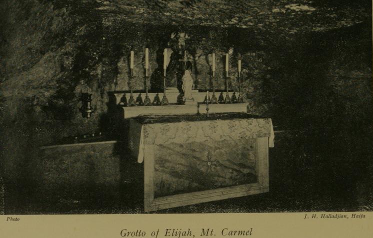
Grotto of Elijah, on
Mount Carmel in the Holy Land
Wikipedia

In the latter part of the 13th century, members of the order were forced to returned to Europe because of numeous conflicts between Crusader States that had been created in the eastern Mediterranean and resurgent Muslim forces that culminated in the formation of the Ottoman Empire at the end of that century.

Over the next three hundred years, a combination of the prevailing political and social conditions in Europe—the Hundred Years' War and the Black Plague, with their untold numbers of deaths and economic devastation, and the rise of the Renaissance and Humanism—adversely affected the Order. There was a general decline in religious fervor. The strict ascetic Rule governing the order was "mitigated" several times. Consequently, the Carmelites bore less and less resemblance to the first hermits of Mount Carmel.

Counter-Reformation and Carmelite Renewal 


In the 1500s, the Roman Catholic Church was challenged by the Protestant Reformation. As part of the Counter-Reformation there were many initiatives to purify and renew the Catholic Church. Among those feeling the call to reform and renewal was a Spanish nun, later to become St. Teresa of Ávila, who sought to return the Carmelites to their Primitive Rule. In 1562, with a group of fellow nuns, she established a small convent in the city of Ávila, Spain. The Rule of the order contained exacting prescriptions for a life of continual prayer, with strict enclosure within the convent, sustained by the asceticism of solitude, manual labor, perpetual abstinence, fasting and charity.

A monk, who was to become St. John of the Cross, established the first men's convent of Discalced Carmelite friars in Duruelo, Spain in 1568. Nearly thirty years later, in 1597, members of the order arrived in Nueva España and began construction of their first convent, San Ángel.

Zurbarán St. John of the Cross.jpg
St. John of the Cross,
Founder of the Discalced Carmelites

Painting by Francisco Zubarán, 1656
Wikipedia

Convent in a Desert of Mountains

Just ten years later, the Carmelites began construction of their convent "in the desert". While the mountains around the Valley of Mexico were an environment radically different from Mt. Carmel in the Holy Land, they provided the characteristic of a desert essential to the Carmelite discipline. As a wilderness set apart from human community, they provided the isolation essential to an eremitical life of solitude and prayer, "far from the madding crowd's ignoble strife" (Elegy Written in a Country Churchyard, Thomas Gray).

While the mission of the Carmelites in the New World of Nueva España, like that of all the other religious orders, was the conversion and education of los indios, which was an intensely communal and interactive process, the Convent of the Desert gave them a retreat from that world where they could return to and be nourished by the roots of their four-hundred-year-old spiritual heritage and practice. It made possible the combination of fullfilling a vocation in the world of people and eremitical withdrawal to solitude, silence and self-purification.

Gated path leads through the forest
to a chapel for prayer

Chapel of the Secrets
Monks could pray aloud together here, 

but had to face the walls to avoid eye contact.

Construction of the convent began in January of 1606. It was designed by Friar Andrés de San Miguel, who also designed the Convent of San Ángel, and whose own interesting story of salvation from a ship wreak we came upon in our research on that convent. By 1722, because of the wet climate of the mountains, the original Desierto convent had greatly deteriorated, so it was demolished and a new convent, the one still standing, was built in its place.

Only four monks lived in the Convent year-round. Other brothers would come from San Ángel, and other convents the order built throughout Nueva España and spend time in spiritual retreat. Over time, a dozen hemitages, small, single-room quarters, were built in the woods around the grounds to which monks could retreat for fasting, solitary prayer and meditation. These were used primarily during the holy seasons of Advent and Lent, forty-day periods modeled on Jesus' forty days in the wilderness before he began his preaching mission.

Gateway to a hermitage

Hospedería patio
Guests' patio
Rooms around the patio were for secular guests, well-to-do Spanish men.
They were not allowed to enter the convent proper.
No women were allowed.
Neither were indios, indigenous, or mestizos, mixed-blood persons.

Convent garden,
where vegetables and fruits would have been grown.

Convent garden

Modern-day Urban Retreat

Some time after Independence from Spain was won in 1821, the convent was abandoned. In 1876, the forest around it was declared the first forest preserve in Mexico, primarily to protect the springs and streams that provide drinking water to Mexico City. In 1917, at the end of the Mexican Revolution, President Venustiano Carranza declared it the first National Park. 

The Desert of the Lions is no longer a retreat for ascetic religious self-discipline. But it does provide secular respite for city residents and other Mexicans, with hiking and biking trails and cool, shady, quiet places to relax. Restaurantes campestres, open-air restaurants, provide traditional Mexican meals under the towering, cathedral-like evergreen trees. There are also tables and barbecue pits for family picnics.

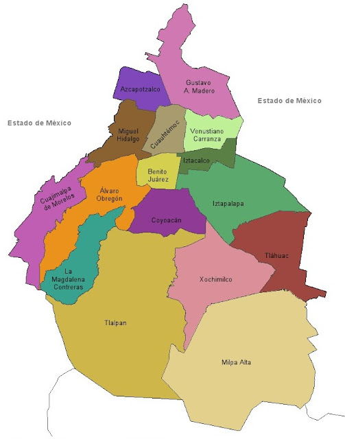


Cuajimalpa
is the long, narrow, magenta-colored delegación
on the west side of Mexico City

Cuajilmapa
Ex-Convento Desierto de los Leones
is in the dark green, forested area
of the National Park Desierto de los Leones
Two narrow roads (white lines)
wind from lower urban areas to the Convent


Friday, December 23, 2016

Mexico City's Original Villages | Miguel Hidalgo: Tacuba and The Roadway Where History Took a Fateful Turn

The Historic Roadway from Tenochtitlán to Tacuba


We began our series of ambles seeking out the Landmarks of the Spiritual Conquest, which identify the original indigenous villages from which Spanish Mexico City arose, by exploring what were the Four Original Indigenous Quarters of Tenochtitlán, now Centro. Cortés assigned them to his indigenous allies who had made the conquest of Tenochtitlán possible. Together, these four quarters were called San Juan Tenochtitlán.

When we explored the northwest quarter, Santa María Cuepopan, we discovered that the Church of San Hipólito stands at a most significant place in the history of the tumultuous change of Tenochtitlán to la Ciudad de México. It was here that Cortés and his men, attempting to flee Tenochtitlán on the night of June 30, 1520, were confronted by Mexica [meh-SHE-kuh] warriors.

San Hipólito sits at the intersection of Avenida Hidalgo,
which, to the west, becomes the Calzada México-Tacuba,
Ave. Balderas, which marks the western boundary of former Tenochtitlán,
and Paseo de la Reforma.


Night of Sorrows


On May 20, while Cortés was in Veracruz on the Gulf Coast, the Spanish had massacred Mexica priests at the Templo Mayor, then on June 26, the huey tlatoani (head speaker) Moctezuma Xocoyotzin (Moctezuma the Younger) had been killed in a confrontation between his Spanish captors and his own people. Cortés and his men were surrounded in the royal palace. In the dark of the night of June 30, they attempted to sneak out of the city.

Not surprisingly, they were caught in the act. Mexica warriors confronted them at the point where the roadway from Tenochtitlan to the important atepetl, city-state, of Tlacopan, on the west shore of Lake Texcoco, reached a moveable bridge and entered the causeway across the lake.

The Night of Sorrows - Library of Congress; Artist Unknown
Noche Triste, Night of Sorrows,
Artist unknown

Noche Triste
José Clemente Orozco

Tlacopan (now Tacuba)
was located on the west side of Lake Texcoco.
At the time of the arrival of the Mexicas in the Valley of Anahuac,
it was under the rule of A(t)zcapotzalco, just to their north.

On that fateful night, Cortés and his surviving troops, with the help of indigenous allies, managed to reach the western shore. It is legend that Cortés then collapsed beneath an ahuehuete tree and wept over his lost men. Ahuehuete means "old man of the waters" in Nahuatl. The trees, sacred to the indigenous, now carry the name Montezuma cypress.

All that remains of the trunk of the ahuehuete tree,
below which Cortés is said to have wept on the Noche Triste,
June 30-July 1, 1520.
The tree remained alive until the early 20th century.
Another Montezuma cypress,
planted some years ago, rises behind it.


The tree sits in a small plaza,

alongside the Calzada México-Tacuba,
about half way between Metro Stations Popotla and Cuitláhuac

Noche Triste
Cortés and his troops rest
on the lake shore at Tlacopan
José Clemente Orozco

Today that causeway is a major avenue, bearing several names as it extends west. Just west of San Hipólito, it is called Puente de Alvarado, Alvarado's Bridge, named after a lieutenant of Cortés who was thought to have been lost at the bridge. Subsequently, he made it to Tlacopan. The primary name of the street is the Calzada (literally, "footpath") México-TacubaLine 2, the Blue Line, of the Metro follows this ancient roadway from the Zócalo to Tacuba and beyond. So you can get there in about 15 minutes, for 5 pesos, US $0.25.

Tlacopan


The name of Tlacopan (place of the jarilla plant—same family as papaya) was converted by the Spanish into Tacuba. It is now a colonia in Delegación Miguel Hidalgo. When Cortés arrived in the Valley of Anahuac in 1519, its people were Nahuatl speaking Tepaneca. A hundred years earlier, it had been under the rule of the Tepanec atepetl of Azcapotzalco, just to its north.

However, in 1428, when the ruler of Azcapotzalco died and a power struggle erupted between possible replacements, Tenochtitlán and Texcoco, an atepetl on the east side of the Lake, decided it was their opportunity to ally against the city that dominated them. Tlacopan joined them against its overlords, thus becoming the third member of the Triple Alliance, which was to rule what is now Central Mexico for nearly one hundred years, until the arrival of the Spanish in 1519.

Tlacopan's importance led the Mexica to construct the causeway over the lake linking it with Tenochtitlán.  When Cortés and his surviving soldiers arrived via that causway to Tlacopan on July 1, 1520, in flight from Tenochtitlán, the rulers of Tlacopan rather than siding with their Mexica allies, chose instead to give shelter to the Spanish. They thereby opened the way for Cortés' retreat around the north end of the lakes and his return to Tlaxcala, the home of his major indigenous ally, over the mountains, east of the Valley.

There, Cortés was able to restore his troops and plan his ultimate attack on Tenochtitlán in the spring and summer of 1521. After the Spanish defeat of the Mexica in August of that year, Cortés granted Tlacopan/Tacuba to Isabel Moctezuma, a daughter of Moctezuma Xocoyotzin. In the first decades of the Colonial period, the village continued to be governed, for local purposes, by indigenous nobles, to whom Spanish names were given upon their baptism. One was Don Diego Cortés Chimalpopoca; another was Don Antonio Cortés Totoquihuaztli. The conqueror certainly left his mark.

Cortés. his soldiers and indigenous allies
defeat the Mexica of Tenochtitlan

Church of San Gabriel the Archangel


As they did in other cities and villages around the lakes of the Valley, the Franciscans came to Tlaopan, which they called Tacuba, built a mission church and dedicated it to the Archangel Gabriel who had announced to the Virgin Mary her pregnancy with the Son of God. The church was consecrated in 1566. In 1570, a convent or monastery was built and occupied by four friars, charged with converting and educating the people.

Church of San Gabriel Archangel, Tacuba

The site was within the prior sacred precinct of Tlacopan. The indigenous teocalli, house of god, was located on a low hill to the west of where the church was erected. In addition to stone quarried nearby, stones from the teocalli were used in building the church,

It served some fifteen settlements in the area. Like other convents, it had an orchard where figs, grapes, pears, apples, peaches, apricots and nuts were grown. It was significantly remodeled in the mid-18th century when the Archbishop of México took over the churches of the religious orders and made them parochial ones. Its original rectangular shape was enlarged into a cross.

Landmarks of the Conquest


While the church originally sat on the west side of a large plaza, it now sits in the midst of a sea of puestos, commercial stalls. Hence, getting to the building on a Sunday morning involves wending our way through a labyrinth of merchandise and foodstands.

As we have noted in our introduction to the Landmarks of the Spiritual Conquest, there are four primary such landmarks to identify an Original Indigenous Village: a church built in the early years of Nueva España, a government building, and a market—all centered around a plaza. One or another may be missing, most often a government building, as Mexico City´s government of neighborhoods has been centralized in the delegaciones, boroughs.

Former City Hall, in 1920s.
It and a glorietta, traffic circle,
have been replaced by the mercado
.
Photo: Wikipedia en español

Here in Tacuba, we learn that the former city hall, which governed the area before it was incorporated into Mexico City in the 1920s, was demolished in the 1960s. Initially, a plaza was recreated, but it has been taken over by a semi-formal mercado. What thus remains is a kind of face-to-face standoff between market and church.

Semi-permanent puestos, stalls have been erected
in what was once a plaza in front of San Gabriel.
Many of the trees remain.
The street is the Calzada México-Tacuba,
which runs to Centro Histórico, following the Mexica causeway.

Mexican menu (hanging above): 
Tacos are soft tortillas, folded and filled with various ingredients.
Huaraches are thick, long "sandal-shaped" tortillas covered with ingredients.
Gorditas are thick, round tortillas stuffed with ingredients.
Tostadas are thin, flat, crisp-fried tortillas 
covered with ingredients.

Entrance to the church atrio,
from the mercado, market

Main entrance
The overall simplicity reminds us of other Franciscan churches.
The stone portal is from the Baroque renovation in the mid-18th century.

Bas relief portraying the Annunciation to the Virgin Mary by the Archangel Gabriel
of her pregnancy with the Son of God
(Note the baby descending from God the Father in Heaven)

The sculpture is in Baroque style, added in the 18th century reconstruction.
At lower left is the date 1733, which may have been cut over an earlier date of 1573.

Main altar, from the Baroque period.
The spiral columns are "solomonic",
a style derived from ancient Greek columns 

incorporated into St. Peters Basilica.
(See our: California Colonial: From Emperor Constantine to Mexico via Spanish Baroque)
and Mexico Barroco

Oratorio, Prayer chapel
in the former convent,
to one side of the main sanctuary.

Church and Monastery of San Joaquín


About a mile southwest of San Gabriel and the center of Tacuba, down the wide, tree-lined Calzada de Legaria, is the Panteón Francés de San Joaquín, the French Cemetery of San Joaquín created in the 1940s.

Until the mid-19th century, when the Reform government of Benito Juárez seized much church property to try to eliminate the wealth and power of the Catholic Church, its many acres were the orchard of the Church and Convent of San Joaquín. It sat beside a river the Spanish also named San Joaquín, which flowed from the mountains to the northwest into Lake Texcoco. Like virtually all the rivers of the Valley of Mexico, it is now "entubed" and runs under Ave. San Joaquín, which passes by the south side of the cemetery. 

What remains of the complex, the church and part of the convent, sit in the northwest corner of the Panteón, behind a high wall. To find it, we have to walk from the current entrance to the Panteón on Legaria, around a corner past a children's hospítal, also on the former orchard grounds, and along narrow Calle Santa Cruz Cacalco bordered by the high stone wall enclosing the cemetery. Coming to a small, triangular plazuela, we find a small door open in the wall.

Church of San Joaquin

Stepping inside, we find ourselves in another of those marvelous oases of Spanish colonial tranquility. The church atrio is geometrically formal, with straight stone walkways crossing it at right angles, but softened by trees and some flowering plants in the squares between them. The church itself is constructed of stone and very rectangular.

Doors in the Atrio wall, leading to the street.
Only the small doors were open where we entered.

The Church and Monastery were built by the Carmelites in 1689. It was the eleventh Carmelite convent in Mexico. They had previously developed the Convent of San Ángel, now in the colonia of that name in Delegación Álvaro Obregon, which we have already visited. The San Ángel Church, like many churches in Mexico, was redone in the 18th century in florid Baroque style. Not so San Joaquín. It retains it orginal spare, almost severe, monastic simplicity.

Side door to the sanctuary.

As we hoped, on this Sunday morning, mass is being celebrated, so the church is open.


The interior is as spare as the exterior, all unplastered stone. The ceiling is also stone, but the dome is brick. Personally, perhaps because of our Protestant background, and maybe because of memories from long-ago visits to medieval Gothic cathedrals in Europe, we find the space very attractive, tranquil, conducive to meditation. 

Where Architectural Beauty Flows From Functional Demands


Mass is soon over, so after the parishioners leave, we go inside to examine the architecture more closely.

The Nave is covered by two intersecting barrel vaults,
forming a groin vault.

Piece de resistance:
To us, the dome, with its contrasting circles of black and red brick,
is a masterpiece of beauty created out of functional demands.

Enticed to See More and Invited to Return


As we are photographing and savoring the church's classic structure, we notice that a group of muscians who were playing for the mass are putting away their instruments in one side of the transept that crosses the nave below the dome. We greet them and comment on the unusual and strikingly simple aesthetic, so in contrast to Mexico City's predominantly Baroque churches, and we explain our mission of exploring and creating blog posts on those original churches and villages.

A woman, probably in her late forties, responds and asks if we would like to see the convent which is beside the church. This is beyond our expectations! We are delighted and express our appreciation for the offer. She leads us through a door in the transept. 

We enter what is clearly an old passageway, wide, with a high, beamed ceiling. We raise our camera, but she tells us that photos are not allowed. We have run into this invisible but unyielding barrier many times before in old Mexican buildings. Although we know from those past experiences that it will do no good, we ask,
"¿Por qúe?", "Why?" 
"Porque es patrimonio del país," she replies. "It is the patrimony of the country." 
Since she seems friendly and open, we venture to express that it seems a contradiction that what is explicitly being preserved as national heritage so it can be experienced by succeding generations of both citizens and foreigners is off-limits to photos, which are a means of sharing this richness with others who otherwise might never experience it. And it might even entice them to pay a visit. She nods in agreement.

She tells me that guided tours are given once a month, but she doesn't know the date. She offers to go find the priest to ask, and maybe, she implies, he might give an okay for me to take some photos. As we walk down the hallway, we pass an open door. She tells us that is the garden—that in fact, there are two gardens, but we cannot enter, as the church is about to be closed. 

We go in search of the priest, but discover he has already left. As we leave the atrio, our guide speaks to another of the musicians. He knows the phone number of the priest and writes it down for us. If we call, we can find out when the monthly tour takes place. And, maybe, we can get permission to take some photos. We hand the two musicians our card: "Mexico City Ambles, Paseos por la Ciudad de México", with our web address and email. 

Once again, our amble has led to wonderful surprises: an architectural and historical gem and still other muy amable mexicanas y mexicanos, very kind Mexican women and men who want to share those gems with us. We tell them that we certainly hope to be able to return to see the convent. After all, not only are we photographers and amateur historians of Mexico. We are also gardeners and the orchard of San Joaquín still exists, if only in cloistered, miniature form.

Delegación Miguel Hidalgo (brown)
is in the northwest section of the City,
It is just west of Delegación Cuauhtémoc,
location of Centro and former Tenochtitlan.

Delegación Miguel Hidalgo
Tacuba and San Gabriel Archangel are marked by green star, top center.
Church and Convent of San Joaquin
are marked by orange star,
to left, west

Much of the lower part of Miguel Hidalgo
is occupied by Chapultepec Woods
(dark green area).

Just to the west is the State of Mexico.
See also: